This document provides a map of Asia showing major geographic features and political boundaries. Key details shown on the map include major cities, islands, seas, mountain ranges, and borders between countries. The map extends from Europe in the west to the Pacific Ocean in the east and from the Arctic Ocean in the north to the Indian Ocean in the south. Country labels and capital cities are included to help identify the different nations.
El documento habla sobre el mantenimiento de computadoras, específicamente sobre la unidad de memoria y la placa base. Explica conceptos clave como el almacenamiento temporal y cómo funciona la memoria. También describe problemas comunes como errores de conteo de memoria, errores aleatorios y direcciones de memoria no confiables. Además, ofrece consejos como usar siempre herramientas adecuadas para evitar daños y asegurarse que la memoria instalada sea del mismo fabricante. Finalmente, cubre conceptos de la placa base como ISA,
A União Europeia está enfrentando desafios sem precedentes devido à pandemia de COVID-19 e à invasão russa da Ucrânia. Isso destacou a necessidade de autonomia estratégica da UE em áreas como energia, defesa e tecnologia digital para proteger seus cidadãos e valores fundamentais. Ao mesmo tempo, a UE deve manter sua abertura e cooperação com parceiros que compartilham os mesmos princípios.
Este documento ofrece consejos sobre el amor dirigidos a diferentes tipos de amigos, incluyendo solteros, comprometidos, casados, con el corazón roto, inocentes, posesivos, con miedo a confesar y aguantando. Algunos consejos clave son que el amor no es perseguir sino dejar volar, encontrar a alguien que te ayude a ser mejor, que no lastimes a otros con mentiras o promesas vacías, y que dejes ir a alguien que no vale la pena ahora ni en el futuro.
Presentación programa nacional de becas al exteriordanipedro20
El documento describe las becas Don Carlos Antonio López. Tiene como objetivo aumentar los niveles de generación y aplicación de conocimiento en áreas de ciencia y tecnología y mejorar la educación a través de becas para fortalecer la investigación, innovación y educación. Ofrece becas para maestrías y doctorados en universidades de alto ranking a nivel mundial en diversas áreas como ciencias, ingeniería, medicina, educación y más.
El documento habla sobre los programas y becas internacionales ofrecidas por gobiernos y organismos. El ICETEX es la entidad encargada de canalizar las ofertas de becas internacionales para Colombia. Las convocatorias detallan los requisitos para aspirantes. Los resultados se publican en el sitio web del ICETEX indicando candidatos preinscritos, preseleccionados, no preseleccionados, seleccionados y no seleccionados.
La carta comercial es la principal forma de comunicación entre empresas y particulares con empresas. Se clasifican en cartas de ventas para procesos de compra-venta como pedidos y cobranzas, cartas de relaciones públicas para crear o mejorar relaciones comerciales como invitaciones o felicitaciones, y cartas varias como recomendaciones, informes o memorandos. Las cartas de pedidos deben expresar claramente las condiciones deseadas y dar referencias para nuevos clientes. Las cartas de reclamación deben ser corteses pero firmes, presentando soluciones
The document is a map showing geographic locations in Asia including:
- Bodies of water like the Norwegian Sea, Barents Sea, Kara Sea, Laptev Sea, East Siberian Sea, and Bering Sea.
- Islands like Svalbard, Franz Josef Land, Severnaya Zemlya, and Wrangel Island.
- Cities in Russia like Murmansk, Arkhangel'sk, and Tiksi.
This map shows the geographic and political features of Asia, including countries, cities, seas, oceans, and other landmarks. Major cities are labeled and country borders are delineated. Topographic information such as mountain ranges and elevation points are indicated. The map uses an azimuthal equal-area projection to accurately represent the size and shape of land areas.
This map shows the geographic locations and political boundaries of countries in Asia. Key details include the locations of major cities, seas, oceans, and mountain ranges. Asia is shown extending from Eastern Europe in the west to the Pacific Ocean in the east, and from the Arctic in the north to the Indian Ocean in the south. Political boundaries and capital cities are indicated for each country. Physical features like mountain ranges, seas, and major rivers are labeled.
Cia World Factbook Reference Map North Americaalanocu
1. The document is a map of North America that shows the physical features and political boundaries of the continent.
2. Major cities, bodies of water, and mountain ranges are labeled on the map, which spans from the Arctic Ocean in the north to Central America in the south.
3. Political boundaries include national borders between countries like the United States, Canada, Mexico, and smaller Central American countries.
1) North America spans from the Arctic Ocean in the north to Central America in the south and includes Greenland, Canada, the United States, Mexico, and parts of the Caribbean.
2) The continent contains diverse geographic features ranging from glaciers and tundra in the far north to tropical rainforests and coral reefs in Central America and the Caribbean.
3) Major physical regions include the Arctic, subarctic and boreal forests of Canada, the Great Plains, eastern and western mountain ranges, and coastal areas bordering the Pacific, Atlantic, Gulf of Mexico and Caribbean Sea.
1. The document provides a map of North America showing the physical features and political boundaries of countries in the region.
2. Major physical features shown include the Arctic Ocean, Greenland Sea, mountain ranges like the Brooks Range in Alaska, and rivers such as the Mackenzie in Canada.
3. The map labels major cities, towns, and political divisions within countries in North America including Canada, the United States, Mexico, Central American countries, and the Caribbean.
1) North America spans the northern portion of the Americas and includes Canada, the United States, Mexico, Central America, and the Caribbean.
2) The continent includes diverse geographic features ranging from Arctic tundra in the north to tropical rainforests in Central America and the Caribbean.
3) Major population centers are concentrated along the Canada-US border, around the Great Lakes, in Mexico, and in Central America.
Cia World Factbook Reference Map United Statesalanocu
1. The document is a map of the United States showing state boundaries and capital cities.
2. Key features include the contiguous 48 states, Alaska, Hawaii, Washington D.C., and some surrounding international locations.
3. Labels indicate state names, capital cities, and major bodies of water or land features.
This document contains a map of the United States showing the location of Alaska in relation to the rest of the country. The map labels several Alaskan cities including Barrow, Prudhoe Bay, Inuvik, Fairbanks, Nome, Anchorage, Valdez, Bethel, Juneau, and Ketchikan. Scale bars in kilometers and miles are provided to indicate the size of Alaska compared to the lower 48 states.
Cia World Factbook Reference Map Time Zonesalanocu
This document outlines the standard time zones of the world. It shows the 24 time zones ranging from -12 to +14, along with place names and time differences noted within many of the zones. The time zones are centered on the 0 line which represents the Greenwich Meridian, with negative numbers to the west and positive to the east.
Cia World Factbook Reference Map Time Zonesalanocu
This document displays the standard time zones of the world, with longitude lines indicating the boundaries of each zone. The time zones range from -12 to +14 hours relative to Greenwich Mean Time. Major cities and political borders are labeled on the map to show how time zones correspond with geographic locations around the globe.
1. The document is a physical map of the world from June 2003 showing the locations of countries, oceans, seas, and other geographical features.
2. The map uses the Robinson projection and has a scale of 1:35,000,000. It shows political boundaries, capital cities, and major physical features.
3. Key details on the map include the locations of countries and territories in Europe, Africa, Asia, North America, South America, Australia, and surrounding oceans.
This document provides a map and information about standard time zones around the world. It shows the 24 standard time zones ranging from UTC-12 to UTC+14. Each zone is indicated by a number representing the hours offset from Coordinated Universal Time. Major cities and political boundaries are labeled on the map to illustrate where different time zones are used.
This document provides a map and information about standard time zones around the world. It shows lines of longitude that divide the world into 24 time zones ranging from 180° west to 180° east. A few notable time zones are mentioned, including UTC, Svalbard (Norway), Greenland (Denmark), and locations in northern Canada and Russia.
This document is a political map of the world from April 2007. It shows the independent states and dependencies or areas of special sovereignty around the world at that time. Key details like capital cities are labeled on the map.
1. The document is a political map of the world from April 2005 that shows country boundaries and capital cities.
2. It depicts the locations of independent states, dependencies, island groups, and areas of special sovereignty around the world.
3. The map uses a Robinson projection with a scale of 1:35,000,000 and standard parallels of 38°N and 38°S.
1) The document is a political map of the world from June 2003.
2) It shows the independent states and dependencies or areas of special sovereignty around the world.
3) The map uses the Robinson projection and has a scale of 1:35,000,000.
This document provides a map of Europe. It shows the countries of Denmark, Norway, Sweden, Finland, and parts of northwestern Russia. Key details include Greenland belonging to Denmark, the Norwegian Sea between Norway and Iceland, and seas/gulfs separating Scandinavian countries from each other and from Russia. Major cities labeled include Reykjavik, Oslo, Stockholm, Helsinki, St. Petersburg, and Moscow.
1) The document is a map of Europe showing the countries, cities, seas, and other geographical features.
2) Major countries shown include Norway, Sweden, Finland, Russia, Germany, France, United Kingdom, Italy, Spain, and others.
3) Physical features like the North Sea, Baltic Sea, Mediterranean Sea, and various rivers and mountain ranges are labeled on the map.
The document appears to be a map showing various neighborhoods and roads in the Township of Woolwich. It includes labels for neighborhoods like Beaver Creek Meadows, Conservation Meadows, Country Squire, and Lakeshore North. Major roads labeled on the map include Benjamin Rd, Country Squire Rd, Westmount Rd N, Conservation Dr, Northfield Dr W, and Beaver Creek Rd. The map provides an aerial view of the layout of neighborhoods and roads in the Township of Woolwich.
1. The map shows the geographic locations of Oceania, including Australia, New Zealand, Southeast Asia, and the Pacific Islands.
2. Key island nations and territories in the region include Japan, Philippines, Indonesia, East Timor, Papua New Guinea, Solomon Islands, Vanuatu, Fiji, Tonga, Samoa, American Samoa, Cook Islands, French Polynesia, and many others.
3. Major bodies of water include the South China Sea, Philippine Sea, Arafura Sea, Coral Sea, Tasman Sea, and South Pacific Ocean.
1. The map shows the geographic locations of Oceania, including Australia, New Zealand, Southeast Asia, and the Pacific Islands.
2. Key island nations and territories in the region include Japan, Philippines, Indonesia, East Timor, Papua New Guinea, Solomon Islands, Vanuatu, Fiji, Tonga, Samoa, American Samoa, Cook Islands, French Polynesia, and many others.
3. Major landmasses like Australia and New Zealand are shown, along with surrounding seas, oceans, and key geographic features of the region.
The document is a collection of photos and captions describing street children and those living in poverty in various locations around the world, primarily in Brazil. The photos were taken by different photographers and foundations working to help at-risk children and families living in poverty. The captions provide context about the hardships faced by those living in extreme poverty, especially children, in places like Brazil, India, the Philippines, and Rwanda.
This document features a collection of 35 smoke photographs from various photographers. Dry ice was used to create interesting smoke effects in bottles. Other techniques included using lightbulbs, incense, and Photoshop to shape smoke into artistic forms like waves, figures, and symmetrical patterns. Experimenting with the movement and shapes of smoke can produce unexpected and imaginative images.
This map shows the geographic locations and political boundaries of countries in Asia. Key details include the locations of major cities, seas, oceans, and mountain ranges. Asia is shown extending from Eastern Europe in the west to the Pacific Ocean in the east, and from the Arctic in the north to the Indian Ocean in the south. Political boundaries and capital cities are indicated for each country. Physical features like mountain ranges, seas, and major rivers are labeled.
Cia World Factbook Reference Map North Americaalanocu
1. The document is a map of North America that shows the physical features and political boundaries of the continent.
2. Major cities, bodies of water, and mountain ranges are labeled on the map, which spans from the Arctic Ocean in the north to Central America in the south.
3. Political boundaries include national borders between countries like the United States, Canada, Mexico, and smaller Central American countries.
1) North America spans from the Arctic Ocean in the north to Central America in the south and includes Greenland, Canada, the United States, Mexico, and parts of the Caribbean.
2) The continent contains diverse geographic features ranging from glaciers and tundra in the far north to tropical rainforests and coral reefs in Central America and the Caribbean.
3) Major physical regions include the Arctic, subarctic and boreal forests of Canada, the Great Plains, eastern and western mountain ranges, and coastal areas bordering the Pacific, Atlantic, Gulf of Mexico and Caribbean Sea.
1. The document provides a map of North America showing the physical features and political boundaries of countries in the region.
2. Major physical features shown include the Arctic Ocean, Greenland Sea, mountain ranges like the Brooks Range in Alaska, and rivers such as the Mackenzie in Canada.
3. The map labels major cities, towns, and political divisions within countries in North America including Canada, the United States, Mexico, Central American countries, and the Caribbean.
1) North America spans the northern portion of the Americas and includes Canada, the United States, Mexico, Central America, and the Caribbean.
2) The continent includes diverse geographic features ranging from Arctic tundra in the north to tropical rainforests in Central America and the Caribbean.
3) Major population centers are concentrated along the Canada-US border, around the Great Lakes, in Mexico, and in Central America.
Cia World Factbook Reference Map United Statesalanocu
1. The document is a map of the United States showing state boundaries and capital cities.
2. Key features include the contiguous 48 states, Alaska, Hawaii, Washington D.C., and some surrounding international locations.
3. Labels indicate state names, capital cities, and major bodies of water or land features.
This document contains a map of the United States showing the location of Alaska in relation to the rest of the country. The map labels several Alaskan cities including Barrow, Prudhoe Bay, Inuvik, Fairbanks, Nome, Anchorage, Valdez, Bethel, Juneau, and Ketchikan. Scale bars in kilometers and miles are provided to indicate the size of Alaska compared to the lower 48 states.
Cia World Factbook Reference Map Time Zonesalanocu
This document outlines the standard time zones of the world. It shows the 24 time zones ranging from -12 to +14, along with place names and time differences noted within many of the zones. The time zones are centered on the 0 line which represents the Greenwich Meridian, with negative numbers to the west and positive to the east.
Cia World Factbook Reference Map Time Zonesalanocu
This document displays the standard time zones of the world, with longitude lines indicating the boundaries of each zone. The time zones range from -12 to +14 hours relative to Greenwich Mean Time. Major cities and political borders are labeled on the map to show how time zones correspond with geographic locations around the globe.
1. The document is a physical map of the world from June 2003 showing the locations of countries, oceans, seas, and other geographical features.
2. The map uses the Robinson projection and has a scale of 1:35,000,000. It shows political boundaries, capital cities, and major physical features.
3. Key details on the map include the locations of countries and territories in Europe, Africa, Asia, North America, South America, Australia, and surrounding oceans.
This document provides a map and information about standard time zones around the world. It shows the 24 standard time zones ranging from UTC-12 to UTC+14. Each zone is indicated by a number representing the hours offset from Coordinated Universal Time. Major cities and political boundaries are labeled on the map to illustrate where different time zones are used.
This document provides a map and information about standard time zones around the world. It shows lines of longitude that divide the world into 24 time zones ranging from 180° west to 180° east. A few notable time zones are mentioned, including UTC, Svalbard (Norway), Greenland (Denmark), and locations in northern Canada and Russia.
This document is a political map of the world from April 2007. It shows the independent states and dependencies or areas of special sovereignty around the world at that time. Key details like capital cities are labeled on the map.
1. The document is a political map of the world from April 2005 that shows country boundaries and capital cities.
2. It depicts the locations of independent states, dependencies, island groups, and areas of special sovereignty around the world.
3. The map uses a Robinson projection with a scale of 1:35,000,000 and standard parallels of 38°N and 38°S.
1) The document is a political map of the world from June 2003.
2) It shows the independent states and dependencies or areas of special sovereignty around the world.
3) The map uses the Robinson projection and has a scale of 1:35,000,000.
This document provides a map of Europe. It shows the countries of Denmark, Norway, Sweden, Finland, and parts of northwestern Russia. Key details include Greenland belonging to Denmark, the Norwegian Sea between Norway and Iceland, and seas/gulfs separating Scandinavian countries from each other and from Russia. Major cities labeled include Reykjavik, Oslo, Stockholm, Helsinki, St. Petersburg, and Moscow.
1) The document is a map of Europe showing the countries, cities, seas, and other geographical features.
2) Major countries shown include Norway, Sweden, Finland, Russia, Germany, France, United Kingdom, Italy, Spain, and others.
3) Physical features like the North Sea, Baltic Sea, Mediterranean Sea, and various rivers and mountain ranges are labeled on the map.
The document appears to be a map showing various neighborhoods and roads in the Township of Woolwich. It includes labels for neighborhoods like Beaver Creek Meadows, Conservation Meadows, Country Squire, and Lakeshore North. Major roads labeled on the map include Benjamin Rd, Country Squire Rd, Westmount Rd N, Conservation Dr, Northfield Dr W, and Beaver Creek Rd. The map provides an aerial view of the layout of neighborhoods and roads in the Township of Woolwich.
1. The map shows the geographic locations of Oceania, including Australia, New Zealand, Southeast Asia, and the Pacific Islands.
2. Key island nations and territories in the region include Japan, Philippines, Indonesia, East Timor, Papua New Guinea, Solomon Islands, Vanuatu, Fiji, Tonga, Samoa, American Samoa, Cook Islands, French Polynesia, and many others.
3. Major bodies of water include the South China Sea, Philippine Sea, Arafura Sea, Coral Sea, Tasman Sea, and South Pacific Ocean.
1. The map shows the geographic locations of Oceania, including Australia, New Zealand, Southeast Asia, and the Pacific Islands.
2. Key island nations and territories in the region include Japan, Philippines, Indonesia, East Timor, Papua New Guinea, Solomon Islands, Vanuatu, Fiji, Tonga, Samoa, American Samoa, Cook Islands, French Polynesia, and many others.
3. Major landmasses like Australia and New Zealand are shown, along with surrounding seas, oceans, and key geographic features of the region.
Similar to 
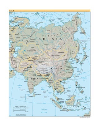
Cia World Factbook Reference Map Asia (20)
The document is a collection of photos and captions describing street children and those living in poverty in various locations around the world, primarily in Brazil. The photos were taken by different photographers and foundations working to help at-risk children and families living in poverty. The captions provide context about the hardships faced by those living in extreme poverty, especially children, in places like Brazil, India, the Philippines, and Rwanda.
This document features a collection of 35 smoke photographs from various photographers. Dry ice was used to create interesting smoke effects in bottles. Other techniques included using lightbulbs, incense, and Photoshop to shape smoke into artistic forms like waves, figures, and symmetrical patterns. Experimenting with the movement and shapes of smoke can produce unexpected and imaginative images.
Cia World Factbook Reference Map Middle Eastalanocu
This map shows the Middle East region, including countries such as Turkey, Syria, Iraq, Iran, Saudi Arabia, Yemen, Israel, and others. Key geographical features are labeled, such as the Black Sea, Caspian Sea, Persian Gulf, and Red Sea. Major cities throughout the region are also indicated on the map.
The central Balkan region document provides a map showing key cities and rivers in central Balkan countries. The map shows locations in Slovenia, Croatia, Serbia, Hungary, Romania, and Bosnia and Herzegovina. Major rivers depicted include the Drava, Tisza, Danube, Sava, and Mures. Cities labeled on the map include Zagreb, Osijek, Novi Sad, Szeged, Timisoara, and Arad.
This map shows the geographic locations of various islands and island groups in the Oceania region of the world, including:
- Major island countries like Australia, New Zealand, Indonesia, Philippines, Japan.
- Small island nations of the Pacific Ocean like Fiji, Tonga, Samoa, Tuvalu, Marshall Islands and others.
- Unincorporated territories of countries in the region labeled on the map.
Cia World Factbook Reference Map South Americaalanocu
The document is a map of South America that shows the countries, major cities, rivers, and seas. It displays political boundaries and place names for countries like Colombia, Venezuela, Guyana, Suriname, Brazil, and others. Major geographical features like the Andes Mountains, Amazon River, and Orinoco River are indicated on the map.
The Arctic region document provides a map showing key geographical features of the Arctic. It notes that the Kuril Islands were occupied by the Soviet Union in 1945 and are currently administered by Russia but claimed by Japan. Sakhalin Island faces similar territorial disputes between Russia and Japan.
This document provides an overview of the Singularity project, which aims to build a new operating system and software platform from scratch with a primary goal of dependability. The Singularity system uses software-isolated processes (SIPs) that provide information hiding, failure isolation, and strong interfaces to encapsulate application and system components. SIPs differ from conventional processes by being closed object and code spaces, communicating through typed channels, and having low overhead for creation and communication. The goal of the Singularity system is to demonstrate how new programming languages, compilers, and analysis tools can enable more robust and dependable software architectures.
Seeing O S Processes To Improve Dependability And Safetyalanocu
This document proposes and evaluates a sealed process architecture as an alternative to the traditional open process architecture used in most modern operating systems. The key aspects of a sealed process architecture are:
1. Code within a process cannot change once execution begins (fixed code invariant).
2. A process's state cannot be directly accessed by other processes (state isolation invariant).
3. All communication between processes is explicit, with sender and receiver control (explicit communication invariant).
4. The kernel API respects the above invariants and does not allow them to be subverted (closed API invariant).
The document describes an implementation of sealed processes in the Singularity operating system and presents preliminary benchmarks showing competitive performance compared to open
Language Support For Fast And Reliable Message Based Communication In S...alanocu
1. The document describes a communication system for the Singularity OS that uses message passing over channels as the sole means of inter-process communication.
2. Channels are bidirectional and consist of two endpoints that are statically typed. Channel contracts specify valid message types and sequences.
3. Safety is ensured through the use of a type-safe language and static verification that guarantees each block of shared memory is owned by only one thread at a time.
The document describes the Singularity project, which aims to redesign operating system architectures and software stacks to improve dependability and trustworthiness. The key architectural features of Singularity systems are software-isolated processes (SIPs) for isolation, contract-based channels for communication between SIPs, and manifest-based programs (MBPs) for verification of system properties. SIPs provide lightweight process isolation through type safety instead of hardware protection. Communication between SIPs occurs via channels defined by message contracts. MBPs specify the code and behavior of processes.
The "Google generation" not so hot at Googling, after allalanocu
A new UK report on the habits of the "Google Generation" finds that kids born since 1993 aren't quite the Internet super-sleuths they're sometimes made out to be.
This document provides instructions for assembling paper airplane models without images or diagrams. It lists the steps to glue identical parts together, attach the wings and fuselage, insert the tail parts, glue on the engines for the Fokker model, and attach the completed display. The models include a Douglas DC-3, Constellation, and Fokker 100.
1. The document provides assembly instructions for a cardboard skatepark model.
2. The skatepark model includes features like banks, quarterpipes, halfpipes, pyramids, stairs, slopes, and curbs.
3. The instructions explain how to cut out and assemble each part, starting with gluing the bottom pieces to cardboard and then assembling and attaching the other pieces like slopes and stairs to complete the skatepark.
Print the 12 pages with over 100 parts on thick (80 grams) paper and start cutting and glueing and make your own personal Bert. See the end result at http://www.bertsimons.nl/zenphoto/paperworks/clone/
This document provides information about Project Gutenberg, including its goals and operations. It discusses Project Gutenberg's mission to distribute one trillion free ebooks by 2001. It also provides contact information and guidelines for donating or communicating with Project Gutenberg.
Pictures made funny by the actions of people/objects in the backgroundalanocu
Pictures can be made humorous by the unintended or unexpected actions of people or objects in the background. These background elements take on an amusing quality when viewed in contrast to the main subject of the photo. Capturing such moments of serendipity can create funny pictures.
Un viaje a Buenos Aires y sus alrededoresJudy Hochberg
A travelogue of my recent trip to Argentina, most to Buenos Aires, but including excursion to Iguazú waterfalls, Tigre, and Colonia del Sacramento in Uruguay
Wayanad-The-Touristry-Heaven to the tour.pptxcosmo-soil
Wayanad, nestled in Kerala's Western Ghats, is a lush paradise renowned for its scenic landscapes, rich biodiversity, and cultural heritage. From trekking Chembra Peak to exploring ancient Edakkal Caves, Wayanad offers thrilling adventures and serene experiences. Its vibrant economy, driven by agriculture and tourism, highlights a harmonious blend of nature, tradition, and modernity.
Assessing the Influence of Transportation on the Tourism Industry in Nigeriagsochially
This research dissertation investigates the complex interplay between transportation and the tourism industry in Nigeria, aiming to unravel critical insights that contribute to the enhancement of the overall tourist experience. The study employs a multi-faceted approach, literature review establishes a robust theoretical framework, incorporating The Service Quality and Satisfaction Theory to guide the research questions and hypotheses.
The methodology involves the distribution of a structured questionnaire, ensuring a representative sample and facilitating a comprehensive analysis of the gathered data.
Key findings include the nuanced perceptions of transportation infrastructure adequacy, safety and security concerns, financial influences on travel decisions, and the cultural and ecological impacts of transportation choices. These findings culminate in a comprehensive set of recommendations for policymakers and practitioners in the Nigerian tourism industry. The findings contribute to the existing literature by providing actionable insights for policymakers, stakeholders, and researchers in the Nigerian tourism sector.
The recommendations encompass gender-sensitive planning, infrastructure enhancements, safety measures, and strategic interventions to address financial constraints, ensuring a holistic and sustainable development of the tourism industry in Nigeria.
Author: Imafidon Osademwingie Martins
How do I plan a Kilimanjaro Climb?
Planning to climb Mount Kilimanjaro is an exciting yet detailed process. Here’s a step-by-step guide to help you prepare for this incredible adventure.
How To Change Your Name On American Airlines Aadvantage.pptxedqour001namechange
American Airlines permits passengers to change/correct names on their AAdvantage account. Also, you can request a name change both online via a web portal and offline over the phone. For further information on how to change your name on American Airlines Advantage, get in touch with the airline’s customer service. Also, you can reach out to a consolidation desk at +1-866-738-0741 for quick assistance.
Discovering Egypt A Step-by-Step Guide to Planning Your Trip.pptImperial Egypt
Travelling to Egypt is like stepping into a time capsule where the past and present coexist, offering a unique blend of history, culture, and stunning landscapes.
See more: https://imperialegypt.com/tour-packages/
Our excursions in tahiti offer stunning lagoon tours, vibrant marine life encounters, and cultural experiences. We ensure unforgettable adventures amidst breathtaking landscapes and serene waters. For more information, mail us at tracey@uniquetahiti.com.
You can easily change/correct a name on your flight ticket under the American Airlines name change policy. The airline provides multiple online and offline modes to place a name change request. To learn more about how to change a name on American Airlines ticket, you can directly approach the airline’s customer support. Moreover, you can connect with a flight expert at +1-866-738-0741 for quick assistance.
What Challenges Await Beginners in SnowshoeingSnowshoe Tahoe
Discover the exhilarating world of snowshoeing through our presentation, highlighting the challenges faced by beginners. From physical exertion to technical finesse and braving harsh winter conditions, each step in the snow brings new obstacles and unforgettable adventures. Embrace the challenge and conquer the winter wonderland with confidence!
Best Places to Stay in New Brunswick, Canada.Mahogany Manor
New Brunswick, a picturesque province in eastern Canada, offers a plethora of unique and charming places to stay for every kind of traveler. From the historic allure of Fredericton and the vibrant culture of Saint John to the natural beauty of Fundy National Park and the serene coastal towns like St. Andrews by-the-Sea, there's something for everyone. Whether you prefer luxury resorts, cozy inns, rustic lodges, or budget-friendly options, the best places to stay in New Brunswick ensure a memorable stay, allowing you to fully immerse yourself in the province's rich history, stunning landscapes, and warm hospitality.
https://www.mmanor.ca/blog/best-5-bed-and-breakfast-new-brunswick-canada
1. ASIA
20
60
80
60
Glasgow
80
Norwegian Svalbard 160 U.S.
(NORWAY) 40
U.K. 140
Sea 60 80 100 120 Wrangel Provideniya
0 FRANZ JOSEF Island
North Sea LAND Arctic Ocean
NORWAY E Anadyr'
'Y
GOR
Oslo NEW SIBERIAN East Siberian
ISLANDS
KOLYMSKOYE NA
DEN. SWEDEN Barents Sea SEVERNAYA Sea
ZEMLYA Cherskiy
Copenhagen 180
Stockholm NOVAYA Laptev Bering
Murmansk ZEMLYA Sea
FINLAND Kara Sea Sea
Kolym
Tallinn
Helsinki
a
RUS. Riga Lake Ladoga
POL. EST. Tiksi KH
RE
LITH. BE
Warsaw Saint T
Vilnius LAT. Arkhangel'sk CHE
VER
Petersburg Lake RSKOGO
Onega
KH
Minsk Noril'sk
OY
AN
ra
S SK Magadan
BELA. ho IN
K HREBET
Le
Pec
Petropavlovsk-
na
T DZHUGDZHUR
A Circle Kamchatskiy
Arctic
T
A
'
Ob
Kyiv
N
Moscow y
I Vil
yu Yakutsk
U
Nizhniy Novgorod
S I B E R
O
UKR. 160
n
Alda
M
Kazan' Sea of
Voronezh a Okhotsk
E
Kharkiv Kam Perm' KURIL
R U S S I A
REB
ISLANDS
Yekaterinburg
KH
Donets'k Saratov lga
Vo Occupied by the Soviet Union in 1945,
Yen
Ufa
Samara Irt na administered by Russia,
isey
L Chelyabinsk ysh Le
Volgograd A Ob Angara claimed by Japan.
r
'
Amu
Rostov
R
T
U
BE Sakhalin
Black Omsk Krasnoyarsk RE
CA
KH
Sea
UC
-
Am
Atyrau Novosibirsk Lake Khabarovsk
YY
AS
ur
TE-ALIN'
(Atyrau) Baikal
OV
US
GEORGIA Astana
ON
Tbilisi
BL
LING
Qaraghandy Irkutsk Sapporo
YA
MTS
SIKHO
ARMENIA Caspian (Karaganda) 40
URIAN PLAIN
.
Sea
Aral KAZAKHSTAN Harbin
GGAN
Yerevan AZERBAIJAN
A
Sea Lake
L
Balkhash Ulaanbaatar
T
Changchun
A
Baku QIZIL Vladivostok
-
HIN
Y
Tabriz QUM
NCH
Sea of Japan
M
UZBEKISTAN S MONGOLIA T JAPAN
T
R
MA
Shenyang
DA
TURKMENISTAN . E NORTH
Almaty E
S KOREA Tokyo
Tehran Ashgabat D
GA Bishkek I Pyongyang
Tashkent
ZAGRO
RA B Yokohama
KYRGYZSTAN Ürümqi O
GU
M T I E N S H A N G Beijing Dalian Seoul - Nagoya
¸ - Mashhad
Esfahan Dushanbe
Baotou Demarcation SOUTH
Osaka
S
Kashi TAKLA MAKAN Line KOREA
Tianjin Yellow Pusan
IRAN TAJIKISTAN
MTS
DESERT Jinan Sea
Yellow
K
Taiyuan Qingdao Fukuoka
Kabul U
.
1972 N 140
-
Shiraz L U MO
UNTAINS
AFGHANISTAN Line of Control N Lanzhou
Indian claim
Xi'an Zhengzhou
Bandar -
Kandahar Line of
A N DS
-
'Abbas Islamabad Nanjing Shanghai
Persian Quetta Actual
QING ZANG GAOYUAN
CHINA East
Indus
Control
Gulf Lahore China
H
IS L
I Wuhan
AN)
Mt. Everest Yangtze Hangzhou
HE
Abu Dhabi M Sea
PAKISTAN (highest point in the world,
NG
A Chengdu
AP
8850 m)
U
U.A.E. Okinawa
DU
New Delhi L
KY
Muscat Changsha
(J
cer
AN
A Lhasa Nanchang
Can
U
SAUDI
NEPAL Y A Chongqing Y
SH
ARABIA Jaipur S Taipei
R of
ic
AN
20 OMAN
-
Karachi Lucknow BHUTAN Guiyang Trop
-
Kanpur Kathmandu Thimphu 20
Gang
dy
- - es aputra Taiwan
wad
Ahmadabad Brahm Kunming
Xi Jiang Guangzhou
Philippine
Irra
Surat
I N D I A BANGLADESH Dhaka Kolkata
Nanning Hong Kong S.A.R.
Macau S.A.R. Sea
Mandalay
Hanoi
Salween
-
Nagpur Chittagong
Mumbai
Pune BURMA Haiphong
DECCAN LAOS Hainan Luzon
WES
- - Dao
Hyderabad S T Nay Pyi Vientiane
HA Taw Manila
Arabian G
TER
RN Hue
TE Rangoon South
Me
S
THAILAND
EA
Sea
ko
N
China PHILIPPINES
ng
Bengaluru Bay of VIETNAM Sea
GHA
Bangkok Cebu
LAKSHADWEEP Chennai Bengal CAMBODIA
TS
(INDIA)
SPRATLY
ANDAMAN ISLANDS Mindanao
Cochin ISLANDS Phnom Sulu Sea
Jaffna (INDIA) Andaman Penh Ho Chi Minh Davao
Sea Gulf of City
Laccadive SRI LANKA Thailand
Bandar Seri
Sea
Colombo NICOBAR Begawan
MALDIVES ISLANDS BRUNEI Celebes Sea 0
0 Male (INDIA)
MALAYSIA
Kuala Lumpur MALAYSIA
Medan
Singapore Borneo
SINGAPORE
Equator Pontianak Celebes
Banda Sea
Sumatra
Makassar
Scale 1:48,000,000
Azimuthal Equal-Area Projection
Palembang I N D Sea N E S I A Dili