California Drought Comparison Chart

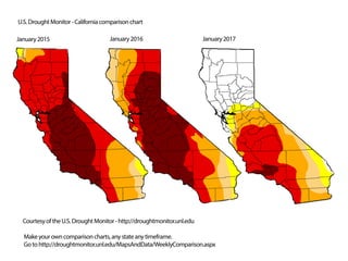
National Drought Summary for January 10, 2017 Summary - A plethora of Pacific storms and moisture slammed into California and most of the West, dumping copious amounts of precipitation on the northern two-thirds of the state and Sierra Nevada. This very wet week maintained the great start to the Water Year (since Oct. 1) across the West where NRCS SNOTEL basin average precipitation was above or much above normal at nearly every major basin while basin average snow water content was at or above normal in most Western basins. With more than a foot of precipitation falling on the Sierra Nevada (locally 20.7 inches at Strawberry Valley, CA), most major reservoirs were at or above its Jan. 10 historical average, USGS monitored streams were at near or record high flows, Jan. 10 state snow water content was at 135%, and the Northern Sierra 8-station, San Joaquin 5-station, and Tulare Basin 6-station precipitation indices topped their wettest previous year as of Jan. 10. Accordingly, major drought improvements were made not only to California but at many areas of the West, including parts of Nevada, Utah, Oregon, Idaho, Montana, Wyoming, and Colorado. There were a few areas in southern California, however, that have yet to receive a bountiful Water Year and see any hydrologic improvements, so no changes were made there. Read more http://droughtmonitor.unl.edu/Home/Narrative.aspx Text Summary courtesy of the U.S. Drought Monitor Website: