2. Mapping Process
I began my mapping process by visiting the town
hall. I spoke with both the building inspector and
the assessors office. The building inspectors
assistant provided me with a printout of my property
from Google Earth which included the property lines
highlighted. After speaking with her about my plans
for the property she went on to tell me that it was a
family horse farm which was handed down through
the generations until a disreputable nephew
inherited and then subsequently lost it. The family
offered riding clinics and lessons to the local
community. It was wonderful to gather this bit of
information and I hope to meet other locals who
may remember the family and the farm.
3. Next I visited the assessors office and requested copies of the assessors
map and the current deed to the property. These were extremely
useful tools as they listed the actual measurements of the property and
the locations of the boundary markers. With this information I started
to sketch out the perimeter of my map.
4. My property has 13+ acres and it took 4
sheets of poster board paper cut up and
taped together to fit the entire space. I
don’t initially plan to utilize all of my
available space, but thought it would be
beneficial to have it all mapped out so
that I can break down different sections
when planning for future uses. The
hardest part was figuring out the angles
and getting them to line up over such a
large area. I tried to sketch it all out
with no success. I decided to cut pieces
of string to the appropriate lengths
taped down the straight edges then
moved around the angles to meet up.
After tracing and checking my
measurements I believe that I have a
fairly accurate rendering.
5. • I then worked on learning the language of design by just spending some
time observing the area and watching where the sun comes up and down.
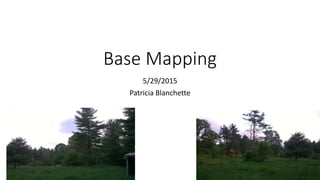
• I also walked the land paying attention to the different
microenvironments. The grass and wildflowers are about waste high right
now and I was a bit startled to see a coyote scurry thankfully away from
me. The grass made walking around and measuring a bit cumbersome, but
it also brought a peacefulness to me as the wind blew in different
directions.
• While walking around I found the location of the old septic which was
literally just a dug out hole in the ground with no leach field. It looked to be
all dried up but that tells me I will need to do some soil testing to
determine the quality or contamination of the soil.
• The existing farmhouse on the property is not included in my base map as
it will be torn down shortly. With it omitted from the map it lets me
visualize how I want to set up my homestead as a productive yet visually
beautiful space.
8. In general I feel that my land can be set up to follow all permaculture
principles. I am extremely fortunate that I have a clean pallet to work
with and have a passion to understand the patterns of nature. I am
motivated to learn and share that knowledge and farming space with
others!