Appartamenti Finiti a Durrazo - AlbaniaIlir Konomi
Apartamenti finiti proprio vicino a mare, Sud di Durrazo.
Una residenza di alta qualita che
Costruito da imprendittori con experienca da 20 anni
30 minuti can makina dall Aeroporto Internationale di Tirana.
Per altri informacioni pottete contatare con:
Albania Property Group LTD
Rruga Kavajes
Tirana Tower 59, Floor 6
Tirana 1002
Albania
Attn: Ilir Konomi - Managing Director
Mobile: +355 67 20 80 001
Mobile: +355 69 40 00 711
Office: +355 44 50 0584
This document discusses spatial analysis techniques to study migration flows in Italy using municipal level data from 1991 to 2007. It uses traditional indexes like the efficacy index of migration and location quotient to assess territorial differences in migrant populations. Spatial autocorrelation is then analyzed using Moran's I, scatter plots, and Local Indicators of Spatial Association (LISA) to identify clusters of high and low values. Three main clusters emerged - a high-high cluster in northeast Italy correlated with employment opportunities, a central high-high cluster, and a southern/island low-low cluster with low incomes and few jobs. Comparing LISA maps over time showed trends in migration patterns correlated with regional economic performance.
A document discusses collaborative e-governance and outlines some key ideas:
1) Collaborative planning processes supported by scientific research tend to create powerful internal networks that can influence policymakers. Participation is different from true collaboration which emphasizes outputs, outcomes, and building social capital.
2) Process thinkers emphasize assessing the performance of collaborative planning by looking at outcomes like social capital, institutional capacity, and innovation rather than just outputs. Science can lead to social outcomes when done collaboratively.
3) Early views of e-governance saw it creating more transparent and cheap interaction between governments and citizens, but the boundaries are messy in reality. Local e-governance studies found poorer cities have more inform
This document discusses a methodology for aggregate analysis of building evacuations. It begins by classifying pedestrian evacuation tools based on the perspective of the model and users, the modelling method, structure of supply models, and measurable outputs. It then discusses using a macroscopic approach for modelling evacuations, representing the demand and supply models topologically as graphs, and computing evacuation time based on guidelines from the International Maritime Organization.
The document discusses decision support systems (DSS) for evacuation planning. It describes the key components and features that a DSS for supply-demand modeling should include. The DSS should allow users to define parameters, integrate with other models and databases, build and visualize the transportation network, and output various indicators to analyze demand-supply interactions and system evolution over time. Tables compare the capabilities of different DSS software applications according to these criteria.
This document discusses decision support systems and software that can be used to model evacuation demand and assist with transportation planning during emergencies. It describes several transportation modeling software packages that can be used to simulate demand through submodels of generation, departure time, distribution, modal split, and path choice. It also discusses the use of revealed preference and stated preference surveys to develop and calibrate demand models when real evacuation data is limited.
This document discusses a methodology for aggregate analysis of building evacuations. It begins by classifying pedestrian evacuation tools based on the perspective of the model and users, the modelling method, structure of supply models, and measurable outputs. It then discusses using a macroscopic approach for modelling evacuations, representing the demand and supply models topologically as graphs, and computing evacuation time based on guidelines from the International Maritime Organization.
Nuovi strumenti per costruire la città democratica. Pianificazione strategica...
Ambiente interattivo per il turismo virtuale, di Salvatore Capotorto, Isabella Gagliardi, Nicola Maiellaro, Luisa Morfini, Marina Zonno
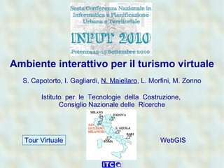
1. Tour Virtuale WebGIS Ambiente interattivo per il turismo virtuale S. Capotorto, I. Gagliardi, N. Maiellaro , L. Morfini, M. Zonno Istituto per le Tecnologie della Costruzione, Consiglio Nazionale delle Ricerche
3. Potenziare i Tour Virtuali – non solo osservazione WEBGIS: Navigazione Ricerca Tour Virtuale: Osservazione Contesto Approfondimenti Siti web: Informazioni Ricerca Semplicita’ d’uso Risorse economiche limitate Competenze minime
5. Virtual Tour – esempi: siti UNESCO Berat, Albania (2007) Butrint, Albania (2008)
6. Sommario 1. Procedure Tour virtuale WebGIS 2. Costruzione di tour virtuale e webgis esemplificativi 3. Esperienza di capacity building in Srebrenica
10. 2. Costruzione di un Tour Virtuale (1/3) Come costruire un’immagine equirettangolare? Rete di immagini equirettangolari
11. Immagine equirettangolare +50° 0° -35° Riprese in situ Assemblaggio S.Maria ad Criptas, Fossa (terremoto dell’Aquila), 2009 Immagine
12. 2. Costruzione di un Tour Virtuale (2/3) Rete di immagini equirettangolari Hotspot e sito virtuale Come costruire hotspots e siti virtuali?
13. Inserimento di hotspot nell’immagine equirettangolare Hotspot (testo – collegamenti) URL sito web di questo sito virtuale Infine, elaborazione automatica del sito virtuale in formato flash
14. Come costruire il contesto? 2. Costruzione di un Tour Virtuale (3/3) Rete di immagini equirettangolari Hotspot e sito virtuale Contesto
15. Contesto fornito da webgis (fasi principali) Google Earth GPS Camera GIS WEBGIS IMMAGINI SITI VIRTUALI
26. Sito virtuale: museo etnografico Live: http://www.tmland.it/virtualtour/bosnia/srebrenica_03_out.swf
27. Ambiente interattivo per il turismo virtuale S. Capotorto, I. Gagliardi, N. Maiellaro, L. Morfini, M. Zonno Istituto per le Tecnologie della Costruzione, (Consiglio Nazionale delle Ricerche) via Lombardia 49, San Giuliano Milanese (MI) Nicola Maiellaro [email_address] “ La semplicità è l’ultima sofisticazione” (Leonardo da Vinci) 3 EXTRA SLIDE LAVORI IN CORSO