Final Karnala
•
0 likes•304 views

Karnala Fort is located near Pen, India and dates back to the 12th or 13th century. The fort has a unique pinnacle shaped like a thumb that can be seen from the Mumbai-Goa highway. The fort has caves carved into the pinnacle and cisterns for collecting water. It has historically been ruled by several powers and was an important strategic fortification overlooking the surrounding region. The fort offers scenic views and is a popular spot for hikers and rock climbers to explore.

Recommended
More Related Content
Similar to Final Karnala
Similar to Final Karnala (20)
More from Rajeev Kulkarni
More from Rajeev Kulkarni (13)
Recently uploaded
Recently uploaded (20)
Final Karnala
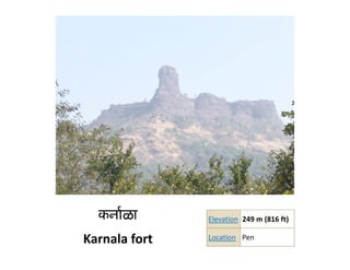
- 1. कनार्ळा Elevation 249 m (816 ft) 249 m (816 ft) Karnala fort Location Pen
- 2. Karnala While going on the Mumbai‐Goa highway we might have noticed a thumb like rock resting on a mountain. As we leave Panvel, the road towards Pen goes through green forests, and suddenly we have a glimpse of this pinnacle. That is the fort of Karnala; famous for its strange pinnacle and the bird sanctuary that is setup in the forests below. This was an important fort and dates back to 12th or 13th century. Till 15th century the fort was under Nizamshahi rule. When Shivaji wanted to capture the fort, his army y j p , y initially surrounded the fort. They built temporary obstructions and continued to attack. After a few days, they captured the fort. After that the Moguls, the Angres and Peshwas ruled the fort. In 1818, colonel Prother of the British captured it. Finally the tricolour was furled here. However the cisterns here show that the fort is ancient and dates back to 12th century. y As we proceed ahead of Karmaidevi temple, we ascend through the main entrance door. Going right is the way to the base of the pinnacle and the caves carved out in it. The northern face of the pinnacle houses many beehives. Hence no sound should be made while going this way. Going rightwards we can see another entrance, but the way here is bit difficult. If we go to the left side, there are remnants of old dwelling places. entrance but the way here is bit difficult If we go to the left side there are remnants of old dwelling places Here are some tanks. There are many cisterns near the caves, but none of them contains potable water. A cistern on the left side, near the remnants, towards steep side of the fort contains drinking water. We enter the fort from northern side. Going southwards beyond the pinnacle, we can observe the ramparts in good condition. We climb some steps and come to the southern Machi. This face of the pinnacle is clear and condition We climb some steps and come to the southern Machi This face of the pinnacle is clear and suitable for rock climbers. A further southward is another bastion. On the entrance here are the carvings of “SHARABH”, which is a legendary animal. Here are the remnants old constructions. On the western face, there is not a clear way. Some caves are situated here. From the top of the fort we can see Prabalgad, Irshaalgad, Dhaak and forts of Rajmachi. On the west are From the top of the fort we can see Prabalgad Irshaalgad Dhaak and forts of Rajmachi On the west are Mumbai and Elephanta islands. The forts visible from here show a strong network to keep a check on the surrounding region..
- 3. View from Mumbai‐Goa Highway
- 5. Un spoilt Un hurried Un touched Un confined Un expected Un conquered Un paralleled Un paralleled Un matched Un stressed Un stressed Un limited Standing as silent sentinels to history are the 350‐odd forts of Maharashtra. Beaten by g y y the sea waves, lashed at by the torrential Deccan rains, or scorched in the blazing sun, stand imposing ramparts and crumbling walls , the last lingering memories of Maharashtra's martial times. Nowhere in the country would you encounter such a profusion of forts. And such variety. Sited on an island, or guarding the seas or among the Sahyadri hills, whose zig‐zag walls and rounded bastions sit like a scepter and crown amidst hills turned mauve.