Unlocking the Power of ChatGPT and AI in Testing - A Real-World Look, present...
Caracteristica general de los puertos ecuatorianos
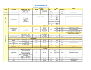
1. ECUADORIAN PORTS
GENERAL CHARACTERISTICS
Access Chanel Docks Comments
Location Port/Terminal Geographic Position (WGS‐84) Max draft comments Depth Lenght Maximum Draft
Port Captain Building light Short acces channel,
latitude: 00º 59" 350 m.
11,5m. Esmeraldas River 11,5 m. 11,0m.
Esmeraldas Port Authority 27.650612" North (N) Breakwater protection.
Long;79º 38" 7 m. 105 m.
4,50 m.
45.371" West (W) (at low tide) (services)
# 1
11 m
200 m
Direct acces from the sea
# 2
Breakwater Light 12 m 200 m
Latitude: 00º 55" # 3
11 m 200 m
Manta Port Authority 46.97852" South (S)
# 4
Long 80º 43"
11m 200 m
10.39520" West (W)
RoRo1
7 m 13 m
RoRo2
7 m 13 m
ESTERO SALADO:
Until 8.20 m: 925 m. 10,0 m. 5 berths ( Contecon ‐ general cargo)
Dock # 6
Guayaquil Port Authority direct acces
Latitude: 02º 16" 42.51393" South (S)
‐Contecon S.A 9,75 m. 8.20 m until 9.75 m 10,0 m. 555 m. 10,0 m. 3 berths (Contecon containers)
Long: 79º 54"
‐Andipuerto S.A entering with hide
43.67656" West (W)
tide only. 155 m. 10,0 m. 1 berths (Andipuerto‐ bulk and general cargo)
Resolution Digmer No 100/07 ‐ R.O No. 100. 7/June/07:
Resolution Digmer No. 100/07 R O No 100 7/June/07:
ESTERO MUERTO:
Navigational rules for Estero del Muerto
Latitude: 02º 15" 5.53" South (S) Enter channel with
Electroguayas Central 9,75 m. 9 m. 110 m. 7,00 m.
Long: 79º 54" 36.35 West (W) high tide
Latitude: 02º 15" 16.2101" South (S) Enter channel with
Terminal Portuario Fertisa 9,75 m. 10.5 m 297 m. 9,75 m.
Long: 79º 54" 33.6625 West (W) high tide Solid and liquid bulk, general cargo, fruits and containers.
ESTERO SANTA ANA:
Latitude: 02º 15" 05.66778" South (S) Long: 79º Fruits, containers, vehicles, general cargo and IMO
Banapuerto 9,75 m. High tide 10 m. 320 m.
55" 37.52482" West (W) 9,75 m. cargo
Latitude: 02º 14" 59.6188" South (S) Long: 79º
Trinipuerto High tide 11 m. 125 m. Break bulk and general cargo
55" 39.1943" West (W) 9,75 m. 9,75 m.
Terminal Portuario de Guayaquil ‐ Latitude: 02º 14" 46.72154" South (S) Long: 79º
9,75 m. High tide 360 m. Containers Terminal
TPG 55" 44.86813" West (W) 12 m. 9,75 m.
PUERTO HONDO 3.5 m and 7.5 m Low tide and High tide 77 m Bulk: minerals
RIO GUAYAS:
Latitude: 02° 10' 19.29" South (S)
Santorisa Long: 79° 51' 28.79" West (W) 6,5 m. High tide 7 m. 50 m. 6,50 m. For discharge break bulk, 6 dekes of mooring
89m long (2 mooring
Industrial Molinera Latitude: 02° 14' 02.48" South (S) 6,5 m. High tide 8,5 m. dolphings, 3 dolphings 6,50 m. For discharge solid and liquid bulk
at berth)
Long: 79° 53' 05.78" West (W)
Latitude: 02° 13' 06.03" South (S) Long: 79° 53'
Ecuabulk 6,5 m. High tide 9,70 m. 9,5 m. (platform) 6,7 m. Discharge luse oil and asphalt.
08.09" West (W)
Latitude: 02° 14' 6.0006" South (S)
Emolsa 6,5 m. High tide 8,5 m. 50 m. 6,7 m. Liquid Bulk, asphalt
Long: 79° 53' 5.1482" West (W)
Latitude: 02° 14' 13.59" South (S) Break bulk and containers
Timsa 6,5 m. High tide 8,5 m. 200 m. 6,7 m.
Long: 79° 53' 02.942 West (W) ( feeder to Galapagos Island)
Latitude: 02° 14' 37.5754" South (S)
Vopak 6,5 m. High tide 8,5 m. 120 m. 6,7 m. Solid and liquid bulk
Long: 79° 52' 49.6835 West (W)
2. Length front to water: 126m. Solid bulk and
Ecuagrán Latitude: 02° 14' 33.5398" South ( S) 6,5 m. High tide 11,0 m. 100 m. 6,7 m. general cargo in bags. Bulk vessels with 200m.
Long. 79° 52' 52.5999 West (W) Of length
Latitude: 02° 14' 9.5816" South (S)
La Favorita 6,5 m. High tide 7 m. Platform 6,7 m. Oil, lubricants
Long: 79° 53' 3.9478" West (W)
Lubriansa (Ex Macasa) 6,5m. High tide 7 m. 102 m. 6,0 m. Oil, lubricants
Latitude: 02° 10' 19.29" South (S)
Termoguayas Generation 6,5m. High tide 7,20 m. 100 m. 6,50 m.
Long: 79° 51' 28.79" West (W)
Latitude: 02° 14' 02.48" South (S)
Intervisa Trade 6,5m. High tide 7,20 m. 6,50 m.
Long: 79° 53' 05.78" West (W)
Note: (Terminals on Rio Guayas) :Maximun "6.5m.entering from P/S with high tide
Terminal Marítima de Gas
Monteverde
10.5 m. 360 m. (marginal) 10 m. 2 berths
Latitude: 03° 15' 40.67348" South (S)
Bolívar Port Authority 10 m.
Long: 80° 00' 01.96364" West (W) 130 mts.
10.5 m. 2 berths
(breakwater) 10 m.
Latitude: 00° 26' 28" South (S)
Isla Baltra Direct acces from sea 5,5 m. 77,3 mts. 5,0 m. Oil and passengers terminal
Long: 90° 15' 43" West (W)
Oil Terminals
Access Channel Depht Depht Limitationes Maximun Draft Comments
Buoy "Y" (SBM) Latitude: 01° 02' 00" North. 100.000 Tons. DW
Direct acces from sea 2 monobuoys. Buoys X and Y
Long: 79° 42' 09" West > 35 m. +/‐7%
SOTE Buoy "Y" (SBM) Latitude: 01° 02' 02" North.
Long: 79° 41' 08" West
Buoy "A" Latitude: 01° 01' 23" North.
Direct acces from sea 40.000 Tons. DW 12 m. A quadrilateral of buoys. Maximum length 185 m.
Long: 79° 40' 39" West 17 m.(4 buoys)
Buoy "B" Latitude: 01° 01' 24" North.
Long: 79° 40' 33" West
TEPRE
Buoy "C" Latitude: 01° 01' 12" North.
Long: 79° 40' 31" West
Buoy "D" Latitude: 01° 01' 20" North.
Long: 79° 40' 39" West
Buoy "C" Latitude: 01° 01' 17" North.
150.000 Tons. DW 18 m. Monobuoy Charlie ‐ C
Long: 79° 43' 59" West C 29 m.
OCP Ecuador Direct acces from sea
Buoy "P" Latitude: 01° 01' 47" North.
325.000 Tons. DW 32 m. Monobuoy Papa ‐ P
Long: 79° 44' 44" West P 37 m.
Latitude: 02° 9' 44.2661" South (S) 11,5 m.( depth of
Boyas Internacionales 12,5 m. 10,5 m. Diurnal operation with tugs
Long: 80° 55' 55.5674" West (W) buoys)
Latitude: 02° 13' 00.67" South (S) 4,5 m. ( depth of
Muelle de Petropenínsula 4,5 m. 108 length overall 4,2 m. With high tide for mooring of: 6.2 m.
Long: 80° 54' 23.49" West (W) buoys)
Cautivo 1 ‐ Latitude: 02° 12' 40.3303" South (S) 5.5 m. (depth of
6 m. 5,50 m. With high tide for cast of: 8.0 m.
Long: 80° 53' 34.7554" West (W) buoys)
Cautivo 2 ‐ Latitude: 02° 12' 42.7407" South (S)
Boya de Cautivo
Long: 80° 53' 39.0289" West (W)
Cautivo 3 ‐ Latitude: 02° 12' 36.2271" South (S)
Long: 80° 53' 43.9181" West (W)
18,5 m. (along
Salitral/ Suinsa Latitude: 02° 13' 47.55" South (S) 9,75 m. mooring dolphins 20.000 Tons. DW 9,75 m. Clean products, 4 mooring dolphins
Long: 79° 57' 29.44" West (W) and anchorage)
Latitude: 02° 13' 53.96196" South (S)
LPG 9,75 m. 5.000 Tons. DW 6,0 m. 1 berth, 2 mooring dolphins
Long: 79° 57' 26.86011" West (W) 6,5 m.
Latitude: 02° 13' 51.87" South (S)
Fuel Oil 9,75 m. 5.000 Tons. DW 6,0 m. 1 berth, 2 mooring dolphins
Long: 79° 57' 30.29" West (W) 6,5 m.
Latitude: 03° 04' 19.82" South (S) 11,5 m.
Punta arenas 15 m. 60.000 Tons. DW 10,50 m. LPG floating deposit. LPG and oils discharge.
Long: 80° 06' 40.07" West (W) (anchorage)