
Recommended
More Related Content
What's hot
What's hot (20)
Viewers also liked
Viewers also liked (18)
Similar to Beautiful Keld Walk Through Swaledale With Epic Views
Similar to Beautiful Keld Walk Through Swaledale With Epic Views (14)
Recently uploaded
Recently uploaded (20)
Beautiful Keld Walk Through Swaledale With Epic Views
- 2. Distance Covered: 6 miles Time to complete walk: 3 hours A walk with beautiful cascading waterfalls and epic panoramic views of Swaledale. The drive to the remote village of Keld is on winding country roads and an adventure in itself. Give yourself plenty of time for the walk and ensure you complete the walk in sunny dry weather as the rocky path of the Pennine Way can be precarious if the path is muddy or slippy.
- 3. Getting There If travelling from Middlesbrough, take the A66 to Scotch Corner then take the A6108 through Richmond and then follow it and look for a right turn off to Reeth. Exit Reeth and take the B6270 and follow this windy country road until you eventually come to Keld. Parking can be found at the Park Lodge carpark further into Keld
- 4. Map of the Keld walk
- 5. From the car park walk ahead down a gravel path signed Muker. Continue along the path as it rises ignoring the path that goes down to the left. Go through a gate, pass a sign to Kilsdon Upper Force and continue on the path which carries on below a crag and to a signpost.
- 6. Turn right which is on the Penine Way and go up to a gap in the wall. and to another signpost.
- 7. The path can be slippy and precarious in frost or after rain, so take special care negotiating the rocky path. Follow the path as it goes over rocky ground and slopes. Cross a ladder stile as the path starts to descend. You will have amazing views as you follow the path. You will cross over more stiles.
- 8. Go down to a signpost and you will come across a signpost to the Pennine Way. Ignore that path and join a walled track signed Muker. The track is gravelled and works its way down to the village of Muker.
- 9. You will pass a house and then to your left look for a path signed Public Footpath. If you struggle to find it as long as you don't go down into the main village of Muker you will find it. Follow the path through six gates towards the River Swale.
- 10. Turn a sharp right when you reach the river and look for a footbridge over the river.
- 11. Ascend steps beyond the footbridge and turn left where it is signed Keld. Follow the clear track along the valley, until it curves right into Swimmer Gill. Take a short detour to see the waterfall. It really is beautiful.
- 12. Cross the footbridge and head up to a gate.
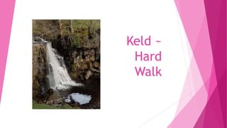
- 13. Start climbing the track and follow it around an old barn. Continue steadily downhill and you will come to a gate above East Gill Force. Fork left when you come to a wooden seat and you will then be able to admire the waterfalls.
- 15. After you have visited the waterfalls follow the path over a footbridge, then bear right uphill and you will be on the track you started you walk on. Head back to Keld for some food and refreshment!