Beginners Guide to TikTok for Search - Rachel Pearson - We are Tilt __ Bright...
PSLP-SitRep
1. A product of the Virginia Department of Emergency Management
Cross-Sector Communication
Tropical Storm Arthur
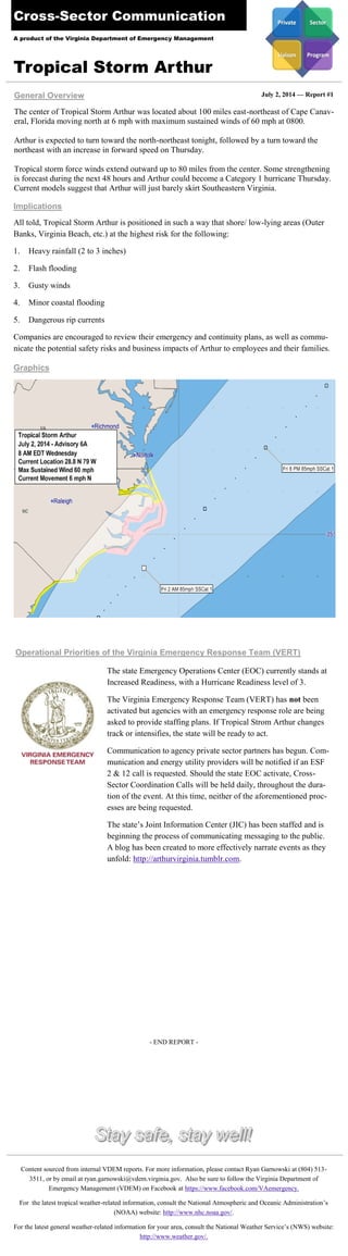
The center of Tropical Storm Arthur was located about 100 miles east-northeast of Cape Canav-eral,
Florida moving north at 6 mph with maximum sustained winds of 60 mph at 0800.
Arthur is expected to turn toward the north-northeast tonight, followed by a turn toward the
northeast with an increase in forward speed on Thursday.
Tropical storm force winds extend outward up to 80 miles from the center. Some strengthening
is forecast during the next 48 hours and Arthur could become a Category 1 hurricane Thursday.
Current models suggest that Arthur will just barely skirt Southeastern Virginia.
General Overview July 2, 2014 — Report #1
Operational Priorities of the Virginia Emergency Response Team (VERT)
The state Emergency Operations Center (EOC) currently stands at
Increased Readiness, with a Hurricane Readiness level of 3.
The Virginia Emergency Response Team (VERT) has not been
activated but agencies with an emergency response role are being
asked to provide staffing plans. If Tropical Strom Arthur changes
track or intensifies, the state will be ready to act.
Communication to agency private sector partners has begun. Com-munication
and energy utility providers will be notified if an ESF
2 & 12 call is requested. Should the state EOC activate, Cross-
Sector Coordination Calls will be held daily, throughout the dura-tion
of the event. At this time, neither of the aforementioned proc-esses
are being requested.
The state’s Joint Information Center (JIC) has been staffed and is
beginning the process of communicating messaging to the public.
A blog has been created to more effectively narrate events as they
unfold: http://arthurvirginia.tumblr.com.
Content sourced from internal VDEM reports. For more information, please contact Ryan Garnowski at (804) 513-
3511, or by email at ryan.garnowski@vdem.virginia.gov. Also be sure to follow the Virginia Department of
Emergency Management (VDEM) on Facebook at https://www.facebook.com/VAemergency.
For the latest tropical weather-related information, consult the National Atmospheric and Oceanic Administration’s
(NOAA) website: http://www.nhc.noaa.gov/.
For the latest general weather-related information for your area, consult the National Weather Service’s (NWS) website:
http://www.weather.gov/.
All told, Tropical Storm Arthur is positioned in such a way that shore/ low-lying areas (Outer
Banks, Virginia Beach, etc.) at the highest risk for the following:
1. Heavy rainfall (2 to 3 inches)
2. Flash flooding
3. Gusty winds
4. Minor coastal flooding
5. Dangerous rip currents
Companies are encouraged to review their emergency and continuity plans, as well as commu-nicate
the potential safety risks and business impacts of Arthur to employees and their families.
Implications
Graphics
- END REPORT -