SlideShare a Scribd company logo
1 of 5
Download to read offline
Snuggled between two wilderness
areas in the icy-cold headwaters of
the John Day River, 13,000 acres of
once privately held timberlands is
now open for all to hunt, hike, fish
and explore.
JOHNDAY
H
igh along the ridges south of Prairie City
in northeast Oregon, the John Day River is
born. Hundreds of tiny springs and rivulets
of snowmelt trickle down hillsides as they weave
their way through elk summer range. The creeks pass
through decades-old clearcuts thick and green with
two-story-tall lodgepoles—perfectly square sections
of once privately managed timberlands. Without
warning, the creeks hit a wall of old-growth spruce
with live, dead and dying trees—640-acre sections
of public land managed by the US Forest Service.
For some creeks, this boundary hopping goes on for
miles. By the time the water nears County Road 62,
the creeks have merged to become the John Day River,
meandering through ponderosas and knee-high grass.
It’s a good place to be an elk, but it’s a management
nightmare of checker-boarded public and private
land—at least that’s how it used to be.
Under a blue spring sky, I ride shotgun with
Bill Richardson, RMEF lands program manager
(LPM) for Oregon and Washington. From the road
above the John Day, he points out far ridges where
some 20 years ago he and a friend drove where only
a Land Cruiser could go. We don’t go there today in
his Dodge, but we do turn off the pavement and inch
our way to a spot he’s picked out. We pass two open
gates, and with each fork in the road the trees close in.
Overhanging limbs screech along the doors. “Redneck
pinstripes,” Bill says with a grin. Finally, a tree hangs
across the road. I get the feeling Bill goes few places
without his Stihl chainsaw with a 32” bar. Firewood
grows big where he lives in western Oregon.
The whine of the saw breaks the stillness for
only a moment. We climb again until the ridge
flattens out and park under several old, sagging
meat poles. In front of a stand of ponderosa pines
sits a knee-high memorial for a son and a father:
“Whose favorite season was elk,” it reads. This was
a family’s elk camp. I can see why they liked it here.
Finger ridges jut every cardinal direction. You can
hunt up or down, whatever suits your mood and the
prevailing thermals. Not far away, you can summit a
peak covered in talus and glass the drainages in one
Bringing It All Together
by PJ DelHomme
62 • BUGLE • NOV/DEC 2014 NOV/DEC 2014 • BUGLE • 63
a bow. “I saw some bulls in the 350-class or better,
but they were all on private land. It seems those bulls
hang out in the wilderness until snow or hunting
pressure causes them to beeline it down to the private
ranches below. The key is timing it so you catch
them in the transition, which includes some of the
Headwaters project area.”
Justin Karnopp grew up in Oregon and hunted
that area with his family in the early 1990s (see
his story on page 44). They would base camp just
outside the Strawberry Mountain Wilderness and
then hike in, which is a good strategy given the area’s
popularity.
“There are lots of bowhunters, and you really
have to hike to get away from them and into the elk,
which are educated, especially during bow season,”
says Karnopp. One good way to ditch the crowds is
to take advantage of a three-week-long traditional
archery-only (long or recurve bows) season in a
portion of Unit 46 called Canyon Creek.
And while Karnopp is a die-hard elk hunter, it’s
not the bugling bulls that would keep him up at night
in camp. The thick woods and folklore of the area has
more than a couple tales of the unexplainable.
“That’s sasquatch country, man,” says Karnopp.
“It’s a place where things go bump in the night.”
Sink or Swim
Bigfoot stories aside, the area has seen its share
of spooky moments, most recently when America’s
housing bubble burst in the late 2000s. The housing
market reached its peak in 2006. A short while later,
market prices started to tank, and people were
looking to unload their investment property before
it hit rock bottom. And no one knew how low that
would actually be.
Hired by the RMEF in 2009, Bill Richardson
had heard through the grapevine that 23 sections of
land belonging to a family-owned timber company
were going up for sale. Realtors, sporting property
companies and neighboring ranches all had interest.
Based on the track record of surrounding lands, the
threat of development was very real. In fact, private
development along the edges of public land in
Oregon and Washington more than doubled since the
1970s, according to a study by the US Forest Service
Pacific Northwest Research Station. These parcels
were gems, and a number of them had ideal building
sites with access roads and gates already established.
Yet the family that owned the property was
reluctant to let it go. The D.R. Johnson Lumber
Company, based in southwest Oregon, owned the
sections that owner Don Johnson first purchased back
in 2001. The land had been heavily logged by Crown
Pacific in the early 1990s, but in a move common in
the timber industry, Don bought the land aiming to
sell or trade it for other ready-to-log timberlands.
He passed away, though, in 2012, and his family was
looking to sell the property. For Richardson, there was
no time to ease into his role as LPM with a couple of
small projects.
“As a new LPM, it was like holy cow, this is
awesome right out of the gate,” he says. But the
project was hardly a slam dunk. At every turn in the
process, the road to completion kept getting narrower,
constantly threatening to block further progress.
By far, the largest monetary contributor to the success of
RMEF’s permanent land protection projects has been the Land
and Water Conservation Fund (LWCF)—and the future of that
fund is uncertain.
Since 1965, royalties from offshore oil and gas drilling
have been allocated to the LWCF. At full-funding, the fund is
supposed to have $900 million in its coffers to protect key
pieces of wild country and safeguard clean water sources.
But the fund is always raided for Congressional pet projects;
only once has it ever been fully funded. Even so, the fund has
contributed more than $62 million to RMEF projects, helping
to permanently protect more than 62,000 acres of prime elk
country. Since its inception, LWCF has contributed $16 billion
to national wildlife refuges, forests, parks, historic and scenic
trails, wild and scenic river corridors, national battlefields and
monuments, and other federal lands.
RMEF's long partnership with LWCF started in 1989 with a
$7 million LWCF grant to help the RMEF acquire some of the
most vital winter range for Yellowstone’s northern herd. Since
then, California’s Cache
Creek, Montana’s Iron
Mask and Tenderfoot Creek,
South Dakota’s Wildcat
Canyon and more have all
been made possible by money
from the LWCF. Most recently, the
LWCF contributed $2 million for the John
Day Headwaters project. But that could all change next fall.
On September 30, 2015, the 50th Anniversary of the
creation of the LWCF, it will “sunset” or cease to exist if not
re-authorized by Congress. It is imperative that Congress
hear from you. No other Congressional program does more
to directly benefit elk and their habitat—and elk hunters.
Conservation and hunting have always been bipartisan
values. Consider calling or writing your member of Congress
to express your support for the future of the LWCF and
elk country.
—PJD
NOT ALL SUNSETS ARE PRETTY
of two roadless areas nearby, bugling until you get an
answer. It’s perfect.
The hunting camp sits just inside the public land
boundary, and anyone can make camp here. Yet some
of the roads we drive bisect what
was once private timberland.
We pass numerous gates, which
easily could be padlocked,
barring access to both private and
public land beyond. But that’s not
how things turned out. Thanks
to the efforts of RMEF staff and
volunteers, foundations, a willing
landowner and government
agencies, the RMEF was able to
purchase 13,000 acres of private
timberland in prime elk country
and then transfer that acreage to the Forest Service the
same day. The project not only secured public access
to the 13,000 acres, it created an unbroken expanse of
roughly 51,000 acres of great elk habitat.
Some of Oregon’s finest elk country is found in
the southern Blue Mountains on the Malheur National
Forest. The project area lies within Grant County,
which holds the most Boone & Crockett entries for
typical Rocky Mountain elk in the state, according
to records of the Boone & Crockett Club. The last
“Booner” was taken in 1984, and now the area is
managed for 15 bulls/100 cows,
which produces opportunity and a
chance at some quality bulls, says
Ryan Torland, Oregon Department
of Fish and Wildlife (ODFW)
biologist for the John Day country.
“Traditionally some good bulls are
taken out of that Murderers Creek
unit because of the wilderness
area and the places they can hide,”
he says.
Much of the project area sits
within the Murderers Creek Unit
46, where archery tags are still over-the-counter and
rifle hunters can draw a tag roughly every three years.
“There are a ton of elk in the area, but it gets a
lot of pressure during archery season,” says Chad
Klinkenborg, RMEF’s northern Oregon regional
director. He hunted the area last year with a
muzzleloader, but says he’s going in next year with
The project not only
secured public access to
the 13,000 acres, it created
an unbroken expanse of
roughly 51,000 acres of
great elk habitat.
64 • BUGLE • NOV/DEC 2014 NOV/DEC 2014 • BUGLE • 65
The process took roughly five years. Just getting
an appraisal for the property required Richardson
to shuttle the appraisers to the 23 sections, totaling
500 miles and five days’ worth of redneck pinstripes.
And when the appraisal did come in, it was mighty
low, nearing the original purchase price back in 2001.
The Johnson family was dismayed, and was ready
to walk away from the table, and at times they did.
But they came back because that’s what Don would
have wanted.
“My husband loved the outdoors and hunting,”
says JoAnne Johnson, Don’s widow and co-owner
of D.R. Johnson Lumber Company. “Don always felt
that ultimately blocking up our sections with the
Forest Service property made the most sense. It is
the family’s hope and desire that now this beautiful
and unique area will remain accessible for hunters,
fishermen and all outdoorsmen, and that it will
receive some much-needed forest management as
well. It is a bittersweet moment for us, but we believe
Don would want the citizens of Grant County to be
able to enjoy this amazing property for generations
to come.”
The low appraisal wasn’t the only tree in the
road. Some county commissioners didn’t like the
idea of private land being turned over to the federal
government. One argument against the sale was that
the county would lose some of its tax base, which is
only partly true. While the Forest Service does not
pay property taxes on federal land, counties instead
receive payments in lieu of taxes (PILT) from the
US government that help offset losses in property
taxes due to non-taxable federal lands within their
boundaries. In 2014, Grant Country received $630,591
for 1.75 million acres of federal land. In 2013, it
was $581,458.
Because the land in the project area was private
timberland, it was taxed at a lower rate than standard
property tax. But when timber or agriculture land
is taken out of production, being either developed,
sold or transferred to the Forest Service, the sellers
are subject to a “recapture tax.” In this case, the law
calls on the landowner to pay five years’ worth of
back property taxes on the land once it is no longer
classified as timberland. Ultimately, the county
received an additional $265,000 because of the
recapture tax.
“Some projects are easier than others, but this
wasn’t one of the easy ones,” says Jennifer Doherty,
the RMEF’s director of lands. “Without Bill’s tenacity,
the Johnson family’s patience, and effort from
countless other individuals and organizations, this
vital chunk of elk country never would have made its
way to the public domain.”
A Fishery Stronghold
The headwaters of the John Day is home to
roughly 500 elk from May to September that spend
the warmer months following green-up as the snow
recedes. The project area is also a key migration
corridor. Idaho fescue and mountain mahogany
share hillsides with scattered ponderosas, lodgepole
and spruce. Very few non-native plants have made
inroads here.
The elk cross paths with mule deer, mountain
goats, black bears and even the occasional wolverine.
While the elk and potential victory for hunter access
were what first attracted the RMEF to the project, it
was the “other wildlife” of the area that helped secure
the $7.5 million to purchase the property. Namely,
wildlife elk hunters rarely see, hidden beneath the
waters of the John Day and its tributaries.
Tim Unterwegner, a RMEF Life Member since
1995, spent more than three decades as a fish biologist
with the Oregon Department of Fish and Wildlife.
He’s lived in John Day for 20 years and spent the
last 16 years as finance chair for the RMEF’s John
Day Chapter.
“That retired fish squeezer had data on all
the streams,” says Richardson. “It’s what made
the project.”
It made the project because the John Day is
the longest free-flowing (undammed) river west
of the Continental Divide, and the project directly
impacted 35 miles of stream in the watershed. The
river’s list of native species reads like a who’s who of
the threatened and endangered variety. It’s home to
the threatened bull trout that spawns in headwater
streams. It has one of the largest wild runs of spring
chinook left in the Columbia River Basin. It holds
Oregon’s only known population of westslope
cutthroat trout. And here, threatened summer
steelhead have their healthiest run in the Columbia
River watershed.
“When we work to protect and conserve elk
habitat, we really do have to look at the big picture,”
Day was a classic mountain man. Born in Virginia in
1770, he trapped and explored the West on the heels of
Lewis and Clark. Nowadays, his name is immortalized
in a national monument, two Oregon towns, and a
dam on the Columbia. Perhaps his best known tribute,
though, is the river that now bears his name.
In 1811, camped in east-central Oregon where the
river the early Native Americans called Mah-hah flows
into the Columbia, John Day was robbed. He and a
companion were stripped of everything, including the
clothes on their backs. A year later, they stumbled into
Fort Astoria, more than 300 miles from their unfortunate
encounter with the locals.
—PJD
WHO WAS JOHN DAY?
says Bob Springer, RMEF project development
specialist. “For the John Day, finding money just to
conserve elk habitat and access would have been
tough without the tremendous fisheries component,
not to mention the area’s sensitive bird and
amphibian species.”
Those cold spawning streams that start high
in the John Day country put this project as the
number one funding priority for the Land and
Water Conservation Fund (LWCF). That fund alone
contributed $2 million toward the purchase. (See
sidebar on page 65.)
The project also pulled in $500,000 from the
National Fish and Wildlife Foundation—Acres for
America Program, a program created by Walmart
in 2005 to permanently conserve at least one acre of
wildlife habitat for every developed acre of Walmart
Stores’ current and future footprint. Walmart’s
footprint is roughly 138,000 acres, but the program
has since impacted 850,000 acres, including the John
Day Headwaters project.
“I don’t know if you fully realize the impact
of the RMEF until you get out on the ground,”
says Kevin Sweet, senior director of real estate for
Walmart. “If it wasn’t for the RMEF, no one would
have stepped in and put this all together. Our first
stop on the tour was an overlook where you look
down at the valley below. That’s when I got the
perspective of what this could have been. That is the
prime spot for a million dollar cabin, because it has
a million dollar view. From blocking up the land, to
conserving the elk and fish habitat, this whole thing is
a great story.”
The remaining portion of the $5 million came
from the RMEF’s Torstenson Family Endowment and
a private donor who asked to remain anonymous.
The fish that helped net those funds also pump a
lot of money into local economies.
“We get hundreds of fishermen every season,”
says Mia Sheppard, who, along with her husband
Marty, has owned Little Creek Outfitters on the John
Day for more than a decade. And while they are
based out of Condon, 120 miles downstream of the
headwaters, what happens in the headwaters has a
direct impact on their business. “The summer run of
steelhead are very special here. They start stacking up
66 • BUGLE • NOV/DEC 2014 NOV/DEC 2014 • BUGLE • 67
The early stretches of the John Day weave through Oregon's lush elk country.
at the confluence of the John Day and the Columbia
River in July, but water temps in the John Day are
over 70 degrees, which is too hot for them to move
upstream,” she says.
“They wait for the water to get cold in the
fall, then make their way to the upper tributaries to
spawn. If the water never gets cold enough, then they
move on to another river. It’s a lifecycle; whatever
happens in the headwaters happens downstream.
Less fish into the river, means less fish into the
headwaters to spawn.”
Little Creek Outfitters employs seven guides
during the steelhead season in the fall, and when
fishermen come to town, they bring their checkbooks
with them.
“They stay two or three nights in local hotels,
eat out in town,” Sheppard says. “And we gas
up our rigs, buy groceries and pay the mechanic
when bearings blow out. We’re supporting the
local values of the local ranching community. It’s a
way of life here, which has to be balanced with the
recreational community.”
In 2008 in Grant County alone, travel-related
revenues from fishing, hunting and wildlife watching
totaled more than $11.5 million, according to a 2008
study. Fishing accounts for $3.2 million, hunting $5.1
million, and wildlife watching $3.1 million.
Not every elk hunter likes to wet a line, so why
would they care about healthy fish habitat? “It’s
no secret that intact headwaters produce the finest
quality water and the best habitat for a number
of species, including elk,” says Unterwegner. “It’s
On August 17, 2012, Malheur Lumber, the last major
sawmill in Grant County, was going to close. “The issue
was uncertainty,” says Bruce Daucsavage, Ochoco Lumber
president. “I wasn’t going to put another nickel into that plant.
We just couldn’t find enough profitable wood. We were going to
lay off 80 people.”
Even though forest supervisors and community members
had worked to implement an accelerated forest restoration
program on 600,000 acres on the Malheur National Forest
after colossal fires in 2000, it wasn’t enough to keep that mill
going and the forest healthy. With unemployment rates in Grant
County at nearly 13.6 percent in 2012, something needed
to happen.
After the announcement, Daucsavage was invited to
Oregon Senator Ron Wyden’s office. In a week, Daucsavage
put together a plan of what the timber industry needed in
eastern Oregon to stay alive. At the Senator’s office, the
room was packed. At least 50 people attended, including
Kent Connaughton, Forest Service Region 6 regional forester.
The Senator told Connaughton he had 10 days to propose a
solution, says Daucsavage.
Huge fires in Idaho were able to keep the mill open with
cheap wood while the Forest Service worked to get public
comment on their proposed solution. With help from the Blue
Mountain Forest Partners and Harney County Restoration
Collaborative, the Forest Service expanded the restoration
to 1.2 million acres in 2013. The Forest Service awarded a
10-year stewardship contract to Iron Triangle Logging out of
John Day.
“That commitment we made allowed the mill to remain
open,” says Steve Beverlin, Deputy Forest Supervisor on the
Malheur National Forest. “The 10-year contract now provides
more long-term certainty allowing them to reinvest in their
mill. They’ve added another shift and seen their first increase
in staffing since 1996. Hope and optimism is growing in
the community.”
“We are very comfortable that there will be enough material
to keep us going 10 more years,” says Daucsavage. “We
just hired 30 more employees. For a town of 2,400, that’s a
big deal.”
The D.R. Johnson family also has two mills in the area:
Grant Western in John Day and Prairie Wood products in Prairie
City. Both mills, though, are currently idle. With any luck, the
new stewardship agreement will get more logs out and help get
the mills going again.
The collaborative is now a model for forest stewardship
across the country. The value of the saw logs pays for the
thinning, which feeds the mill and keeps it running.
“At times it was difficult to sit through some of the meetings,
but friendships have developed with people you otherwise
wouldn’t pass the day with,” says Daucsavage.
“Trust is so key here,” adds Beverlin. “People here are very
open, and they give you their trust. The challenge in front of
us is to continue to meet that commitment, be transparent
and inclusive and just talk to folks. We want to continue our
partnerships. Their livelihood does depend on decisions
we make.”
—PJD
because there is little or no disturbance. There has
been some logging in there, but where there is
little disturbance, that’s where the elk go. It’s not a
sanctuary but it’s good habitat.
“I worked the bulk of my career trying to protect
the best of the best, in terms of fish and wildlife
habitat,” he says. “There were darn few opportunities
that came along, and none of them had the potential
that this acquisition will provide.”
Checkered Past
As the West was settled, the US government
enticed railroad companies and private entrepreneurs
to lay tracks coast to coast by granting the companies
every other section of land along the tracks. The
same tactic was used to attract builders of military
supply roads. The checkboarded squares on the map
on page 64 are the remnants of land grants for the
construction of The Dalles Military Road, which was
supposed to stretch from The Dalles, Oregon, to Fort
Boise in Idaho. The road existed on paper but was
never actually completed. Public outcry about the
unfinished and unmaintained road ensued, but it was
too late. The land was in private hands.
Those perfectly square sections on the map
are easily seen on the ground. Logged openings of
early seral (young) forests are directly adjacent to
late old-growth forest. And this alternating land
ownership has put land managers in a bind. How do
you manage a landscape where ownership changes
every mile?
“It’s very difficult to manage,” says Ryan
Torland of ODFW. “When the area was broken up
with public and private land, there wasn’t much we
could do. How do you stop managing at one section
and then pick up at another. Plus, there wasn’t a lot of
hunter access. The landowner could post and lock one
gate closing off access to the public land behind it.”
Now, those 13,000 acres form a solid 51,000-acre
span of national forest connecting the Strawberry
Mountain Wilderness to the west and the Monument
Rock Wilderness to the east.
“What we have now is continuity of
management,” says Torland. “This acquisition makes
it easier to manage because it’s all blocked up. We will
need to see what the Forest Service does in terms of
travel management, and we’ll work closely with them
to make sure deer and elk concerns are up front in the
planning process.”
Travel and timber management for the area are
still up in the air, and the Forest Service is ultimately
responsible for opening or closing gates. The Malheur
National Forest has many miles of road accessible
for public use, says Steve Beverlin, deputy forest
supervisor on the Malheur National Forest, but
nothing will go forward without public input. “Until
the winter of 2014 or spring 2015 we’re going to leave
the area as it was before. If a gate was open it will
A COOPERATIVE FOREST
68 • BUGLE • NOV/DEC 2014 NOV/DEC 2014 • BUGLE • 69
Mia Sheppard, co-owner of Little Creek Outfitters that
guides on the John Day, shows off a beautiful steelhead.
PHOTOCOURTESYOFMIASHEPPARD.
be open and if it was closed, we’ll leave it closed,”
says Beverlin.
“We still need to figure out how we want to
manage the new 13,000 acres we were fortunate
to receive,” he says. “We want to be strategic. We
want to move forward slow enough so people can
get involved. We want that engagement with the
public. We made that commitment to the community
long ago. And thankfully we have a ready-made
group of people who are interested in the project
area already.”
Many of those interested in the area helped
bring this project together, and throughout the five-
year process, at some point or another, they shook
hands with the RMEF’s Bill Richardson.
Bill and I drive one of those still open roads to
his camp high on a saddle that looks directly into the
Strawberry Mountain Wilderness. After a day spent
touring only a small chunk of the 13,000 acres now
protected, we share a meal over a campfire. We watch
as the last rays of the sun fade from snow-capped
peaks. Glassing openings of young dog-hair-thick
lodgepole in the soft light, Bill points out an elk. After
15 minutes of looking, I still can’t make it out. Even
so, it’s good to know they’re there. And thanks to this
quilt of public and private land now stitched together
under one owner—you and me—those elk will be
there for many sunsets to come.
NOW RMEF MEMBERS
ARE REWARDED!
Call 1-866-238-1426,
visit www.nationwide.com/RMEF or
contact a local Nationwide agent today.
Only Nationwide® gives RMEF members an
exclusive discount on auto insurance. Plus, when
you purchase features like Vanishing Deductible®,
you can take $100 off your deductible for every
year of safe driving, for a total of $500 in savings.
Nationwide may make a financial contribution to this organization in return for the opportunity to market products and services to its members or customers. Products Underwritten by Nationwide Mutual Insurance Company and
Affiliated Companies. Nationwide Lloyds and Nationwide Property & Casualty Companies (in TX). Home Office: Columbus, OH 43215. Subject to underwriting guidelines, review, and approval. Vanishing Deductible is an optional feature.
Annual credits subject to eligibility requirements. Max. credit: $500. Details and availability vary by state. Products and discounts not available to all persons in all states. Nationwide, Nationwide Insurance, the Nationwide framemark and
Vanishing Deductible are service marks of Nationwide Mutual Insurance Company. ©2013 Nationwide Mutual Insurance Company. AFO-0749AO (08/13)
&

More Related Content

Similar to John Day

A Fisherman's Monument, The Drake
A Fisherman's Monument, The DrakeA Fisherman's Monument, The Drake
A Fisherman's Monument, The Drake
Mark Menlove
 
\\Rcasrvr02\Users$\Jbarnett\My Documents\Personal\Writing And Photography Por...
\\Rcasrvr02\Users$\Jbarnett\My Documents\Personal\Writing And Photography Por...\\Rcasrvr02\Users$\Jbarnett\My Documents\Personal\Writing And Photography Por...
\\Rcasrvr02\Users$\Jbarnett\My Documents\Personal\Writing And Photography Por...
whereisotto
 
November-December 2004 Roadrunner Newsletter, Kern-Kaweah Sierrra Club
November-December 2004 Roadrunner Newsletter, Kern-Kaweah Sierrra ClubNovember-December 2004 Roadrunner Newsletter, Kern-Kaweah Sierrra Club
November-December 2004 Roadrunner Newsletter, Kern-Kaweah Sierrra Club
Kern-Kaweah Chapter, Sierrra Club
 
Layout, Western Toad Mgmt in the SLA May 23km
Layout, Western Toad Mgmt in the SLA May 23kmLayout, Western Toad Mgmt in the SLA May 23km
Layout, Western Toad Mgmt in the SLA May 23km
Karen Marshall
 

Similar to John Day (20)

Mulies
MuliesMulies
Mulies
 
A Fisherman's Monument, The Drake
A Fisherman's Monument, The DrakeA Fisherman's Monument, The Drake
A Fisherman's Monument, The Drake
 
Fall bulletin 2005 ~ save the redwoods league
Fall bulletin 2005 ~ save the redwoods leagueFall bulletin 2005 ~ save the redwoods league
Fall bulletin 2005 ~ save the redwoods league
 
METTC Lakes Map lr
METTC Lakes Map lrMETTC Lakes Map lr
METTC Lakes Map lr
 
Southern Traditions Outdoors July - August 2016
Southern Traditions Outdoors July - August 2016Southern Traditions Outdoors July - August 2016
Southern Traditions Outdoors July - August 2016
 
Mysterious Connecticut, Fanciful Sea Monsters and Cannibalistic Mad Men
Mysterious Connecticut, Fanciful Sea Monsters and Cannibalistic Mad MenMysterious Connecticut, Fanciful Sea Monsters and Cannibalistic Mad Men
Mysterious Connecticut, Fanciful Sea Monsters and Cannibalistic Mad Men
 
\\Rcasrvr02\Users$\Jbarnett\My Documents\Personal\Writing And Photography Por...
\\Rcasrvr02\Users$\Jbarnett\My Documents\Personal\Writing And Photography Por...\\Rcasrvr02\Users$\Jbarnett\My Documents\Personal\Writing And Photography Por...
\\Rcasrvr02\Users$\Jbarnett\My Documents\Personal\Writing And Photography Por...
 
November-December 2004 Roadrunner Newsletter, Kern-Kaweah Sierrra Club
November-December 2004 Roadrunner Newsletter, Kern-Kaweah Sierrra ClubNovember-December 2004 Roadrunner Newsletter, Kern-Kaweah Sierrra Club
November-December 2004 Roadrunner Newsletter, Kern-Kaweah Sierrra Club
 
Jedediah Smith Redwoods State Park
Jedediah Smith Redwoods State ParkJedediah Smith Redwoods State Park
Jedediah Smith Redwoods State Park
 
Block 2 part 1
Block 2 part 1Block 2 part 1
Block 2 part 1
 
Block 2 part 1
Block 2 part 1Block 2 part 1
Block 2 part 1
 
Sherman waterman j-portfoliobooklet
Sherman waterman j-portfoliobookletSherman waterman j-portfoliobooklet
Sherman waterman j-portfoliobooklet
 
23_Hooray
23_Hooray23_Hooray
23_Hooray
 
English cem 8th grade - 8.7
English cem   8th grade - 8.7English cem   8th grade - 8.7
English cem 8th grade - 8.7
 
Block 2 part 2
Block 2 part 2Block 2 part 2
Block 2 part 2
 
Fall bulletin 2001 ~ save the redwoods league
Fall bulletin 2001 ~ save the redwoods leagueFall bulletin 2001 ~ save the redwoods league
Fall bulletin 2001 ~ save the redwoods league
 
Exploring the History of Edson and Area
Exploring the History of Edson and AreaExploring the History of Edson and Area
Exploring the History of Edson and Area
 
Wilder on the Taylor Brochure
Wilder on the Taylor BrochureWilder on the Taylor Brochure
Wilder on the Taylor Brochure
 
Layout, Western Toad Mgmt in the SLA May 23km
Layout, Western Toad Mgmt in the SLA May 23kmLayout, Western Toad Mgmt in the SLA May 23km
Layout, Western Toad Mgmt in the SLA May 23km
 
Fall bulletin 1999 ~ save the redwoods league
Fall bulletin 1999 ~ save the redwoods leagueFall bulletin 1999 ~ save the redwoods league
Fall bulletin 1999 ~ save the redwoods league
 

John Day

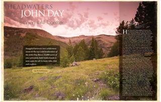
  • 1. Snuggled between two wilderness areas in the icy-cold headwaters of the John Day River, 13,000 acres of once privately held timberlands is now open for all to hunt, hike, fish and explore. JOHNDAY H igh along the ridges south of Prairie City in northeast Oregon, the John Day River is born. Hundreds of tiny springs and rivulets of snowmelt trickle down hillsides as they weave their way through elk summer range. The creeks pass through decades-old clearcuts thick and green with two-story-tall lodgepoles—perfectly square sections of once privately managed timberlands. Without warning, the creeks hit a wall of old-growth spruce with live, dead and dying trees—640-acre sections of public land managed by the US Forest Service. For some creeks, this boundary hopping goes on for miles. By the time the water nears County Road 62, the creeks have merged to become the John Day River, meandering through ponderosas and knee-high grass. It’s a good place to be an elk, but it’s a management nightmare of checker-boarded public and private land—at least that’s how it used to be. Under a blue spring sky, I ride shotgun with Bill Richardson, RMEF lands program manager (LPM) for Oregon and Washington. From the road above the John Day, he points out far ridges where some 20 years ago he and a friend drove where only a Land Cruiser could go. We don’t go there today in his Dodge, but we do turn off the pavement and inch our way to a spot he’s picked out. We pass two open gates, and with each fork in the road the trees close in. Overhanging limbs screech along the doors. “Redneck pinstripes,” Bill says with a grin. Finally, a tree hangs across the road. I get the feeling Bill goes few places without his Stihl chainsaw with a 32” bar. Firewood grows big where he lives in western Oregon. The whine of the saw breaks the stillness for only a moment. We climb again until the ridge flattens out and park under several old, sagging meat poles. In front of a stand of ponderosa pines sits a knee-high memorial for a son and a father: “Whose favorite season was elk,” it reads. This was a family’s elk camp. I can see why they liked it here. Finger ridges jut every cardinal direction. You can hunt up or down, whatever suits your mood and the prevailing thermals. Not far away, you can summit a peak covered in talus and glass the drainages in one Bringing It All Together by PJ DelHomme 62 • BUGLE • NOV/DEC 2014 NOV/DEC 2014 • BUGLE • 63
  • 2. a bow. “I saw some bulls in the 350-class or better, but they were all on private land. It seems those bulls hang out in the wilderness until snow or hunting pressure causes them to beeline it down to the private ranches below. The key is timing it so you catch them in the transition, which includes some of the Headwaters project area.” Justin Karnopp grew up in Oregon and hunted that area with his family in the early 1990s (see his story on page 44). They would base camp just outside the Strawberry Mountain Wilderness and then hike in, which is a good strategy given the area’s popularity. “There are lots of bowhunters, and you really have to hike to get away from them and into the elk, which are educated, especially during bow season,” says Karnopp. One good way to ditch the crowds is to take advantage of a three-week-long traditional archery-only (long or recurve bows) season in a portion of Unit 46 called Canyon Creek. And while Karnopp is a die-hard elk hunter, it’s not the bugling bulls that would keep him up at night in camp. The thick woods and folklore of the area has more than a couple tales of the unexplainable. “That’s sasquatch country, man,” says Karnopp. “It’s a place where things go bump in the night.” Sink or Swim Bigfoot stories aside, the area has seen its share of spooky moments, most recently when America’s housing bubble burst in the late 2000s. The housing market reached its peak in 2006. A short while later, market prices started to tank, and people were looking to unload their investment property before it hit rock bottom. And no one knew how low that would actually be. Hired by the RMEF in 2009, Bill Richardson had heard through the grapevine that 23 sections of land belonging to a family-owned timber company were going up for sale. Realtors, sporting property companies and neighboring ranches all had interest. Based on the track record of surrounding lands, the threat of development was very real. In fact, private development along the edges of public land in Oregon and Washington more than doubled since the 1970s, according to a study by the US Forest Service Pacific Northwest Research Station. These parcels were gems, and a number of them had ideal building sites with access roads and gates already established. Yet the family that owned the property was reluctant to let it go. The D.R. Johnson Lumber Company, based in southwest Oregon, owned the sections that owner Don Johnson first purchased back in 2001. The land had been heavily logged by Crown Pacific in the early 1990s, but in a move common in the timber industry, Don bought the land aiming to sell or trade it for other ready-to-log timberlands. He passed away, though, in 2012, and his family was looking to sell the property. For Richardson, there was no time to ease into his role as LPM with a couple of small projects. “As a new LPM, it was like holy cow, this is awesome right out of the gate,” he says. But the project was hardly a slam dunk. At every turn in the process, the road to completion kept getting narrower, constantly threatening to block further progress. By far, the largest monetary contributor to the success of RMEF’s permanent land protection projects has been the Land and Water Conservation Fund (LWCF)—and the future of that fund is uncertain. Since 1965, royalties from offshore oil and gas drilling have been allocated to the LWCF. At full-funding, the fund is supposed to have $900 million in its coffers to protect key pieces of wild country and safeguard clean water sources. But the fund is always raided for Congressional pet projects; only once has it ever been fully funded. Even so, the fund has contributed more than $62 million to RMEF projects, helping to permanently protect more than 62,000 acres of prime elk country. Since its inception, LWCF has contributed $16 billion to national wildlife refuges, forests, parks, historic and scenic trails, wild and scenic river corridors, national battlefields and monuments, and other federal lands. RMEF's long partnership with LWCF started in 1989 with a $7 million LWCF grant to help the RMEF acquire some of the most vital winter range for Yellowstone’s northern herd. Since then, California’s Cache Creek, Montana’s Iron Mask and Tenderfoot Creek, South Dakota’s Wildcat Canyon and more have all been made possible by money from the LWCF. Most recently, the LWCF contributed $2 million for the John Day Headwaters project. But that could all change next fall. On September 30, 2015, the 50th Anniversary of the creation of the LWCF, it will “sunset” or cease to exist if not re-authorized by Congress. It is imperative that Congress hear from you. No other Congressional program does more to directly benefit elk and their habitat—and elk hunters. Conservation and hunting have always been bipartisan values. Consider calling or writing your member of Congress to express your support for the future of the LWCF and elk country. —PJD NOT ALL SUNSETS ARE PRETTY of two roadless areas nearby, bugling until you get an answer. It’s perfect. The hunting camp sits just inside the public land boundary, and anyone can make camp here. Yet some of the roads we drive bisect what was once private timberland. We pass numerous gates, which easily could be padlocked, barring access to both private and public land beyond. But that’s not how things turned out. Thanks to the efforts of RMEF staff and volunteers, foundations, a willing landowner and government agencies, the RMEF was able to purchase 13,000 acres of private timberland in prime elk country and then transfer that acreage to the Forest Service the same day. The project not only secured public access to the 13,000 acres, it created an unbroken expanse of roughly 51,000 acres of great elk habitat. Some of Oregon’s finest elk country is found in the southern Blue Mountains on the Malheur National Forest. The project area lies within Grant County, which holds the most Boone & Crockett entries for typical Rocky Mountain elk in the state, according to records of the Boone & Crockett Club. The last “Booner” was taken in 1984, and now the area is managed for 15 bulls/100 cows, which produces opportunity and a chance at some quality bulls, says Ryan Torland, Oregon Department of Fish and Wildlife (ODFW) biologist for the John Day country. “Traditionally some good bulls are taken out of that Murderers Creek unit because of the wilderness area and the places they can hide,” he says. Much of the project area sits within the Murderers Creek Unit 46, where archery tags are still over-the-counter and rifle hunters can draw a tag roughly every three years. “There are a ton of elk in the area, but it gets a lot of pressure during archery season,” says Chad Klinkenborg, RMEF’s northern Oregon regional director. He hunted the area last year with a muzzleloader, but says he’s going in next year with The project not only secured public access to the 13,000 acres, it created an unbroken expanse of roughly 51,000 acres of great elk habitat. 64 • BUGLE • NOV/DEC 2014 NOV/DEC 2014 • BUGLE • 65
  • 3. The process took roughly five years. Just getting an appraisal for the property required Richardson to shuttle the appraisers to the 23 sections, totaling 500 miles and five days’ worth of redneck pinstripes. And when the appraisal did come in, it was mighty low, nearing the original purchase price back in 2001. The Johnson family was dismayed, and was ready to walk away from the table, and at times they did. But they came back because that’s what Don would have wanted. “My husband loved the outdoors and hunting,” says JoAnne Johnson, Don’s widow and co-owner of D.R. Johnson Lumber Company. “Don always felt that ultimately blocking up our sections with the Forest Service property made the most sense. It is the family’s hope and desire that now this beautiful and unique area will remain accessible for hunters, fishermen and all outdoorsmen, and that it will receive some much-needed forest management as well. It is a bittersweet moment for us, but we believe Don would want the citizens of Grant County to be able to enjoy this amazing property for generations to come.” The low appraisal wasn’t the only tree in the road. Some county commissioners didn’t like the idea of private land being turned over to the federal government. One argument against the sale was that the county would lose some of its tax base, which is only partly true. While the Forest Service does not pay property taxes on federal land, counties instead receive payments in lieu of taxes (PILT) from the US government that help offset losses in property taxes due to non-taxable federal lands within their boundaries. In 2014, Grant Country received $630,591 for 1.75 million acres of federal land. In 2013, it was $581,458. Because the land in the project area was private timberland, it was taxed at a lower rate than standard property tax. But when timber or agriculture land is taken out of production, being either developed, sold or transferred to the Forest Service, the sellers are subject to a “recapture tax.” In this case, the law calls on the landowner to pay five years’ worth of back property taxes on the land once it is no longer classified as timberland. Ultimately, the county received an additional $265,000 because of the recapture tax. “Some projects are easier than others, but this wasn’t one of the easy ones,” says Jennifer Doherty, the RMEF’s director of lands. “Without Bill’s tenacity, the Johnson family’s patience, and effort from countless other individuals and organizations, this vital chunk of elk country never would have made its way to the public domain.” A Fishery Stronghold The headwaters of the John Day is home to roughly 500 elk from May to September that spend the warmer months following green-up as the snow recedes. The project area is also a key migration corridor. Idaho fescue and mountain mahogany share hillsides with scattered ponderosas, lodgepole and spruce. Very few non-native plants have made inroads here. The elk cross paths with mule deer, mountain goats, black bears and even the occasional wolverine. While the elk and potential victory for hunter access were what first attracted the RMEF to the project, it was the “other wildlife” of the area that helped secure the $7.5 million to purchase the property. Namely, wildlife elk hunters rarely see, hidden beneath the waters of the John Day and its tributaries. Tim Unterwegner, a RMEF Life Member since 1995, spent more than three decades as a fish biologist with the Oregon Department of Fish and Wildlife. He’s lived in John Day for 20 years and spent the last 16 years as finance chair for the RMEF’s John Day Chapter. “That retired fish squeezer had data on all the streams,” says Richardson. “It’s what made the project.” It made the project because the John Day is the longest free-flowing (undammed) river west of the Continental Divide, and the project directly impacted 35 miles of stream in the watershed. The river’s list of native species reads like a who’s who of the threatened and endangered variety. It’s home to the threatened bull trout that spawns in headwater streams. It has one of the largest wild runs of spring chinook left in the Columbia River Basin. It holds Oregon’s only known population of westslope cutthroat trout. And here, threatened summer steelhead have their healthiest run in the Columbia River watershed. “When we work to protect and conserve elk habitat, we really do have to look at the big picture,” Day was a classic mountain man. Born in Virginia in 1770, he trapped and explored the West on the heels of Lewis and Clark. Nowadays, his name is immortalized in a national monument, two Oregon towns, and a dam on the Columbia. Perhaps his best known tribute, though, is the river that now bears his name. In 1811, camped in east-central Oregon where the river the early Native Americans called Mah-hah flows into the Columbia, John Day was robbed. He and a companion were stripped of everything, including the clothes on their backs. A year later, they stumbled into Fort Astoria, more than 300 miles from their unfortunate encounter with the locals. —PJD WHO WAS JOHN DAY? says Bob Springer, RMEF project development specialist. “For the John Day, finding money just to conserve elk habitat and access would have been tough without the tremendous fisheries component, not to mention the area’s sensitive bird and amphibian species.” Those cold spawning streams that start high in the John Day country put this project as the number one funding priority for the Land and Water Conservation Fund (LWCF). That fund alone contributed $2 million toward the purchase. (See sidebar on page 65.) The project also pulled in $500,000 from the National Fish and Wildlife Foundation—Acres for America Program, a program created by Walmart in 2005 to permanently conserve at least one acre of wildlife habitat for every developed acre of Walmart Stores’ current and future footprint. Walmart’s footprint is roughly 138,000 acres, but the program has since impacted 850,000 acres, including the John Day Headwaters project. “I don’t know if you fully realize the impact of the RMEF until you get out on the ground,” says Kevin Sweet, senior director of real estate for Walmart. “If it wasn’t for the RMEF, no one would have stepped in and put this all together. Our first stop on the tour was an overlook where you look down at the valley below. That’s when I got the perspective of what this could have been. That is the prime spot for a million dollar cabin, because it has a million dollar view. From blocking up the land, to conserving the elk and fish habitat, this whole thing is a great story.” The remaining portion of the $5 million came from the RMEF’s Torstenson Family Endowment and a private donor who asked to remain anonymous. The fish that helped net those funds also pump a lot of money into local economies. “We get hundreds of fishermen every season,” says Mia Sheppard, who, along with her husband Marty, has owned Little Creek Outfitters on the John Day for more than a decade. And while they are based out of Condon, 120 miles downstream of the headwaters, what happens in the headwaters has a direct impact on their business. “The summer run of steelhead are very special here. They start stacking up 66 • BUGLE • NOV/DEC 2014 NOV/DEC 2014 • BUGLE • 67 The early stretches of the John Day weave through Oregon's lush elk country.
  • 4. at the confluence of the John Day and the Columbia River in July, but water temps in the John Day are over 70 degrees, which is too hot for them to move upstream,” she says. “They wait for the water to get cold in the fall, then make their way to the upper tributaries to spawn. If the water never gets cold enough, then they move on to another river. It’s a lifecycle; whatever happens in the headwaters happens downstream. Less fish into the river, means less fish into the headwaters to spawn.” Little Creek Outfitters employs seven guides during the steelhead season in the fall, and when fishermen come to town, they bring their checkbooks with them. “They stay two or three nights in local hotels, eat out in town,” Sheppard says. “And we gas up our rigs, buy groceries and pay the mechanic when bearings blow out. We’re supporting the local values of the local ranching community. It’s a way of life here, which has to be balanced with the recreational community.” In 2008 in Grant County alone, travel-related revenues from fishing, hunting and wildlife watching totaled more than $11.5 million, according to a 2008 study. Fishing accounts for $3.2 million, hunting $5.1 million, and wildlife watching $3.1 million. Not every elk hunter likes to wet a line, so why would they care about healthy fish habitat? “It’s no secret that intact headwaters produce the finest quality water and the best habitat for a number of species, including elk,” says Unterwegner. “It’s On August 17, 2012, Malheur Lumber, the last major sawmill in Grant County, was going to close. “The issue was uncertainty,” says Bruce Daucsavage, Ochoco Lumber president. “I wasn’t going to put another nickel into that plant. We just couldn’t find enough profitable wood. We were going to lay off 80 people.” Even though forest supervisors and community members had worked to implement an accelerated forest restoration program on 600,000 acres on the Malheur National Forest after colossal fires in 2000, it wasn’t enough to keep that mill going and the forest healthy. With unemployment rates in Grant County at nearly 13.6 percent in 2012, something needed to happen. After the announcement, Daucsavage was invited to Oregon Senator Ron Wyden’s office. In a week, Daucsavage put together a plan of what the timber industry needed in eastern Oregon to stay alive. At the Senator’s office, the room was packed. At least 50 people attended, including Kent Connaughton, Forest Service Region 6 regional forester. The Senator told Connaughton he had 10 days to propose a solution, says Daucsavage. Huge fires in Idaho were able to keep the mill open with cheap wood while the Forest Service worked to get public comment on their proposed solution. With help from the Blue Mountain Forest Partners and Harney County Restoration Collaborative, the Forest Service expanded the restoration to 1.2 million acres in 2013. The Forest Service awarded a 10-year stewardship contract to Iron Triangle Logging out of John Day. “That commitment we made allowed the mill to remain open,” says Steve Beverlin, Deputy Forest Supervisor on the Malheur National Forest. “The 10-year contract now provides more long-term certainty allowing them to reinvest in their mill. They’ve added another shift and seen their first increase in staffing since 1996. Hope and optimism is growing in the community.” “We are very comfortable that there will be enough material to keep us going 10 more years,” says Daucsavage. “We just hired 30 more employees. For a town of 2,400, that’s a big deal.” The D.R. Johnson family also has two mills in the area: Grant Western in John Day and Prairie Wood products in Prairie City. Both mills, though, are currently idle. With any luck, the new stewardship agreement will get more logs out and help get the mills going again. The collaborative is now a model for forest stewardship across the country. The value of the saw logs pays for the thinning, which feeds the mill and keeps it running. “At times it was difficult to sit through some of the meetings, but friendships have developed with people you otherwise wouldn’t pass the day with,” says Daucsavage. “Trust is so key here,” adds Beverlin. “People here are very open, and they give you their trust. The challenge in front of us is to continue to meet that commitment, be transparent and inclusive and just talk to folks. We want to continue our partnerships. Their livelihood does depend on decisions we make.” —PJD because there is little or no disturbance. There has been some logging in there, but where there is little disturbance, that’s where the elk go. It’s not a sanctuary but it’s good habitat. “I worked the bulk of my career trying to protect the best of the best, in terms of fish and wildlife habitat,” he says. “There were darn few opportunities that came along, and none of them had the potential that this acquisition will provide.” Checkered Past As the West was settled, the US government enticed railroad companies and private entrepreneurs to lay tracks coast to coast by granting the companies every other section of land along the tracks. The same tactic was used to attract builders of military supply roads. The checkboarded squares on the map on page 64 are the remnants of land grants for the construction of The Dalles Military Road, which was supposed to stretch from The Dalles, Oregon, to Fort Boise in Idaho. The road existed on paper but was never actually completed. Public outcry about the unfinished and unmaintained road ensued, but it was too late. The land was in private hands. Those perfectly square sections on the map are easily seen on the ground. Logged openings of early seral (young) forests are directly adjacent to late old-growth forest. And this alternating land ownership has put land managers in a bind. How do you manage a landscape where ownership changes every mile? “It’s very difficult to manage,” says Ryan Torland of ODFW. “When the area was broken up with public and private land, there wasn’t much we could do. How do you stop managing at one section and then pick up at another. Plus, there wasn’t a lot of hunter access. The landowner could post and lock one gate closing off access to the public land behind it.” Now, those 13,000 acres form a solid 51,000-acre span of national forest connecting the Strawberry Mountain Wilderness to the west and the Monument Rock Wilderness to the east. “What we have now is continuity of management,” says Torland. “This acquisition makes it easier to manage because it’s all blocked up. We will need to see what the Forest Service does in terms of travel management, and we’ll work closely with them to make sure deer and elk concerns are up front in the planning process.” Travel and timber management for the area are still up in the air, and the Forest Service is ultimately responsible for opening or closing gates. The Malheur National Forest has many miles of road accessible for public use, says Steve Beverlin, deputy forest supervisor on the Malheur National Forest, but nothing will go forward without public input. “Until the winter of 2014 or spring 2015 we’re going to leave the area as it was before. If a gate was open it will A COOPERATIVE FOREST 68 • BUGLE • NOV/DEC 2014 NOV/DEC 2014 • BUGLE • 69 Mia Sheppard, co-owner of Little Creek Outfitters that guides on the John Day, shows off a beautiful steelhead. PHOTOCOURTESYOFMIASHEPPARD.
  • 5. be open and if it was closed, we’ll leave it closed,” says Beverlin. “We still need to figure out how we want to manage the new 13,000 acres we were fortunate to receive,” he says. “We want to be strategic. We want to move forward slow enough so people can get involved. We want that engagement with the public. We made that commitment to the community long ago. And thankfully we have a ready-made group of people who are interested in the project area already.” Many of those interested in the area helped bring this project together, and throughout the five- year process, at some point or another, they shook hands with the RMEF’s Bill Richardson. Bill and I drive one of those still open roads to his camp high on a saddle that looks directly into the Strawberry Mountain Wilderness. After a day spent touring only a small chunk of the 13,000 acres now protected, we share a meal over a campfire. We watch as the last rays of the sun fade from snow-capped peaks. Glassing openings of young dog-hair-thick lodgepole in the soft light, Bill points out an elk. After 15 minutes of looking, I still can’t make it out. Even so, it’s good to know they’re there. And thanks to this quilt of public and private land now stitched together under one owner—you and me—those elk will be there for many sunsets to come. NOW RMEF MEMBERS ARE REWARDED! Call 1-866-238-1426, visit www.nationwide.com/RMEF or contact a local Nationwide agent today. Only Nationwide® gives RMEF members an exclusive discount on auto insurance. Plus, when you purchase features like Vanishing Deductible®, you can take $100 off your deductible for every year of safe driving, for a total of $500 in savings. Nationwide may make a financial contribution to this organization in return for the opportunity to market products and services to its members or customers. Products Underwritten by Nationwide Mutual Insurance Company and Affiliated Companies. Nationwide Lloyds and Nationwide Property & Casualty Companies (in TX). Home Office: Columbus, OH 43215. Subject to underwriting guidelines, review, and approval. Vanishing Deductible is an optional feature. Annual credits subject to eligibility requirements. Max. credit: $500. Details and availability vary by state. Products and discounts not available to all persons in all states. Nationwide, Nationwide Insurance, the Nationwide framemark and Vanishing Deductible are service marks of Nationwide Mutual Insurance Company. ©2013 Nationwide Mutual Insurance Company. AFO-0749AO (08/13) &