Beginners Guide to TikTok for Search - Rachel Pearson - We are Tilt __ Bright...
2010_APV
1. NI 43‐101 Technical Report, Dominican Republic
Minera Camargo S.A. de C.V. Page | 1
IINNDDEEPPEENNDDEENNTT TTEECCHHNNIICCAALL RREEPPOORRTT FFOORR TTHHEE
AAMMPPLLIIAACCIIOONN PPUUEEBBLLOO VVIIEEJJOO ((AAPPVV)) PPRROOJJEECCTT,,
DDOOMMIINNIICCAANN RREEPPUUBBLLIICC
LLaattiittuuddee 1188ºº5544'',, LLoonnggiittuuddee 7700ºº0066''
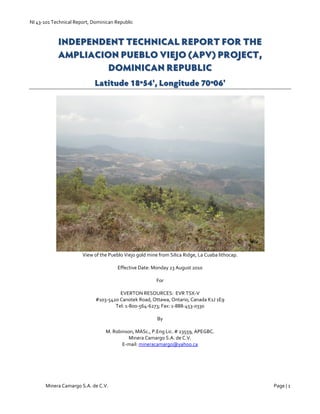
View of the Pueblo Viejo gold mine from Silica Ridge, La Cuaba lithocap.
Effective Date: Monday 23 August 2010
For
EVERTON RESOURCES: EVR TSX‐V
#103‐5420 Canotek Road, Ottawa, Ontario, Canada K1J 1E9
Tel: 1‐800‐564‐6273; Fax: 1‐888‐453‐0330
By
M. Robinson, MASc., P.Eng Lic. # 23559, APEGBC.
Minera Camargo S.A. de C.V.
E‐mail: mineracamargo@yahoo.ca
2. NI 43‐101 Technical Report, Dominican Republic
Minera Camargo S.A. de C.V. Page | 2
Contents
Table of Figures ................................................................................................................................................................. 3
List of Tables ..................................................................................................................................................................... 5
1.0 Summary ..................................................................................................................................................................... 6
2.0 Introduction ................................................................................................................................................................. 7
3.0 Reliance on other experts ............................................................................................................................................. 7
4.0 Property Description and Location ............................................................................................................................... 8
4.1 Essentials of the mining law in the Dominican Republic............................................................................................ 8
4.2 Environmental Permits .......................................................................................................................................... 10
5.0 Accessibility, Climate, Local Resources, Infrastructure and Physiography .................................................................. 10
6.0 History ....................................................................................................................................................................... 11
7.0 Geological Setting ...................................................................................................................................................... 12
7.1 Regional Geology ................................................................................................................................................... 12
7.2 Property Geology ................................................................................................................................................... 13
7.2.1 Maimón Formation ......................................................................................................................................... 13
7.2.2 Los Ranchos Formation ................................................................................................................................... 14
7.2.3 Hatillo Formation ............................................................................................................................................ 14
7.2.4 Las Lagunas Formation ................................................................................................................................... 15
7.2.5 Peralvillo Formation ........................................................................................................................................ 15
7.2.6 Late Cretaceous to Tertiary diorite/dacite intrusions ....................................................................................... 15
8.0 Deposit Types ............................................................................................................................................................ 18
8.1 Volcanogenic massive sulfide deposits ................................................................................................................... 18
8.2 Porphyry copper systems ....................................................................................................................................... 19
8.3 Epithermal gold deposits ....................................................................................................................................... 20
9.0 Mineralization ............................................................................................................................................................ 21
9.1 Tres Bocas gold‐rich VMS prospect ........................................................................................................................ 21
9.2 Cuance gold‐rich VMS prospect ............................................................................................................................. 22
9.3 Los Hojanchos ........................................................................................................................................................ 24
9.4 La Lechoza (VMS?) ................................................................................................................................................ 26
9.5 La Cuaba Lithocap ................................................................................................................................................. 28
10.0 Exploration ............................................................................................................................................................... 32
10.1 Airborne Geophysical Surveys .............................................................................................................................. 32
10.2 Soil Geochemistry ................................................................................................................................................ 36
10.3 Rock Geochemistry .............................................................................................................................................. 38
10.4 Lithocap Alteration Study using a PIMA SWIR spectrometer ................................................................................ 39
11.0 Drilling ...................................................................................................................................................................... 42
3. NI 43‐101 Technical Report, Dominican Republic
Minera Camargo S.A. de C.V. Page | 3
11.1 Percussion Drilling ................................................................................................................................................ 42
11.2 Diamond Drilling .................................................................................................................................................. 43
12.0 Sampling Method and Approach .............................................................................................................................. 45
12.1 Soil Samples ......................................................................................................................................................... 45
12.2 Rock Samples ....................................................................................................................................................... 46
12.3 Percussion Drill Samples....................................................................................................................................... 46
12.4 Diamond Drill Samples ......................................................................................................................................... 46
13.0 Sample Preparation, Analysis and Security ............................................................................................................... 47
13.1 Soil samples .......................................................................................................................................................... 47
13.2 Percussion drill samples ........................................................................................................................................ 47
13.3 Rock and core samples: ........................................................................................................................................ 47
14.0 Data Verification ...................................................................................................................................................... 48
15.0 Adjacent Properties .................................................................................................................................................. 49
15.1 Pueblo Viejo ......................................................................................................................................................... 49
15.2 Cerro de Maimón .................................................................................................................................................. 50
16.0 Mineral Processing and Metallurgical Testing ........................................................................................................... 51
17.0 Mineral Resource Estimates ...................................................................................................................................... 51
18.0 Other Relevant Data and Information....................................................................................................................... 51
19.0 Interpretation and Conclusions ................................................................................................................................. 51
20.0 Recommendations ................................................................................................................................................... 52
21.0 References ............................................................................................................................................................... 55
Certificate of Author ........................................................................................................................................................ 58
Appendix 1: Abbreviated listing of surface rock data ........................................................................................................ 59
Appendix 2: Abbreviated listing of Core Samples ............................................................................................................. 61
Appendix 3: Assay certificates for surface rock samples and six ¼ core check samples ......... Error! Bookmark not defined.
Table of Figures
Fig. 4.1 Concession map of the Property. ........................................................................................................................... 9
Fig. 7.1 Regional Geological Map of the Island of Hispaniola ............................................................................................ 13
Fig. 7.2 Geological Legend ............................................................................................................................................... 17
Fig. 7.3 Geological compilation map of the Property ........................................................................................................ 17
Fig. 8.1 Essential characteristics of an idealized gold‐rich volcanogenic massive sulfide deposit.. .................................... 19
Fig. 8.2 Essential characteristics of a porphyry copper system ......................................................................................... 20
Fig. 8.3. Generalized alteration‐mineralization zoning pattern for porphyry copper deposits (from Sillitoe, 2010). .......... 20
Fig. 9.1 Cross‐section through Tres Bocas ........................................................................................................................ 22
4. NI 43‐101 Technical Report, Dominican Republic
Minera Camargo S.A. de C.V. Page | 4
Fig. 9.2 Cross‐section through Cuance ............................................................................................................................. 24
Fig. 9.3 Cross‐section through Los Hojanchos .................................................................................................................. 26
Fig. 9.4 Cross‐section through La Lechoza, North Hill ...................................................................................................... 28
Fig. 9.5 Cross‐section through La Cuaba .......................................................................................................................... 29
Photo 9.1. TRES BOCAS. Rare surface outcrop of quartz‐kaolinite schist ......................................................................... 30
Photo 9.2. TRES BOCAS. Photograph of banded massive sulfide ..................................................................................... 30
Photo 9.3. CUANCE. Rhyolite lapilli tuff in the hanging wall to the Cuance VMS prospect. .............................................. 30
Photo 9.4 CUANCE. View of the Cuance VMS horizon .................................................................................................... 30
Photo 9.5 CUANCE. Sample 167239 ................................................................................................................................ 30
Photo 9.6. CUANCE. Photomicrograph of sample 167282 ............................................................................................... 30
Photo 9.6. LOS HOJANCHOS. Quartz veinlets with red Fe‐oxide. .................................................................................... 31
Photo 9.7. LOS HOJANCHOS. YAM PIT – site of Pan Ocean DDH. ................................................................................. 31
Photo 9.8 LA LECHOZA. Ferruginous gossan at Spanish Pit. ........................................................................................... 31
Photo 9.9 LA LECHOZA. Ferruginous gossan at North Hill. .............................................................................................. 31
Photo 9.10 LA LECHOZA. Sample 311079 from APV 10‐02 .............................................................................................. 31
Photo 9.11 LA LECHOZA. Sample 311516 from APV 10‐07 .............................................................................................. 31
Photo 9.12 LA LECHOZA. Photomicrograph of sample 311268 ........................................................................................ 32
Photo 9.13 LA LECHOZA. Photomicrograph of sample 313262, APV 09‐15, 70‐71.2 m. .................................................... 32
Photo 9.14 LA CUABA. Silica and goethite matrix breccia ............................................................................................... 32
Photo 9.15 LA CUABA. Sample 36243, APV 04‐08, 176‐178 m. ....................................................................................... 32
Fig.10.1 Gridded airborne magnetic data ......................................................................................................................... 34
Fig.10.2 Map of amplitude of dB/dt Z channel 9. .............................................................................................................. 35
Fig. 10.3 Soil anomaly map for Loma El Mate, Los Hojanchos and Cuance. ...................................................................... 37
Fig. 10.4 Soil anomaly map for La Lechoza. ..................................................................................................................... 38
Fig. 10.6. Cross‐section through La Cuaba Lithocap. ....................................................................................................... 42
Photo 11.1. AIRTRACK DRILL. .......................................................................................................................................... 44
Photo 11.2. MAN PORTABLE DRILL RIG .......................................................................................................................... 44
Fig. 11.1 Drill collar location plan. ..................................................................................................................................... 45
Photo 15.1. PUEBLO VIEJO. Argillic altered Zambrana rhyolite dome. ............................................................................ 50
Photo 15.2 PUEBLO VIEJO. Photo of laminated massive sulphide protore ....................................................................... 50
Photo 15.3 PUEBLO VIEJO. Fairly flat lying carbonaceous quartz‐crystal tuff. ............................................................... 50
Photo 15.4 PUEBLO VIEJO. View of sub‐vertical diorite dike. .......................................................................................... 50
Fig. 20.1 Exploration diamond drilling plan . ................................................................................................................... 54
5. NI 43‐101 Technical Report, Dominican Republic
Minera Camargo S.A. de C.V. Page | 5
List of Tables
Table 4.1 Summary description of the APV Project Exploration Concessions. .................................................................... 8
Table 9.1 Drill intercepts from Tres Bocas. ....................................................................................................................... 21
Table 9.2 Drill intercepts from Cuance. ............................................................................................................................ 23
Table 9.3 Drill intercepts from Los Hojanchos. ................................................................................................................. 25
Table 9.4 Drill intercepts from La Lechoza. ...................................................................................................................... 26
Table 9.5 Drill intercepts from La Cuaba. ......................................................................................................................... 29
Table 10.1 Summary distribution statistics for 8576 soil samples. ..................................................................................... 36
Table 10.2 Summary distribution statistics for 3974 rock samples. ................................................................................... 39
Table 12.1 Types of rock samples used to evaluate mineral occurrences on the Property. ............................................... 46
Table 14. 1 Repeat ¼ core samples. ................................................................................................................................. 49
Table 20.1 Summary of proposed Phase 1 Exploration Expenditures ................................................................................ 53
Table 20.2 Summary of proposed Phase 2 Exploration Expenditures ............................................................................... 53
6. NI 43‐101 Technical Report, Dominican Republic
Minera Camargo S.A. de C.V. Page | 6
1.0 Summary
The Ampliación Pueblo Viejo (APV) Project is comprised of five contiguous mineral concessions totaling 16810 Ha
centered 10 kilometers south of the city of Cotuí, in the central portion of the Dominican Republic, Island of Hispaniola,
northern Caribbean Sea (Fig. 4.1). Four of the concessions are 50% owned and operated by Everton Minera Dominicana
S.A., the Dominican subsidiary of Everton Resources (“Everton”). Joint venture partner Globestar Mining owns 50% of
two of the concessions (Cuance and Los Hojanchos), and Linear Gold owns 50% of two other concessions (La Cueva and
Ampliación Pueblo Viejo). Everton owns 100% of one concession (Jobo Claro). The APV concessions surround the Pueblo
Viejo gold deposit in all directions except south. Past production from Pueblo Viejo is estimated at 27 million tonnes of
oxide ore averaging 4.23 g/t Au and 21.6 g/t Ag (Kesler et al., 1981). The latest published reserve estimate for Pueblo
Viejo is 248.6 million tonnes of ore grading 2.8 g/t Au, 13.4 g/t Ag, 0.56% Zn and 0.08% Cu (measured and indicated
categories at a 1.4 g/t Au cut‐off grade; Smith et al., 2008). Partners Barrick Gold Corporation and Goldcorp Inc. are
currently constructing an open‐pit mining complex on the site (cover photo). Current plans are to have the mine in
production by the end of 2011 (Barrick Gold Corporation Annual Report, 2009).
The concessions overlap part of the Los Ranchos and Maimón Formations. Los Ranchos Formation represents the
remnants of an Early Cretaceous axial primitive island arc, and Maimón Formation represents the fore‐arc volcano‐
sedimentary basin. These rocks are overlain by Hatillo Formation limestone, La Laguna argillite, and deformed by thrust
faulting. Finally, they are cross‐cut by Late Cretaceous to Tertiary diorite plutons.
Two ages of mineralization are thought to occur on the Property: (i) syn‐depositional volcanogenic massive sulphide
(VMS) deposits of Early Cretaceous age in the Los Ranchos and Maimón Formations, and (ii) epigenetic gold vein deposits
that are probably related to an unexposed Late Cretaceous or Tertiary porphyry copper‐gold system. On Everton’s
Property such a porphyry might be centered below La Cuaba lithocap, an eroded zone of quartz‐pyrophyllite (advanced
argillic) alteration that was originally about 1000 meters thick, and is typical of the upper parts of porphyry copper
systems (Sillitoe, 2010). The lithocap is centered on a complex magnetic anomaly about 3.5 kilometers across that might
mark the location of the causative porphyry intrusion in the sub‐surface. Pueblo Viejo is a giant gold deposit, and about
40% of giant deposits are intrusion‐centered (Hedenquist and White, 2005). Another factor that probably contributed to
the unusual size of Pueblo Viejo is that the gold‐bearing veins cross‐cut a layer of rocks rich in syn‐sedimentary sulfides
and biogenic carbon (Pueblo Viejo Member; Fig. 15.2). Both sulfides and carbon will react with any gold in solution and
cause it to precipitate into the rock (Kesler et al., 1981).
North and west of Pueblo Viejo, several VMS prospects have been identified on the APV project: (i) La Lechoza, (ii)
Cuance, (iii) Los Hojanchos and (iv) Tres Bocas. Of these, La Lechoza is the best defined, and there is near‐term potential
to develop a polymetallic resource there with additional drilling down dip of the known intercepts. However, the most
compelling VMS story is the zoned but untested geochemical anomaly in the area of historic Pan‐Ocean drill holes at Los
Hojanchos. In this area, anomalous zinc and copper geochemistry defines an area about 2 kilometers long and 1.3
kilometers wide, with copper‐rich geochemistry occurring to the northeast (in the footwall), and zinc‐rich geochemistry
below a basalt flow in the hanging wall (Figs. 9.3 and 10.3).
Everton is in the process of exploring the Property and has completed 16044.63 meters of drilling in 141 diamond drill
holes, 2192 line kilometers of helicopter‐borne magnetic and electromagnetic geophysical surveys, several ground
geophysical and geochemical surveys, and short‐wave infrared (SWIR) mineral determinations for 1995 surface rock
samples and 665 core samples from La Cuaba lithocap. Some of the better diamond drill intercepts include: (i) 0.6 g/t Au,
48 g/t Ag, 0.9% Cu and 0.8% Zn across 21 m (APV 10‐07; La Lechoza), (ii) 0.3 g/t Au, 19 g/t Ag, 0.2% Cu and 3.1% Zn
across 22.3 m (TBM‐26; Tres Bocas), and (iii) 1.1 g/t Au, 3 g/t Ag, 0.3% Cu and 2.0% Zn across 18 meters (CUA‐04;
Cuance).
Everton Minera Dominicana’s core business plan for 2010‐2012 is twofold: (i) drill through the lithocap and explore for on‐
strike and down‐dip extensions to Pueblo Viejo as that could be where the highest potential value of the Project is
located, and (ii) explore and expand the known VMS mineralization elsewhere on the Property, mainly by drilling. The
Budget allows for the use of a D‐6 tractor to build access roads and drill pads, although it may be easier from a permitting
perspective to use a man portable drill in some locations. Overall, two phases of exploration drilling are planned. The
first phase consists of 11 280 meters of drilling in 76 holes, with a maximum hole depth of 450 meters. Overall Phase 1
7. NI 43‐101 Technical Report, Dominican Republic
Minera Camargo S.A. de C.V. Page | 7
costs are estimated to be $4.0 million USD (Table 20.1). The second phase of drilling consists of 18 035 meters of drilling
in 43 holes, with a maximum hole depth of 900 meters. The decision to attempt the deeper holes through the lithocap
depends on the results of the first phase of drilling. Alternatively, the Phase 1 results might justify upgrading one of the
prospects to an NI 43‐101 compliant mineral resource estimate. Overall, Phase 2 costs are estimated to be about $6.0
million USD (Table 20.2).
2.0 Introduction
Minera Camargo S.A. de C.V. ("MCA") was retained by Marc L’Heureux of Everton Resources ("EVR: TSX‐V") to conduct
an independent technical review and to prepare a report in compliance with National Instrument 43‐101 ("NI 43‐101") on
the Ampliación Pueblo Viejo Project ("the Property") in the central Dominican Republic. The review is required by the TSX
Venture Exchange as part of the documentation required for financing the Project.
The author has reviewed all of the technical information provided by Everton Resources. Sources of data include:
A Technical Report by Geo‐Habilis Consultants Inc. dated September 2006.
Several internal Technical Reports.
Geochemical data for 3989 rock samples and 8576 soil samples.
Magnetic and electromagnetic data from a 2192 line kilometer helicopter airborne geophysical survey flown
over the Property by Fugro Airborne Surveys in 2007.
Maps for ground geophysical surveys.
Drilling Logs for 16044.63 meters of drilling in 141 diamond drill holes as well as assays for 8305 drill‐core
samples.
SWIR mineral determinations for 1995 surface rock samples and 665 core samples from La Cuaba lithocap.
52.9 gigabytes of information in 72,829 electronic data files.
A 5 day field inspection was carried out by the author between 20 and 24 April 2010 in the company of Ing. H. Dominguez,
Ing. Carlos Carrasco and Everton Minera Dominicana support personnel. The author collected 34 rock chip samples, 6
repeat ¼ core samples and 113 small half‐core samples to verify the general tenor of the mineralization and characterize
the alteration mineralogy. Structural measurements were collected at all measurable outcrops, and some drill‐hole collar
locations were confirmed. An inspection of different locations on the recently completed soil grid was also completed,
and the author has walked parts of this grid to ensure that sample locations are correctly reported and that appropriate
material was sampled.
In Minera Camargo’s laboratory, the rock and core samples were scanned using a Niton GOLDD XRF analyzer, and
Terraspec SWIR spectrometer, as well as visually inspected using a Meiji binocular microscope. Magnetic susceptibility
was measured with a Kappa magnetic susceptibility meter. Petrographic descriptions and analytical results were
recorded (Appendices 1 and 2). Alteration assemblages were classified according to Gifkins (2005) for rocks from
volcanogenic massive sulfide (VMS) prospects and according to Hauff (2005) for unclassified or epithermal vein
prospects. The rock samples were then re‐packaged and sent to ACME Analytical Laboratories in Guadalajara for Au fire
assays and ICP multi‐element analysis (Groups 1DX, Group 6 and Group 7; Appendix 3).
Drill hole data and surface geological plans from Everton’s database were not consistent. In order to present the Property
geology and the geological context of the mineralization in Sections 7, 8 and 9, Minera Camargo drafted a new geological
compilation map (Figure 7.2) using: (i) our own surface observations, (ii) all geological information from the drill hole logs,
(iii) Everton’s rock sample observations, (iv) Everton’s mapping, and (v) government Sysmin geological maps as well as
information from Childe (2000), Holbek and Daubney (2000), and Lewis et al. (2000).
3.0 Reliance on other experts
It was not within the scope of this report to examine in detail or to independently verify the legal status or ownership of
the Property. Everton Resources has not provided copies of title documents, Option Agreements or payment receipts.
The author has reviewed the material regarding some of the land tenure obligations available on the Company website
and on SEDAR, and has no reason to believe that ownership and status are other than as has been represented, but
determination of secure mineral title is solely the responsibility of Everton Resources.
8. NI 43‐101 Technical Report, Dominican Republic
Minera Camargo S.A. de C.V. Page | 8
4.0 Property Description and Location
The Ampliación Pueblo Viejo (APV) Project is comprised of five contiguous mineral concessions totaling 16810 Ha
centered 10 kilometers south of the city of Cotuí, in the central portion of the Dominican Republic, Island of Hispaniola,
northern Caribbean Sea (Fig. 4.1). The concessions are operated by Everton Minera Dominicana S.A., the Dominican
subsidiary of Everton Resources.
Table 4.1 Summary description of the APV Project Exploration Concessions.
Property Owner Resolution
(Mining title)
Expiry Area
(Ha)
Everton Interest
Ampliación Pueblo Viejo
II (APV)
Linear Gold Caribe
1
S.A. IX‐09 April 7, 2014 4045 Joint Venture with Linear Gold to
earn up to 65%.
2
Jobo Claro II Everton Minera
Dominicana, S.A.
In progress
5
Approx. 2012 5030 100%. Purchased from Jose A
Bencosme 6 Aug 2007.
La Cueva (formerly
Loma El Mate)
Linear Gold Caribe
1
S.A. XII‐07 13‐Dec‐12 3395 50% Joint Venture with Linear Gold.
4
Los Hojanchos Corp. Minera
Dominicana
3
In progress
(?)
6
Approx. 2012 2400 50% Joint Venture with Globestar
Mining
Cuance Corp. Minera
Dominicana
3
LXXXVIII‐06 10‐Apr‐11 1940 50% Joint Venture with Globestar
Mining
TOTAL 16810
1
Linear Gold Caribe S.A. is a 100% subsidiary of Linear Gold Corp (now Brigus Gold Corp.).
2
The Company can earn an undivided 50% interest in the APV Concession from Linear Gold by making cash payments totalling US$700,000, performing
minimum Work of US$2,500,000 and issuing 1,200,000 Everton common shares over a three‐year period. The Company can acquire a 65% interest in
the concession by incurring all additional expenditures on the concession to the completion of a bankable feasibility study and by paying Linear
US$2,000,000 and issuing 1,000,000 additional Everton common shares.
3
Corporacion Minera Dominicana S.A. is a 100% owned subsidiary of Globestar Mining.
4
Since December of 2005, a 50% joint venture has been enforced by the partners. The joint venture is participatory with a dilution clause ultimately
leading to a 2% NSR when participation drops below 10%. Everton is the current operator of the joint venture.
5
On 4 March 2010 the five year term of the original Jobo Claro concession expired. A re‐application was submitted 1 March 2010 to the Dirección
General de Minería.
6
Corporacion Minera Dominicana S.A. has re‐applied for this concession, and the abstract of the application has been published.
4.1 Essentials of the mining law in the Dominican Republic
Important components of mining law (Ley 146, 1974) are:
Filing of an application involves two publications in a Dominican newspaper and the annual payment of fees.
All mining titles are to be delivered to a Dominican Republic company. Exploration titles may also be delivered
to individuals or a foreign company, with certain exceptions (e.g. government employees or their immediate
relatives and foreign governments).
Resolutions granting mineral title are issued by the Secretaría de Estado de Industria y Comercio (currently
Ministry of Industry and Commerce) following a favorable recommendation by the Dirección General de Minería.
A company may have exploration and mining titles over a maximum of 30,000 hectares. An exploration title is
valid for 3 years and may be followed by two one‐year extensions. At the end of the 5‐year period, the owner of
the title applies for an exploitation permit, or a new round of exploration permitting may be started at the
discretion of the mining department.
An agreement must be reached with surface rights owners (formal or informal) for each phase of exploration
work. If mining is envisioned, land must be bought. A procedure exists in which government mediation is used to
resolve disagreements, and this process may ultimately end in expropriation at a fair price.
Legal descriptions of exploration and mining concessions are based on polar co‐ordinates relative to a surveyed
monument. The monument location is defined in UTM co‐ordinates, NAD27 datum. The concession boundaries are not
marked or surveyed.
9. NI 43‐101 Technical Report, Dominican Republic
Minera Camargo S.A. de C.V. Page | 9
Fig. 4.1 Concession map of the Property showing producing mines Pueblo Viejo and Cerro de Maimón (bold), mineral prospects (pink) and diamond drill
intercepts (red). Traverses made by the author are in grey. Red hatch shows the Loma La Cuaba lithocap. UTM NAD27 co‐ordinates are used (Zone 19).
10. NI 43‐101 Technical Report, Dominican Republic
Minera Camargo S.A. de C.V. Page | 10
4.2 Environmental Permits
Important components of environmental law (Ley 64‐00, 2000) are:
An environmental permit is not necessary to conduct geological mapping, stream sediment, sampling, line
cutting or geophysical surveys.
A letter of no objection (Carta de no objección) from the Ministry of Environment is all that is required for
trenching and initial drilling, as long as access routes need not be constructed. This letter is based on a brief
technical description submitted by the company.
Additional drilling and the construction of any access roads warrant an environmental license that is valid for one
year. A report must be filed by the company and must include technical and financial aspects that take into
account remediation costs.
At the feasibility stage, an environmental impact study must be submitted and approved by the government.
Minera Camargo has not reviewed, nor has any opinion on the status of Everton Minera Dominicana’s environmental or
social permits. Most of the drilling has been completed using low‐impact, man portable drills, and no significant land
disturbance or pollution of any type was observed in the field. Most of the historic drill‐sites have been re‐vegetated, and
the only evidence for the holes are field markers (cement caps, drill pipe etc.). Local workers have been involved in past
exploration programs, and all of the people that the author talked to look forward to more work.
5.0 Accessibility, Climate, Local Resources, Infrastructure and
Physiography
The Dominican Republic has three major highways are DR‐1, DR‐2, and DR‐3, which go to the northern, southwestern,
and eastern parts of the country, respectively. Access in the Property area is via a system of all‐weather country roads
used by local cattle ranchers and farmers which branch off of Highway DR‐1. The Capital city of Santo Domingo is
located about 140 kilometers to the south of the Property. Modern deep‐water port facilities are located near Santo
Domingo, and Barrick Gold is currently upgrading Highway DR‐1 for the purpose of transporting materials to the Pueblo
Viejo mine site. The nearest major population center is Cotuí (Fig. 4.1).
The majority of the country has access to electricity. Household and general electrical service is delivered at 110 volts
alternating at 60 Hertz. However, electric power service has been unreliable since 1963, and as much as 75% of the power
generating equipment is more than fifty years old. Some areas have power outages lasting as long as 20 hours a day.
Many of the generating companies are undercapitalized and at times are unable to purchase adequate fuel supplies.
The Property is located in the eastern foothills of Cordillera Central at elevations ranging from 100 to just over 500
meters. The Yuna River flows northwest of the Property, and is dammed by the Hatillo Dam. The average annual
temperature hovers around 25°C (77°F), and the average rainfall in the Property area is about 1850 mm per year. The
Dominican Republic, like most of the Caribbean, is located in an area where hurricanes occur, mainly from the beginning
of June to the end of November.
Major earthquakes occur on the island of Hispaniola about once every 50 years. Currently, there is a heightened
earthquake risk on the Septentrional fault zone, which cuts through the highly populated region of the Cibao Valley north
of the Project area. In addition, the geologically active offshore Puerto Rico and Hispaniola trenches are capable of
producing earthquakes of magnitude 7.5 and higher. Earlier this year (12 January 2010), there was a magnitude 7.0
earthquake centered approximately 25 kilometers WSW from Port‐au‐Prince, Haiti at a depth of 13 kilometers on the
Enriquillo‐Plantain Garden fault system which traverses the southern margin of the Dominican Republic. Refugees from
Port‐au‐Prince have been migrating to the Dominican Republic since the date of the disaster.
The economic base of the Property area is mainly agriculture and cattle ranching. Vegetation mainly consists of crops
and grasses. South of Cuance, submontane rain forest occurs in non‐cultivated areas. Crops include sugarcane, coffee,
cocoa, tobacco, bananas, rice coconuts, cassava, tomatoes, pulses, dry beans, eggplants and peanuts. Mining is an
increasingly important economic activity, and Barrick Gold’s Pueblo Viejo mine currently employs about 3500 workers.
11. NI 43‐101 Technical Report, Dominican Republic
Minera Camargo S.A. de C.V. Page | 11
6.0 History
There are no significant historic mine workings or past mineral production on the Property. The largest known prospect
is Spanish Pit in the Lechoza prospect area, a hole about 10 meters long and 4 meters wide dug into ferruginous gossan
that may have been excavated in the 1800’s. The mineral potential of the Central Dominican Republic, particularly the
Maimón Formation, was recognized by Bowin (1966); however, most systematic mineral exploration was done by multi‐
national mining companies after Ley‐146 came into effect in 1974.
1977‐1979: Pan Ocean Minerals completed airborne magnetics, regional geochemistry and soil geochemistry. The
program culminated in trenching and 3 shallow drill holes of La Lechoza as well as four diamond drill holes at Los
Hojanchos. Elsewhere in the Belt, Falconbridge found and drilled the volcanogenic massive sulfide deposit at Cerro de
Maimón in 1978.
1980’s: Rosario Dominicana completed soil geochemistry of Loma La Cuaba, airtrack drilling of Loma La Cuaba, and
airtrack drilling of La Lechoza (1426 meters of drilling in 62 holes less than 48 meters deep). They also obtained the rights
to explore the Maimón Formation and completed an airborne geophysical survey (magnetic and electromagnetic) and
produced a 1:25,000 geologic map. Falconbridge conducted regional gossan sampling. The Mines Department collected
soil samples and stream sediment samples and analyzed them for Au, Ag, Cu, Pb, and Zn. Very low frequency
electromagnetic (VLF), magnetic, and time domain induced polarization (IP) surveys were completed on different
prospects. At Cuance, Battle Mountain Gold completed mapping and rock sampling with negative results.
1996‐1998: Sysmin completed 1:50 000 scale geological mapping and stream sediment geochemical surveying for the
Government. Geoterrex re‐interpreted the airborne geophysical data.
1998‐1999: On the Los Hojanchos concession, Falconbridge, then Corporación Minera Dominicana (CMD), completed
1:10,000 scale geologic mapping, sampling of road cuts and trenches (553 samples), a gridded soil survey, an IP survey
(Warne et al., 1999), and a magnetic survey. Four trenches (997 meters) and four diamond drill holes (659.6 meters in LH‐
01 to LH‐04) were also completed. At Cuance, CMD completed prospecting and sampling work.
2001: Falconbridge and Globestar recompiled the data, and re‐interpreted the 1983 airborne geophysical survey. CMD
collected 171 rock samples at Cuance. Newmont Mining won the bid on the tender of the APV Fiscal Reserve, and
completed data compilation, mapping and rock sampling. Newmont decided not to continue working on the APV
concession.
2002: The APV Fiscal Reserve was converted to an exploration concession by presidential decree number 169/02 on 7
March 2002 and granted under special contract to Minera Mount Isa Panamá, S.A. (MIM) on March 25, 2002. MIM
completed soil, rock and stream geochemistry and 154 meters of trenching. The trenching defined a major gold anomaly
of 1.63 g/t Au across 154 m (Dominguez, 2008a).
2003: MIM completed ground IP and magnetic surveys at La Lechoza (10 line km in 5 lines at 300 meter spacing),
Colorado (6 line kilometers in 2 lines at 250 meter spacing) and ground IP only at La Cuaba (12 km in 7 lines at 400 meter
line spacing). They also completed soil and rock geochemistry in the different target areas. Based on the exploration
results, they completed 1521.34 meters of diamond drilling in 8 holes at La Lechoza (LL1 to 8), and 235.55 meters of
drilling in one hole at Colorado (La Cuaba). Everton entered into an option agreement with Globestar on 27 August 2003.
The agreement allowed Everton to earn 50% of Globestar’s interest in the Los Hojanchos, Cuance, and Loma de Payabo
concessions in return for exploration expenditures of US$390,000 per concession for a total of US$1,170,000 over a three
year period. In December of 2003, Everton entered into an agreement to earn 50% of MIM’s interest in the Loma el Mate
concession in return for exploration expenditures of US$500,000 over a two year period and payment of 100,000 shares
upon signing followed by 50,000 shares and US$30,000 on the first anniversary followed by 50,000 shares and US$40,000
on the second anniversary.
2004: Everton completed a second round of 585 meters of drilling in six holes at Los Hojanchos (LH‐05 to 10). MIM
changed its name to Linear Gold Caribe S.A. and completed soil geochemistry at La Lechoza as well as 1540.57 meters of
drilling in six holes on Loma La Cuaba (APV04‐1,3,5,8, 10 and 12). Additional rock sampling was done at Cuance.
2005: Everton completed a regional stream sediment sample survey. CMD and Linear Gold completed two rounds of
stream sediment sampling followed up by mapping and soil sampling of Loma El Mate. TMC Geophysics completed an IP
12. NI 43‐101 Technical Report, Dominican Republic
Minera Camargo S.A. de C.V. Page | 12
survey of Loma El Mate, which was followed up with 1334 meters of drilling in 13 holes. Linear Gold completed 1858
meters of drilling in 18 diamond drill holes at La Lechoza (LE holes).
2006: Everton Minera Dominicana completed 1378 meters of shallow airtrack drill holes on the Jobo Claro concession (JC‐
01 to JC‐96, all less than 32 m deep. Mapping was completed in the Cuance River, and an additional 105 rock samples
were collected. The soil grid on Loma El Mate was extended to the south, and 997 additional samples were collected to
cover the Cuance prospect.
2007: Everton entered into an Agreement with Linear Gold whereby it can earn an undivided 50% interest in the APV
Concession by making cash payments totaling US$700,000, performing minimum Work of US$2,500,000 and issuing
1,200,000 Everton common shares over a three‐year period. The Company can acquire a 65% interest in the concession
by incurring all additional expenditures on the concession to the completion of a bankable feasibility study and by paying
Linear US$2,000,000 and issuing 1,000,000 additional Everton common shares. Everton completed a helicopter borne
geophysical survey on all of its active concessions in the Dominican Republic (Sharp, 2007). On the Jobo Claro concession
it completed 22 line kilometers of Max‐Min ground electromagnetic surveys and 796 meters of diamond drilling in 4 holes
(JCDH holes). On the APV concession, Everton completed 1:10 000 geological mapping, 3665 soil samples, 2229 rock
samples and 201 meters of diamond drilling in two holes on the APV concession (APV holes, central area). At Cuance, 182
meters of hand‐trenching in the central portion of the soil anomaly were completed.
2008: 1003.6 meters of diamond drilling in 8 holes were completed at Cuance (Carrasco, 2008). Everton completed 177.9
meters of drilling in 2 holes at Loma El Mate (TBM 26 and 27). On the APV concession, 38 line kilometers of IP surveys
were completed, and 1:5000 geological mapping was done of selected areas.
2009‐2010: Between 2009 and 2010, Everton completed 3665.76 meters of diamond drilling in 36 additional APV holes
and a systematic alteration study of La Cuaba lithocaps.
7.0 Geological Setting
7.1 Regional Geology
The Dominican Republic and the Greater Antilles in general, are composed of fragments of intra‐oceanic island arc
volcanic rocks. These fragments were probably once part of a single, continuous, southwest‐facing island arc that
formed off the west coast of the Americas and was active from Lower Cretaceous through Eocene time (Nelson, 2004).
In the Dominican Republic, the axial primitive island arc (PIA) is preserved in submarine to locally subaerial volcanic rocks
of the Los Ranchos Formation. Coeval Lower Cretaceous bimodal volcaniclastic rocks of the fore‐arc basin are preserved
in the Maimón and Amina Formations south and west of Los Ranchos. The Los Ranchos Formation is locally overlain by
Albian reef limestones of the Hatillo Formation. These are in turn overlain by black argillites of the Lagunas Formation.
Los Ranchos, Hatillo and Las Lagunas Formations are overthrust by the Maimón Formation. The Maimón Formation is
overthrust by Lower Cretaceous Duarte peridotites which are overlain by submarine (MORB) basaltic rocks of the Upper
Cretaceous Peralvillo Formation (Fig. 7.1). All of the Mesozoic rocks are cross‐cut and overlain by Late Cretaceous to
Tertiary calc‐alkaline arc plutonic, volcanic and sedimentary rocks.
13. NI 43‐101 Technical Report, Dominican Republic
Minera Camargo S.A. de C.V. Page | 13
Fig. 7.1 Regional Geological Map of the Island of Hispaniola (Draper and Gutierrez‐Alonso, 1997)
7.2 Property Geology
7.2.1 Maimón Formation
The Maimón Formation, possibly the oldest stratigraphic unit in the concession area, outcrops in the southwestern corner
of the Loma El Mate concession and underlies most of the Cuance and possibly Los Hojanchos concessions. It is bounded
to the northeast by the Hatillo Thrust Fault and to the southwest by over thrust basalts of the Peralvillo Formation,
forming a zone about 7.5 kilometers wide in the Project area. Based on geological mapping of the San Antonio
concession, centered 12 kilometers southeast of Cuance, Holbek and Daubney (2000) define four lithostratigraphic units
in the Maimón Formation. From the base upwards these are:
1. Lambedera Mafic Unit. This unit is more than 700 meters thick and consists of pillow basalts and basaltic
andesite with variable amount of feldspar, interflow sediments (black argillite) and mafic‐derived volcaniclastic
rocks. The upper contact is overlain by jasper horizons.
2. Parcela Rhyolite. This unit is about 500 meters thick and consists of rhyolite flows and lapilli to ash tuffs. The
volcaniclastic rocks can be intercalated with minor volcanic rocks, jasper horizons and volcanogenic massive
sulfides. Copper‐rich stock work zones also occur in these rocks.
3. Mosquito Argillite. These rocks are 100 meters to more than 900 meters thick and consist of thinly to medium
bedded fine to coarse grained argillites, greywackes and occasionally jasper. Graded bedding, load casts and
flame structures observed by Daubney and Holbeck (2000) imply that stratigraphy is upright, younging to the
south.
4. Leonorita Schist. This is a section of bimodal volcanic rocks on the order of 800 meters thick. The mafic rocks
consist of amygdaloidal flows, and they are intercalated with rhyolite crystal tuffs and inter‐flow sediments. In
general, the grain size of these rocks is smaller than clastic rocks of the Parcela Rhyolite. The Leonorita schist is
characterized by a strong penetrative deformation.
The Maimón Formation has been postulated as a mega shear zone resulting from the hot obduction of the Loma Caribe
serpentinized peridotites as a north verging thrust block (Draper and others 1996). The resulting deformation varies in
14. NI 43‐101 Technical Report, Dominican Republic
Minera Camargo S.A. de C.V. Page | 14
intensity (Draper and Lewis 1991), but in general consists of a well‐defined planar fabric dipping moderately to the SW.
Massive sulfide horizons in the Maimón Formation are easily deformed, and generally occur parallel to the regional
foliation (F1), with a gentle plunge of about 25˚S (Lewis et al., 2000).
7.2.2 Los Ranchos Formation
Los Ranchos Formation represents the axial arc terrane, is penecontemporaneous with the Maimón Formation, and
forms a 17 kilometer wide zone between the Hatillo Thrust and Tertiary limestone platform to the northeast. The Los
Ranchos Formation was been mapped by Martín‐Fernández and Draper in 1998 as part of the SYSMIN mapping project.
From the base upwards, Los Ranchos formation consists of 7 principal members:
1. Cotuí Basalt. This unit is more than 800 meters thick and consists of pillow basalts and basaltic andesite with
variable amount of feldspar, interflow sediments (black argillite) and mafic‐derived volcaniclastic rocks. Drill
holes at La Lechoza mainly intercept Cotuí basalt and intrusive rocks, as well as locally bedded volcanogenic
massive sulfide.
2. Quita Sueño Dacite. This unit is about 600 meters thick and consists of quartz‐feldspar porphyritic dacite flows,
agglomerates and ash‐flow tuffs with local sub‐volcanic sills, dikes and laccoliths. These rocks yield a U‐Pb age
of 116.9 +/‐0.9 Ma (Kesler et al., 2005).
3. The Zambrana tonalite is centered under the Jobo Claro concession and appears to cover an area on the order
of 9 kilometers long by 4.5 kilometers wide. These crystalline rocks have a U‐Pb age of 112.9 +/‐0.9 Ma (Kesler et
al., 2005. Petrographic descriptions are limited to “a siliceous intrusive rock with a propylitic overprint” (sample
313228; Appendix 2). The largest drill hole intercept of tonalite occurs in Hole JCDH‐04 between 130 and 200
meters depth.
4. Meladito Lahar. The Meladito Formation is a fining‐upwards sequence of mud‐matrix supported blocks of
rhyolite, tonalite and basalt at the base that grades upwards into fossiliferous sediments. This unit occurs south
and west of the fossil volcanic edifice that might be currently marked by upper Cretaceous tonalites in the
central part of the Jobo Claro concession. Holes JCDH‐03 and 04 intercepted thick sections of polymict volcanic
breccia with clasts of basalt and tonalite up to 50 cm across.
5. Zambrana Dacitic Ignimbrite. This unit consists mainly of lapilli tuff, breccia and co‐genetic flow domes. The
flow domes at Pueblo Viejo yield a U‐Pb age of 110.9 +/‐0.8 Ma (Kesler et al., 2005). These rocks are mineralized,
and pervasively altered to dickite, kaolinite and other clay minerals (sample 25627; Appendix 1). Zambrana
Ignimbrite is intercalated with minor andesitic volcanics (Platanal andesites??) west of Pueblo Viejo.
6. Pueblo Viejo (PV) Member. This unit consists of quartz crystal rich sediments and abundant black organic
matter. It is the host rock to the volcanogenic massive sulphide protore of the giant Pueblo Viejo gold deposit
(Photo 15.2). In the vicinity of the Monte Negro pit, the Pueblo Viejo Member is pervasively altered to dickite
(sample 25618; Appendix 1). Kesler et al. (2005) report that the rocks contain fossil tree trunks and thin layers of
coal. The Pueblo Viejo member is penecontemporaneous with the Zambrana Dacitic Ignimbrite and the OAE1
anoxic ocean event. All of these characteristics imply that the PV member was deposited in a shallow marine,
restricted basin.
7. La Cuaba Schist (lithocap). West and south of Pueblo Viejo, the rocks are affected by pervasive pyrophyllite
alteration and silica‐iron metasomatism. The alteration is so intense and pervasive that the origin of these
schists is uncertain, but they are thought to be derived from hydrothermally altered Zambrana Dacitic
Ignimbrite and penecontemporaneous Pueblo Viejo Member. Like the Zambrana ignimbrite, La Cuaba schist is
locally intercalated with minor (less than 15%) porphyritic andesitic volcanic rocks.
7.2.3 Hatillo Formation
The Lower Albian Hatillo reef limestone conformably overlies the Los Ranchos Formation, and outcrops intermittently
over a 10 kilometer long area between Piedra Imán and drill hole JCDH‐01, southwest of La Cuaba lithocap. Drill holes
have intercepted more than 195 meters of Hatillo limestone, and the original depositional thickness might have been 400
to 1000 meters (Sillitoe, 2006). The basal 300 meters of the limestone are silicified and partly replaced by high grade
magnetite and hematite ore. In the 1950’s, up to 700 000 tons of iron were mined from the Las Lagunas and Hatillo iron
deposits on the southern and western sides of the Loma La Cuaba lithocap.
15. NI 43‐101 Technical Report, Dominican Republic
Minera Camargo S.A. de C.V. Page | 15
7.2.4 Las Lagunas Formation
The Las Lagunas Formation consists largely of fine grained, laminated, carbonaceous shales intercalated with epiclastic
volcanic derived sediments and minor carbonates (Bowin 1966). This sequence is believed to represent a limited fore‐arc
basin formed related to the overlapping Late Cretaceous to Early Tertiary arc. The rocks of the Las Lagunas formation are
not known to contain any significant mineral occurrences although it is not uncommon to find intervals of syngenetic
sulphides (pyrite) and locally anomalous Cu and Zn values (Domínguez, 2008).
7.2.5 Peralvillo Formation
Pyroxene andesite pillow lavas of the upper Cretaceous Peralvillo Formation outcrop about 9.5 kilometers southwest of
the Cuance concession where they are overthrust onto felsic schists of the Maimón Formation. Trace element
geochemistry indicates that the basalts are of mid‐ocean‐ridge affinity (Childe, 2000).
7.2.6 Late Cretaceous to Tertiary diorite/dacite intrusions
Undeformed mafic intrusions occur as laccoliths, sills, dikes, sub‐volcanic intrusions and extrusive basalts in and
overlapping the Maimón and Los Ranchos Formations. The rocks consist of hornblende, plagioclase feldspar and variable
amounts of magnetite. Drill holes APV09‐05, 06, 07 and 08 all intercept diorite. Diorite dikes and (possibly) cogenetic,
partially emergent (supracrustal) basalts also occur in the Monte Negro (Photo 15.4) and Moore pits at the Pueblo Viejo
gold mine. These rocks are related to development of a calc‐alkaline arc on top of the Early Cretaceous primitive island
arc rocks. They are co‐eval with alunite in quartz veins from the Pueblo Viejo gold mine. Previous mappers had assigned
these basalts to the Los Ranchos Formation, but some textures such as non‐metamorphosed “crumble breccias” might
imply a younger age.
17. NI 43‐101 Technical Report, Dominican Republic
Minera Camargo S.A. de C.V. Page | 17
Fig. 7.3 Geological compilation map of the Property showing mineral prospects and payable diamond drill intercepts (red). Dashed red line shows La Cuaba
lithocap. Solid red lines are open pit mines. Purple dashed line shows location of a magnetic high that may be related to a buried intrusion or magnetite
body. Solid purple lines are areas of high vertical magnetic gradient where the intrusions might come closer to surface. The Maimón Formation outcrops
southwest of the Hatillo Thrust, and Los Ranchos Formation outcrops northwest of the thrust. Grey dots are traverses by the author.
18. NI 43‐101 Technical Report, Dominican Republic
Minera Camargo S.A. de C.V. Page | 18
8.0 Deposit Types
Two ages of mineralization are thought to occur on the Property: (i) syn‐depositional volcanogenic massive sulphide
(VMS) deposits of Upper Cretaceous age, and (ii) epigenetic gold vein deposits that are probably related to an unexposed
Late Cretaceous or Tertiary porphyry copper‐gold system (such a porphyry might be centered below La Cuaba lithocap
within or close to the magnetic high of Fig. 7.3). At Pueblo Viejo, these two ages of mineralization are juxtaposed in the
same location (Photo 15.3). Elsewhere on the Property, VMS deposits hosted in the Maimón Formation occur at Cuance,
Tres Bocas and probably Los Hojanchos. The origin of La Lechoza is uncertain (section 9.4), but it might be a VMS
deposit in the Los Ranchos basalts modified by Late Cretaceous to Tertiary veining. Pueblo Viejo volcanogenic massive
sulphide protore is interlaminated with carbonaceous rocks of Pueblo Viejo Member of the Los Ranchos Formation. The
VMS deposits of the Maimón and Los Ranchos Formations tend to be copper and zinc rich with elevated precious metals
and low lead values. The metal assemblage reflects the fact that they occur in primitive arc (PIA) rocks with low
potassium and lead contents (Childe, 2000).
North‐westerly trending epithermal quartz veins in tension fractures cross‐cut the black shales and volcanic rocks, and
the Pueblo Viejo mine is centered on this structural corridor. Ar‐Ar dating of alunite in some of these veins yields ages
between 77 to 62 Ma, or Late Cretaceous to Early Tertiary (Kesler et al., 1981). This age is co‐eval with other diorite
intrusion on Hispaniola.
8.1 Volcanogenic massive sulfide deposits
Volcanogenic massive sulfide (VMS) deposits share the following characteristics (Gifkins et al., 2005):
VMS deposits are hosted by submarine volcanic and sedimentary rocks.
They are the same age as the host rocks.
Most deposits are hosted in volcaniclastic units between major volcanic formations.
Economic parts of the deposits typically comprise more than 80% (massive) sulfide
Principal ore minerals are pyrite, sphalerite, galena, chalcopyrite and possibly pyrrhotite.
Stringer‐stockwork zones commonly underlie massive sulfides and may carry economic copper grades (Fig. 8.1).
Geochemically, most VMS deposits are characterized by Fe, Cu, Pb, Zn, Ag and sometimes Au and Ba.
Ore metals can be vertically zoned from iron and copper sulfides at the base of an ore lens through to lead and
zinc sulfides on the periphery. Some ore lenses carry significant barite with or above the Pb‐Zn sulfides.
Massive sulfides can grade laterally into distal exhalites characterized by cryptocrystalline quartz, iron oxides,
jasper, manganese oxide and elevated (but usually non‐economic) metal concentrations.
VMS deposits occur above extensive footwall alteration zones that form by hydrolysis of feldspar. Primary
alteration minerals include sericite, quartz, pyrite, and chlorite. In systems with highly acid fluids, kaolinite,
pyrophyllite and even dickite may occur. These minerals are zoned in a systematic fashion from zones of high
fluid flux outwards into less‐altered host rocks (Fig 8.1). In metamorphosed VMS deposits, aluminous alteration
minerals metamorphose to cordierite, andalusite, or kyanite.
The geometry of the footwall alteration zone depends on the competency of the host rocks. In sequences
dominated by flows and domes, fluid flow is focused by sub‐vertical synvolcanic faults, and the alteration zones
are pipe‐like. In contrast, stratabound alteration (mineralized) zones are more commonly developed in
permeable rocks such as tuffs, breccias and sediments, particularly under impermeable cap‐rocks such as sills
(Gifkins et al., 2005).
19. NI 43‐101 Technical Report, Dominican Republic
Minera Camargo S.A. de C.V. Page | 19
Figure 8.1 Essential characteristics of an idealized gold‐rich volcanogenic massive sulfide deposit. (Dubé et al, 2007). Note the position of chlorite alteration is
distal to the clay‐sericite alteration, which occurs in the footwall. In base metal (low sulfidation) VMS prospects, chlorite occurs in the proximal footwall.
8.2 Porphyry copper systems
Porphyry copper systems are defined as large volumes (10 to more than 100 km 3
) of hydrothermally altered rock
centered on intrusive stocks that may also contain skarn, carbonate‐replacement, sediment‐hosted and high sulfidation
epithermal base and precious metal mineralization (Fig. 8.3; Sillitoe, 2010). The majority of the world’s porphyry systems
occur in Tertiary calc‐alkaline batholiths and overlying volcanic chains. The deeper parts of porphyry Cu systems may
contain porphyry Cu +/‐ Mo +/‐ Au deposits of up to 10 billion tonnes in size. Typical hypogene porphyry copper deposits
have average grades of 0.5 to 1.5% Cu, <100 ppm to 400 ppm Mo and trace to 1.5 g/t Au. Large (disseminated) high‐
sulfidation epithermal deposits average 1 to 3 g/t Au, but contain less copper than the underlying porphyry copper
deposits.
Porphyry copper systems share the following characteristics (Sillitoe, 2010):
The main economic hypogene ore minerals are chalcopyrite, bornite, molybdenite, sphalerite, galena, native Au
and electrum. Associated minerals include pyrite and magnetite.
Silicate alteration minerals include: quartz, biotite, K‐feldspar, actinolite, albite, tourmaline, dumortorite,
muscovite, andalusite, pyrophyllite, alunite, clay minerals, epidote and chlorite.
They are spatially associated with porphyritic intrusions.
Porphyry copper systems are localized by deep, crustal‐scale faults which allow for rapid ascent of magmas and
generation of a hydrothermal fluid.
The ore zones of hypogene porphyry copper deposits occur at paleo‐depths ranging from 1 to 5 kilometers.
20. NI 43‐101 Technical Report, Dominican Republic
Minera Camargo S.A. de C.V. Page | 20
Porphyry copper deposits are overlain by extensive lithocaps that may have an area of up to 100 km2
on surface.
The vertical distance between the lithocap and potassic alteration related to the porphyry copper deposit ranges
from 500 to 1000 meters. The lithocap itself might be as thick as 1000 meters.
Advanced argillic alteration preferentially occurs in rocks with a low acid‐buffering capacity such as rhyolite
tuffs. It is less common in mafic rocks as these tend to neutralize acidic solutions.
Above the porphyry copper deposit, the lithocap may be enriched in As, Mo, Te, Bi, W, and Sn.
High sulfidation lode gold deposits can occur in the pyrophyllite zone at the base of the lithocap, and large
disseminated high‐sulfidation gold deposits tend to occur in the quartz‐alunite zone above the pyrophyllite zone
(Fig. 8.3).
Fig. 8.2 Essential characteristics of a porphyry copper system showing a
centrally located porphyry Cu +/‐ Au +/‐ Mo deposit in a multiphase
porphyry stock and its immediate host rocks. High‐sulfidation gold deposits
can occur inside the lithocap environment (from Sillitoe, 2010).
Fig. 8.3. Generalized alteration‐mineralization zoning pattern for porphyry
copper deposits (from Sillitoe, 2010).
8.3 Epithermal gold deposits
Most of the known economic epithermal precious metal deposits occur in Tertiary volcanic rocks, both in arcs and in post‐
arc extensional settings. Important characteristics of epithermal deposits include:
High grades of Au and Ag.
Anomalous concentrations of Sb, As, Hg, Pb, Zn, Cu and other metals.
Ore minerals include native gold, electrum, acanthite, tetrahedrite, ruby silver, sphalerite, galena and
chalcopyrite.
Mineral and metal zoning is significant from base metal‐rich roots to gold rich bonanza zones to silver‐rich zones
above the bonanza zones.
Gangue minerals include quartz, calcite, barite, clay, sericite, chlorite and epidote.
Most known deposits are vetiform, but stockworks, breccias and disseminated deposits also occur.
They are associated with significant alteration zones (“color anomalies”) and lithocaps that are mainly related to
condensation of magmatic vapor.
21. NI 43‐101 Technical Report, Dominican Republic
Minera Camargo S.A. de C.V. Page | 21
Exposure of ore zones is usually poor as the dominant dimension is down‐dip or down plunge of the ore shoot.
The down‐dip extent of ore zones ranges from 200 meters on low sulfidation systems to more than 1200 meters
in intermediate sulfidation systems.
Minerals are deposited in open spaces, and have characteristic textures (e.g. colloform banded and cockscomb
textures are typical).
Alteration mineral assemblages indicate temperatures of deposition between 100 and 300ºC. Typical alteration types
include: (i) proximal propylite, (ii) distal zones of clay alteration and (iii) unmineralized, but related zones of steam‐heated
alteration or “lithocaps”.
Several sub‐classes of epithermal deposits are recognized: (i) low sulfidation, (ii) intermediate sulfidation and (iii) high
sulfidation. Having said that, different classes of deposit may occur in the same camp, and some styles may overprint
earlier styles. High sulfidation epithermal gold deposits tend to occur in the upper parts of porphyry copper systems.
9.0 Mineralization
9.1 Tres Bocas gold‐rich VMS prospect
Tres Bocas is a VMS prospect that occurs on the southern boundary of La Cueva concession with the Cuance concession
approximately 8 km SE of the Pueblo Viejo mine. It has been drill‐tested with 3375 meters of drilling in 38 holes. Payable
intercepts are polymetallic with significant precious metals, and are listed in Table 9.1. The best overall intercept was 1.7
g/t Au, 62 g/t Ag, 1.2% Cu and 6.9% Zn across 19.42 m in Hole TBM‐07, however, core recovery from this drill hole was
poor.
On surface, the mineralized trend is defined by a zone of gossanous float and kaolinite‐altered subcrop approximately
800 meters long and up to 100 meters wide that trends northwesterly (Photo 9.1). Geochemical surveying shows that the
surface trace of the mineralized horizon is perhaps best defined by anomalous gold‐in‐soil results > 200 ppb Au that
coincide with linear, west‐northwest trending IP anomalies as defined by Lambert (2005). Copper‐in‐soil is also markedly
anomalous in the gossan area, but copper is much more widely dispersed than gold.
Massive sulfides consisting mainly of sphalerite and chalcopyrite with pyrite occur in and above quartz‐sericite‐
andalusite schist (samples 19668, 19738, Appendix 3). The occurrence of andalusite (Al2SiO5) is significant as it either (i)
formed from fluids with temperatures in excess of 360˚C, or (ii) it formed by metamorphism of pyrophyllite
(Al2Si4O10(OH)2) or dickite (Al2Si2O5(OH)4). In either case, it would typify the copper‐gold stockwork zone below gold‐rich
massive sulfide as shown in Fig. 8.1. Chlorite‐sericite‐quartz schist seems to be peripheral to, or below, the payable
mineralization associated with the andalusite schists. On surface, andalusite weathers to kaolinite (Al2Si2O5(OH)4; photo
9.1). Finally, the presence of andalusite defines Tres Bocas as a gold‐rich, high‐sulfidation VMS prospect rather than a
low‐sulfidation or “classic” VMS prospect (Dubé et al., 2007).
Southeast of a late fault that appears to have about 110 meters of left‐lateral movement in this area, the surface trace of
the Tres Bocas horizon could be marked by anomalous gold‐in soil geochemistry. Drill holes TB‐01 and TB‐04
successfully intercepted the horizon (Fig. 9.1), but drill holes TBM‐01, TBM‐10 and TBM‐20 were probably collared into
the footwall. The mineralization consists of disseminated sulfide that might represent a Cu‐Au replacement horizon in
permeable tuffs below a basaltic flow or sill (Fig. 9.1; e.g. Gifkins, 2005).
Table 9.1 Drill intercepts from Tres Bocas.
HoleID FROM_m TO_m Interval_m* Ag_ppm Au_ppb Ba_ppm Cu_ppm Mo_ppm Pb_ppm S_pct Zn_ppm
TB‐01 12.19 16.76 4.57 7 191 80 12272 43 39 9 255
TB‐01 39.62 41.15 1.53 4 134 180 758 8 12 8 33600
TB‐02 46.18 47.24 1.06 3 138 180 758 8 20 7 34600
TB‐04 59.79 67.05 7.26 4 479 90 12729 21 8 11 758
TBM‐02 21.34 21.74 0.40 106 1295 <10 24700 41 0 0 13500
TBM‐03 2.00 8.00 6.00 1 1674 93 826 66 0 0 75
TBM‐07 20.20 39.62 19.42 62 1711 14 12353 23 484 9 68498
22. NI 43‐101 Technical Report, Dominican Republic
Minera Camargo S.A. de C.V. Page | 22
HoleID FROM_m TO_m Interval_m* Ag_ppm Au_ppb Ba_ppm Cu_ppm Mo_ppm Pb_ppm S_pct Zn_ppm
TBM‐12 42.67 47.24 4.57 120 1357 13 7484 67 1425 6 80495
TBM‐15 50.90 55.78 4.88 6 150 24 1515 7 467 10 5252
TBM‐19 42.67 47.24 4.57 4 115 93 678 12 0 5 8573
TBM‐23 40.84 47.85 7.01 19 438 76 1338 3 247 2 27781
TBM‐24 36.00 44.20 8.20 65 414 111 3193 31 1419 8 41977
TBM‐26 33.60 55.90 22.30 19 294 101 1859 17 801 4 30702
ppm = parts per million, ppb = parts per billion, pct = percent
*Intercepts are thought to be close to true width as they were largely drilled perpendicular to the orientation of the geological formations.
Fig. 9.1 Cross‐section through Tres Bocas, looking northwest. The zone intercepted in these holes might be a Cu‐Au alteration zone in permeable tuffs below
a relatively impermeable basalt cap.
9.2 Cuance gold‐rich VMS prospect
Cuance is a gold‐rich VMS prospect that is well‐centered in the Cuance concession approximately 12 km SE of the Pueblo
Viejo mine. It has been explored with 1003.6 meters of drilling in 8 holes in late 2007 and 2008 (Carrasco, 2008). Payable
intercepts are polymetallic with significant precious metals, and are listed in Table 9.2. The best overall intercept was 1.1
g/t Au, 3 g/t Ag, 0.3% Cu and 2.0% Zn across 18.00 m in Hole CUA‐04.
23. NI 43‐101 Technical Report, Dominican Republic
Minera Camargo S.A. de C.V. Page | 23
On surface, mineralization occurs in a gossanous section of schistose rhyolite lapilli tuff (photo 9.3) about 150 meters
thick that is locally intercalated with fine grained tuffaceous or argillaceous layers. Anomalous gold geochemistry in rock
and soil samples defines an area about 700 meters long by 530 meters wide in this tuff layer. Part of the width (about 160
m) might reflect a structural repeat of the mineralization across a north‐northwesterly trending (growth?) fault.
Outside the mineralized zones, rhyolite tuff is characterized by pervasive sericite (illite) alteration. Within the
mineralization, andalusite and phengite are important alteration products. The significance of andalusite is explained in
Section 9.1. Phengite is an iron and magnesium bearing white mica (K2(Mg, Fe)2(Al, Fe)2Si8O20(OH)4) that is characteristic
of the VMS environment (Jones et al., 2005). Phengite is differentiated from other micas by the position of the Al‐OH
feature in SWIR spectra. In general, Na‐rich micas have the Al‐OH minima between 2190 and 2195 nm, normal potassic
micas have this feature between 2200 and 2208 nm, and those of phengite occur between 2216 and 2228 nm (Jones et
al., 2005). At Cuance, phengite was identified in surface samples 25637, 25638 and 25641 (Appendix 1) as well as several
core samples (e.g. 167220, 227, 228 from CUA‐03 and 167262 from CUA‐04, Appendix 2).
A study of 15 polished thin sections of Cuance drill core samples show that the principal hypogene sulfides are pyrite,
sphalerite, chalcopyrite, bornite and minor galena with supergene chalcocite and covellite. Bornite is an important
copper mineral that is typical of gold‐rich VMS deposits.
Like Tres Bocas, Cuance is thought to represent a replacement VMS horizon in permeable tuffs below a basaltic flow or
sill that dips moderately west‐southwest (Fig 9.2). While most of the drill holes have intercepted Cu‐Au stockwork
mineralization or replacement horizons in lieu of massive sulfides, additional exploration drilling down‐dip (possibly
west‐southwest) of the known intercepts might result in a new massive sulfide discovery.
Table 9.2 Drill intercepts from Cuance.
HoleID FROM_m TO_m Interval_m* Ag_ppm Au_ppb Ba_ppm Cu_ppm Mo_ppm Pb_ppm S_pct Zn_ppm
CUA‐02 0.60 6.50 5.90 6 1703 540 8208 19 30 1 3021
CUA‐02 21.50 35.00 13.50 1 90 142 7484 13 8 4 495
CUA‐03 27.50 50.00 22.50 6 164 159 6005 8 257 2 1914
CUA‐04 41.00 59.00 18.00 3 1066 59 3242 13 359 4 20238
CUA‐04 125.00 137.00 12.00 1 297 53 4042 11 14 5 302
CUA‐05 35.00 36.50 1.50 4 57 40 9280 7 11 4 213
CUA‐06 35.00 42.50 7.50 2 464 60 2990 13 51 4 8006
CUA‐06 65.00 68.00 3.00 3 1017 65 959 11 2201 3 31450
ppm = parts per million, ppb = parts per billion, pct = percent
*Intercepts are thought to be close to true width as they were largely drilled perpendicular to the orientation of the geological formations.
24. NI 43‐101 Technical Report, Dominican Republic
Minera Camargo S.A. de C.V. Page | 24
Fig. 9.2 Cross‐section through Cuance, looking north‐northwest. The zinc content of the mineralization appears to be increasing to the west (down‐dip) of
the Formations and additional drilling west of CUA‐04 might intercept massive sulphides.
9.3 Los Hojanchos
Los Hojanchos is a VMS prospect that is well‐centered in the Hojanchos concession approximately 14 km SE of the
Pueblo Viejo mine. Rocks in the footwall of the VMS‐style mineralization have been drill‐tested with 1245.22 meters of
drilling in 10 holes. Payable intercepts are polymetallic with significant precious metals, and are listed in Table 9.3. The
best known overall intercept was 1.6% Cu across 1.2 m in hole LH‐01. Intercepts from LH‐03 might be substantially
better, but the copper values exceeded detection and were not re‐measured.
Historic drilling at Los Hojanchos is mainly localized in basaltic rocks with minor intercalated felsic tuffs. On surface,
mineralization occurs in quartz vein‐stockwork zones with brick‐red boxwork after chalcopyrite and pyrite (Photo 9.6).
Primary alteration minerals are weathered to kaolinite. The principal drill target was an IP anomaly that is co‐incident
with moderately anomalous gold‐in‐soil geochemistry (15 to 120 ppb Au in soil). The IP was probably responding to this
stockwork style of mineralization, and drill hole intercepts are mostly narrow with 8 of 9 intercepts less than 3 m wide
(Table 9.3).
About 700 meters southwest of the historic drilling, near the upper contact of a 500 m thick section of rhyolite lapilli tuff,
there is a southwesterly zoned Cu‐Zn anomaly in soil that is 2.1 kilometers long and 800 meters wide. To the northeast,
Cu/(Cu+Zn) ratios approach 1, and this area defines the footwall stockwork to a potential VMS horizon. To the
southwest, near the contact with overlying basalt flows, the soils are Zn‐rich, with Cu/(Cu+Zn) ratios less than 0.4. In this
area (840 m west of Yam Pit; Photo 9.7), there are several rock samples with an average value of 0.9% Cu, 0.5% Zn, and
25. NI 43‐101 Technical Report, Dominican Republic
Minera Camargo S.A. de C.V. Page | 25
19 g/t Ag. This area could represent a weathered massive sulfide horizon under an impermeable basalt cap (Fig 9.3), a
similar geological environment to Cuance and Tres Bocas.
Table 9.3 Drill intercepts from Los Hojanchos.
HoleID FROM_m TO_m Interval_m* Ag_ppm Au_ppb Ba_ppm Cu_ppm Mo_ppm Pb_ppm S_pct Zn_ppm
LH‐01 94.30 95.50 1.20 1 50 0 15845 0 16 0 83
LH‐01 170.30 171.34 1.04 11 30 0 1069 0 334 0 27670
LH‐02 43.25 46.25 3.00 1 50 40 5930 20 9 5 56
LH‐03 84.20 85.65 1.45 97 6 48 1904 35 4 3 337
LH‐03 169.30 170.80 1.50 1 ‐5 10 >10000 23 4 5 86
LH‐03 55.50 57.00 1.50 4 5 ‐10 >10000 3 4 5 448
LH‐05 13.72 22.87 9.15 2 575 28 393 4 17 4 22
LH‐09 32.01 33.54 1.53 1 42 30 7540 25 3 5 2500
LH‐10 89.94 91.46 1.52 4 84 30 8370 16 5 10 245
ppm = parts per million, ppb = parts per billion, pct = percent
*The true with is not that well known as most intercepts are probably veins
26. NI 43‐101 Technical Report, Dominican Republic
Minera Camargo S.A. de C.V. Page | 26
Fig. 9.3 Cross‐section through Los Hojanchos, looking northwest. Several high‐grade rock samples about 1 kilometer southwest of past drilling campaigns
mark the surface expression of a potential new massive sulphide discovery (image left).
9.4 La Lechoza (VMS?)
La Lechoza is centered in the APV north concession about 6.3 km north‐northeast of the Pueblo Viejo mine. The
prospect has been tested by 5602.42 meters of diamond drilling in 54 holes. There are 42 payable polymetallic intercepts
with significant precious metals, and these are listed in Table 9.4. The best overall intercept was APV 09‐24 with 583 g/t
Ag, 0.4 g/t Au and 0.2% Cu across 17 m.
Mineralization is hosted mainly in basaltic rocks of the Cotuí member of the Los Ranchos Formation that have been
intruded by numerous felsic sills and dikes, as well as mafic dikes. The primary surface expression of mineralization at La
Lechoza is well developed supergene gossan exposed at Pon Hill, Spanish Pit and North Hill (Photos 9.8 and 9.9). Trench
LT‐11, cut across the gossan at North Hill, returned values of 6.6 g/t Au and 19 g/t Ag across 22 m. The high gold values
on surface appear to be due to supergene enrichment in the gossan as underlying sulfide mineralization has lower gold
grades. Together, the gossans in the central part of the Lechoza prospect define an area about 1600 meters long by 700
meters wide.
Sulfide zones of polymetallic mineralization at Lechoza are hosted in moderately dipping breccia zones of uncertain
origin. The breccias can occur in felsic intrusive rocks (photo 9.11), and in amygdaloidal basalts (photo 9.12). Most of the
breccias lack significant quartz (e.g. photos 9.11 and 9.12), so they don’t appear to be epithermal‐style breccias. In fact,
the breccia matrix mainly consists of black mud and glass shards, and the larger rock fragments have cuspate, jigsaw‐fit
textures that are diagnostic of hyaloclastite breccias (photo 9.12). Hyaloclastite forms when hot lavas are erupted onto
the seafloor and quench‐fragment. Should the hot lavas and sub‐volcanic flows or sills intrude wet sediment, the
resulting steam explosions cause quench fragmentation of the lavas (formation of hyaloclastite) and violent disruption of
the host sediment due to steam explosions which results in the formation of peperite, a complex mixture of sediment,
glass shards and cuspate hyaloclastite breccia fragments (McPhie et al., 1993). At La Lechoza, it appears that felsic sills
and dikes related to early phases of the Zambrana tonalite intruded wet, unconsolidated interflow sediments. The same
fractures that provide conduits for the intrusions can transport sulfur and metal bearing brine, which can then migrate
laterally along the brecciated horizon (s) and deposit sulfide either in the breccias as pervasive replacements of volcanic
glass/sediment mixes or as exhalations on the seafloor.
The best copper grades at La Lechoza occur in sulfide breccias under the leached cap where supergene copper minerals
such as cuprite, chalcocite and native copper were re‐deposited near the base of oxidation along oxidized fractures as
coatings on pyrite crystals and amygdules. Alteration minerals in the supergene zone are mainly montmorillonite,
kaolinite‐smectite and halloysite, low temperature minerals that can form from the breakdown of illite in acid supergene
fluids. At depth, chlorite and illite are more important, both in rhyolites and in basalts. These minerals are typical of the
sub‐propylitic alteration assemblage of Hauff (2005). Locally, coarsely crystalline sphalerite‐chalcopyrite veins in
chalcedonic quartz do occur (e.g. APV 10‐06 23.5 to 24.5 m). These veins might be related to later Cretaceous or Tertiary
epithermal style mineralization.
Finally, based on the core reviewed by the author, the origin of La Lechoza was just not very obvious. However, a
photograph of bedded massive sulfide intercepted in Hole LL‐02 was published in a memo dated 29 February 2002 by
Philip Pyle, V.P. Exploration for Linear Gold. Therefore, based on the occurrence of (i) hyaloclastite which indicates a
submarine geological environment, (ii) bedded massive sulfides, and (iii) a moderately dipping, stratabound (?) geometry,
it is the author’s opinion that the VMS model will be most helpful in guiding further exploration of La Lechoza. Having
said that, Everton geologists have pointed out that there may be significant structural control to the deposit. It is not yet
known if these structures are (ii) syn‐mineral faults as would be expected in the volcanogenic environment, or (ii) later
Cretaceous‐Tertiary structures. If they are later structures, they may introduce additional gold to the VMS system at La
Lechoza in the same way that they appear to have done at Pueblo Viejo.
Table 9.4 Drill intercepts from La Lechoza.
HoleID FROM_m TO_m Interval_m* Ag_ppm Au_ppb Ba_ppm Cu_ppm Mo_ppm Pb_ppm S_pct Zn_ppm
APV09‐11 42.00 45.00 3.00 7 259 7 3336 12 0 8 2528
APV09‐13 20.35 45.50 25.15 1 155 23 355 2 0 3 8248
APV09‐15 10.00 14.50 4.50 1 427 112 3396 2 0 0 2261