SlideShare a Scribd company logo
1 of 136
Download to read offline
Urban Design as a Tool for Re-Imaging a Capital City:
Planning Conakry, Guinea after Independence
by
Jennifer Czysz
B. Architecture (1996)
Norwich University
Northfield, Vermont
Submitted to the Department of Urban Studies and Planning
In Partial fulfillment of the Requirements for the Degree of
Master in City Planning
at the
Massachusetts Institute of Technology
June 2001
@Massachusetts Institute of Technology
All riohtq reserved
Signature of Authn-
MASSACHUSETTS INSTITUTE
OF TECHNOLOGY
JUL 3 1 2001
LIBRARIES
.4tOTQH
Urban Studies and Planning
May 25, 2001
Certified by_
Associate Professor of Urban
Lawrence J. Vale
Studies and Planning
Accepted by
Dennis Frenchman
Chair, MCP Committee
URBAN DESIGN AS A TOOL FOR RE-IMAGING A CAPITAL CITY:
PLANNING CONAKRY, GUINEA AFTER INDEPENDENCE
by
Jennifer Czysz
Submitted to the Department of Urban Studies and Planning on May 25, 2001 in partial
fulfillment for the degree ofMaster in City Planning
ABSTRACT
Guinea, unlike any other French colony in West Africa, had refused assistance from the
French in transitioning to an independent nation. As a result much of what the French had
created began to decay lying unused by the new nation and abandoned by the French, leaving
behind what were described as ghosts. These ghosts were abandoned buildings and railways
throughout the country. There were other ghosts besides the abandoned infrastructure of the
French. They had in fact influenced the shape of cities and architecture.
In this research I intend to answer the following question: How does a newly independent
former colonial capital city use urban design plans to create a new image representing the
new nation? To answer this question I will explore the attempts of Conakry, Guinea to use
an urban design plan (1963) to redistribute land and resources to create a new post-
independence image. This question thus entails an analysis of intentions. What actions did
the plan propose to create a unique image of a capital city in an independent nation opposed
to a colonial territory? How were the political, social and economic ideals of the new nations
represented in the design?
To understand the design plan I first examine Guinea and Conakry's historical past to gain an
understanding of the existing conditions at independence. I then explore the theory of
creating a national image, African responses to independence and several case studies in
order to understand common trends and the process of re-imaging a post-independence
capital city.
Analysis of the 1963 urban design plan for Conakry reveals four large gestures that were to
create a post-independence image for the city. First, the plan decentralized the urban and
political city centers. Second, circulation focused on developing connections within the City
opposed to creating a flow toward the port and out of the City. Third, public services were to
be distributed equally throughout the City for all citizens. Lastly, the City was to become
homogeneous, where all people were equal, and segregation ceased to exist.
Thesis Advisor: Lawrence J. Vale
Title: Associate Professor of Urban Studies and Planning
ACKNOWLEDGEMENTS
I have many people to thank and recognize for their assistance throughout my studies at MIT
and during the thesis process.
I would like to thank my thesis advisor, Larry Vale, thesis reader, Anna Hardman, and
academic advisor, Marc Schuster, for your guidance and encouragement.
Thank you to all the amazing babysitters, without you I don't know when I would have done
all my work. Particularly I would like to thank Milena and Jodie, who were there on a daily
basis. Rossana, Ana, Madhu and Erica- thank you for being there when I was in a pinch.
You ensured that I could complete my work and Elijah would get all the attention he needed.
To my family- Mom, Lisa, Craig and Selma thank you for the encouragement, study breaks,
and help with Elijah. Elijah, thank you for being such a sweet baby. You both bring so
much joy to me.
Lastly, to my husband Aaron, you have been the greatest support to me throughout the thesis
process and my studies at MIT. Without you my success would not have been possible.
Thank you for your devotion and endless encouragement.
TABLE OF CONTENTS
Abstract 2
Acknowledgements 3
Table of Contents 4
CHAPTER I:INTRODUCTION 5
Introduction: Conakry and the Creation of an Image 6
CHAPTER 11: CHALLENGES 9
The French in Conakry- Colonial Rule and Independence 10
What are the challenges of a post-colonial capital city? 26
CHAPTER III: HOW DOES A NATION RE-IMAGE AFTER INDEPENDENCE? 43
Decolonization and the Creation of National Identity and Image 44
African Responses 52
Forms of Development and Response to a Regime Change 54
Examples of Post-Independence Urban Design Responses 56
Generalizations 65
CHAPTER IV: AN ATTEMPT TO CREATE A NEW IDENTITY 67
Building a New Nation 68
Goals and Objectives 79
A New Organization and Image for the City 90
CHAPTER V: THE REALITIES OF CONAKRY'S NEW IMAGE 116
Implementation 117
Conclusions 125
APPENDICES 128
A. Time line of Guinea's History 129
B. General Maps 130
BIBLIOGRAPHY 131
I: INTRODUCTION:
CONAKRY AND THE CREATION OF AN IMAGE
I: INTRODUCTION: CONAKRY AND THE CREATION OF AN IMAGE
In the middle of the twentieth century the collapse of colonial empires led to a surge in the
formation of new nations. Many of these nations felt compelled to establish their own
identity and, as part of this, a new image for the capital city. This thesis attempts to
understand how regimes, in newly independent former colonial nations, have tried to use
urban design plans to create a new image of the capital city, as a representation of the post
colonial regime in the new nation. The 1963 Conakry, Guinea urban design plan is explored
as one case of a nations attempt to redistribute land and resources to create a new post-
independence identity.
Guinea, led by Sekou Toure, was imbued with systems and institutions created by its former
French colonial rulers, particularly within Conakry itself. The French had developed a
method of zoning that segregated the city by ethnic and economic means and only those in
the most privileged zone were afforded services and infrastructure. For the French, Conakry
had been a site of resource exploitation and extraction, and was dependent on the port and
exports. At the end of the colonial era, Guinea was the only former French Colony in West
Africa to reject assistance from France as it embarked on independence. As a result the
French destroyed many of the resources they had developed and Guinea was left without the
technical or financial assistance that many other nations received in establishing self-rule.
Consequently, Guinea turned to the eastern bloc nations for assistance.
Each newly independent society faced many challenges in the move to create identity and
autonomy. Nations have to decide what to do with the physical structures left from the
previous regime and how to establish a new political regime. For the nations of West Africa,
national boundaries were not representational of ethnic boundaries, leaving the new nation
without a unified population. The new nations had to cope with the need to build new
institutions, accommodate rapid urbanization and general disparities within resource
distribution. Lastly, one of the greatest hurdles to complete independence were persistent
and often pernicious negative foreign influences manifested in neocolonialist and dependent
international relationships.
In response to the many challenges African nations had to face they took one of three
responses to independence and the establishment of a unique and autonomous identity. Some
nations became even more nationalistic and often developed hostile opinions of western
nations. Other African nations developed a foreign policy of nonalignment and positive
neutralism, allowing the nations to preserve economic independence and accept assistance
from any nation. Lastly, some new countries experimented with different variants of
socialism unique to Africa.
During colonialism the indigenous physical environment was transformed by the introduction
of western architecture and planning. To create a national image at independence the
emergent nation set out to establish a form representational ofthe new nation. The creation
of a new urban form was directly related to nationalism. In many countries, the creation of a
new and conspicuous capitol complex signified the autonomy and power of the new regime.
There were many different ways in which a nation could make a statement of its new image
using urban design. Of the three possible ways in which a nation could respond to a regime
change the first two would establish a new image for the nation and the third would inhabit
the existing form and image. The first way of establishing a new image was to create a new
capital city in a new location. The other approach was to redesign the existing capital city.
The third possibility was the nation could choose to assume the identity and image of the
former regime and occupy the unchanged capital city.
Sekou Toure and the leaders of Guinean independence chose to retain the capital city in
Conakry. Toure achieved power in an extremely divided ethnic state with a platform of
equality for all ethnic groups. To move the capital from Conakry would be to leave behind
the only "ethnically neutral" city. In choosing to remain in the same city, the Toure
administration chose to have the city redesigned to represent the new regime and distance
itself from the French regime.
Unlike many other nations who utilized urban design plans to re-image the capital city, there
is no literature that describes Toure's intentions or desires for the 1963 plan. There is a
chance that the literature may exist, but not in sources available in the United States, but in
Guinean national archives. For most post-independence heads of state undertaking capital
redesign, the design was an obsession or top priority, frequently appearing in speeches or
period literature. This appears not to be the case in Guinea. Thus, we do not know whether
the plan was a national priority or not.
In 1961 a team of designers from Yugoslavia was invited to develop a new plan for the city.
Conakry PlanDirecteurd'Urbanismewas the culmination of collaborative work between the
two nations and was completed in 1963. This was one of the first urban design plans to
attempt to re-image a post-independence capital city in Africa. Most of the plan was never
implemented, due to an immature financial state and underestimation of urban growth.
Nevertheless the plan itself gives us insight into the intentions of re-imaging in the early
stages of independence.
Conakry's new image was to be created through the decentralization of the city's major
urban and political systems. The city was to be oriented away from the port and former
French seat of power and focus inward to the mainland. Resources and services were to be
distributed throughout the city more equitable than under French control. Lastly, the city was
to become a homogeneous entity, free of ethnic divisions.
The next chapter explores the history of Conakry's growth and the challenges it faced at
independence as a result of its past. The third chapter examines the theory of identity and
image creation, and case studies of other capital cities. This serves to explain how a post-
independence nation could respond to its past and establish a new image. The fourth chapter
analyses Conakry's attempt at the creation of a new image utilizing the 1963 Yugoslavian
urban design plan. The final chapter discusses the implementation of the plan, both the
planned and actual results. Lastly, I conclude with remarks delineating how a post-
independence nation, through its intended plans, may re-image the capital city.
II: CHALLENGES
II: CHALLENGES
THE FRENCH IN CONAKRY- COLONIAL RULE AND INDEPENDENCE
The existing state of Conakry in 1963 was a direct result of its historical past. The physical,
political and economic conditions, established by the French colonial regime, created
challenges for Guinea to overcome in the development of a national identity and image. The
challenges that the city faced at independence would drive the goals and objectives of the
urban design plan
Development ofa Capital City
Prior to 1880 French involvement in Guinea was limited to occupying Boke on the Nunez
River, and Boffa, Dubreka, and Binty on the Mellacourie River (Fig. 1). Off the coast of
what is present day Conakry, the British occupied the Isles de Los as part of the Sierra Leone
Company since 1818. These were the Islands of Tamarra, Kassa, and Roum. Sierra Leone
was interested in pushing its territory as far north as possible along the Atlantic coast. The
French posts were blocking their way. Around 1880 in attempt to secure a post on the
mainland and out maneuver the French, the British began negotiations with the chief ofthe
small Konakry tribe on the Tombo Penninsula (an island during high tides), the closest
mainland point to the Isles de Los. The French out maneuvered the English and went to the
superior chief of the Kaloum Bagas in Dubreka and signed a treaty gaining control of the
Tombo Peninsula, which is part of current day Conakry. The French had a double
motivation for taking this land. The first motive was to recover the dignity that they had
recently lost in being defeated at Matacong Island and to prevent the English from encircling
their 4 existing posts in this part of the coast.'
The acquisition process in 1880 did begin as that of negotiating for the purchase of land by
the French. A treaty signed by the king in Dubreka (Bale Demba), the chief of Conakry
Stern, J. The French Colonies: Past and Future. (New York: Didier, 1944) 164. Hargreaves, J.D. Prelude to
the Partition of West Africa. (New York: MacMillan & Co Ltd, 1963) 130, 230-1, 247.
Bisagos Is.
Reference to numbered Rivers Boff
I Dembia
1 Dubreka
3 Beriera
4 Fouricaria
5 Mellacoure
6 GreatScarcies
7 Small Scarcie;
8 Ribbi
9 Bumpe
10 Kagboro
1 Bagru
12 Bum-Kittam
13 Kittam
SherbroL.
SIERRA LEONE AND THE RIVERS
Salek of Miles
0 A.5A 0 7Sae5 100
SAMU African States and Chiefdoms
Kasseh Lake
Cape Mount4
'S 1W14* |120
Figure 1: Southern Guinea Coast with French Territories and British Sierra Leone
Source: Hargreaves, J.D. Prelude to Partition ofWest Africa. 130.
-- tactmese rochers
0 village sentiel J tiaves ia 1ot
* poste misltale
Figure 2: Villages and Buildings ofTombo Island, c. 1889
Source: Goerg, Odile. "Conakry: Un Modele de Ville Colonial Francais?" 314.
(Benti Sori), and the chief of Boulbinet (Takou) allowed the French to declare the area a
French protectorate for an annuity of 400 gourds, equivalent of 2,000 francs. An additional
clause was added in 1885 to acquire land for the construction of a French post. From the
beginning the creation of a French protectorate and post was contested by the Fulbe of the
Fouta Djalon. When the French constructed a telegraph office in 1886 without the consent of
the Guinean treaty signers, protests erupted and a higher annuity was demanded. Following
the death of Bale Demba at the end of 1886, the French saw the opportunity to demonstrate
their power and commenced a campaign of bombarding the villages. By May of 1887 the
French had completely annexed Tombo. A treaty was signed in 1889, committing France to
2
continue the annuity payments until 1897.
The French had their stronghold at Boke and Dubreka prior to the acquisition of Tombo.
From Boke they sent expeditions into the Fouta Djalon. Dubreka, just to the north of the
Isles de Los and Tombo was the administrative center of the Guinea coast. In the early
1880's there were three French buildings in the Tombo Peninsula, all of which were trade
buildings (Fig. 2). After the establishment of a French protectorate this establishment
remained a commercial site, dependant on the export ofrubber, for nearly 10 years before
French administration or the militia moved here. In order to strengthen their position against
the English, still occupying the Isles de Los, the French also negotiated to control Kaloum,
the adjacent part of the peninsula moving inland, in 1887.3
Since the 1830's the French had been looking for a new commercial center to locate south of
Dakar and Goree Island. After Conakry had been established as a French protectorate and
control of the land secured, the French Commandant in Dubreka decided that Conakry should
be the new commercial site and port the French were looking for because of its deep water
and projection. Also, the location was relatively uninhabited and devoid of any strong
2Goerg, Odile. "Conakry: Un Modele de Ville Coloniale Francaise?" Cahiers d'Etudes Africaines. Vol. 25,
no. 99, 1985. 310-313.
3Riviere, C. Guinea: the Mobilization of a People. (Ithaca: Cornell University Press, 1977) 39-49.
Urbanisticki, Conakry: Plan Directeur d'Urbanisme. (Zagreb: 1963) 11-12.
political powers. The French developed the city to be a profitable port of export for the
colony's many resources.4
In 1885 the head of Dubreka moved to Conakry and a post and telegraph office was opened.
In 1890 Conakry was declared the chief French location among the southern rivers of the
Guinea coast. In 1893 Guinea was officially established as a colony and Conakry as the
capital. It wasn't until about 1900 that they were able to begin construction of a
governmental nature.5
Following the bombardments of the Baga Villages the population on Tombo, once 300, fell
to under 100 people. With such a small population and part of the existing villages
destroyed, Conakry appeared to be an open location for the French to create a new city.
After Guinea was declared an official colony with Conakry as its capital, the colonial
administrators conceived of the site as the ideal French Colonial capital city. The new ideas
of sanitation and hygiene and the separation of differing lifestyles could be implemented
freely with a fresh terrain to design.6
In 1900 the French drew up a plan for the Tombo Peninsula (Fig. 3, 4). This plan was a
response to a three-phase construction plan, tied to economic growth for 1890-1910. The
plan initially displaced just the Conakry and Boulbinet villages and eventually called for
building where the villages of Tombo and Kroutown were. The village of Conakry, unlike
the others was relocated to a point further east as this space was not to be a residential area.7
4Goerg, Odile. "Conakry: Un Modele de Ville Coloniale Francaise?" 309.
5Goerg, Odile. "La Guinee Conakry." In Rives Colonial, edited by J. Soulillou. (Marseille, France: Editions
Parentheses, 1993) 84-5.
6 Goerg, Odile. "Conakry: Un Modele de Ville Coloniale Francaise?" 310.
7 Goerg, Odile. "From Hill Station to Downtown Conakry: Comparing French and British Approaces to
Segregation in Colonial Cities at the Beginning of the 20th Century." Canadian Journal of African Studies. Vol.
32, No. 1, 1998. 12.
Figure 3: 1900 French Plan for
Conakry, drawn by Famechon
Source: Goerg, Odile. Pouvoir
Colonial, Municipalities et Espace
Urbain Conakry-Freetown des
Annees 1880 a 1914. vol. 1. Carte
11.
Figure 4: Subdivision ofLots c. 1912
Source: Goerg, Odile. "Conakry: Un
Modele de Ville Colonial FrancaisT 314.
- 6
[,4
AOui
193
The seat of French power was placed at the western most tip of the peninsula. As this piece
of land was secured early in the acquisition process, it was between the villages of Conakry,
Kroutown and Boulbinet, without displacing any of the existing Africans.
The Famechon 1900 map of the city identifies the occupants of the lots and lets us discern
who lived approximately where in the City. The French population clustered around the
government and administrative buildings at the western tip. At the southwestern end of the
island, at about where Boulbinet existed were several of the Sousous chiefs and notables.
The next layer of inhabitants moving eastward was English, Portuguese and other non-
Western whites. Senegalese probably of the Wolof tribe occupied the south-center of the
island. The area furthest east was left for indigenous Guineans, typically the Fulbe who had
strong ties with the French through trading.8
The French plan for the city was formal and set up on a grid reminiscent of Paris of
Washington, DC (Fig. 5). As the city expanded the grid grew in response. By 1904 the city
had grown to include some buildings on the Kaloum peninsula. The city had filled the
Tombo Island and was becoming dense on Kaloum by 1940.9
The plan for Conakry was centered on commerce development and the facilitation of
exporting goods (Fig. 6). At the center was the Avenue de Commerce, or 3'd Boulevard.
This was the commercial heart of the city were shops, warehouses and other institutions were
located. This route connected directly to the port and original market at the north. The
second market place, three hangars, was built in 1900 in the center of the island after the plan
was done because the original at the port was too small to accommodate the city. In 1954 the
third market was built on the site of the second.' 0
At the north of the peninsula was the port. The railroad that stretched across Guinea
culminated here. Also nearby were the customs house, general store, market, and
courthouse. Moving inland from the port area, between the French and other nationalities
8 Goerg, Odile. "La Guinee Conakry." 84.
9
Urbanisticki, Conakry: Plan Directeur d'Urbanisme. (Zagreb: 1963) 11-13.
' Ibid., 87-8, 95.
(. - /
/
190*.AM9
Figure 5: Growth in Conakry From 1895 to 1941
Source: Urbanisticki. Conakry: Plan Directeur d'Urbanisme. 12
Figure 6: Key Points ofInterest in
Conakry
Source: Goerg, Odile. Pouvoir
Colonial, Municipalities et Espace
Urbain, Conakry-Freetown des
Annees 1880 a 1914. vol. 2. Carte
10.
A: ce.mmchI
Get: Bfl~ dogynnea
Ud: bsued
Ay* memo
9 Mm
Figure 7: The Three Zones
Source: Goerg, Odile. Pouvoir
Colonial, Municipalities et Espace
Urbain, Conakry-Freetown des
Annees 1880 a 1914. vol. 2. Carte
14.
&"tL m--
""?um~h
homes was the school. The engineering office was located on the coast halfway from the
port to the Hotel du Gouvernement, which was at the center of the western coastline. The
Hotel du Gouvernement is situated such that those sailing up and down the coastline would
see it and it faces the English Isles de Los. Just to the north of the Hotel du Gouvernement is
the ambulance and the post and telegraph office. Just to the south are the printer's office,
treasury, and administrative offices. Along the southern coast there are a public garden,
separate cemeteries for the French and Africans, and the slaughterhouse (directly adjacent to
the African cemetery). Further to the east on the southern coast is the Hospital Ignace Dean,
removed from the French residential area due the perception of the French that a hospital is
the storage house of disease and a threat to their health and safety. Near the Kaloum end of
the peninsula was a caravanserai, or an inn for travelers, located adjacent to a Fulbe village.
At the entrance to the peninsula from Kaloum it was necessary to build a bridge as this strip
of land flooded during the high tides making Tombo an island. 1
Originally, until 1901, the city was divided into two zones: that around the Hotel du
Gouvernement and that of the rest of the city. In the first zone residents were required to
spend more on the construction of their homes. In 1905 this was expanded to be 3 different
zones (Fig. 7), delineated by minimum cost of construction per square meter and dictation of
acceptable building materials. The first zone was built on the western and northwestern
coasts of the peninsula and through the center, cutting the second zone into two parts. The
second zone was at the middle of the island divided into north and south sections by an
extension of the first zone. Lastly, the third zone was at the eastern end of the peninsula
leading inland.13 It was thought that the division of the city would potentially solve
"problems of urban health, elevated mortality rates, and sanitation.' 4
" Additionally, zoning
was driven by the fear of fires, resulting in the regulation of acceptable building materials.
The division of zones was not overtly on racial segregation but on economic segregation.
The first zone allowed only buildings that cost a minimum of 7.5 francs per square meter, to
"1Ibid., 84.
12Goerg, Odile. "From Hill Station to Downtown Conakry." 12-13.
13 Goerg, Odile. Pouvoir Colonial, Municipalites et Espaces Urbains. (Paris: Harmattan, 1997) maps 14 and 15.
14Goerg, Odile. "From Hill Station to Downtown Conakry." 3.
construct, and the population was entirely French. The second zone maintained a minimum
of 4 francs per square meter. The population of the northern half of the second zone was non-
French European and the southern half was indigenous. The third zone, also called the
indigenous zone had a minimum of 1.5 francs per square meter.'5
Given the lack of an African middle class, the economic zoning virtually assured ethnic
segregation with the exception of a few African nobles able to afford the costs of the first
zone, otherwise called the central zone. Despite the division by economic means, the third
zone was officially called the native zone. Furthering the distinction between the zones, uses
that were deemed dangerous, such as the hospital, prison, and military camp were built in the
third zone. Given limited resources for the implementation of infrastructure such as sewage,
paved roads, waste removal, and piped water were only supplied in the first zone. 16
To further promote the segregation of ethnic and economic groups the French declared, for
all zones, that it was illegal to build using indigenous construction materials and techniques.
Traditional materials such as adobe and thatch were thought to be unsafe by the French.
Instead, relatively expensive materials such as corrugated metal for roofs, cement, bricks,
paint, and certain types of wood were imported from Marseilles, France. All homeowners in
all zones were required to build a permanent structure in a European fashion on their lot
within two years.
The construction standards were not always adhered to. In both the first and second zones
Rectangular homes of one and two stories were typical. The buildings of the first zone were
built using masonry, were two stories and more elaborate than the second zone's more
simplified single story wooden villas, or casas. The third, eastern most, and indigenous zone
was composed of huts.17
The three zones of construction most affected the housing stock since the majority of all
administration, government and public buildings were located in the first zone. The French
15
Goerg, Odile. "La Guinee Conakry." 86.
16Goerg, Odile. "From Hill Station to Downtown Conakry." 12-13.
17
Ibid., 85-6.
owned all of the homes, particularly those of Africans' . In the 1950's in order for the
French government to create homes for the administrative officials in the first zone high-rise
apartment buildings were built. One example is the Boulbinet Towers; two identical 10
story towers built on the former Boulbinet village.' 9
The 1940's were marked by the expansion of Conakry. No longer was Conakry considered
just to be Tombo but it was now the combined land of Tombo and Kaloum now. With this
expansion, the former inhabitants of the second and third zones were pushed further inland
and the French occupied these zones. As a result it was necessary to update these areas with
more modern forms of construction. The corrugated metal roofs were replaced with slab
roofs, and fans and air conditioners replaced the wraparound verandahs. 0
The French described African occupied quarters such as Boulbinet and Coronthie, originally
settled by Baga and Sousous nobles in the first zone, as "bidon villes" or slums at the end of
the 1940's. Indigenous quarters had been built without regard for building regulations,
modern construction techniques or "civilized" and "sanitary" modes of life. Roland Pre,
governor of Guinea in the 1950's, cites two reasons why the African population of Conakry
lived in "substandard" housing. First, Africans were not entitled to own land thus making it
difficult for an African to be able to build a permanent structure for themselves to live in.
Secondly, African quarters weren't well planned. As a result, collective urban resources
were not allocated space in these quarters. Pre believed that until the social and communal
21
facilities had been allocated land, private land could not be subdivided or sold.
Pre cites three solutions to the indigenous housing problem in Conakry. First, it must be
possible for Africans to have the means to participate according to Guinean regulations; this
indicates the development of some form of financing assistance, possibly in the form of
loans. Second, this organization providing financial assistance needs to be decentralized
18Pre, Roland, L'Avenir de la Guinee Francaise. (Paris: Lescaret, 1951) 234.
19Goerg, Odile. "La Guinee Conakry," 96-102.
20 Ibid., 101-2.
Pre, Roland, L'Avenir de la Guinee Francaise, 245-6.
21Pre, Roland, L'Avenir de la Guinee Francaise, 233-234.
enough so that it can reach all urban areas in need. Lastly, he advocates the strict
enforcement of building regulations requiring modern construction.22
France's aim after World War II was, with its holdings in West Africa, to become an
economic power equal to that of the USA or USSR, at least in the mind of Roland Pre,
Governor of French Guinea. He believed the natural and agricultural resources located in
Guinea, and the rest of French Africa, were the key to wealth for France and Africa (Fig. 8).
These resources were what Africa was to the French, as demonstrated by the French map of
Guinea included in his book. The map shows all of the cities and villages that were sources
of bauxite, gold, diamonds, other metals, and agricultural products. All of the roads in
Guinea connected these sources to Conakry. Additionally, the railroad and airports served to
strengthen this transportation network.
When Pre answers the question "What is Guinea?" in his text, he describes it as a prosperous
country due to its great exports, particularly of fruits. Additionally, it is a nation where
considerable growth and increased wealth can be realized.
Pre described the population of Conakry as mixed. In 1949 the population of Tombo Island
was believed to be 36,000, of which 1950 were French and 791 other Europeans. Including
the suburbs Conakry's population was estimated at 45,000.
Conakry grew rapidly partially caused by the mining efforts of bauxite and iron in the city
outskirts. The population of Conakry doubled from 1939 to 1949.
At the start of the 1950's Conakry was growing onto the Kaloum peninsula. There were
three axes into the peninsula, which divided the new districts of the City. There was the
north and south routes and the railroad down the center. The railroad ran through the center
of mines as a direct connection between the mines and the port. Along the northern and
2 Ibid. 235-236.
23 Ibid. 13-16.
24
Ibid., 23-27.
25 Ibid., 30.
Figure 8: French Map of Guinea in the Late 1940's
Source: Pre, Roland. L'Avenir de la Guinee Francaise. 20.
.A PESOU LE DU
K A LOUM
Figure 9: French Plan for Growth in Conakry in the Late 1940's
Source: Pre, Roland. L'Avenir de la Guinee Francaise. 20.
southern coasts were new housing and administrative buildings. In 1949, at the time Roland
Pre's book was printed there were three subdivisions in progress in. Donka was planned for
individual families to build at their own expense. Dixinn was planned for the Fulbe people to
upgrade their homes from huts to modem structures with financial assistance of the
administration. The third was public housing planned along the southern coast of Kaloum to
provide a first modem home for Africans. In order to provide infrastructure and resources to
Kaloum, Pre suggests incorporating the suburbs of Kaloum into Conakry as one large city.26
As Conakry grew, new facilities were needed to support the population (Fig. 9). At mid 2 0 th
century some projects planned for the city were the expansion of the medical center, an
educational center, a school health program, a city hall, and a new stadium (in Kaloum).
Additionally, there was the need for more electricity, improved water supply and roads.27
Pre proposed expansion of the port on the northern coast in response to expected increased
agricultural and mineral production and exportation. There would be both a commercial and
mining ports. The port was scheduled to be ameliorated by 1951. A metropolitan rail line
was to be added, connecting the port to a new iron mine running through the center of the
Kaloum peninsula. There was an industrial center proposed in the suburb of Manea. The
neck connecting Tombo and Kaloum was filled, widening it and making room for multiple
roads to cross. Additionally, the French made plans for the Isles de Los, which they now
28
controlled. Conakry (and Guinea) had now outgrown its purpose of outmaneuvering the
British and by the 1950's it had become a major source of income and resources for the
French.
The Political Structure
The colonial era in Guinea can be broken into two separate ages. The first was from 1890-
1945. At that point an era of decolonization began, culminating with independence in 1958.
26
Ibid. 245-248.
27 Ibid. 249-255.
28 Ibid. 257-260.
When the French took control of Guinea, all existing forms of governance were destroyed
and replaced by a French system that did not afford rights to the African populace. The
French National Assembly governed the colonies and allocated significant power to those
administrating the colonies. French law was adapted to suit the colonies. A colonial
Governor, who was appointed by the French Colonial Minister, led the nation. Power was
then distributed to French administrators and African canton chiefs, appointed by the French
Governor. The French established a monetary tax system that directly affected the traditional
African lifestyle, which relied on a bartering system. The French would not accept the
African society's currency for tax payments. This forced the Africans to move to urban
centers where they could find salaried work. This rural to urban migration disrupted the
traditional subsistence household economy. To further aggravate the situation, canton chiefs
would abuse their power and collect more taxes than were actually due. This tax system led
to a general suspicion and dislike of the colonial government, an attitude which continues to
be manifest today toward the current national government.29
France did not budget enough money for Guinea to develop its infrastructure because the
colony was of minimal original importance to the French. As a result it was necessary to
export goods to their highest capacity to generate capital. Exports were predominantly
tropical fruits grown on French owned plantations. Additionally, European trading
companies, based in France, ran mines and the exploitation of natural resources. Because
Guineans farmed on a subsistence level they did not participate in the economic flow of
exporting. The French economic structure forced Guineans to migrate to urban areas or
French plantations in order to earn enough to pay their taxes to the French government, thus
beginning the system of urban migration.30
The process of decolonization began in 1945, when over the course of the next thirteen years
three major changes were instituted. First, Guineans were granted citizenship, all adults
having suffrage by 1957, and since they were no longer French subjects they were entitled to
representation in the government. Second, multiple competitive political parties were
29 Waldstein, Alfred. Guinea Social and Institutional Profile. (Conakry: USAID, 1991) 59-60.
30 Waldstein, Alfred. Guinea Social and Institutional Profile. 61-62.
developed. Lastly, the Parti Democratique de Guinee (PDG) became the predominant
political force. 31
From 1946 to 1956 Guinea sent Africans from the different political parties to the National
Assembly in Paris. The conservative Fulbe led parties, backed by the French administration,
dominated Guinean national representation in Paris and aligned themselves with the French
Socialist Party. Sekou Toure led the radical and nationalist PDG as the main competition
against the Fulbe parties. The party focused on creating interethnic support and by 1956 held
62% of the votes and sent Sekou Toure to the French National Assembly and in 1957 the
party won 59 of the 60 seats in the Territorial Assembly. In 1957 Sekou Toure formed a
Guinean national government, which shared the executive power with the French
administration.32
Elimination of Resources
On September 28, 1958 under the leadership of Sekou Toure, the Guinean population voted
against the De Gaulle Constitution and continued status within the French Empire due to the
lack of equitable relations proposed between France and African nations and organizations.
As a result of the no vote, Guinea became the first independent former French colony with
Sekou Toure as its President. Over the next two months the French completely withdrew
from Guinea and severed all relations. All French government employees were re-assigned
to other posts in West Africa. In response, Sekou Toure reassigned the French housing to
upper level officials in the new Guinean government. Guinea received little financial
assistance from Western nations at the onset of independence and thus turned to the Eastern
Bloc nations.33
France, in attempts to punish Guinea for its no vote, withdrew all technical and financial
assistance. They pulled out personnel such as teachers, doctors and technicians.
Additionally, they destroyed documents and took all office supplies and equipment with
them. Guinea was left without trained personnel to fill the vacant positions and run the
31Ibid. 64.
32 Ibid. 64-65.
administration. While Guinea had made progress toward being self-sufficient during the 13-
year decolonization period preceding independence, they were not prepared or capable of
fulfilling all the roles and functions of an independent government.34
3 Nelson et al. Area Handbook for Guinea, (Washington, DC: Foreign Area Studies, American Univ., 1975)
37-40, 99.
3 Waldstein, Alfred. Guinea Social and Institutional Profile. 68.
WHAT ARE THE CHALLENGES OF A POST-COLONIAL CAPITAL CITY?
During the late 1950's and early 1960's more than 50 nations achieved independence from
their colonizers leading to an emergence of new underdeveloped nations without the vast
resources of the developed world. These new nations had many challenges to face given
their independent status. Without the wealth and guidance of the former colonial power,
many new nations didn't have the expertise to run their new nation and often lacked the
resources needed. Essential to independent nations was the establishment of equality among
its citizens; this is a theme that underlies virtually all challenges to an independent nation.
Additionally, was the need to create a new national identity and unity within an often
ethnically divided nation. In light of the physical structure and political system of the former
regime the new nation had to decide how to govern itself, whether to keep and occupy the
former system or to create a new system. Lastly, and the topic of this research is how would
the nation represent itself in its physical realm to create a new independent image?
Existing Physical Structures
The colonial regimes were not concerned with equality in their city planning. For example,
Gwendolyn Wright in The PoliticsofDesign in FrenchColonial Urbanismdescribed the
work of Ernest Hebrand a young architect and Urbanist. Hebrand believed in a unified need
of all people for air, light and leisure yet felt it necessary to maintain design policy entailing
zones divided by socioeconomic class and occupation. He used a divider such a canal to
separate the indigenous population, employed and housed in the industrial area across the
division line from the higher-class housing.35
This system of zoning and segregation of not only socioeconomic class but ethnicity and rank
in society prevailed through the colonies. In Conakry, the French had employed a system of
zoning (discussed in the previous section on the French in Conakry) that was exclusionary
and created a strong disparity between Tombo, home of the elites, and Kaloum, home of the
Africans. This became the first challenge to the new independent nation. How could the
new regime create a greater sense of equality in the City?
35 Wright, Gwendolyn. The Politics of Design in French Colonial Urbanism. (Chicago: The University of
Chicago Press, 1991) 64-65.
French planning of Conakry oriented all toward Tombo (Fig. 10). All roads and rail lines
lead into Tombo and out the port. The port while well sited as a port, is in a key location of
the city and blocks access to the ocean of Tombo's inhabitants. As a result Kaloum was
divided in a manner that divided the north from the south without connection between the
two. As the coastal edges provided preferred housing sites and the center contained minerals
that could be mined, roads were created only running along the north and south coasts.
Down the center of the peninsula were the railroad, industries and mines creating a visually
undesirable and circulation division of the peninsula. Additionally, the airport was situated
in the midst of the suburbs on the southern coast of Kaloum, blocking further expansion of
the City. Lastly, Donka Hospital, the only hospital in Kaloum was located adjacent to the
railroad and industrial areas, creating an undesirable atmosphere and less than hygienic
location.36
Former Power Structure
For most colonial nations the colonized population did not have the right or opportunity to
participate in the governmental system. Colonial political systems were modeled after that of
the colonizing nation, yet giving the colonial leaders sovereign powers over the Africans.
For most emergent independent nations the lack of possible involvement in the colonial
political system created a shortage of persons with the expertise to run an independent nation.
As a result, the first decade of independence politics were marked by "personal rule and
political domination and political life has pivoted around individual leaders... "7 While this
independent rule by the elite seems reminiscent of politics under the colonial regime it is
almost to be expected given the few qualified individuals and negative example set by the
colonial regime.
For nations that maintained close ties with their former colonizers, escaping the past political
regime and structure was more difficult than for nations such as Guinea and Ghana who had
severed ties with their former colonial oppressors.
36
Urbanisticki. Conakry: Plan Directeur d'Urbanisme. 22-24.
37
Rakodi, Carol. "Global Forces, Urban Change, and Urban Management in Africa." In Rakodi, The Urban
Challenge in Africa. (Tokyo: United Nations University Press, 1997) 27.
Figure 10: Land Use in Conakry Prior to 1963.
Source: Urbanisticki. Conakry: Plan Directeur d'Urbanisme. Following p. 32.
00
'Lapido Adamolekum in Sekou Toure's Guinea identified three main hurdles for achieving a
new political system in Guinea. First it was necessary to establish a central authority. This
entails the structuring of a political organization that could distribute authority from the
center to the smallest quarter or village. Second, it was necessary to bridge the gap between
the elite and the masses, creating a political equality amongst all people unlike the French
system. Lastly, was to develop a system where the masses could be involved in the political
system.38
National Boundaries Without Regard for Ethnic Boundaries
The process of colonization was not about the indigenous populations. It was about power
and capital gain. As a result little attention was paid to where national boundaries were
drawn and they became a function of the colonizers power and conquest amongst the efforts
of the other colonial powers. This created one of the largest challenges to the independent
nations aside from a lack of resources, a lack of a common identity and unity.39
Each nation
was faced with the necessity of creating some form of union between all ethnic groups, when
they were historically opposed, or make the choice to disband as a nation into smaller splinter
nations. While no nation at the onset of independence chose the latter, many nations have
been plagued by political overthrows and civil wars between the ethnic groups.
Sekou Toure in describing Guinea, states that it is 'constituted as a juridical state rather than
a historical entity.' 40 Prior to independence, when the creation of positive ethnic relations
became a goal of the nation, Guinea had been known in French West Africa for its intense
ethnic rivalries.41
Guinea is divided into four natural regions: Lower Guinea (the coastal area), Middle Guinea
(the Fouta Djalon), Upper Guinea (grassy savannahs), and the Forest Region (south eastern
most part). These four natural regions also reflect the ethnic composition of Guinea (Fig.
11). The Susu and the Baga people today predominantly inhabit Lower Guinea. The Fouta
38 Adamolekum, 'Lapido. Sekou Toure's Guinea. (London: Methuen & Co., 1976) 16-40.
39 Adamolekum, 'Lapido. Sekou Toure's Guinea. 116.
40 Toure, Sekou. Concevoir, Analyser, Realiser. Vol XII (Conakry: 1966) 44.
41 Adamolekum, 'Lapido. Sekou Toure's Guinea. 125.
Figure 11: Ethnic Groups ofGuinea
Source: Lamp, Frederick. La Guinee et Ses Heritiges Culturelles. 2.
-29
Djalon is the home to the Fulbe population. Upper Guinea is the Malinke people who are
descendants of the former Mali Empire (possibly once centered around Kankan in Upper
Guinea). The Forest is the center of Christianity and Animism within the predominantly
Muslim nation. The Kissi, Kpelle (Guereze), and Loma (Toma) are the three major ethnic
groups of the Forest. All oftheses ethnic groups spill over into the bordering post-colonial
states. The ethnic boundaries and the established colonial boundaries are in no way related to
one another.42
Around 1960 in Conakry many of the ethnic groups lived in separate quarters of the City and
typically had different occupations by ethnicity. Of the approximately 50,000 inhabitants of
Tombo, Conakry at independence, 20,000 were Sousous, 8,500 Baga, 8,500 Fulbe and 5,000
Malinke. The Fulbe predominantly occupied Dixinn along the northern coast of Kaloum.
The Baga were predominantly fishermen and carpenters and lived in Boulbinet and on the
islands. The members of the forest groups, while few in number, typically were members of
the military and lived where there were large grouping of military personnel.43
New Institutions to Accommodate
A new government implies new structures to house the government. As a result it is
necessary for the new independent nation to design and build facilities to house its new
administration. A new nation is faced with the choice of re-using existing ex-colonial
facilities or creating new. They could build on the former site of destroyed colonial facilities
or found a new site altogether. The selection of location is dependent on what the new nation
chooses to represent about itself. In the case of Conakry, it was decided that due the unequal
nature of the French government in Guinea, it was essential to distribute or decentralize the
location of government facilities, particularly to remove them from the French core on
Tombo.
42 Lamp, F. La Guinee et Ses Heritige Culturels. (Conakry: Service d'Information et de Relations Culturelles,
USIS, 1991) 2.
43 Urbanisticki. Conakry: Plan Directeur d'Urbanisme. 14.
Educational facilities step to the forefront of new institutions that were needed. Access to
education was not something that all subjects of colonial regimes had access to. The level of
access varied from colony to colony.
Population Growth and "Rapid Urbanization"
At the onset of the 1960's only approximately 18% of Africa's populations lived in urban
areas, while the average in West Africa was slightly lower at approximately 15%. Within
West Africa, Senegal had the highest urban population at 32% and Ghana had 23%, whereas
Nigeria, the most populous nation of West Africa, and Guinea each had 14% of the total
population living in urban areas.44 In 1958 Conakry constituted 3.9% of the total population
of Guinea. Due to the nature of Colonialism and the need of the indigenous populations to
find salaried jobs with which to pay taxes there was a strong draw to the urban centers, which
in the 1950's urban growth ranged from 4 to 6%. This contradicted the restrictive attempts
of the colonial leaders to limit growth in the urban areas and the creation of a limited number
of industrial and other low skill employment opportunities. While after independence this
rate grew even higher with most of the growth coming from migration from rural areas.
Conakry was one of the few West African capitals to see an urban growth rate of over 10% in
the 1960's and early 1970's. 45
Much of the high growth rates can be attributed to the income disparities between rural and
urban areas, thus causing a rural exodus. This placed an increase on the already strained
formal sector employment opportunities, the rising unemployment rates of the urban areas,
and shortages of housing. In most African nations a large percentage of industrial
employment was in the capital city, in Guinea half of industrial work was located in Conakry
whereas one-third was in Accra and Lagos, two-thirds in Abidjan and 87% in Dakar. Secure
and more lucrative employment is typically the main cause cited for rural-urban migration
while another secondary cause is cited as a better access to education.46
44 Rakodi, Carol. "Global Forces, Urban Change, and Urban Management in Africa." 32-4. And
The World Bank Group. "New Release No. 99/2155/AFR: Guinea Receives Urban Development Credit"
http://worldbank.org/html/extdr/extme/2155.htm
45 Rakodi, Carol. "Global Forces, Urban Change, and Urban Management in Africa." 32-4.
In 1958 the population of greater Conakry was 78,400, whereas less than a century prior it
consisted of no more than 300 people in a few small villages. Shortly prior to independence
it experienced a large explosion in the population, having nearly doubled from 26,000 in
1946 to 50,000 in 1955. In the Plan Directeur d'Urbanisme for Conakry a population of
300,000 was estimated to occupy greater Conakry by 1990. The planners expected 25% of
the Guinean population to be living in urban areas by that time and hoped to slow rural urban
migration.47
To slow urban growth, one proposed option was to modernize agricultural practices, making
rural farming more profitable and desirable. Another idea was to develop mining and
industrial centers within the country. Lastly, was to develop a higher quality of
transportation infrastructure, including international airports within the interior, thus reducing
the international traffic through Conakry.48
In the two years following independence Conakry saw even higher growth rates than before
independence. Within the Tombo island there was a 42% population increase, in Kaloum's
closest suburbs 45% and in the further suburbs 79% growth. Overall, greater Conakry saw a
45% population growth. Within Tombo the greatest densities are found in Boulbinet,
Sandervalia, Almamia and Koronti ranging from 400 to 600 persons per hectare in
predominantly single story housing. Whereas, in Kaloum's suburbs housing was much more
dispersed.49
Such growth rates led to a shortage of housing and legally buildable land in Conakry.
Planning and land registry offices were unable to cope with the influx of requests. As a
result there was a surge of unplanned informal housing'. Mining in Conakry, conducted by
the French, occupied a large part of land down the center of Kaloum, this land; virtually
uninhabitable was essential for the provision of housing.50
46
Ibid. 36-7.
47 Urbanisticki. Conakry: Plan Directeur d'Urbanisme. 8,13.48
Ibid. 7.
4 9
Ibid. 15.
In 1960 only 59% of Conakry's population was employed. The majority (20.8%) of actively
employed persons worked in the industrial sector. This was followed by 14.9% in
administration and military, 11.2% in commerce, 8.9% in public service, 8.9% in
transportation and communication, 8.9% in other positions, 7.4% in culture and education,
7.2% in construction and 5.9 in artisans services.
The significant portion of employment other than industry in Conakry was located on
Tombo, at the tip of the peninsula. For those who lived in Kaloum there was a 5 to 10
kilometers to travel, without public transit, to get to the employment center. Thus, in order to
encourage the growth of the employment sector it was necessary to move away from the
colonial core of the City out to where the majority of the population lived.
The plan argued that given the increased urban growth and industrialization it was also
necessary to consider the sources of food for the urban residents. A new emphasis need to be
placed on agricultural and fishing practices, so that they can move beyond subsistence
farming and the abandoned plantations can function profitable and provide for this growing
population.5
1
Lack of Resources and the Changing Economy
The economies of the newly independent nations, at the time of independence were
dependent on the export of a few products, typically raw materials and agricultural products.
Industry only accounted for 9% of exports in Sub-Saharan Africa.52
This rendered the
nations dependent on the World Market for revenues. Additionally, the costs associated with
running the mining facilities was too much for local entrepreneurs to run, necessitating
foreign assistance, and furthering dependency. Additionally, affected was agriculture, where
the knowledge base and necessary technology was not able to increase production in order to
meet the demand.
s0 Ibid. 15.
51 Ibid. 17.52
Rakodi, Carol. "Global Forces, Urban Change, and Urban Management in Africa." 29.
In Guinea, French and Syro-Lebanese plantation owners dominated the agricultural sector
that produced at a level for export. While Guinea was rich in mineral resources, which were
actively mined and exported by the colonial regime, the export of coffee and bananas
accounted for approximately 80% of the exports in 1957. The Guineans were but cheap
labor in the agriculture system and were not involved in the management of the plantations.
Much as they were lacking qualified personal to run the government and administration they
were lacking qualified individuals to run the plantations and produce crops efficiently.53
To cope with the lack of resources, it became necessary to balance the location of all land
uses so as to achieve the optimal results possible from the different sectors of the City.
Housing, employment and transportation need to be balanced such that the employees
commute time is reduced and there is adequate employment opportunities for all citizens.
Key to the provision of a well-balanced system is the infrastructure that ties it together.
Roads, water and services were required of new developments. 54
With the growth of an economic system and industry, comes the need for infrastructure.
Without the vital infrastructure to provide a means of transporting, shipping and provision of
electricity industry cannot function profitably.
Conakry the plan argued, with its limited land supply was constrained in how much land
could be allocated for industrial purposes. Yet, the many inhabitants of the City generated a
demand for more jobs. Therefore it became necessary to attempt to find a balance of support
for industrial growth balanced with residential growth. Another constraint on industrial
development was tourism, seen to be another source of economic survival. Industry was
perceived as a blight on the landscape and a deterrent to tourism. One solution was the
implementation of a public transit system that would make employment and industrial
centers more accessible.55
5 Adamolekum, 'Lapido. Sekou Toure's Guinea. 42.
5 Urbanisticki. Conakry: Plan Directeur d'Urbanisme. 24.
55
Ibid. 19.
General Disparities
The new nation was faced with the decision of how to represent itself in the social, political
and economic realms. Yet those Africans that had been educated under colonialism and were
capable of taking leadership positions were biased by their education. They had been
schooled and trained in Western language and thought. How were they to represent their
nation and culture with their western ideals?
Sekou Toure in TowardFullRe-Africanisationcites this intellectual assimilation as a great
challenge to the new nation. This led to a disparity between the "intellectual elite and the
rural masses.56" He believed that the efforts of the French to indoctrinate the Guineans into a
depersonalized and western way of life, believing their own roots to be primitive and savage,
made the Guineans to be "more French than the French themselves. 57" Participation in the
intellectual elite led to advantages that the masses did not have available.
Under the colonial regime additional disparities separated the elite and the masses.
Typically, the line was drawn between Europeans and Africans. All land in Guinea was
owned by the French, who felt at the time of conquest the land belonged to no one, therefore
it should belong to them. Thus, the Africans living in Conakry did not have the right to own
the property they lived or worked on, whereas their French counterparts did. Within the
military, a French man of the same rank and position as an African was allowed greater
privileges. The French governmental administration served the needs and purposes of the
French and dictated the lives of the Africans under its control. These issues of an ex-colonial
nation's past create pressures on the new independent regime. Due to the colonial reign the
masses are skeptical and do not trust the government and the elite. How must the new nation
respond in order to bridge this and create trust, unity and equality in the society?
Foreign Influences andNegative InternationalRelations
Given the above-mentioned lack of resources, both financial and intellectual, the former
colonies had little choice but to turn to foreign nations for assistance. While there were
56 Toure, Sekou. Toward Full Re-Africanisation. (Paris: Presence Africain, 1959) 9.
5 Toure, Sekou. Toward Full Re-Africanisation. 10.
definite positive advantages to such collaboration, there were also definite risks involved as
well. These risks have led to two different theories of development particular to post
independent nations: dependency and neo-colonialism.
When the relations between nations remained that of respect and fairness, there were no
risks. But, given that many of the former imperialist nations did not wish to accept the end of
the imperialist era perpetuated the risk. Additionally, other nations who had not participated
in the era were looking to become involved, such as the US and USSR.58
While the new nations were trying to escape the influence and power of the former colonial
regime, it was not only the former colonial powers that were threatening to the independent
status of the emergent nations. The United States and the USSR were often cited as potential
threats, practicing a new form of imperialism- neo-colonialism. The independent nations,
while in need of foreign assistance to assist in national development, had to be wary of the
intentions of those nations offering assistance. Were they looking to exploit the former
colony depriving them of their resources and potential profits? For many nations that
maintained relations with their former colonial rulers suffered continued dependence on the
foreign power.
Contrasting the potential dangers of the powerful nations interests in the developing nations,
were the potential benefits of their interests. It appeared that a clever head of state could reap
benefits from both the Soviet Bloc and the Western Powers by playing the two power groups
against each other as each tried to buy the emerging nations interest. The nation's ability to
remain neutral and not become subject to one system or the other was critical to this.
There were two forms of development theory that focused directly on the negative
relationships created between globally powerful nations and the post-independence nations.
They were neo-colonialism and dependency theory. The writings and speeches of Sekou
Toure often mentioned neo-colonialism and the imperative need to avoid it.
58 Tolno, Charles Pascal. Colonialisme et Sous-Development en Afrique. (Conakry: Editions Tolga, 1991) 10-
12.
Neocolonialism
Webster's dictionary defines Neocolonialism as "economic domination, and consequent
political power over, underdeveloped nations by former colonial powers.59 Neocolonialism,
according to Yolamu Barongo, is international relations that lead to "a nationalistic feeling of
a sense of subordination, exploitation, and deprivation. 60"
Lenin described the relations of the developed and underdeveloped nations, much the same
as neocolonialism. He believed that there are two groups of nations. One is "a handful of
civilized nations which possess financial capital" who exploits the majority of nations who
are the "oppressed and exploited peoples of the colonies and dependent countries.61',
While pre-independence African nationalism was aimed at fighting colonialism,
postindependence African nationalism aimed at fighting neocolonialism. Kwame Nkrumah,
in his 1957 independence speech said "The independence of Ghana is meaningless unless it
is linked to the total liberation of Africa." Neo-Colonialism was seen as a threat to all the
freedoms that had been gained through independence.6 2
Ghana was the first African nation to gain independence and be exposed to the new pressures
of a new nation: "rapid development and modernization". Nkrumah felt neocolonialism to be
both the external and internal forces that would hinder or prohibit the new nation from
achieving full independence, development and modernization. 63
More specifically he said:
"The Neocolonialists of today endeavor to achieve their ends not merely by military means,
but by economic domination, psychological infiltration and subversive activities even to the
point of inspiring and promoting assassinations and civil strife.64
"
In March 1961, The Third All-African Conference was held in Cairo. It was resolved at the
conference "that neocolonialism which is the survival of the colonial system in spite of
59
Lexicon. The New Lexicon Webster's Dictionary of the English Language. (New York: Lexicon
Publications, 1990) 670.
60 Barongo, Yolamu. Neocolonialism and African Politics. (New York: Vantage Press, 1980) 38.
61Lenin. In Barongo, Yolamu. Neocolonialism and African Politics. 46.62
Barongo, Yolamu. Neocolonialism and African Politics. 7.
63 Ibid. 9.
formal recognition of political independence in emerging countries which became the victims
of indirect and subtle forms of domination by political, economic, social, military or
technical means, is the greatest threat to African countries that have newly won their
independence or those approaching this status.65 Western Nations responded hostilely to
accusations of neocolonialism and threatened to cease or cut their financial assistance.
Belief in what neocolonialism is ranges from just economic domination to economic,
political, socio-psychological and cultural domination. There are some situations where
there are non-dominating relationships between a powerful nation and an emerging nation.
In these situations there is a relationship of understanding a respect between the two, where
the weaker nation can influence the stronger nation. Some examples are: China and
Tanzania, The Soviet Union and Ethiopia, the US and Zaire.66
Neocolonial relationships can exist because of emerging nations dependence on former
colonial powers. Since the emerging nation is dependent on the power for its survival, the
power nation is in a dominant position, giving it an unequal position in the relationship. Yet,
we must understand that this is true to a certain degree. Today, there is a certain degree to
which nations must be interdependent. Therefore we must interpret the above relationships
to be those where there is an underlying system of inequality where one nation is in a
dominant position or is in the position to manipulate the other.67
Neocolonial relationships are not only postindependence relationships between ex-colony
and colonizer; they also include new relationships with nations that may never have
participated in colonialism. Some nations particularly singled out for potential neocolonial
relationships are the United States, Israel, Great Britain, France, Belgium and South Africa.6 8
64 Ibid. 10.
65
Ibid 11-12.
66
Ibid. 13-15.67
Ibid. 17-19.
DependencyApproach
Webster's dictionary defines dependant, dependence, and dependency as requiring financial,
material and emotional support, being subordinate. 69 The dependency approach evolved
from studies in Latin America. It is the convergence of neo-Marxism and United Nations
Economic Commission for Latin America tradition (ECLA).
The dependency approach focuses on the relations between the center nations, the developed
colonial powers of the west, and the periphery, the underdeveloped newly independent
nations. The European center nations can also be described as metropolitan countries and the
periphery as satellites.
The greatest obstacle to development is the internationaldivision oflabor,not a lack of
capital or entrepreneurial skills. The international division of labor functions by transferring
the surplus from a peripheryregion to a centerregion, also known as capitalism. There are
two parts to capitalism: the center and peripheral regions. When the surplus is taken from the
periphery it becomes underdeveloped, as the center region profits and develops. In order to
ensure growth and development, an underdeveloped nation needed to break all ties with the
outside world and focus on self-reliance. This required a "revolutionary political
transformation."
The neo-Marxists believed that "monopoly capitalism" was at the root of dependency. At the
end of the 19th century small businesses were beginning to be replaced by large and
controlling corporations. These corporations had the ability to function globally exploiting
underdeveloped populations.73
Dependency didn't only exist in terms of economic and political dependency, but also
intellectual dependency. Much like economic dependency, "academic dependency entailed
the export of raw data from the Third World to the First, where its surplus (generalized
6Ibid. 28-2969
69 Lexicon. The New Lexicon Webster's Dictionary ofthe English Language. 257.
70 Blomstrom, Magnus and Bjorn Hettne. Development Theory in Transition. (London: Zed Books, 1984) 27.
71 Peet, Richard and Elaine Hartwick. Theories of Development. (New York: The Guilford Press, 1999) 107.
7 Blomstrom, Magnus and Bjorn Hettne. Development Theory in Transition. 76.
knowledge) was released, fashioned into theories, and exported back to the Third World as
pearls of wisdom.74
"
The intellectual or educated population ofthe emerging nation were schooled in the colonial
language and learned about their history from the colonial perspective and sources. They
were dependent on the former colonial power for information. As a result, some scholars in
the emerging nations promoted the "indigenization" of social science. This involved shifting
away from studying uniquely from western sources and including culturally specific
studies.75
The lack of African Universities led to the further indoctrination on Africans in Western
ways of thought. Thus, the Universities that were founded in Africa after independence were
more west oriented than in other third world nations. Those passing through this educational
system believed that the road to development would be the same road that western nations
had followed and that the process could be imitated.76
The ECLA was developed to help Latin American nations achieved economic independence.
Through their work a new set of thoughts on development were created. Raul Prebisch, who
was director general of Banco Central in Argentina, believed underdevelopment in Latin
America is due to dependence on exports of primary products. This limits the domestic
accumulation of capital. While investment by foreign businesses would speed up the
accumulation of wealth it would further dependency.77
Well-defined policy on industrialization is required to reverse the effects of
underdevelopment. Programmed industrialization was the result. This was based on the
theory that the process the industrialized nation followed is reproducible in the
73 Peet, Richard and Elaine Hartwick. Theories of Development. 107.
74
Ibid. 137.
75 Ibid. 137-138.76
76 Blomstrom, Magnus and Bjorn Hettne. Development Theory in Transition. 140.
77 Ibid. 41-42.
underdeveloped nation. Additionally, a move towards democracy was necessary for high
78
consumption.
Following independence a nation proceeds through a transitional phase where it establishes
its unique identity and national image. Colonization altered the urban form of the nation
introducing new methods of city organization and function. Additionally, many nations
continued to be influenced by their former colonial leaders as well as other nations that were
attempting to establish relations with the post-independence nation. All of these international
relationships, both from before and after independence, influence the future image of the
capital city.
78 Ibid. 42-43.
III: HOW DOES ANATION RE-IMAGE AFTER INDEPENDENCE?
III: HOW DOES A NATION RE-IMAGE AFTER INDEPENDENCE?
DECOLONIZATION AND THE CREATION OF NATIONAL IDENTITY AND IMAGE
Under colonial rule, the urban form of capital cities was created in the image of the western
rulers. This occupation of non-western land by western architecture and planning
transformed the vernacular and indigenous representation of the majority population.
Colonial ruled erased what national identity and political functioning there was prior to
European invasion. Thus after independence the new nations were left without an indigenous
identity or in some regions without a political structure. There were the remaining traces and
influences of the foreign body instead.79
The process of decolonization entails more than political change: it also brings social and
cultural change. Additionally, the nationalistic drive that pushed for independence must
change. Nationalism must take a new course, instead of seeking political independence from
the colonial rulers; the nationalist movement is now striving for social, cultural and economic
independence and legitimacy as a new nation. Legitimacy must be achieved within the
nation, gaining popular support of the population and international legitimacy and
recognition as a sovereign entity.80
National identity in post-colonial countries is closely linked to nationalism. It is a way to
manifest nationalistic thought into physical form. The desire to create a physical national
identity typically follows a revolution, instead of occurring during the nationalist anticolonial
movement prior to independence. After a revolution a political leader strives to unify the
new nation and one of the tools to do so is to create a physical national identity, using urban
design, architecture and the built environment.81
79 King, Anthony. "Rethinking Colonialism: an Epilogue." In Nezar AlSayyad, ed. Forms of Dominance: on
the Architecture and Urbanism of the Colonial Enterprise. (Aldershot, England: Avebury, 1992) 343.
Thomas, Dominic. "Constructing National and Cultural Identities in Sub-Saharan Africa." In Stuart Murray,
ed. Not on Any Map. (Exeter: University of Exeter Press, 1997) 120.
80 Vale, Lawrence. "Designing National Identity: Post Colonial Capitals as Intercultural Dilemmas." In
AlSayyad. 316.
While speaking of creating national identity, as a physical manifestation of nationalism in the
context of Sub Saharan Africa, a closer look must be taken of what exactly nationalism
constitutes. Sub Saharan Africa's national boundaries were created by the European colonist
and were drawn without regard for the indigenous populations residing within the
boundaries. Despite the lack of perceived ethnic and political unity the Organization of
African Unity (OAU) recommended maintaining the colonialist established boundaries after
independence. In all nations there is a mixture of ethnic and religious groups. Therefore
there are many levels of nationalism to take into consideration. Dominic Thomas outlined
James Coleman's definitions of the different manifestations as follows:82
Pan-Africanism: race, continent or sub-continent.
Nationalism: colonial territory to a new state or nation.
Ethnic nationalisms/ ethnicity: historic-ethnolinguistic collectives with previous
political unity; situational-large-scale collectives acquiring identity and self-
consciousness through supertribalization.
Tribalism/ micronationalism: small-scale ethnolinguistic, kinship-defined
collectives.
Regionalism or localism: any collectivity, which asserted itself against alien rule
prior to the emergence of an organized territorial nationalist movement as the
presumptive successor regime.
The creation of identity in sub-Saharan Africa required restructuring allegiances and forms of
nationalism to create a balance where all are represented in a unified manner. It becomes
necessary to create a community within a physical region with boundaries unrelated to the
people residing within. This has led to political rule of all forms of governance, political
instability and a military active in politics in many nations.
In creating a national identity, a nation seeks to represent itself in a manner that distinguishes
it from its neighbors and represents its people. "Its purpose is to advance the power and
independence of government as an institution." 83
A new political body uses many visible and physical means to gain popular support and
strength. There is the need to unite society after a revolution and regime change and one way
81Vale, Lawrence J. Architecture, Power and National Identity. (New Haven: Yale University Press, 1992)
45-47.
82 Thomas, Dominic. "Constructing National and Cultural Identities in Sub-Saharan Africa." 116.
83 Vale, Lawrence J. Architecture, Power and National Identity. 51.
is to use political acts, manifestations, symbols and new buildings. Some symbols that are
used in creating identity are flags, indigenous flora and fauna, slogans and party motifs.
Works of the built environment, monuments and political buildings, come to serve as
symbols of that nation, often being popularized by reproduction on the national currency.
While governmental buildings such a parliament, congress, presidential buildings, and
people's palaces are constructed to be a representation ofthe people, their location and
design is often decided by only the ruling powers. Thus, do they represent the population or
the political regime or other forces at work?
National identity creation is a process, evolving from the existing and inputting influences of
"subnational" faction interests, individual influencers (for example the designer), and the
desire for international recognition.84
Subnational interests come in to play particularly in postcolonial nations where national
boundaries are a result of colonial demarcation. As a result, postcolonial nations were
comprised of many different ethnic groups whose ethnic boundaries were not limited by the
national borders. To create a national identity, it is necessary then to design within a
framework that includes all ethnic groups equally; otherwise the act of building ceases to
function as a unifier. To further complicate this, all ethnic groups did not coincide
amicably. 85
Individuals become influential in the design process because an entire population cannot
make the detailed design decisions. The regime represents the people and it is individuals
who represent the regime responsible for making decisions. Each individual will respond as
his nature allows. Another individual with significant influence is the designer. The
designer may have been schooled and worked internationally, bringing foreign influence into
his designs, or he may be a foreign designer. The designer may simply have viewed
reproductions of international work or be bringing influences from his native country.
84
bid. 48.
85
Ibid. 49-51.
Frequently, it is Western work and design that local designers may have been exposed to.
Additionally, what are the ambitions of the designer? Is he seeking national or international
acclaim through this project? This then influences the design. Will this influence a design to
be a more internationally recognized style, indifferent to locale and the indigenous
population?8 6
Large-scale urban design projects may exceed the capability of local planners and designers,
lacking the expertise in such projects. As a result, co-operative efforts may be made in order
to complete the design. Designers, engineers or construction firms may be imported to work
in collaboration with the local team. The collaborative team is constrained by incompatible
knowledge bases. While a political leader, when faced with a decision about the edification
of symbolic structures, may believe he is deciding on the principles of unity and
representation, underlying are influences of "structural, social and economic tensions."87
Lastly, what are the emerging nation's international objectives? Often when the new nation
is seeking funding and recognition from the outside world, pressure is added to design in an
internationally recognized style. Often this works against the nationalistic idea of creating
identity. No longer is the work to be a representation of the local culture but the design
become an international representation of the country, displaying what the outside wants to
see. 8
Colonial nations were marked by cultural and ethnic domination. One of the challenges
facing post-independent nations was to avoid perpetuating this phenomenon within the
intranational ethnic groups.89
Kenneth Frampton suggests that in Modern Western society industrialization and technology
have constrained the built environment so that it is nearly impossible to create architecture
with significance. He suggests this phenomenon has persisted since the 1960's, when prior
86
Ibid. 52.
87 Vale, Lawrence. "Designing National Identity: Post Colonial Capitals as Intercultural Dilemmas." 321.
88 Vale, Lawrence J. Architecture, Power and National Identity. 53.
to that point society and culture were capable of being inputs in urban design.90 Thus, I
would like to relate this to the developing world. If the west became too overtaken by
technology after the 1960's the new emerging independent nations certainly were not more
technologically advanced. Therefore, I would like to suggest that it would be possible in the
newly independent nations for society and culture to be represented in urban design in post
independence plans. This implies that in the 1960's underdeveloped cities were ripe for
development with cultural significance.
While it is possible to create a national identity through the built environment, using urban
design and architecture, it is not always effective or achieves its goals. For emerging nations
undertaking major urban design endeavors was/is too costly and frequently much of the
urban design plans would never be implemented. Identity is not permanent or static; it is
constantly in a state of flux. How identity is represented is merely a response to the current
stimuli and demands within the nation.91
According to Vale, there are two challenges to spatially representing a nation. First, how can
one design represent the cultural diversity and multi-ethnicity that exists in a given nation?
Second, how can the political organization of the state be represented physically and
spatially?92
Additionally, he cites 3 ways in which designers can respond in their work to representing a
new ethnically diverse nation in capitol complexes. The first, and least representational, the
designer can choose to disregard the political and social atmosphere of the nation and
generate a complex that does not relate to the new nation. 93
Second, the designer may choose to carefully study the political and social environment and
generate a design that is a microcosm of the new nation where the scale and ornament of
89 AlSayyad, Nezar ed. Forms of Dominance: on the Architecture and Urbanism of the Colonial Enterprise.
(Aldershot, England: Avebury, 1992) 15.
90 Frampton, Kenneth. "Towards a Critical Regionalism: Six Points for an Architecture of Resistance." In Hal
Foster, ed. The Anti-Aesthetic: Essays on Postmodern Culture. (Seattle: Bay Press, 1983) 17.
91AlSayyad, Nezar ed. Forms of Dominance: on the Architecture and Urbanism of the Colonial Enterprise. 21.
92 Vale, Lawrence. "Designing National Identity: Post Colonial Capitals as Intercultural Dilemmas." 329-330.
architecture are directly correlated to the significance of the national structure to the
populace. While this may be the most accurate way to represent a nation, it does not take
into consideration the potential of the nation. Most emerging nations are not at their
strongest in their earliest years, if the design reflects this weakness, it does little for the
generation of nationalistic pride. Yet, it is important to understand that just as nations grow
and change the physical environment that houses it must also change. Therefore as long as
the building's ability to grow and be added to is taken into consideration the fact that it does
not immediately allow for the future is inconsequential.94
Lastly, the designer may approach the project with the thought that design has the power to
influence and create an optimistic representation of the nation. This scenario allows the
designer to study the culture and politics and idealize the future, possibly a future of inter-
ethnic harmony and political strength. While this overstates the actual in the immediate
design, it is a representation of the nations goals and intentions. The downfall to this option
is the designer may go too far in his idealization and as a result have the first option where
the design scarcely reflects the nation.95
Frampton believes that (as postmodernism) the avant-garde, or forward-looking, design is not
capable of incorporating identity within a design. He instead suggests arriere-garde, or
backward looking, design is capable of creating and representing identity.96
His "Critical Regionalism is to mediate the impact of universal civilization with elements
derived indirectly from the peculiarities of a particular place." 97 Thus, in an ever globalizing
world the way to remain true to the locale of the design yet incorporate internationally
recognized, non indigenous, is to find a mediated middle ground incorporating both. For
emerging nations that are looking to gain international recognition and promote national
unity and support this provides a possible solution to the question of how to create identity.
The urban design plan should then work to incorporate some western form, which is
9 Ibid. 330.
14 Ibid. 330-33 1.
15 Ibid. 331.
96
9Frampton, Kenneth. "Towards a Critical Regionalism: Six Points for an Architecture of Resistance." 20.
inevitable given western influence, and indigenous form to create a form unique to that
environment.
In Frampton's fifth point he states that one way to create a local identity is to acknowledge
the natural environment of the site. When a site is leveled, and built upon as a generic flat
site it is not representing or acknowledging its setting. Instead he suggests leaving the site in
its natural condition and designing site-specific forms. The result will not only be accepting
of the natural environment, but in using site specific forms it is inevitable that local built
form will be included in the design. 98
Anthony King reminds us that while some aspects of a culture or nation may be represented
in design, other aspects may be suppressed. We must question not only what part of a
nations identity is being represented, but also what is being left out? Much as Vale outlines
in his notion of individuals as influencers, King claims it is those with political power, "the
managerial and professional elite," and the designers that influence what is represented. It is
this elite part of the population who concerns themselves with matters of politics, economics,
theorization and mobility. Whereas, the not so fortunate are more concerned about their day-
to-day subsistence, food, shelter and security.99
Under colonialism the cities were planned to accommodate its colonial relationship in the
world economy. As an independent nation the spatial distribution must change to
accommodate a new political, economic and social system. With the shift from colonialism
to independence the population, household structure and cultural norms all change. As a
result the physical fabric must change to meet these new forms. Yet, at this point the
physical fabric does not revert to the traditional form of that region, but tends to model that
of the European colonists. Individuals who occupied professional positions with the ability
to impact city planning had been introduced to and educated in Western forms of planning
and brought this bias to their work. Often in colonial territories land was owned entirely by
97
Ibid. 21.
98Ibid 26.
99 King, Anthony. "Rethinking Colonialism: an Epilogue." 344.
the colonial powers. After independence the new independent nation took over
proprietorship.100
A topic frequently discussed in development theory is the process of industrialization and the
promotion of capitalism and eventual evolution toward socialism. During industrialization,
the developing country requires facilities for producing goods and housing the labor force.
This leads to the development of specialized building types. The type of housing created was
based on the "economic and social organization" 101 of the city; where family income and
culture directly impacts the form of housing a family can afford. As a result of growth and
development the city moves outward, the urban area expands and suburbs grow at the urban
edge. The form of these suburbs will represent the new in-migrating population, their
economic means, and cultural and social preferences.
The nature of the local labor market will also determine housing and building construction
techniques employed. What materials are available and what is available? In what methods
of construction is the labor force skilled in? As a colonial nation, materials were imported to
the colony from the West. As an independent nation, participating in a world economy some
of the same or different materials may be available.102
1o King, Anthony. Urbanism, Colonialism and the World Economy: Cultural and Spatial Foundation ofthe
World Urban System. (London: Routeledge, 1990) 107-112.
'0' Ibid. 112.
102 Ibid. 115.
AFRICAN RESPONSES
Following independence the new nations responded in many different ways in which to
political freedom. While some chose to remain close to their former colonial leaders others
chose to completely sever ties. There were however three common trends among the many
forms of response in Africa. There was a renewed form of nationalism, a foreign policy of
non-alignment as championed by Julius Nyerere, and a turn toward socialism.
An important difference between Africa and the rest of the colonized world is that Africa has
largely been economically dependent on small-scale farms and industry. Additionally, all
mining is foreign operated. Thus making it more agrarian rather than most industrial based
developing nations.10 3
Nationalism
Most postindependence nations realized that being independent was more difficult than just
having political independence. The nations were unprepared to survive economically and
thus it was necessary to maintain ties to the former colonial power. This put the nationalists
in a situation where it was difficult to practice their actual beliefs.
Nationalism was manifested by new African Nations through hostility toward the western
capitalist nations because of their control of the world economic system. This control stood
in the way of the new nations of becoming fully independent and forced the emergent nations
to be subordinate to the capitalist powers and do as they required to receive economic
assistance. Nationalist beliefs in theory included complete withdrawal from western capitalist
nations and a strong dislike for any nation practicing what resembled neocolonialism.104
The nationalists tended to focus on "the political and psychological subordination that tends
to limit the sovereignty of the neocolonial state and to adulterate the cultural prestige of the
people."105
103 Blomstrom, Magnus and Bjorn Hettne. Development Theory in Transition. 139.
14 Barongo, Yolamu R. Neocolonialism and African Politics. 42-43.
105 Ibid. 50.
While the majority of emerging African nations chose to follow nationalism, although
modified in practice, Kwame Nkrumah of Ghana and Sekou Toure of Guinea were among
the few who followed Marxism, yet their views still remained predominantly nationalistic. 0 6
Foreign Policy of Nonalignment
Julius Nyerere stated, in Nonalignmentin the 1970's, "Nonalignment says nothing about
socialism or capitalism or communism or any other economic and social philosophy. It is
simply a statement by a particular country that it will determine its policies for itself
according to its own judgment about its needs and the merits of its case. It is thus a refusal to
be a party to any permanent diplomatic or military identification with the Great Powers, it is
a refusal to take part in any alliance or to allow any military bases by the Great Powers of the
World."107
Sekou Toure practiced positive neutralism, a form of nonalignment. Essentially, this form of
foreign relation allowed the emergent nation to protect its own interests. The nations were in
need of foreign assistance but wanted to avoid negative relations or the potential of being
exploited again. Thus they would not choose between eastern bloc or western bloc nations to
ally with but instead weighed each potential transaction individually, considering the ulterior
intentions of the other nation.
African Socialism
African Socialism came in many forms and was modified versions of socialist theory to suit
the African conditions. The four major forms included:
. Afro-Marxists: Ghana, Guinea and Mali- "Marxist-Leninist ideas of economic
development and political structure.
. Moderate Socialists: Kenya and Zambia- "state controlled socialist economy" and
eager for foreign investment.
. Social Democrats: Senegal- strongly related to European Socialism and followed the
ways of Western nations.
. Agrarian Socialists (Populists): Nyerere's Ujaama philosophy- instead of looking at
examples outside of Africa use traditional African village based examples of
Socialism.108
106 Ibid. 46-47.
107Ibid. 79.
108 Blomstrom and Hettne. Development Theory in Transition. 138.
FORMS OF DEVELOPMENT AND RESPONSE TO A REGIME CHANGE
Anthony King in Urbanism,Colonialismand the WorldEconomy: CulturalandSpatial
Foundationofthe World Urban System, defines six ways a colonial city can be created when
there is an indigenous population. These six modes, with some modification, can also be
applied to the situation of a regime change.109 The result is 5 different ways that a new
political power can respond to the question of capital city location. The five modes of
responding to a regime change are as follows:
Createa new capitalin anew location:
1. Re-locate in an existing city. This is a popular manner of responding to independence
and establishing a new national identity in Africa. Many nations chose to abandon
the colonial capital city as a way of separating from their colonial rulers. Some
nations who moved the capital at different points after independence include
Tanzania and Cote d'Ivoire.
2. Found a new city either far from or adjacent to the existing capital. While Nigeria and
Tanzania had elaborate urban design plans for their new capital they were imposing
the design on an existing establishment. Other nations, typically ones with more
capital wealth, chose to found a new city where there was no establishment. These
cities were designed to be grand statements of self. Some examples include
Washington, DC; Canberra, Australia; and Brasilia, Brazil; Abuja, Nigeria.
Redesign the existing capital:
3. Destroy and build over the existing city. This is the most drastic of all the possible
response forms. In the situation of newly independent nations this was not an option
that could be afforded. Even while many did make huge financial commitments in
moving the capital city, the housing and labor stock in the existing capital city was
indispensable. Additionally, many did not have to power or means to acquire
everything and raze it. One of the only examples of this happening is in the
colonization and settlement of Mexico City.
4. The existing city is modified and redesigned to fit the new regime. Aside from
relocating the capital city, this is one of the most common response forms.
Redesigning the capital city provided a more affordable means ofusing the capital
city to create a unique national identity. In this form of development many of the
buildings, such as institutional and housing, could be recycled and redistributed to the
new inhabitants and regime, instead of creating all new facilities. This way an
emerging nation with limited means could focus more on what it particularly is that
creates a unique identity for the city. Some African examples include Conakry,
Guinea; Dakar, Senegal; and Freetown, Sierra Leone. Some non-African examples,
while not necessarily post colonial regime changes, include Rome, Berlin, and
Moscow.
5. The new regime occupies the unmodified existing city. Often this is found as a more
immediate and temporary condition. Immediately after independence the new nations
were in a sense homeless, or lacking their own unique facilities within to run a nation.
As a result the abandoned former colonial buildings were occupied as interim
facilities. In some situations these facilities lasted for many years after independence
as it took a long time for the new nations to generate the funds to build new facilities,
despite new plans designed for the city. New Delhi, India is one example of a nation
occupying the existing city.
109 King, Anthony. Urbanism, Colonialism and the World Economy. 22.
EXAMPLES OF POST INDEPENDENCE URBAN DESIGN RESPONSES
Abuja
Abuja provides us with an example of when a government chooses to found a new capital
city, rejecting the original capital city. In 1975, fifteen years after independence it was
decided to move the capital to Abuja and in 1976, after a site selection process, Abuja was
declared the Federal Capital Territory. The Department of Architecture of Ahmadu Bello
University in Zaria designed the master plan and Omar Take of Kenzo Tange and URTEC
made final revisions to the capitol complex. The project underwent construction during the
1980's, although it is not completed, and officially became the capital of Nigeria in 1991.
Despite this shift of location many government agencies chose to remain in Lagos.110
Nigeria had three overall reasons for moving the capital to Abuja. The first was the chance
to reject Lagos as a former colonial capital city and make room for modernization and
growth as an independent nation. Second, Lagos was overcrowded, dirty, lacked
infrastructure and land for growth. Lastly, was the idealized promise of Abuja itself. Abuja
was chosen for its central location within the nation. Lagos was in the south of the country
and was associated as being located within one ethnic group, when the ethnic groups were in
discord. Whereas, Abuja was in a very homogeneous location, not associated with one
ethnic group or another. Additionally, the city was located on a plateau where the climate
was more pleasant than the hot and humid coastal capital."1
The creation of the capitol complex incorporated the governmental buildings, listed in the
constitution, arranged in the urban design plan to create a national identity (Fig. 12). The
design separated the city into two zones. The Central Area included National Assembly, City
Hall, National Cultural Institutions and other Government Offices. The other part of the city
consisted of housing, shopping and other neighborhood amenities." 2 Much of the motivation
for and design of Abuja was that of ethnic mediation. Vale described the choice of Abuja as
locating at the center of "the eye of the hurricane." One tactic employed to promote ethnic
110 "Abuja" Encyclopedia Britannica. http://members.eb.com/bol/topic?idxref=169762
"Lagos" Encyclopedia Britannica. http://members.eb.com/bol/topic'?eu=47926&sctn=1#70614
"1Vale, Lawrence J. Architecture, Power and National Identity. 134.
112 "Abuja" Encyclopedia Britannica.
~- Sports National
Center Square
Figure 12: Diagram of Abuja's Capitol Complex
Source: Vale, Lawrence J. Architecture, Power and National Identity. 142.
Figure 13: Plan for Abuja
Source: Vale, Lawrence J. Architecture, Power and National Identity. 141.
49732473
49732473
49732473
49732473
49732473
49732473
49732473
49732473
49732473
49732473
49732473
49732473
49732473
49732473
49732473
49732473
49732473
49732473
49732473
49732473
49732473
49732473
49732473
49732473
49732473
49732473
49732473
49732473
49732473
49732473
49732473
49732473
49732473
49732473
49732473
49732473
49732473
49732473
49732473
49732473
49732473
49732473
49732473
49732473
49732473
49732473
49732473
49732473
49732473
49732473
49732473
49732473
49732473
49732473
49732473
49732473
49732473
49732473
49732473
49732473
49732473
49732473
49732473
49732473
49732473
49732473
49732473
49732473
49732473
49732473
49732473
49732473
49732473
49732473
49732473
49732473
49732473
49732473
49732473

More Related Content

Similar to 49732473

CIVIC EDUCATION AND IT’S IMPERATIVE TOWARDS NATION BUILDING: THE NIGERIAN EXA...
CIVIC EDUCATION AND IT’S IMPERATIVE TOWARDS NATION BUILDING: THE NIGERIAN EXA...CIVIC EDUCATION AND IT’S IMPERATIVE TOWARDS NATION BUILDING: THE NIGERIAN EXA...
CIVIC EDUCATION AND IT’S IMPERATIVE TOWARDS NATION BUILDING: THE NIGERIAN EXA...John1Lorcan
 
Chapter Four RepresentationBefore you get started….Find two .docx
Chapter Four RepresentationBefore you get started….Find two .docxChapter Four RepresentationBefore you get started….Find two .docx
Chapter Four RepresentationBefore you get started….Find two .docxAASTHA76
 
final French urbanism Lebanon and Algerian edited (2)
final French urbanism Lebanon and Algerian edited (2)final French urbanism Lebanon and Algerian edited (2)
final French urbanism Lebanon and Algerian edited (2)Mohamad Ghamloush
 
The City As A European Symbol
The City As A European SymbolThe City As A European Symbol
The City As A European SymbolLisa Martinez
 
Improved city report copy
Improved city report   copyImproved city report   copy
Improved city report copyAmos Tan
 
Methods of urban design
Methods of urban designMethods of urban design
Methods of urban designEsa Shaikh
 
Colonialism & Orientalism
Colonialism & OrientalismColonialism & Orientalism
Colonialism & OrientalismLuis K. Sanz
 
Africa Before And After Colonization
Africa  Before And After ColonizationAfrica  Before And After Colonization
Africa Before And After ColonizationMartha Brown
 
Nation Building in Asia: Singapore
Nation Building in Asia: SingaporeNation Building in Asia: Singapore
Nation Building in Asia: SingaporeQuan Nguyen
 
Part 3
Part 3Part 3
Part 3nmbinq
 
10 The rise of nationalism in Europe.pdf
10 The rise of nationalism in Europe.pdf10 The rise of nationalism in Europe.pdf
10 The rise of nationalism in Europe.pdfVanshChaudhary41
 
SUSTAINABLE URBAN CANVAS- EXPERIMENTS WITH TRUTH
SUSTAINABLE URBAN CANVAS- EXPERIMENTS WITH TRUTHSUSTAINABLE URBAN CANVAS- EXPERIMENTS WITH TRUTH
SUSTAINABLE URBAN CANVAS- EXPERIMENTS WITH TRUTHSCHOLEDGE R&D CENTER
 
Nationalism, Modernization, Globalization and Quebec
Nationalism, Modernization, Globalization and Quebec Nationalism, Modernization, Globalization and Quebec
Nationalism, Modernization, Globalization and Quebec ToddJulie
 
Wk2 Modernity, globalization and development
Wk2   Modernity, globalization and development Wk2   Modernity, globalization and development
Wk2 Modernity, globalization and development Carolina Matos
 
xiao final thesis
xiao final thesisxiao final thesis
xiao final thesisMary Xiao
 

Similar to 49732473 (20)

CIVIC EDUCATION AND IT’S IMPERATIVE TOWARDS NATION BUILDING: THE NIGERIAN EXA...
CIVIC EDUCATION AND IT’S IMPERATIVE TOWARDS NATION BUILDING: THE NIGERIAN EXA...CIVIC EDUCATION AND IT’S IMPERATIVE TOWARDS NATION BUILDING: THE NIGERIAN EXA...
CIVIC EDUCATION AND IT’S IMPERATIVE TOWARDS NATION BUILDING: THE NIGERIAN EXA...
 
Chapter Four RepresentationBefore you get started….Find two .docx
Chapter Four RepresentationBefore you get started….Find two .docxChapter Four RepresentationBefore you get started….Find two .docx
Chapter Four RepresentationBefore you get started….Find two .docx
 
final French urbanism Lebanon and Algerian edited (2)
final French urbanism Lebanon and Algerian edited (2)final French urbanism Lebanon and Algerian edited (2)
final French urbanism Lebanon and Algerian edited (2)
 
The City As A European Symbol
The City As A European SymbolThe City As A European Symbol
The City As A European Symbol
 
Improved city report copy
Improved city report   copyImproved city report   copy
Improved city report copy
 
Methods of urban design
Methods of urban designMethods of urban design
Methods of urban design
 
Colonialism & Orientalism
Colonialism & OrientalismColonialism & Orientalism
Colonialism & Orientalism
 
Africa Before And After Colonization
Africa  Before And After ColonizationAfrica  Before And After Colonization
Africa Before And After Colonization
 
Hybrid cultures,
Hybrid cultures,Hybrid cultures,
Hybrid cultures,
 
Social science class_x
Social science class_xSocial science class_x
Social science class_x
 
Nation Building in Asia: Singapore
Nation Building in Asia: SingaporeNation Building in Asia: Singapore
Nation Building in Asia: Singapore
 
Part 3
Part 3Part 3
Part 3
 
Part 3 Space
Part 3 SpacePart 3 Space
Part 3 Space
 
10 The rise of nationalism in Europe.pdf
10 The rise of nationalism in Europe.pdf10 The rise of nationalism in Europe.pdf
10 The rise of nationalism in Europe.pdf
 
SUSTAINABLE URBAN CANVAS- EXPERIMENTS WITH TRUTH
SUSTAINABLE URBAN CANVAS- EXPERIMENTS WITH TRUTHSUSTAINABLE URBAN CANVAS- EXPERIMENTS WITH TRUTH
SUSTAINABLE URBAN CANVAS- EXPERIMENTS WITH TRUTH
 
Nationalism, Modernization, Globalization and Quebec
Nationalism, Modernization, Globalization and Quebec Nationalism, Modernization, Globalization and Quebec
Nationalism, Modernization, Globalization and Quebec
 
ALGOT-poster
ALGOT-posterALGOT-poster
ALGOT-poster
 
FinalPaper
FinalPaperFinalPaper
FinalPaper
 
Wk2 Modernity, globalization and development
Wk2   Modernity, globalization and development Wk2   Modernity, globalization and development
Wk2 Modernity, globalization and development
 
xiao final thesis
xiao final thesisxiao final thesis
xiao final thesis
 

49732473

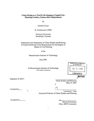
  • 1. Urban Design as a Tool for Re-Imaging a Capital City: Planning Conakry, Guinea after Independence by Jennifer Czysz B. Architecture (1996) Norwich University Northfield, Vermont Submitted to the Department of Urban Studies and Planning In Partial fulfillment of the Requirements for the Degree of Master in City Planning at the Massachusetts Institute of Technology June 2001 @Massachusetts Institute of Technology All riohtq reserved Signature of Authn- MASSACHUSETTS INSTITUTE OF TECHNOLOGY JUL 3 1 2001 LIBRARIES .4tOTQH Urban Studies and Planning May 25, 2001 Certified by_ Associate Professor of Urban Lawrence J. Vale Studies and Planning Accepted by Dennis Frenchman Chair, MCP Committee
  • 2. URBAN DESIGN AS A TOOL FOR RE-IMAGING A CAPITAL CITY: PLANNING CONAKRY, GUINEA AFTER INDEPENDENCE by Jennifer Czysz Submitted to the Department of Urban Studies and Planning on May 25, 2001 in partial fulfillment for the degree ofMaster in City Planning ABSTRACT Guinea, unlike any other French colony in West Africa, had refused assistance from the French in transitioning to an independent nation. As a result much of what the French had created began to decay lying unused by the new nation and abandoned by the French, leaving behind what were described as ghosts. These ghosts were abandoned buildings and railways throughout the country. There were other ghosts besides the abandoned infrastructure of the French. They had in fact influenced the shape of cities and architecture. In this research I intend to answer the following question: How does a newly independent former colonial capital city use urban design plans to create a new image representing the new nation? To answer this question I will explore the attempts of Conakry, Guinea to use an urban design plan (1963) to redistribute land and resources to create a new post- independence image. This question thus entails an analysis of intentions. What actions did the plan propose to create a unique image of a capital city in an independent nation opposed to a colonial territory? How were the political, social and economic ideals of the new nations represented in the design? To understand the design plan I first examine Guinea and Conakry's historical past to gain an understanding of the existing conditions at independence. I then explore the theory of creating a national image, African responses to independence and several case studies in order to understand common trends and the process of re-imaging a post-independence capital city. Analysis of the 1963 urban design plan for Conakry reveals four large gestures that were to create a post-independence image for the city. First, the plan decentralized the urban and political city centers. Second, circulation focused on developing connections within the City opposed to creating a flow toward the port and out of the City. Third, public services were to be distributed equally throughout the City for all citizens. Lastly, the City was to become homogeneous, where all people were equal, and segregation ceased to exist. Thesis Advisor: Lawrence J. Vale Title: Associate Professor of Urban Studies and Planning
  • 3. ACKNOWLEDGEMENTS I have many people to thank and recognize for their assistance throughout my studies at MIT and during the thesis process. I would like to thank my thesis advisor, Larry Vale, thesis reader, Anna Hardman, and academic advisor, Marc Schuster, for your guidance and encouragement. Thank you to all the amazing babysitters, without you I don't know when I would have done all my work. Particularly I would like to thank Milena and Jodie, who were there on a daily basis. Rossana, Ana, Madhu and Erica- thank you for being there when I was in a pinch. You ensured that I could complete my work and Elijah would get all the attention he needed. To my family- Mom, Lisa, Craig and Selma thank you for the encouragement, study breaks, and help with Elijah. Elijah, thank you for being such a sweet baby. You both bring so much joy to me. Lastly, to my husband Aaron, you have been the greatest support to me throughout the thesis process and my studies at MIT. Without you my success would not have been possible. Thank you for your devotion and endless encouragement.
  • 4. TABLE OF CONTENTS Abstract 2 Acknowledgements 3 Table of Contents 4 CHAPTER I:INTRODUCTION 5 Introduction: Conakry and the Creation of an Image 6 CHAPTER 11: CHALLENGES 9 The French in Conakry- Colonial Rule and Independence 10 What are the challenges of a post-colonial capital city? 26 CHAPTER III: HOW DOES A NATION RE-IMAGE AFTER INDEPENDENCE? 43 Decolonization and the Creation of National Identity and Image 44 African Responses 52 Forms of Development and Response to a Regime Change 54 Examples of Post-Independence Urban Design Responses 56 Generalizations 65 CHAPTER IV: AN ATTEMPT TO CREATE A NEW IDENTITY 67 Building a New Nation 68 Goals and Objectives 79 A New Organization and Image for the City 90 CHAPTER V: THE REALITIES OF CONAKRY'S NEW IMAGE 116 Implementation 117 Conclusions 125 APPENDICES 128 A. Time line of Guinea's History 129 B. General Maps 130 BIBLIOGRAPHY 131
  • 5. I: INTRODUCTION: CONAKRY AND THE CREATION OF AN IMAGE
  • 6. I: INTRODUCTION: CONAKRY AND THE CREATION OF AN IMAGE In the middle of the twentieth century the collapse of colonial empires led to a surge in the formation of new nations. Many of these nations felt compelled to establish their own identity and, as part of this, a new image for the capital city. This thesis attempts to understand how regimes, in newly independent former colonial nations, have tried to use urban design plans to create a new image of the capital city, as a representation of the post colonial regime in the new nation. The 1963 Conakry, Guinea urban design plan is explored as one case of a nations attempt to redistribute land and resources to create a new post- independence identity. Guinea, led by Sekou Toure, was imbued with systems and institutions created by its former French colonial rulers, particularly within Conakry itself. The French had developed a method of zoning that segregated the city by ethnic and economic means and only those in the most privileged zone were afforded services and infrastructure. For the French, Conakry had been a site of resource exploitation and extraction, and was dependent on the port and exports. At the end of the colonial era, Guinea was the only former French Colony in West Africa to reject assistance from France as it embarked on independence. As a result the French destroyed many of the resources they had developed and Guinea was left without the technical or financial assistance that many other nations received in establishing self-rule. Consequently, Guinea turned to the eastern bloc nations for assistance. Each newly independent society faced many challenges in the move to create identity and autonomy. Nations have to decide what to do with the physical structures left from the previous regime and how to establish a new political regime. For the nations of West Africa, national boundaries were not representational of ethnic boundaries, leaving the new nation without a unified population. The new nations had to cope with the need to build new institutions, accommodate rapid urbanization and general disparities within resource distribution. Lastly, one of the greatest hurdles to complete independence were persistent and often pernicious negative foreign influences manifested in neocolonialist and dependent international relationships.
  • 7. In response to the many challenges African nations had to face they took one of three responses to independence and the establishment of a unique and autonomous identity. Some nations became even more nationalistic and often developed hostile opinions of western nations. Other African nations developed a foreign policy of nonalignment and positive neutralism, allowing the nations to preserve economic independence and accept assistance from any nation. Lastly, some new countries experimented with different variants of socialism unique to Africa. During colonialism the indigenous physical environment was transformed by the introduction of western architecture and planning. To create a national image at independence the emergent nation set out to establish a form representational ofthe new nation. The creation of a new urban form was directly related to nationalism. In many countries, the creation of a new and conspicuous capitol complex signified the autonomy and power of the new regime. There were many different ways in which a nation could make a statement of its new image using urban design. Of the three possible ways in which a nation could respond to a regime change the first two would establish a new image for the nation and the third would inhabit the existing form and image. The first way of establishing a new image was to create a new capital city in a new location. The other approach was to redesign the existing capital city. The third possibility was the nation could choose to assume the identity and image of the former regime and occupy the unchanged capital city. Sekou Toure and the leaders of Guinean independence chose to retain the capital city in Conakry. Toure achieved power in an extremely divided ethnic state with a platform of equality for all ethnic groups. To move the capital from Conakry would be to leave behind the only "ethnically neutral" city. In choosing to remain in the same city, the Toure administration chose to have the city redesigned to represent the new regime and distance itself from the French regime. Unlike many other nations who utilized urban design plans to re-image the capital city, there is no literature that describes Toure's intentions or desires for the 1963 plan. There is a
  • 8. chance that the literature may exist, but not in sources available in the United States, but in Guinean national archives. For most post-independence heads of state undertaking capital redesign, the design was an obsession or top priority, frequently appearing in speeches or period literature. This appears not to be the case in Guinea. Thus, we do not know whether the plan was a national priority or not. In 1961 a team of designers from Yugoslavia was invited to develop a new plan for the city. Conakry PlanDirecteurd'Urbanismewas the culmination of collaborative work between the two nations and was completed in 1963. This was one of the first urban design plans to attempt to re-image a post-independence capital city in Africa. Most of the plan was never implemented, due to an immature financial state and underestimation of urban growth. Nevertheless the plan itself gives us insight into the intentions of re-imaging in the early stages of independence. Conakry's new image was to be created through the decentralization of the city's major urban and political systems. The city was to be oriented away from the port and former French seat of power and focus inward to the mainland. Resources and services were to be distributed throughout the city more equitable than under French control. Lastly, the city was to become a homogeneous entity, free of ethnic divisions. The next chapter explores the history of Conakry's growth and the challenges it faced at independence as a result of its past. The third chapter examines the theory of identity and image creation, and case studies of other capital cities. This serves to explain how a post- independence nation could respond to its past and establish a new image. The fourth chapter analyses Conakry's attempt at the creation of a new image utilizing the 1963 Yugoslavian urban design plan. The final chapter discusses the implementation of the plan, both the planned and actual results. Lastly, I conclude with remarks delineating how a post- independence nation, through its intended plans, may re-image the capital city.
  • 10. II: CHALLENGES THE FRENCH IN CONAKRY- COLONIAL RULE AND INDEPENDENCE The existing state of Conakry in 1963 was a direct result of its historical past. The physical, political and economic conditions, established by the French colonial regime, created challenges for Guinea to overcome in the development of a national identity and image. The challenges that the city faced at independence would drive the goals and objectives of the urban design plan Development ofa Capital City Prior to 1880 French involvement in Guinea was limited to occupying Boke on the Nunez River, and Boffa, Dubreka, and Binty on the Mellacourie River (Fig. 1). Off the coast of what is present day Conakry, the British occupied the Isles de Los as part of the Sierra Leone Company since 1818. These were the Islands of Tamarra, Kassa, and Roum. Sierra Leone was interested in pushing its territory as far north as possible along the Atlantic coast. The French posts were blocking their way. Around 1880 in attempt to secure a post on the mainland and out maneuver the French, the British began negotiations with the chief ofthe small Konakry tribe on the Tombo Penninsula (an island during high tides), the closest mainland point to the Isles de Los. The French out maneuvered the English and went to the superior chief of the Kaloum Bagas in Dubreka and signed a treaty gaining control of the Tombo Peninsula, which is part of current day Conakry. The French had a double motivation for taking this land. The first motive was to recover the dignity that they had recently lost in being defeated at Matacong Island and to prevent the English from encircling their 4 existing posts in this part of the coast.' The acquisition process in 1880 did begin as that of negotiating for the purchase of land by the French. A treaty signed by the king in Dubreka (Bale Demba), the chief of Conakry Stern, J. The French Colonies: Past and Future. (New York: Didier, 1944) 164. Hargreaves, J.D. Prelude to the Partition of West Africa. (New York: MacMillan & Co Ltd, 1963) 130, 230-1, 247.
  • 11. Bisagos Is. Reference to numbered Rivers Boff I Dembia 1 Dubreka 3 Beriera 4 Fouricaria 5 Mellacoure 6 GreatScarcies 7 Small Scarcie; 8 Ribbi 9 Bumpe 10 Kagboro 1 Bagru 12 Bum-Kittam 13 Kittam SherbroL. SIERRA LEONE AND THE RIVERS Salek of Miles 0 A.5A 0 7Sae5 100 SAMU African States and Chiefdoms Kasseh Lake Cape Mount4 'S 1W14* |120 Figure 1: Southern Guinea Coast with French Territories and British Sierra Leone Source: Hargreaves, J.D. Prelude to Partition ofWest Africa. 130. -- tactmese rochers 0 village sentiel J tiaves ia 1ot * poste misltale Figure 2: Villages and Buildings ofTombo Island, c. 1889 Source: Goerg, Odile. "Conakry: Un Modele de Ville Colonial Francais?" 314.
  • 12. (Benti Sori), and the chief of Boulbinet (Takou) allowed the French to declare the area a French protectorate for an annuity of 400 gourds, equivalent of 2,000 francs. An additional clause was added in 1885 to acquire land for the construction of a French post. From the beginning the creation of a French protectorate and post was contested by the Fulbe of the Fouta Djalon. When the French constructed a telegraph office in 1886 without the consent of the Guinean treaty signers, protests erupted and a higher annuity was demanded. Following the death of Bale Demba at the end of 1886, the French saw the opportunity to demonstrate their power and commenced a campaign of bombarding the villages. By May of 1887 the French had completely annexed Tombo. A treaty was signed in 1889, committing France to 2 continue the annuity payments until 1897. The French had their stronghold at Boke and Dubreka prior to the acquisition of Tombo. From Boke they sent expeditions into the Fouta Djalon. Dubreka, just to the north of the Isles de Los and Tombo was the administrative center of the Guinea coast. In the early 1880's there were three French buildings in the Tombo Peninsula, all of which were trade buildings (Fig. 2). After the establishment of a French protectorate this establishment remained a commercial site, dependant on the export ofrubber, for nearly 10 years before French administration or the militia moved here. In order to strengthen their position against the English, still occupying the Isles de Los, the French also negotiated to control Kaloum, the adjacent part of the peninsula moving inland, in 1887.3 Since the 1830's the French had been looking for a new commercial center to locate south of Dakar and Goree Island. After Conakry had been established as a French protectorate and control of the land secured, the French Commandant in Dubreka decided that Conakry should be the new commercial site and port the French were looking for because of its deep water and projection. Also, the location was relatively uninhabited and devoid of any strong 2Goerg, Odile. "Conakry: Un Modele de Ville Coloniale Francaise?" Cahiers d'Etudes Africaines. Vol. 25, no. 99, 1985. 310-313. 3Riviere, C. Guinea: the Mobilization of a People. (Ithaca: Cornell University Press, 1977) 39-49. Urbanisticki, Conakry: Plan Directeur d'Urbanisme. (Zagreb: 1963) 11-12.
  • 13. political powers. The French developed the city to be a profitable port of export for the colony's many resources.4 In 1885 the head of Dubreka moved to Conakry and a post and telegraph office was opened. In 1890 Conakry was declared the chief French location among the southern rivers of the Guinea coast. In 1893 Guinea was officially established as a colony and Conakry as the capital. It wasn't until about 1900 that they were able to begin construction of a governmental nature.5 Following the bombardments of the Baga Villages the population on Tombo, once 300, fell to under 100 people. With such a small population and part of the existing villages destroyed, Conakry appeared to be an open location for the French to create a new city. After Guinea was declared an official colony with Conakry as its capital, the colonial administrators conceived of the site as the ideal French Colonial capital city. The new ideas of sanitation and hygiene and the separation of differing lifestyles could be implemented freely with a fresh terrain to design.6 In 1900 the French drew up a plan for the Tombo Peninsula (Fig. 3, 4). This plan was a response to a three-phase construction plan, tied to economic growth for 1890-1910. The plan initially displaced just the Conakry and Boulbinet villages and eventually called for building where the villages of Tombo and Kroutown were. The village of Conakry, unlike the others was relocated to a point further east as this space was not to be a residential area.7 4Goerg, Odile. "Conakry: Un Modele de Ville Coloniale Francaise?" 309. 5Goerg, Odile. "La Guinee Conakry." In Rives Colonial, edited by J. Soulillou. (Marseille, France: Editions Parentheses, 1993) 84-5. 6 Goerg, Odile. "Conakry: Un Modele de Ville Coloniale Francaise?" 310. 7 Goerg, Odile. "From Hill Station to Downtown Conakry: Comparing French and British Approaces to Segregation in Colonial Cities at the Beginning of the 20th Century." Canadian Journal of African Studies. Vol. 32, No. 1, 1998. 12.
  • 14. Figure 3: 1900 French Plan for Conakry, drawn by Famechon Source: Goerg, Odile. Pouvoir Colonial, Municipalities et Espace Urbain Conakry-Freetown des Annees 1880 a 1914. vol. 1. Carte 11. Figure 4: Subdivision ofLots c. 1912 Source: Goerg, Odile. "Conakry: Un Modele de Ville Colonial FrancaisT 314. - 6 [,4 AOui 193
  • 15. The seat of French power was placed at the western most tip of the peninsula. As this piece of land was secured early in the acquisition process, it was between the villages of Conakry, Kroutown and Boulbinet, without displacing any of the existing Africans. The Famechon 1900 map of the city identifies the occupants of the lots and lets us discern who lived approximately where in the City. The French population clustered around the government and administrative buildings at the western tip. At the southwestern end of the island, at about where Boulbinet existed were several of the Sousous chiefs and notables. The next layer of inhabitants moving eastward was English, Portuguese and other non- Western whites. Senegalese probably of the Wolof tribe occupied the south-center of the island. The area furthest east was left for indigenous Guineans, typically the Fulbe who had strong ties with the French through trading.8 The French plan for the city was formal and set up on a grid reminiscent of Paris of Washington, DC (Fig. 5). As the city expanded the grid grew in response. By 1904 the city had grown to include some buildings on the Kaloum peninsula. The city had filled the Tombo Island and was becoming dense on Kaloum by 1940.9 The plan for Conakry was centered on commerce development and the facilitation of exporting goods (Fig. 6). At the center was the Avenue de Commerce, or 3'd Boulevard. This was the commercial heart of the city were shops, warehouses and other institutions were located. This route connected directly to the port and original market at the north. The second market place, three hangars, was built in 1900 in the center of the island after the plan was done because the original at the port was too small to accommodate the city. In 1954 the third market was built on the site of the second.' 0 At the north of the peninsula was the port. The railroad that stretched across Guinea culminated here. Also nearby were the customs house, general store, market, and courthouse. Moving inland from the port area, between the French and other nationalities 8 Goerg, Odile. "La Guinee Conakry." 84. 9 Urbanisticki, Conakry: Plan Directeur d'Urbanisme. (Zagreb: 1963) 11-13. ' Ibid., 87-8, 95.
  • 16. (. - / / 190*.AM9 Figure 5: Growth in Conakry From 1895 to 1941 Source: Urbanisticki. Conakry: Plan Directeur d'Urbanisme. 12 Figure 6: Key Points ofInterest in Conakry Source: Goerg, Odile. Pouvoir Colonial, Municipalities et Espace Urbain, Conakry-Freetown des Annees 1880 a 1914. vol. 2. Carte 10. A: ce.mmchI Get: Bfl~ dogynnea Ud: bsued Ay* memo 9 Mm Figure 7: The Three Zones Source: Goerg, Odile. Pouvoir Colonial, Municipalities et Espace Urbain, Conakry-Freetown des Annees 1880 a 1914. vol. 2. Carte 14. &"tL m-- ""?um~h
  • 17. homes was the school. The engineering office was located on the coast halfway from the port to the Hotel du Gouvernement, which was at the center of the western coastline. The Hotel du Gouvernement is situated such that those sailing up and down the coastline would see it and it faces the English Isles de Los. Just to the north of the Hotel du Gouvernement is the ambulance and the post and telegraph office. Just to the south are the printer's office, treasury, and administrative offices. Along the southern coast there are a public garden, separate cemeteries for the French and Africans, and the slaughterhouse (directly adjacent to the African cemetery). Further to the east on the southern coast is the Hospital Ignace Dean, removed from the French residential area due the perception of the French that a hospital is the storage house of disease and a threat to their health and safety. Near the Kaloum end of the peninsula was a caravanserai, or an inn for travelers, located adjacent to a Fulbe village. At the entrance to the peninsula from Kaloum it was necessary to build a bridge as this strip of land flooded during the high tides making Tombo an island. 1 Originally, until 1901, the city was divided into two zones: that around the Hotel du Gouvernement and that of the rest of the city. In the first zone residents were required to spend more on the construction of their homes. In 1905 this was expanded to be 3 different zones (Fig. 7), delineated by minimum cost of construction per square meter and dictation of acceptable building materials. The first zone was built on the western and northwestern coasts of the peninsula and through the center, cutting the second zone into two parts. The second zone was at the middle of the island divided into north and south sections by an extension of the first zone. Lastly, the third zone was at the eastern end of the peninsula leading inland.13 It was thought that the division of the city would potentially solve "problems of urban health, elevated mortality rates, and sanitation.' 4 " Additionally, zoning was driven by the fear of fires, resulting in the regulation of acceptable building materials. The division of zones was not overtly on racial segregation but on economic segregation. The first zone allowed only buildings that cost a minimum of 7.5 francs per square meter, to "1Ibid., 84. 12Goerg, Odile. "From Hill Station to Downtown Conakry." 12-13. 13 Goerg, Odile. Pouvoir Colonial, Municipalites et Espaces Urbains. (Paris: Harmattan, 1997) maps 14 and 15. 14Goerg, Odile. "From Hill Station to Downtown Conakry." 3.
  • 18. construct, and the population was entirely French. The second zone maintained a minimum of 4 francs per square meter. The population of the northern half of the second zone was non- French European and the southern half was indigenous. The third zone, also called the indigenous zone had a minimum of 1.5 francs per square meter.'5 Given the lack of an African middle class, the economic zoning virtually assured ethnic segregation with the exception of a few African nobles able to afford the costs of the first zone, otherwise called the central zone. Despite the division by economic means, the third zone was officially called the native zone. Furthering the distinction between the zones, uses that were deemed dangerous, such as the hospital, prison, and military camp were built in the third zone. Given limited resources for the implementation of infrastructure such as sewage, paved roads, waste removal, and piped water were only supplied in the first zone. 16 To further promote the segregation of ethnic and economic groups the French declared, for all zones, that it was illegal to build using indigenous construction materials and techniques. Traditional materials such as adobe and thatch were thought to be unsafe by the French. Instead, relatively expensive materials such as corrugated metal for roofs, cement, bricks, paint, and certain types of wood were imported from Marseilles, France. All homeowners in all zones were required to build a permanent structure in a European fashion on their lot within two years. The construction standards were not always adhered to. In both the first and second zones Rectangular homes of one and two stories were typical. The buildings of the first zone were built using masonry, were two stories and more elaborate than the second zone's more simplified single story wooden villas, or casas. The third, eastern most, and indigenous zone was composed of huts.17 The three zones of construction most affected the housing stock since the majority of all administration, government and public buildings were located in the first zone. The French 15 Goerg, Odile. "La Guinee Conakry." 86. 16Goerg, Odile. "From Hill Station to Downtown Conakry." 12-13. 17 Ibid., 85-6.
  • 19. owned all of the homes, particularly those of Africans' . In the 1950's in order for the French government to create homes for the administrative officials in the first zone high-rise apartment buildings were built. One example is the Boulbinet Towers; two identical 10 story towers built on the former Boulbinet village.' 9 The 1940's were marked by the expansion of Conakry. No longer was Conakry considered just to be Tombo but it was now the combined land of Tombo and Kaloum now. With this expansion, the former inhabitants of the second and third zones were pushed further inland and the French occupied these zones. As a result it was necessary to update these areas with more modern forms of construction. The corrugated metal roofs were replaced with slab roofs, and fans and air conditioners replaced the wraparound verandahs. 0 The French described African occupied quarters such as Boulbinet and Coronthie, originally settled by Baga and Sousous nobles in the first zone, as "bidon villes" or slums at the end of the 1940's. Indigenous quarters had been built without regard for building regulations, modern construction techniques or "civilized" and "sanitary" modes of life. Roland Pre, governor of Guinea in the 1950's, cites two reasons why the African population of Conakry lived in "substandard" housing. First, Africans were not entitled to own land thus making it difficult for an African to be able to build a permanent structure for themselves to live in. Secondly, African quarters weren't well planned. As a result, collective urban resources were not allocated space in these quarters. Pre believed that until the social and communal 21 facilities had been allocated land, private land could not be subdivided or sold. Pre cites three solutions to the indigenous housing problem in Conakry. First, it must be possible for Africans to have the means to participate according to Guinean regulations; this indicates the development of some form of financing assistance, possibly in the form of loans. Second, this organization providing financial assistance needs to be decentralized 18Pre, Roland, L'Avenir de la Guinee Francaise. (Paris: Lescaret, 1951) 234. 19Goerg, Odile. "La Guinee Conakry," 96-102. 20 Ibid., 101-2. Pre, Roland, L'Avenir de la Guinee Francaise, 245-6. 21Pre, Roland, L'Avenir de la Guinee Francaise, 233-234.
  • 20. enough so that it can reach all urban areas in need. Lastly, he advocates the strict enforcement of building regulations requiring modern construction.22 France's aim after World War II was, with its holdings in West Africa, to become an economic power equal to that of the USA or USSR, at least in the mind of Roland Pre, Governor of French Guinea. He believed the natural and agricultural resources located in Guinea, and the rest of French Africa, were the key to wealth for France and Africa (Fig. 8). These resources were what Africa was to the French, as demonstrated by the French map of Guinea included in his book. The map shows all of the cities and villages that were sources of bauxite, gold, diamonds, other metals, and agricultural products. All of the roads in Guinea connected these sources to Conakry. Additionally, the railroad and airports served to strengthen this transportation network. When Pre answers the question "What is Guinea?" in his text, he describes it as a prosperous country due to its great exports, particularly of fruits. Additionally, it is a nation where considerable growth and increased wealth can be realized. Pre described the population of Conakry as mixed. In 1949 the population of Tombo Island was believed to be 36,000, of which 1950 were French and 791 other Europeans. Including the suburbs Conakry's population was estimated at 45,000. Conakry grew rapidly partially caused by the mining efforts of bauxite and iron in the city outskirts. The population of Conakry doubled from 1939 to 1949. At the start of the 1950's Conakry was growing onto the Kaloum peninsula. There were three axes into the peninsula, which divided the new districts of the City. There was the north and south routes and the railroad down the center. The railroad ran through the center of mines as a direct connection between the mines and the port. Along the northern and 2 Ibid. 235-236. 23 Ibid. 13-16. 24 Ibid., 23-27. 25 Ibid., 30.
  • 21. Figure 8: French Map of Guinea in the Late 1940's Source: Pre, Roland. L'Avenir de la Guinee Francaise. 20. .A PESOU LE DU K A LOUM Figure 9: French Plan for Growth in Conakry in the Late 1940's Source: Pre, Roland. L'Avenir de la Guinee Francaise. 20.
  • 22. southern coasts were new housing and administrative buildings. In 1949, at the time Roland Pre's book was printed there were three subdivisions in progress in. Donka was planned for individual families to build at their own expense. Dixinn was planned for the Fulbe people to upgrade their homes from huts to modem structures with financial assistance of the administration. The third was public housing planned along the southern coast of Kaloum to provide a first modem home for Africans. In order to provide infrastructure and resources to Kaloum, Pre suggests incorporating the suburbs of Kaloum into Conakry as one large city.26 As Conakry grew, new facilities were needed to support the population (Fig. 9). At mid 2 0 th century some projects planned for the city were the expansion of the medical center, an educational center, a school health program, a city hall, and a new stadium (in Kaloum). Additionally, there was the need for more electricity, improved water supply and roads.27 Pre proposed expansion of the port on the northern coast in response to expected increased agricultural and mineral production and exportation. There would be both a commercial and mining ports. The port was scheduled to be ameliorated by 1951. A metropolitan rail line was to be added, connecting the port to a new iron mine running through the center of the Kaloum peninsula. There was an industrial center proposed in the suburb of Manea. The neck connecting Tombo and Kaloum was filled, widening it and making room for multiple roads to cross. Additionally, the French made plans for the Isles de Los, which they now 28 controlled. Conakry (and Guinea) had now outgrown its purpose of outmaneuvering the British and by the 1950's it had become a major source of income and resources for the French. The Political Structure The colonial era in Guinea can be broken into two separate ages. The first was from 1890- 1945. At that point an era of decolonization began, culminating with independence in 1958. 26 Ibid. 245-248. 27 Ibid. 249-255. 28 Ibid. 257-260.
  • 23. When the French took control of Guinea, all existing forms of governance were destroyed and replaced by a French system that did not afford rights to the African populace. The French National Assembly governed the colonies and allocated significant power to those administrating the colonies. French law was adapted to suit the colonies. A colonial Governor, who was appointed by the French Colonial Minister, led the nation. Power was then distributed to French administrators and African canton chiefs, appointed by the French Governor. The French established a monetary tax system that directly affected the traditional African lifestyle, which relied on a bartering system. The French would not accept the African society's currency for tax payments. This forced the Africans to move to urban centers where they could find salaried work. This rural to urban migration disrupted the traditional subsistence household economy. To further aggravate the situation, canton chiefs would abuse their power and collect more taxes than were actually due. This tax system led to a general suspicion and dislike of the colonial government, an attitude which continues to be manifest today toward the current national government.29 France did not budget enough money for Guinea to develop its infrastructure because the colony was of minimal original importance to the French. As a result it was necessary to export goods to their highest capacity to generate capital. Exports were predominantly tropical fruits grown on French owned plantations. Additionally, European trading companies, based in France, ran mines and the exploitation of natural resources. Because Guineans farmed on a subsistence level they did not participate in the economic flow of exporting. The French economic structure forced Guineans to migrate to urban areas or French plantations in order to earn enough to pay their taxes to the French government, thus beginning the system of urban migration.30 The process of decolonization began in 1945, when over the course of the next thirteen years three major changes were instituted. First, Guineans were granted citizenship, all adults having suffrage by 1957, and since they were no longer French subjects they were entitled to representation in the government. Second, multiple competitive political parties were 29 Waldstein, Alfred. Guinea Social and Institutional Profile. (Conakry: USAID, 1991) 59-60. 30 Waldstein, Alfred. Guinea Social and Institutional Profile. 61-62.
  • 24. developed. Lastly, the Parti Democratique de Guinee (PDG) became the predominant political force. 31 From 1946 to 1956 Guinea sent Africans from the different political parties to the National Assembly in Paris. The conservative Fulbe led parties, backed by the French administration, dominated Guinean national representation in Paris and aligned themselves with the French Socialist Party. Sekou Toure led the radical and nationalist PDG as the main competition against the Fulbe parties. The party focused on creating interethnic support and by 1956 held 62% of the votes and sent Sekou Toure to the French National Assembly and in 1957 the party won 59 of the 60 seats in the Territorial Assembly. In 1957 Sekou Toure formed a Guinean national government, which shared the executive power with the French administration.32 Elimination of Resources On September 28, 1958 under the leadership of Sekou Toure, the Guinean population voted against the De Gaulle Constitution and continued status within the French Empire due to the lack of equitable relations proposed between France and African nations and organizations. As a result of the no vote, Guinea became the first independent former French colony with Sekou Toure as its President. Over the next two months the French completely withdrew from Guinea and severed all relations. All French government employees were re-assigned to other posts in West Africa. In response, Sekou Toure reassigned the French housing to upper level officials in the new Guinean government. Guinea received little financial assistance from Western nations at the onset of independence and thus turned to the Eastern Bloc nations.33 France, in attempts to punish Guinea for its no vote, withdrew all technical and financial assistance. They pulled out personnel such as teachers, doctors and technicians. Additionally, they destroyed documents and took all office supplies and equipment with them. Guinea was left without trained personnel to fill the vacant positions and run the 31Ibid. 64. 32 Ibid. 64-65.
  • 25. administration. While Guinea had made progress toward being self-sufficient during the 13- year decolonization period preceding independence, they were not prepared or capable of fulfilling all the roles and functions of an independent government.34 3 Nelson et al. Area Handbook for Guinea, (Washington, DC: Foreign Area Studies, American Univ., 1975) 37-40, 99. 3 Waldstein, Alfred. Guinea Social and Institutional Profile. 68.
  • 26. WHAT ARE THE CHALLENGES OF A POST-COLONIAL CAPITAL CITY? During the late 1950's and early 1960's more than 50 nations achieved independence from their colonizers leading to an emergence of new underdeveloped nations without the vast resources of the developed world. These new nations had many challenges to face given their independent status. Without the wealth and guidance of the former colonial power, many new nations didn't have the expertise to run their new nation and often lacked the resources needed. Essential to independent nations was the establishment of equality among its citizens; this is a theme that underlies virtually all challenges to an independent nation. Additionally, was the need to create a new national identity and unity within an often ethnically divided nation. In light of the physical structure and political system of the former regime the new nation had to decide how to govern itself, whether to keep and occupy the former system or to create a new system. Lastly, and the topic of this research is how would the nation represent itself in its physical realm to create a new independent image? Existing Physical Structures The colonial regimes were not concerned with equality in their city planning. For example, Gwendolyn Wright in The PoliticsofDesign in FrenchColonial Urbanismdescribed the work of Ernest Hebrand a young architect and Urbanist. Hebrand believed in a unified need of all people for air, light and leisure yet felt it necessary to maintain design policy entailing zones divided by socioeconomic class and occupation. He used a divider such a canal to separate the indigenous population, employed and housed in the industrial area across the division line from the higher-class housing.35 This system of zoning and segregation of not only socioeconomic class but ethnicity and rank in society prevailed through the colonies. In Conakry, the French had employed a system of zoning (discussed in the previous section on the French in Conakry) that was exclusionary and created a strong disparity between Tombo, home of the elites, and Kaloum, home of the Africans. This became the first challenge to the new independent nation. How could the new regime create a greater sense of equality in the City? 35 Wright, Gwendolyn. The Politics of Design in French Colonial Urbanism. (Chicago: The University of Chicago Press, 1991) 64-65.
  • 27. French planning of Conakry oriented all toward Tombo (Fig. 10). All roads and rail lines lead into Tombo and out the port. The port while well sited as a port, is in a key location of the city and blocks access to the ocean of Tombo's inhabitants. As a result Kaloum was divided in a manner that divided the north from the south without connection between the two. As the coastal edges provided preferred housing sites and the center contained minerals that could be mined, roads were created only running along the north and south coasts. Down the center of the peninsula were the railroad, industries and mines creating a visually undesirable and circulation division of the peninsula. Additionally, the airport was situated in the midst of the suburbs on the southern coast of Kaloum, blocking further expansion of the City. Lastly, Donka Hospital, the only hospital in Kaloum was located adjacent to the railroad and industrial areas, creating an undesirable atmosphere and less than hygienic location.36 Former Power Structure For most colonial nations the colonized population did not have the right or opportunity to participate in the governmental system. Colonial political systems were modeled after that of the colonizing nation, yet giving the colonial leaders sovereign powers over the Africans. For most emergent independent nations the lack of possible involvement in the colonial political system created a shortage of persons with the expertise to run an independent nation. As a result, the first decade of independence politics were marked by "personal rule and political domination and political life has pivoted around individual leaders... "7 While this independent rule by the elite seems reminiscent of politics under the colonial regime it is almost to be expected given the few qualified individuals and negative example set by the colonial regime. For nations that maintained close ties with their former colonizers, escaping the past political regime and structure was more difficult than for nations such as Guinea and Ghana who had severed ties with their former colonial oppressors. 36 Urbanisticki. Conakry: Plan Directeur d'Urbanisme. 22-24. 37 Rakodi, Carol. "Global Forces, Urban Change, and Urban Management in Africa." In Rakodi, The Urban Challenge in Africa. (Tokyo: United Nations University Press, 1997) 27.
  • 28. Figure 10: Land Use in Conakry Prior to 1963. Source: Urbanisticki. Conakry: Plan Directeur d'Urbanisme. Following p. 32. 00
  • 29. 'Lapido Adamolekum in Sekou Toure's Guinea identified three main hurdles for achieving a new political system in Guinea. First it was necessary to establish a central authority. This entails the structuring of a political organization that could distribute authority from the center to the smallest quarter or village. Second, it was necessary to bridge the gap between the elite and the masses, creating a political equality amongst all people unlike the French system. Lastly, was to develop a system where the masses could be involved in the political system.38 National Boundaries Without Regard for Ethnic Boundaries The process of colonization was not about the indigenous populations. It was about power and capital gain. As a result little attention was paid to where national boundaries were drawn and they became a function of the colonizers power and conquest amongst the efforts of the other colonial powers. This created one of the largest challenges to the independent nations aside from a lack of resources, a lack of a common identity and unity.39 Each nation was faced with the necessity of creating some form of union between all ethnic groups, when they were historically opposed, or make the choice to disband as a nation into smaller splinter nations. While no nation at the onset of independence chose the latter, many nations have been plagued by political overthrows and civil wars between the ethnic groups. Sekou Toure in describing Guinea, states that it is 'constituted as a juridical state rather than a historical entity.' 40 Prior to independence, when the creation of positive ethnic relations became a goal of the nation, Guinea had been known in French West Africa for its intense ethnic rivalries.41 Guinea is divided into four natural regions: Lower Guinea (the coastal area), Middle Guinea (the Fouta Djalon), Upper Guinea (grassy savannahs), and the Forest Region (south eastern most part). These four natural regions also reflect the ethnic composition of Guinea (Fig. 11). The Susu and the Baga people today predominantly inhabit Lower Guinea. The Fouta 38 Adamolekum, 'Lapido. Sekou Toure's Guinea. (London: Methuen & Co., 1976) 16-40. 39 Adamolekum, 'Lapido. Sekou Toure's Guinea. 116. 40 Toure, Sekou. Concevoir, Analyser, Realiser. Vol XII (Conakry: 1966) 44. 41 Adamolekum, 'Lapido. Sekou Toure's Guinea. 125.
  • 30. Figure 11: Ethnic Groups ofGuinea Source: Lamp, Frederick. La Guinee et Ses Heritiges Culturelles. 2. -29
  • 31. Djalon is the home to the Fulbe population. Upper Guinea is the Malinke people who are descendants of the former Mali Empire (possibly once centered around Kankan in Upper Guinea). The Forest is the center of Christianity and Animism within the predominantly Muslim nation. The Kissi, Kpelle (Guereze), and Loma (Toma) are the three major ethnic groups of the Forest. All oftheses ethnic groups spill over into the bordering post-colonial states. The ethnic boundaries and the established colonial boundaries are in no way related to one another.42 Around 1960 in Conakry many of the ethnic groups lived in separate quarters of the City and typically had different occupations by ethnicity. Of the approximately 50,000 inhabitants of Tombo, Conakry at independence, 20,000 were Sousous, 8,500 Baga, 8,500 Fulbe and 5,000 Malinke. The Fulbe predominantly occupied Dixinn along the northern coast of Kaloum. The Baga were predominantly fishermen and carpenters and lived in Boulbinet and on the islands. The members of the forest groups, while few in number, typically were members of the military and lived where there were large grouping of military personnel.43 New Institutions to Accommodate A new government implies new structures to house the government. As a result it is necessary for the new independent nation to design and build facilities to house its new administration. A new nation is faced with the choice of re-using existing ex-colonial facilities or creating new. They could build on the former site of destroyed colonial facilities or found a new site altogether. The selection of location is dependent on what the new nation chooses to represent about itself. In the case of Conakry, it was decided that due the unequal nature of the French government in Guinea, it was essential to distribute or decentralize the location of government facilities, particularly to remove them from the French core on Tombo. 42 Lamp, F. La Guinee et Ses Heritige Culturels. (Conakry: Service d'Information et de Relations Culturelles, USIS, 1991) 2. 43 Urbanisticki. Conakry: Plan Directeur d'Urbanisme. 14.
  • 32. Educational facilities step to the forefront of new institutions that were needed. Access to education was not something that all subjects of colonial regimes had access to. The level of access varied from colony to colony. Population Growth and "Rapid Urbanization" At the onset of the 1960's only approximately 18% of Africa's populations lived in urban areas, while the average in West Africa was slightly lower at approximately 15%. Within West Africa, Senegal had the highest urban population at 32% and Ghana had 23%, whereas Nigeria, the most populous nation of West Africa, and Guinea each had 14% of the total population living in urban areas.44 In 1958 Conakry constituted 3.9% of the total population of Guinea. Due to the nature of Colonialism and the need of the indigenous populations to find salaried jobs with which to pay taxes there was a strong draw to the urban centers, which in the 1950's urban growth ranged from 4 to 6%. This contradicted the restrictive attempts of the colonial leaders to limit growth in the urban areas and the creation of a limited number of industrial and other low skill employment opportunities. While after independence this rate grew even higher with most of the growth coming from migration from rural areas. Conakry was one of the few West African capitals to see an urban growth rate of over 10% in the 1960's and early 1970's. 45 Much of the high growth rates can be attributed to the income disparities between rural and urban areas, thus causing a rural exodus. This placed an increase on the already strained formal sector employment opportunities, the rising unemployment rates of the urban areas, and shortages of housing. In most African nations a large percentage of industrial employment was in the capital city, in Guinea half of industrial work was located in Conakry whereas one-third was in Accra and Lagos, two-thirds in Abidjan and 87% in Dakar. Secure and more lucrative employment is typically the main cause cited for rural-urban migration while another secondary cause is cited as a better access to education.46 44 Rakodi, Carol. "Global Forces, Urban Change, and Urban Management in Africa." 32-4. And The World Bank Group. "New Release No. 99/2155/AFR: Guinea Receives Urban Development Credit" http://worldbank.org/html/extdr/extme/2155.htm 45 Rakodi, Carol. "Global Forces, Urban Change, and Urban Management in Africa." 32-4.
  • 33. In 1958 the population of greater Conakry was 78,400, whereas less than a century prior it consisted of no more than 300 people in a few small villages. Shortly prior to independence it experienced a large explosion in the population, having nearly doubled from 26,000 in 1946 to 50,000 in 1955. In the Plan Directeur d'Urbanisme for Conakry a population of 300,000 was estimated to occupy greater Conakry by 1990. The planners expected 25% of the Guinean population to be living in urban areas by that time and hoped to slow rural urban migration.47 To slow urban growth, one proposed option was to modernize agricultural practices, making rural farming more profitable and desirable. Another idea was to develop mining and industrial centers within the country. Lastly, was to develop a higher quality of transportation infrastructure, including international airports within the interior, thus reducing the international traffic through Conakry.48 In the two years following independence Conakry saw even higher growth rates than before independence. Within the Tombo island there was a 42% population increase, in Kaloum's closest suburbs 45% and in the further suburbs 79% growth. Overall, greater Conakry saw a 45% population growth. Within Tombo the greatest densities are found in Boulbinet, Sandervalia, Almamia and Koronti ranging from 400 to 600 persons per hectare in predominantly single story housing. Whereas, in Kaloum's suburbs housing was much more dispersed.49 Such growth rates led to a shortage of housing and legally buildable land in Conakry. Planning and land registry offices were unable to cope with the influx of requests. As a result there was a surge of unplanned informal housing'. Mining in Conakry, conducted by the French, occupied a large part of land down the center of Kaloum, this land; virtually uninhabitable was essential for the provision of housing.50 46 Ibid. 36-7. 47 Urbanisticki. Conakry: Plan Directeur d'Urbanisme. 8,13.48 Ibid. 7. 4 9 Ibid. 15.
  • 34. In 1960 only 59% of Conakry's population was employed. The majority (20.8%) of actively employed persons worked in the industrial sector. This was followed by 14.9% in administration and military, 11.2% in commerce, 8.9% in public service, 8.9% in transportation and communication, 8.9% in other positions, 7.4% in culture and education, 7.2% in construction and 5.9 in artisans services. The significant portion of employment other than industry in Conakry was located on Tombo, at the tip of the peninsula. For those who lived in Kaloum there was a 5 to 10 kilometers to travel, without public transit, to get to the employment center. Thus, in order to encourage the growth of the employment sector it was necessary to move away from the colonial core of the City out to where the majority of the population lived. The plan argued that given the increased urban growth and industrialization it was also necessary to consider the sources of food for the urban residents. A new emphasis need to be placed on agricultural and fishing practices, so that they can move beyond subsistence farming and the abandoned plantations can function profitable and provide for this growing population.5 1 Lack of Resources and the Changing Economy The economies of the newly independent nations, at the time of independence were dependent on the export of a few products, typically raw materials and agricultural products. Industry only accounted for 9% of exports in Sub-Saharan Africa.52 This rendered the nations dependent on the World Market for revenues. Additionally, the costs associated with running the mining facilities was too much for local entrepreneurs to run, necessitating foreign assistance, and furthering dependency. Additionally, affected was agriculture, where the knowledge base and necessary technology was not able to increase production in order to meet the demand. s0 Ibid. 15. 51 Ibid. 17.52 Rakodi, Carol. "Global Forces, Urban Change, and Urban Management in Africa." 29.
  • 35. In Guinea, French and Syro-Lebanese plantation owners dominated the agricultural sector that produced at a level for export. While Guinea was rich in mineral resources, which were actively mined and exported by the colonial regime, the export of coffee and bananas accounted for approximately 80% of the exports in 1957. The Guineans were but cheap labor in the agriculture system and were not involved in the management of the plantations. Much as they were lacking qualified personal to run the government and administration they were lacking qualified individuals to run the plantations and produce crops efficiently.53 To cope with the lack of resources, it became necessary to balance the location of all land uses so as to achieve the optimal results possible from the different sectors of the City. Housing, employment and transportation need to be balanced such that the employees commute time is reduced and there is adequate employment opportunities for all citizens. Key to the provision of a well-balanced system is the infrastructure that ties it together. Roads, water and services were required of new developments. 54 With the growth of an economic system and industry, comes the need for infrastructure. Without the vital infrastructure to provide a means of transporting, shipping and provision of electricity industry cannot function profitably. Conakry the plan argued, with its limited land supply was constrained in how much land could be allocated for industrial purposes. Yet, the many inhabitants of the City generated a demand for more jobs. Therefore it became necessary to attempt to find a balance of support for industrial growth balanced with residential growth. Another constraint on industrial development was tourism, seen to be another source of economic survival. Industry was perceived as a blight on the landscape and a deterrent to tourism. One solution was the implementation of a public transit system that would make employment and industrial centers more accessible.55 5 Adamolekum, 'Lapido. Sekou Toure's Guinea. 42. 5 Urbanisticki. Conakry: Plan Directeur d'Urbanisme. 24. 55 Ibid. 19.
  • 36. General Disparities The new nation was faced with the decision of how to represent itself in the social, political and economic realms. Yet those Africans that had been educated under colonialism and were capable of taking leadership positions were biased by their education. They had been schooled and trained in Western language and thought. How were they to represent their nation and culture with their western ideals? Sekou Toure in TowardFullRe-Africanisationcites this intellectual assimilation as a great challenge to the new nation. This led to a disparity between the "intellectual elite and the rural masses.56" He believed that the efforts of the French to indoctrinate the Guineans into a depersonalized and western way of life, believing their own roots to be primitive and savage, made the Guineans to be "more French than the French themselves. 57" Participation in the intellectual elite led to advantages that the masses did not have available. Under the colonial regime additional disparities separated the elite and the masses. Typically, the line was drawn between Europeans and Africans. All land in Guinea was owned by the French, who felt at the time of conquest the land belonged to no one, therefore it should belong to them. Thus, the Africans living in Conakry did not have the right to own the property they lived or worked on, whereas their French counterparts did. Within the military, a French man of the same rank and position as an African was allowed greater privileges. The French governmental administration served the needs and purposes of the French and dictated the lives of the Africans under its control. These issues of an ex-colonial nation's past create pressures on the new independent regime. Due to the colonial reign the masses are skeptical and do not trust the government and the elite. How must the new nation respond in order to bridge this and create trust, unity and equality in the society? Foreign Influences andNegative InternationalRelations Given the above-mentioned lack of resources, both financial and intellectual, the former colonies had little choice but to turn to foreign nations for assistance. While there were 56 Toure, Sekou. Toward Full Re-Africanisation. (Paris: Presence Africain, 1959) 9. 5 Toure, Sekou. Toward Full Re-Africanisation. 10.
  • 37. definite positive advantages to such collaboration, there were also definite risks involved as well. These risks have led to two different theories of development particular to post independent nations: dependency and neo-colonialism. When the relations between nations remained that of respect and fairness, there were no risks. But, given that many of the former imperialist nations did not wish to accept the end of the imperialist era perpetuated the risk. Additionally, other nations who had not participated in the era were looking to become involved, such as the US and USSR.58 While the new nations were trying to escape the influence and power of the former colonial regime, it was not only the former colonial powers that were threatening to the independent status of the emergent nations. The United States and the USSR were often cited as potential threats, practicing a new form of imperialism- neo-colonialism. The independent nations, while in need of foreign assistance to assist in national development, had to be wary of the intentions of those nations offering assistance. Were they looking to exploit the former colony depriving them of their resources and potential profits? For many nations that maintained relations with their former colonial rulers suffered continued dependence on the foreign power. Contrasting the potential dangers of the powerful nations interests in the developing nations, were the potential benefits of their interests. It appeared that a clever head of state could reap benefits from both the Soviet Bloc and the Western Powers by playing the two power groups against each other as each tried to buy the emerging nations interest. The nation's ability to remain neutral and not become subject to one system or the other was critical to this. There were two forms of development theory that focused directly on the negative relationships created between globally powerful nations and the post-independence nations. They were neo-colonialism and dependency theory. The writings and speeches of Sekou Toure often mentioned neo-colonialism and the imperative need to avoid it. 58 Tolno, Charles Pascal. Colonialisme et Sous-Development en Afrique. (Conakry: Editions Tolga, 1991) 10- 12.
  • 38. Neocolonialism Webster's dictionary defines Neocolonialism as "economic domination, and consequent political power over, underdeveloped nations by former colonial powers.59 Neocolonialism, according to Yolamu Barongo, is international relations that lead to "a nationalistic feeling of a sense of subordination, exploitation, and deprivation. 60" Lenin described the relations of the developed and underdeveloped nations, much the same as neocolonialism. He believed that there are two groups of nations. One is "a handful of civilized nations which possess financial capital" who exploits the majority of nations who are the "oppressed and exploited peoples of the colonies and dependent countries.61', While pre-independence African nationalism was aimed at fighting colonialism, postindependence African nationalism aimed at fighting neocolonialism. Kwame Nkrumah, in his 1957 independence speech said "The independence of Ghana is meaningless unless it is linked to the total liberation of Africa." Neo-Colonialism was seen as a threat to all the freedoms that had been gained through independence.6 2 Ghana was the first African nation to gain independence and be exposed to the new pressures of a new nation: "rapid development and modernization". Nkrumah felt neocolonialism to be both the external and internal forces that would hinder or prohibit the new nation from achieving full independence, development and modernization. 63 More specifically he said: "The Neocolonialists of today endeavor to achieve their ends not merely by military means, but by economic domination, psychological infiltration and subversive activities even to the point of inspiring and promoting assassinations and civil strife.64 " In March 1961, The Third All-African Conference was held in Cairo. It was resolved at the conference "that neocolonialism which is the survival of the colonial system in spite of 59 Lexicon. The New Lexicon Webster's Dictionary of the English Language. (New York: Lexicon Publications, 1990) 670. 60 Barongo, Yolamu. Neocolonialism and African Politics. (New York: Vantage Press, 1980) 38. 61Lenin. In Barongo, Yolamu. Neocolonialism and African Politics. 46.62 Barongo, Yolamu. Neocolonialism and African Politics. 7. 63 Ibid. 9.
  • 39. formal recognition of political independence in emerging countries which became the victims of indirect and subtle forms of domination by political, economic, social, military or technical means, is the greatest threat to African countries that have newly won their independence or those approaching this status.65 Western Nations responded hostilely to accusations of neocolonialism and threatened to cease or cut their financial assistance. Belief in what neocolonialism is ranges from just economic domination to economic, political, socio-psychological and cultural domination. There are some situations where there are non-dominating relationships between a powerful nation and an emerging nation. In these situations there is a relationship of understanding a respect between the two, where the weaker nation can influence the stronger nation. Some examples are: China and Tanzania, The Soviet Union and Ethiopia, the US and Zaire.66 Neocolonial relationships can exist because of emerging nations dependence on former colonial powers. Since the emerging nation is dependent on the power for its survival, the power nation is in a dominant position, giving it an unequal position in the relationship. Yet, we must understand that this is true to a certain degree. Today, there is a certain degree to which nations must be interdependent. Therefore we must interpret the above relationships to be those where there is an underlying system of inequality where one nation is in a dominant position or is in the position to manipulate the other.67 Neocolonial relationships are not only postindependence relationships between ex-colony and colonizer; they also include new relationships with nations that may never have participated in colonialism. Some nations particularly singled out for potential neocolonial relationships are the United States, Israel, Great Britain, France, Belgium and South Africa.6 8 64 Ibid. 10. 65 Ibid 11-12. 66 Ibid. 13-15.67 Ibid. 17-19.
  • 40. DependencyApproach Webster's dictionary defines dependant, dependence, and dependency as requiring financial, material and emotional support, being subordinate. 69 The dependency approach evolved from studies in Latin America. It is the convergence of neo-Marxism and United Nations Economic Commission for Latin America tradition (ECLA). The dependency approach focuses on the relations between the center nations, the developed colonial powers of the west, and the periphery, the underdeveloped newly independent nations. The European center nations can also be described as metropolitan countries and the periphery as satellites. The greatest obstacle to development is the internationaldivision oflabor,not a lack of capital or entrepreneurial skills. The international division of labor functions by transferring the surplus from a peripheryregion to a centerregion, also known as capitalism. There are two parts to capitalism: the center and peripheral regions. When the surplus is taken from the periphery it becomes underdeveloped, as the center region profits and develops. In order to ensure growth and development, an underdeveloped nation needed to break all ties with the outside world and focus on self-reliance. This required a "revolutionary political transformation." The neo-Marxists believed that "monopoly capitalism" was at the root of dependency. At the end of the 19th century small businesses were beginning to be replaced by large and controlling corporations. These corporations had the ability to function globally exploiting underdeveloped populations.73 Dependency didn't only exist in terms of economic and political dependency, but also intellectual dependency. Much like economic dependency, "academic dependency entailed the export of raw data from the Third World to the First, where its surplus (generalized 6Ibid. 28-2969 69 Lexicon. The New Lexicon Webster's Dictionary ofthe English Language. 257. 70 Blomstrom, Magnus and Bjorn Hettne. Development Theory in Transition. (London: Zed Books, 1984) 27. 71 Peet, Richard and Elaine Hartwick. Theories of Development. (New York: The Guilford Press, 1999) 107. 7 Blomstrom, Magnus and Bjorn Hettne. Development Theory in Transition. 76.
  • 41. knowledge) was released, fashioned into theories, and exported back to the Third World as pearls of wisdom.74 " The intellectual or educated population ofthe emerging nation were schooled in the colonial language and learned about their history from the colonial perspective and sources. They were dependent on the former colonial power for information. As a result, some scholars in the emerging nations promoted the "indigenization" of social science. This involved shifting away from studying uniquely from western sources and including culturally specific studies.75 The lack of African Universities led to the further indoctrination on Africans in Western ways of thought. Thus, the Universities that were founded in Africa after independence were more west oriented than in other third world nations. Those passing through this educational system believed that the road to development would be the same road that western nations had followed and that the process could be imitated.76 The ECLA was developed to help Latin American nations achieved economic independence. Through their work a new set of thoughts on development were created. Raul Prebisch, who was director general of Banco Central in Argentina, believed underdevelopment in Latin America is due to dependence on exports of primary products. This limits the domestic accumulation of capital. While investment by foreign businesses would speed up the accumulation of wealth it would further dependency.77 Well-defined policy on industrialization is required to reverse the effects of underdevelopment. Programmed industrialization was the result. This was based on the theory that the process the industrialized nation followed is reproducible in the 73 Peet, Richard and Elaine Hartwick. Theories of Development. 107. 74 Ibid. 137. 75 Ibid. 137-138.76 76 Blomstrom, Magnus and Bjorn Hettne. Development Theory in Transition. 140. 77 Ibid. 41-42.
  • 42. underdeveloped nation. Additionally, a move towards democracy was necessary for high 78 consumption. Following independence a nation proceeds through a transitional phase where it establishes its unique identity and national image. Colonization altered the urban form of the nation introducing new methods of city organization and function. Additionally, many nations continued to be influenced by their former colonial leaders as well as other nations that were attempting to establish relations with the post-independence nation. All of these international relationships, both from before and after independence, influence the future image of the capital city. 78 Ibid. 42-43.
  • 43. III: HOW DOES ANATION RE-IMAGE AFTER INDEPENDENCE?
  • 44. III: HOW DOES A NATION RE-IMAGE AFTER INDEPENDENCE? DECOLONIZATION AND THE CREATION OF NATIONAL IDENTITY AND IMAGE Under colonial rule, the urban form of capital cities was created in the image of the western rulers. This occupation of non-western land by western architecture and planning transformed the vernacular and indigenous representation of the majority population. Colonial ruled erased what national identity and political functioning there was prior to European invasion. Thus after independence the new nations were left without an indigenous identity or in some regions without a political structure. There were the remaining traces and influences of the foreign body instead.79 The process of decolonization entails more than political change: it also brings social and cultural change. Additionally, the nationalistic drive that pushed for independence must change. Nationalism must take a new course, instead of seeking political independence from the colonial rulers; the nationalist movement is now striving for social, cultural and economic independence and legitimacy as a new nation. Legitimacy must be achieved within the nation, gaining popular support of the population and international legitimacy and recognition as a sovereign entity.80 National identity in post-colonial countries is closely linked to nationalism. It is a way to manifest nationalistic thought into physical form. The desire to create a physical national identity typically follows a revolution, instead of occurring during the nationalist anticolonial movement prior to independence. After a revolution a political leader strives to unify the new nation and one of the tools to do so is to create a physical national identity, using urban design, architecture and the built environment.81 79 King, Anthony. "Rethinking Colonialism: an Epilogue." In Nezar AlSayyad, ed. Forms of Dominance: on the Architecture and Urbanism of the Colonial Enterprise. (Aldershot, England: Avebury, 1992) 343. Thomas, Dominic. "Constructing National and Cultural Identities in Sub-Saharan Africa." In Stuart Murray, ed. Not on Any Map. (Exeter: University of Exeter Press, 1997) 120. 80 Vale, Lawrence. "Designing National Identity: Post Colonial Capitals as Intercultural Dilemmas." In AlSayyad. 316.
  • 45. While speaking of creating national identity, as a physical manifestation of nationalism in the context of Sub Saharan Africa, a closer look must be taken of what exactly nationalism constitutes. Sub Saharan Africa's national boundaries were created by the European colonist and were drawn without regard for the indigenous populations residing within the boundaries. Despite the lack of perceived ethnic and political unity the Organization of African Unity (OAU) recommended maintaining the colonialist established boundaries after independence. In all nations there is a mixture of ethnic and religious groups. Therefore there are many levels of nationalism to take into consideration. Dominic Thomas outlined James Coleman's definitions of the different manifestations as follows:82 Pan-Africanism: race, continent or sub-continent. Nationalism: colonial territory to a new state or nation. Ethnic nationalisms/ ethnicity: historic-ethnolinguistic collectives with previous political unity; situational-large-scale collectives acquiring identity and self- consciousness through supertribalization. Tribalism/ micronationalism: small-scale ethnolinguistic, kinship-defined collectives. Regionalism or localism: any collectivity, which asserted itself against alien rule prior to the emergence of an organized territorial nationalist movement as the presumptive successor regime. The creation of identity in sub-Saharan Africa required restructuring allegiances and forms of nationalism to create a balance where all are represented in a unified manner. It becomes necessary to create a community within a physical region with boundaries unrelated to the people residing within. This has led to political rule of all forms of governance, political instability and a military active in politics in many nations. In creating a national identity, a nation seeks to represent itself in a manner that distinguishes it from its neighbors and represents its people. "Its purpose is to advance the power and independence of government as an institution." 83 A new political body uses many visible and physical means to gain popular support and strength. There is the need to unite society after a revolution and regime change and one way 81Vale, Lawrence J. Architecture, Power and National Identity. (New Haven: Yale University Press, 1992) 45-47. 82 Thomas, Dominic. "Constructing National and Cultural Identities in Sub-Saharan Africa." 116. 83 Vale, Lawrence J. Architecture, Power and National Identity. 51.
  • 46. is to use political acts, manifestations, symbols and new buildings. Some symbols that are used in creating identity are flags, indigenous flora and fauna, slogans and party motifs. Works of the built environment, monuments and political buildings, come to serve as symbols of that nation, often being popularized by reproduction on the national currency. While governmental buildings such a parliament, congress, presidential buildings, and people's palaces are constructed to be a representation ofthe people, their location and design is often decided by only the ruling powers. Thus, do they represent the population or the political regime or other forces at work? National identity creation is a process, evolving from the existing and inputting influences of "subnational" faction interests, individual influencers (for example the designer), and the desire for international recognition.84 Subnational interests come in to play particularly in postcolonial nations where national boundaries are a result of colonial demarcation. As a result, postcolonial nations were comprised of many different ethnic groups whose ethnic boundaries were not limited by the national borders. To create a national identity, it is necessary then to design within a framework that includes all ethnic groups equally; otherwise the act of building ceases to function as a unifier. To further complicate this, all ethnic groups did not coincide amicably. 85 Individuals become influential in the design process because an entire population cannot make the detailed design decisions. The regime represents the people and it is individuals who represent the regime responsible for making decisions. Each individual will respond as his nature allows. Another individual with significant influence is the designer. The designer may have been schooled and worked internationally, bringing foreign influence into his designs, or he may be a foreign designer. The designer may simply have viewed reproductions of international work or be bringing influences from his native country. 84 bid. 48. 85 Ibid. 49-51.
  • 47. Frequently, it is Western work and design that local designers may have been exposed to. Additionally, what are the ambitions of the designer? Is he seeking national or international acclaim through this project? This then influences the design. Will this influence a design to be a more internationally recognized style, indifferent to locale and the indigenous population?8 6 Large-scale urban design projects may exceed the capability of local planners and designers, lacking the expertise in such projects. As a result, co-operative efforts may be made in order to complete the design. Designers, engineers or construction firms may be imported to work in collaboration with the local team. The collaborative team is constrained by incompatible knowledge bases. While a political leader, when faced with a decision about the edification of symbolic structures, may believe he is deciding on the principles of unity and representation, underlying are influences of "structural, social and economic tensions."87 Lastly, what are the emerging nation's international objectives? Often when the new nation is seeking funding and recognition from the outside world, pressure is added to design in an internationally recognized style. Often this works against the nationalistic idea of creating identity. No longer is the work to be a representation of the local culture but the design become an international representation of the country, displaying what the outside wants to see. 8 Colonial nations were marked by cultural and ethnic domination. One of the challenges facing post-independent nations was to avoid perpetuating this phenomenon within the intranational ethnic groups.89 Kenneth Frampton suggests that in Modern Western society industrialization and technology have constrained the built environment so that it is nearly impossible to create architecture with significance. He suggests this phenomenon has persisted since the 1960's, when prior 86 Ibid. 52. 87 Vale, Lawrence. "Designing National Identity: Post Colonial Capitals as Intercultural Dilemmas." 321. 88 Vale, Lawrence J. Architecture, Power and National Identity. 53.
  • 48. to that point society and culture were capable of being inputs in urban design.90 Thus, I would like to relate this to the developing world. If the west became too overtaken by technology after the 1960's the new emerging independent nations certainly were not more technologically advanced. Therefore, I would like to suggest that it would be possible in the newly independent nations for society and culture to be represented in urban design in post independence plans. This implies that in the 1960's underdeveloped cities were ripe for development with cultural significance. While it is possible to create a national identity through the built environment, using urban design and architecture, it is not always effective or achieves its goals. For emerging nations undertaking major urban design endeavors was/is too costly and frequently much of the urban design plans would never be implemented. Identity is not permanent or static; it is constantly in a state of flux. How identity is represented is merely a response to the current stimuli and demands within the nation.91 According to Vale, there are two challenges to spatially representing a nation. First, how can one design represent the cultural diversity and multi-ethnicity that exists in a given nation? Second, how can the political organization of the state be represented physically and spatially?92 Additionally, he cites 3 ways in which designers can respond in their work to representing a new ethnically diverse nation in capitol complexes. The first, and least representational, the designer can choose to disregard the political and social atmosphere of the nation and generate a complex that does not relate to the new nation. 93 Second, the designer may choose to carefully study the political and social environment and generate a design that is a microcosm of the new nation where the scale and ornament of 89 AlSayyad, Nezar ed. Forms of Dominance: on the Architecture and Urbanism of the Colonial Enterprise. (Aldershot, England: Avebury, 1992) 15. 90 Frampton, Kenneth. "Towards a Critical Regionalism: Six Points for an Architecture of Resistance." In Hal Foster, ed. The Anti-Aesthetic: Essays on Postmodern Culture. (Seattle: Bay Press, 1983) 17. 91AlSayyad, Nezar ed. Forms of Dominance: on the Architecture and Urbanism of the Colonial Enterprise. 21. 92 Vale, Lawrence. "Designing National Identity: Post Colonial Capitals as Intercultural Dilemmas." 329-330.
  • 49. architecture are directly correlated to the significance of the national structure to the populace. While this may be the most accurate way to represent a nation, it does not take into consideration the potential of the nation. Most emerging nations are not at their strongest in their earliest years, if the design reflects this weakness, it does little for the generation of nationalistic pride. Yet, it is important to understand that just as nations grow and change the physical environment that houses it must also change. Therefore as long as the building's ability to grow and be added to is taken into consideration the fact that it does not immediately allow for the future is inconsequential.94 Lastly, the designer may approach the project with the thought that design has the power to influence and create an optimistic representation of the nation. This scenario allows the designer to study the culture and politics and idealize the future, possibly a future of inter- ethnic harmony and political strength. While this overstates the actual in the immediate design, it is a representation of the nations goals and intentions. The downfall to this option is the designer may go too far in his idealization and as a result have the first option where the design scarcely reflects the nation.95 Frampton believes that (as postmodernism) the avant-garde, or forward-looking, design is not capable of incorporating identity within a design. He instead suggests arriere-garde, or backward looking, design is capable of creating and representing identity.96 His "Critical Regionalism is to mediate the impact of universal civilization with elements derived indirectly from the peculiarities of a particular place." 97 Thus, in an ever globalizing world the way to remain true to the locale of the design yet incorporate internationally recognized, non indigenous, is to find a mediated middle ground incorporating both. For emerging nations that are looking to gain international recognition and promote national unity and support this provides a possible solution to the question of how to create identity. The urban design plan should then work to incorporate some western form, which is 9 Ibid. 330. 14 Ibid. 330-33 1. 15 Ibid. 331. 96 9Frampton, Kenneth. "Towards a Critical Regionalism: Six Points for an Architecture of Resistance." 20.
  • 50. inevitable given western influence, and indigenous form to create a form unique to that environment. In Frampton's fifth point he states that one way to create a local identity is to acknowledge the natural environment of the site. When a site is leveled, and built upon as a generic flat site it is not representing or acknowledging its setting. Instead he suggests leaving the site in its natural condition and designing site-specific forms. The result will not only be accepting of the natural environment, but in using site specific forms it is inevitable that local built form will be included in the design. 98 Anthony King reminds us that while some aspects of a culture or nation may be represented in design, other aspects may be suppressed. We must question not only what part of a nations identity is being represented, but also what is being left out? Much as Vale outlines in his notion of individuals as influencers, King claims it is those with political power, "the managerial and professional elite," and the designers that influence what is represented. It is this elite part of the population who concerns themselves with matters of politics, economics, theorization and mobility. Whereas, the not so fortunate are more concerned about their day- to-day subsistence, food, shelter and security.99 Under colonialism the cities were planned to accommodate its colonial relationship in the world economy. As an independent nation the spatial distribution must change to accommodate a new political, economic and social system. With the shift from colonialism to independence the population, household structure and cultural norms all change. As a result the physical fabric must change to meet these new forms. Yet, at this point the physical fabric does not revert to the traditional form of that region, but tends to model that of the European colonists. Individuals who occupied professional positions with the ability to impact city planning had been introduced to and educated in Western forms of planning and brought this bias to their work. Often in colonial territories land was owned entirely by 97 Ibid. 21. 98Ibid 26. 99 King, Anthony. "Rethinking Colonialism: an Epilogue." 344.
  • 51. the colonial powers. After independence the new independent nation took over proprietorship.100 A topic frequently discussed in development theory is the process of industrialization and the promotion of capitalism and eventual evolution toward socialism. During industrialization, the developing country requires facilities for producing goods and housing the labor force. This leads to the development of specialized building types. The type of housing created was based on the "economic and social organization" 101 of the city; where family income and culture directly impacts the form of housing a family can afford. As a result of growth and development the city moves outward, the urban area expands and suburbs grow at the urban edge. The form of these suburbs will represent the new in-migrating population, their economic means, and cultural and social preferences. The nature of the local labor market will also determine housing and building construction techniques employed. What materials are available and what is available? In what methods of construction is the labor force skilled in? As a colonial nation, materials were imported to the colony from the West. As an independent nation, participating in a world economy some of the same or different materials may be available.102 1o King, Anthony. Urbanism, Colonialism and the World Economy: Cultural and Spatial Foundation ofthe World Urban System. (London: Routeledge, 1990) 107-112. '0' Ibid. 112. 102 Ibid. 115.
  • 52. AFRICAN RESPONSES Following independence the new nations responded in many different ways in which to political freedom. While some chose to remain close to their former colonial leaders others chose to completely sever ties. There were however three common trends among the many forms of response in Africa. There was a renewed form of nationalism, a foreign policy of non-alignment as championed by Julius Nyerere, and a turn toward socialism. An important difference between Africa and the rest of the colonized world is that Africa has largely been economically dependent on small-scale farms and industry. Additionally, all mining is foreign operated. Thus making it more agrarian rather than most industrial based developing nations.10 3 Nationalism Most postindependence nations realized that being independent was more difficult than just having political independence. The nations were unprepared to survive economically and thus it was necessary to maintain ties to the former colonial power. This put the nationalists in a situation where it was difficult to practice their actual beliefs. Nationalism was manifested by new African Nations through hostility toward the western capitalist nations because of their control of the world economic system. This control stood in the way of the new nations of becoming fully independent and forced the emergent nations to be subordinate to the capitalist powers and do as they required to receive economic assistance. Nationalist beliefs in theory included complete withdrawal from western capitalist nations and a strong dislike for any nation practicing what resembled neocolonialism.104 The nationalists tended to focus on "the political and psychological subordination that tends to limit the sovereignty of the neocolonial state and to adulterate the cultural prestige of the people."105 103 Blomstrom, Magnus and Bjorn Hettne. Development Theory in Transition. 139. 14 Barongo, Yolamu R. Neocolonialism and African Politics. 42-43. 105 Ibid. 50.
  • 53. While the majority of emerging African nations chose to follow nationalism, although modified in practice, Kwame Nkrumah of Ghana and Sekou Toure of Guinea were among the few who followed Marxism, yet their views still remained predominantly nationalistic. 0 6 Foreign Policy of Nonalignment Julius Nyerere stated, in Nonalignmentin the 1970's, "Nonalignment says nothing about socialism or capitalism or communism or any other economic and social philosophy. It is simply a statement by a particular country that it will determine its policies for itself according to its own judgment about its needs and the merits of its case. It is thus a refusal to be a party to any permanent diplomatic or military identification with the Great Powers, it is a refusal to take part in any alliance or to allow any military bases by the Great Powers of the World."107 Sekou Toure practiced positive neutralism, a form of nonalignment. Essentially, this form of foreign relation allowed the emergent nation to protect its own interests. The nations were in need of foreign assistance but wanted to avoid negative relations or the potential of being exploited again. Thus they would not choose between eastern bloc or western bloc nations to ally with but instead weighed each potential transaction individually, considering the ulterior intentions of the other nation. African Socialism African Socialism came in many forms and was modified versions of socialist theory to suit the African conditions. The four major forms included: . Afro-Marxists: Ghana, Guinea and Mali- "Marxist-Leninist ideas of economic development and political structure. . Moderate Socialists: Kenya and Zambia- "state controlled socialist economy" and eager for foreign investment. . Social Democrats: Senegal- strongly related to European Socialism and followed the ways of Western nations. . Agrarian Socialists (Populists): Nyerere's Ujaama philosophy- instead of looking at examples outside of Africa use traditional African village based examples of Socialism.108 106 Ibid. 46-47. 107Ibid. 79. 108 Blomstrom and Hettne. Development Theory in Transition. 138.
  • 54. FORMS OF DEVELOPMENT AND RESPONSE TO A REGIME CHANGE Anthony King in Urbanism,Colonialismand the WorldEconomy: CulturalandSpatial Foundationofthe World Urban System, defines six ways a colonial city can be created when there is an indigenous population. These six modes, with some modification, can also be applied to the situation of a regime change.109 The result is 5 different ways that a new political power can respond to the question of capital city location. The five modes of responding to a regime change are as follows: Createa new capitalin anew location: 1. Re-locate in an existing city. This is a popular manner of responding to independence and establishing a new national identity in Africa. Many nations chose to abandon the colonial capital city as a way of separating from their colonial rulers. Some nations who moved the capital at different points after independence include Tanzania and Cote d'Ivoire. 2. Found a new city either far from or adjacent to the existing capital. While Nigeria and Tanzania had elaborate urban design plans for their new capital they were imposing the design on an existing establishment. Other nations, typically ones with more capital wealth, chose to found a new city where there was no establishment. These cities were designed to be grand statements of self. Some examples include Washington, DC; Canberra, Australia; and Brasilia, Brazil; Abuja, Nigeria. Redesign the existing capital: 3. Destroy and build over the existing city. This is the most drastic of all the possible response forms. In the situation of newly independent nations this was not an option that could be afforded. Even while many did make huge financial commitments in moving the capital city, the housing and labor stock in the existing capital city was indispensable. Additionally, many did not have to power or means to acquire everything and raze it. One of the only examples of this happening is in the colonization and settlement of Mexico City. 4. The existing city is modified and redesigned to fit the new regime. Aside from relocating the capital city, this is one of the most common response forms. Redesigning the capital city provided a more affordable means ofusing the capital
  • 55. city to create a unique national identity. In this form of development many of the buildings, such as institutional and housing, could be recycled and redistributed to the new inhabitants and regime, instead of creating all new facilities. This way an emerging nation with limited means could focus more on what it particularly is that creates a unique identity for the city. Some African examples include Conakry, Guinea; Dakar, Senegal; and Freetown, Sierra Leone. Some non-African examples, while not necessarily post colonial regime changes, include Rome, Berlin, and Moscow. 5. The new regime occupies the unmodified existing city. Often this is found as a more immediate and temporary condition. Immediately after independence the new nations were in a sense homeless, or lacking their own unique facilities within to run a nation. As a result the abandoned former colonial buildings were occupied as interim facilities. In some situations these facilities lasted for many years after independence as it took a long time for the new nations to generate the funds to build new facilities, despite new plans designed for the city. New Delhi, India is one example of a nation occupying the existing city. 109 King, Anthony. Urbanism, Colonialism and the World Economy. 22.
  • 56. EXAMPLES OF POST INDEPENDENCE URBAN DESIGN RESPONSES Abuja Abuja provides us with an example of when a government chooses to found a new capital city, rejecting the original capital city. In 1975, fifteen years after independence it was decided to move the capital to Abuja and in 1976, after a site selection process, Abuja was declared the Federal Capital Territory. The Department of Architecture of Ahmadu Bello University in Zaria designed the master plan and Omar Take of Kenzo Tange and URTEC made final revisions to the capitol complex. The project underwent construction during the 1980's, although it is not completed, and officially became the capital of Nigeria in 1991. Despite this shift of location many government agencies chose to remain in Lagos.110 Nigeria had three overall reasons for moving the capital to Abuja. The first was the chance to reject Lagos as a former colonial capital city and make room for modernization and growth as an independent nation. Second, Lagos was overcrowded, dirty, lacked infrastructure and land for growth. Lastly, was the idealized promise of Abuja itself. Abuja was chosen for its central location within the nation. Lagos was in the south of the country and was associated as being located within one ethnic group, when the ethnic groups were in discord. Whereas, Abuja was in a very homogeneous location, not associated with one ethnic group or another. Additionally, the city was located on a plateau where the climate was more pleasant than the hot and humid coastal capital."1 The creation of the capitol complex incorporated the governmental buildings, listed in the constitution, arranged in the urban design plan to create a national identity (Fig. 12). The design separated the city into two zones. The Central Area included National Assembly, City Hall, National Cultural Institutions and other Government Offices. The other part of the city consisted of housing, shopping and other neighborhood amenities." 2 Much of the motivation for and design of Abuja was that of ethnic mediation. Vale described the choice of Abuja as locating at the center of "the eye of the hurricane." One tactic employed to promote ethnic 110 "Abuja" Encyclopedia Britannica. http://members.eb.com/bol/topic?idxref=169762 "Lagos" Encyclopedia Britannica. http://members.eb.com/bol/topic'?eu=47926&sctn=1#70614 "1Vale, Lawrence J. Architecture, Power and National Identity. 134. 112 "Abuja" Encyclopedia Britannica.
  • 57. ~- Sports National Center Square Figure 12: Diagram of Abuja's Capitol Complex Source: Vale, Lawrence J. Architecture, Power and National Identity. 142. Figure 13: Plan for Abuja Source: Vale, Lawrence J. Architecture, Power and National Identity. 141.