
Recommended
More Related Content
Featured
Featured (20)
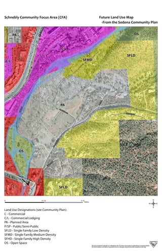
Schnebly CFA Future Land Use Map
- 1. SchneblyHillRd OakCreek ¬«179 ¬«89 quepaque BearWallowLn BurrisLn Quail Ridge Ln GassawayPl ¬«89 PA SFLD C/L C OS OS C C C SFMD SFLD PA C/L C / 0 0.250.125 Miles Future Land Use Map -From the Sedona Community Plan Thismap is designed to provide as-isinformation only.The data is notaccurate to engineeringor surveying standards. The City of Sedona is not liable orresponsible forloss ordamages risingfrom the data containedon this map. Land Use Designations (see Community Plan): C - Commercial C/L - Commercial Lodging PA - Planned Area P/SP - Public/Semi-Public SFLD - Single Family Low Density SFMD - Single Family Medium Density SFHD - Single Family High Density OS - Open Space Schnebly Community Focus Area (CFA)