SanAndres_ManagementUnits
- 1. ! ! ! ! ! ! ! ! ! ! ! ! ! ! ! ! ! ! ! ! ! ! ! ! ! ! ! ! ! ! ! ! ! ! ! ! ! ! ! ! !
!!!!!!!
! ! ! ! ! ! !
!!!!!!
! ! ! ! ! !
!!!!!!!
! ! ! ! ! ! !
!!!!!!
! ! ! !
!!!!!!!!!!!!!!!!!!!!!!!!!!!!!!!!!!!!!!!!!!!!!
! ! ! ! ! ! ! ! ! ! ! ! ! ! ! ! ! ! ! ! ! ! ! ! ! ! ! ! ! ! ! ! !
! ! ! ! ! ! ! ! ! ! ! ! ! ! ! !
!!!!!!!!!!!!!!!!!!!!!!!!!!!!!!!!
!!!!
!!!!!!
!!!!!!!!!!
!!!!!!
! ! ! !
!!!
! ! ! ! ! ! !
!!!!!!!!!!!!!!!!!!!!!!!!!!!!!!!!!!!!!!!!!!
! ! ! ! ! !
!!!!!!!
! ! ! ! ! ! !
!!!!!!!!!!!!!!!!!!!!!!!!!!
! ! ! ! ! !
!!!!!!!!!!!!!!!!!!!!!!!!!!!!!!!!!!!!!!!!!!!!!!!!!!!!!!!!!!!!!!!!!!
! ! ! ! ! !
!!!!!!
! ! ! ! ! !
!!!!!!!!!!!!!!
! ! ! ! ! !
!!!!!!!!!!!!!!!!!!!!
! ! ! ! ! !
!!!!!!!!!!!!!
!!!
!!!!
!!!
!!!!!!!
!!!!!!!!!!!!!!!!!!!!!!!!!!
!!
!!!!!!!!!!!!!!
!!!!!!
!!!!!!!!!!!
!
!!!!!!!!!!
!!
!!!!
!!!
!!!
!!!!!!!
!!!!!!!!!!!!!!!!
!!!!!!!
!!!!!!
!!!!!!!!!!!!!!!!!!!!
!!!!!!!!!!!!!
!!!!!!!!!!!!!!!!!!!!!!!!!!!!!!!!!!!!!!!
!!!!!!!!!!!!!!
!!!!!!!!!!!!!!!!!!!!!!!!!!!!!!!!!!!!!!
!!!!!!!!!!!!!!
!!!!!!!!!!!!!!!!!!!!!!!!!!!!!!!!!!!!!!
!!!!!!!!!!!!!!
!!!!!!!!!!!!!!!!!!!!!!!!!!!!!!!!!!!!!!!
!!!!!!!!! ! ! ! ! ! ! ! !
!!!!!!!!!!!!!!!!!!!!!!!!!!!!!!!!!!!!!!!!
! ! ! ! ! ! ! ! ! ! ! ! !
!!!!!!!!!!!!!!!!!!!!!!!!!!!!!!!!!!!!!!!
! ! ! ! ! ! ! ! ! ! ! ! ! !
!!!!!!!!!!!!!!!!!!!!!!!!!!!!!!!!!!!!!!
! ! ! ! ! ! ! ! ! ! ! ! ! !
!!!!!!!!!!!!!!!!!!!!!!!!!!!!!!!!!!!!!!
! ! ! ! ! ! ! ! ! ! ! ! ! !
!!!!!!!!!!!!!!!!!!!!
!!!!!!!!!!!!
!!!!!!!
!!!!!!!!!!!!!!!!!!!!!!!!!!!!!!!!!!!!!!!!!!!!!
25Lat/Long: 106.596218 W, 32.7611 N
UTM: 350528 E, 3625730 N
1Lat/Long: 106.571748 W, 32.82841 N
UTM: 352932 E, 3633158 N
3Lat/Long: 106.554153 W, 32.77444 N
UTM: 354491 E, 3627150 N
4Lat/Long: 106.56494 W, 32.753947 N
UTM: 353447 E, 3624893 N
5Lat/Long: 106.55755 W, 32.705022 N
UTM: 354059 E, 3619459 N
99Lat/Long: 106.502361 W, 32.53541 N
UTM: 358967 E, 3600579 N
2Lat/Long: 106.567695 W, 32.801425 N
UTM: 353267 E, 3630161 N
10Lat/Long: 106.521029 W, 32.60808 N
UTM: 357329 E, 3608661 N
27Lat/Long: 106.556841 W, 32.57019 N
UTM: 353907 E, 3604509 N
26Lat/Long: 106.59232 W, 32.644249 N
UTM: 350699 E, 3612769 N
9Lat/Long: 106.536286 W, 32.620504 N
UTM: 355917 E, 3610059 N
7Lat/Long: 106.544625 W, 32.661342 N
UTM: 355200 E, 3614598 N
18Lat/Long: 106.585876 W, 32.69717 N
UTM: 351391 E, 3618627 N
8Lat/Long: 106.527096 W, 32.654044 N
UTM: 356833 E, 3613765 N
6Lat/Long: 106.543985 W, 32.712628 N
UTM: 355343 E, 3620283 N
16Lat/Long: 106.595776 W, 32.784916 N
UTM: 350610 E, 3628370 N
12Lat/Long: 106.487387 W, 32.577271 N
UTM: 360438 E, 3605200 N
22Lat/Long: 106.491794 W, 32.612579 N
UTM: 360079 E, 3609121 N
23Lat/Long: 106.507306 W, 32.655438 N
UTM: 358691 E, 3613893 N
24Lat/Long: 106.526531 W, 32.723673 N
UTM: 356997 E, 3621484 N
28Lat/Long: 106.475836 W, 32.684018 N
UTM: 361687 E, 3617020 N
20Lat/Long: 106.546969 W, 32.606332 N
UTM: 354892 E, 3608502 N
21Lat/Long: 106.531812 W, 32.569144 N
UTM: 356254 E, 3604359 N
11Lat/Long: 106.510934 W, 32.581765 N
UTM: 358234 E, 3605730 N
13Lat/Long: 106.500801 W, 32.545453 N
UTM: 359129 E, 3601691 N
14Lat/Long: 106.477221 W, 32.553417 N
UTM: 361355 E, 3602543 N
17Lat/Long: 106.562029 W, 32.741203 N
UTM: 353699 E, 3623476 N
19Lat/Long: 106.559156 W, 32.643596 N
UTM: 353809 E, 3612650 N
15Lat/Long: 106.536255 W, 32.819329 N
UTM: 356239 E, 3632103 N
106°40'0"W
106°40'0"W
106°38'0"W
106°38'0"W
106°36'0"W
106°36'0"W
106°34'0"W
106°34'0"W
106°32'0"W
106°32'0"W
106°30'0"W
106°30'0"W
106°28'0"W
106°28'0"W
106°26'0"W
106°26'0"W
106°24'0"W
106°24'0"W
106°22'0"W
106°22'0"W
106°20'0"W
106°20'0"W
32°32'0"N
32°32'0"N
32°34'0"N
32°34'0"N
32°36'0"N
32°36'0"N
32°38'0"N
32°38'0"N
32°40'0"N
32°40'0"N
32°42'0"N
32°42'0"N
32°44'0"N
32°44'0"N
32°46'0"N
32°46'0"N
32°48'0"N
32°48'0"N
32°50'0"N
32°50'0"N
32°52'0"N
32°52'0"N
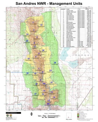
San Andres NWR - Management Units
0 2.5 51.25
Miles
0 2.5 51.25
Kilometers
º
SCALE 1:70,000 Meters
______________________________
San Andres NWR
Projection: UTM, Zone 13N, NAD 27
Base Map: 1981 rectified USGS 100K Topographic Map
Map produced by USFWS: G. Greene, 505-864-4021
August 28, 2006
U.S. Fish and Wildlife Service
Map Location
San Andres NWR
NASA_NotInRefuge
Bighorn Sheep - 31,700.06 acres
Deer - 32,112.56 acres
Buffer Area - 56,290.67 acres
No Burn Area - 167.57 acres
Jornada_NotInRefuge
White Sands Missile Range - 120,270.91 acre MU overlap
** 63,122.81 MU acres are not on refuge land
NUMBER NAME TYPE ACRES
1 Gardner Peak Bighorn Sheep 3042.58
2 Gardner Peak South Bighorn Sheep 2080.96
3 Oñate Peak Bighorn Sheep 4482.04
4 Oñate South Bighorn Sheep 1264.70
5 San Andres NE Bighorn Sheep 2669.80
6 San Andres NW Bighorn Sheep 3074.40
7 San Andres SE Bighorn Sheep 2182.41
8 San Andres SW Bighorn Sheep 1842.25
9 Ash Bighorn Sheep 739.62
10 Black Brushy Bighorn Sheep 1757.43
11 Black Brushy South Bighorn Sheep 2258.30
12 Goat Mountain Bighorn Sheep 2373.59
13 Stinking Spring Bighorn Sheep 1148.29
14 Bennett Mountain Bighorn Sheep 2783.69
15 Dead Mayberry Deer 7842.34
16 Tar Shack Deer 950.34
17 San Andres Canyon Deer 993.20
18 Goldenburg Deer 3121.34
19 Ropes South Deer 2730.91
20 Salt Canyon Deer 982.64
21 San Nicholas Deer 1974.90
22 Black Brushy Fornt Deer 3128.84
23 Coyote Spring Deer 4289.09
24 Dugout Spring Deer 6098.97
25 BUFFER Buffer Area 5098.06
26 BUFFER Buffer Area 7773.87
27 BUFFER Buffer Area 8679.44
28 BUFFER Buffer Area 34739.30
99 NO BURN AREA No Burn Area 167.57