![General Bikeway Plan 55
][
][
][
][
!H
!(
!(
!(
!(
!(
!(
!(
!(
!(
!(
!(
!(
!(
Library &
Ice Rink
erra Valley
Meridian Blvd
Mammoth Creek Park
n Street
SR 203
Welcome
Center
Post Office
Chateau Rd
Tavern Rd
Sierra Nevada Rd
SierraParkRd
LaurelMountainRd
Mammoth Lakes Schools
Cerro Coso
College
31
32
33
34
35
36
37
54
6
9
!(
!(
!(!(
!(
!(
!(
!(
!(
!(
!(
!(
!(
!(
!(
!(
!(
Sierra Valley
Community
Center and Park
North Village Main Street Post Office
M
inar
etRd
Tavern Rd
Sierra Nevada Rd
SierraParkRd
LaurelMountainRd
Forest Trail
32
34
36
40
41
42
49
51
2
3
9
10
16
27
28
The Bluffs
<ToLakeMaryRd
Twin Lakes
Lake Mary
Lake George
Lake Mamie
Horseshoe Lake
Lake Mary
Rd
29
Old Mammoth Road
Town of Mammoth Lakes
General Bikeway Plan Update 2014
*Information on this map is for planning purposes only
Updated 1/28/20140 500 1,000250
Feet
0 1,200 2,400600
Feet
0 500 1,000250
Feet
!( MAP ID LABELS
STREET NETWORK
PROPOSED STREETS
EXISTING CLASS II BIKEWAYS
EXISTING CLASS III
EXISTING CLASS III PROPOSED CLASS II
PLANNED CLASS II BIKE LANES
FUTURE MULTI-USE PATHS
EXISTING CLASS I MULTI-USE PATHS
Routes for pedestrian and bicycle recreation
and commuting
SHARROWS
PARKS AND COMMUNITY FACILITIES
Locations that should be easily accessed by pedestrians
and investment focused
URBAN GROWTH BOUNDARY
][ EXISTING BRIDGE / TUNNEL
[] FUTURE BRIDGE / TUNNEL
!( MAJOR TRANSIT STOP
!H PLANNED ROUNDABOUT
Lakes Basin
North Village and Main Street
Bicycle Network](data:image/gif;base64,R0lGODlhAQABAIAAAAAAAP///yH5BAEAAAAALAAAAAABAAEAAAIBRAA7)
Recommended
Recommended
More Related Content
More from Carson Quam
General Bikeway Plan Updates Routes and Facilities
- 1. General Bikeway Plan 54 !H !H !H !H !H !H !( !( !( !( !( !( !( !( !( !( !( !( !( !( !( !( !( !( !( !( !( !( !( !( !( !( !( !( !( !( !( !( !( !( !( !( !( !( !( !( !( !( !( !( !( !( !( !( !( !( !( !( !( !( 30 31 32 33 34 35 36 37 38 39 40 41 42 43 44 45 47 48 49 50 51 52 54 55 56 53 1 2 3 4 5 6 7 8 9 10 11 12 13 14 15 16 17 18 19 20 21 22 23 24 25 26 27 28 Bicycle Network I 0 0.2 0.40.1 Miles
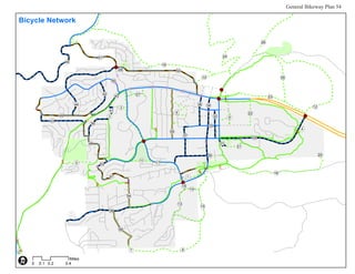
- 2. General Bikeway Plan 55 ][ ][ ][ ][ !H !( !( !( !( !( !( !( !( !( !( !( !( !( Library & Ice Rink erra Valley Meridian Blvd Mammoth Creek Park n Street SR 203 Welcome Center Post Office Chateau Rd Tavern Rd Sierra Nevada Rd SierraParkRd LaurelMountainRd Mammoth Lakes Schools Cerro Coso College 31 32 33 34 35 36 37 54 6 9 !( !( !(!( !( !( !( !( !( !( !( !( !( !( !( !( !( Sierra Valley Community Center and Park North Village Main Street Post Office M inar etRd Tavern Rd Sierra Nevada Rd SierraParkRd LaurelMountainRd Forest Trail 32 34 36 40 41 42 49 51 2 3 9 10 16 27 28 The Bluffs <ToLakeMaryRd Twin Lakes Lake Mary Lake George Lake Mamie Horseshoe Lake Lake Mary Rd 29 Old Mammoth Road Town of Mammoth Lakes General Bikeway Plan Update 2014 *Information on this map is for planning purposes only Updated 1/28/20140 500 1,000250 Feet 0 1,200 2,400600 Feet 0 500 1,000250 Feet !( MAP ID LABELS STREET NETWORK PROPOSED STREETS EXISTING CLASS II BIKEWAYS EXISTING CLASS III EXISTING CLASS III PROPOSED CLASS II PLANNED CLASS II BIKE LANES FUTURE MULTI-USE PATHS EXISTING CLASS I MULTI-USE PATHS Routes for pedestrian and bicycle recreation and commuting SHARROWS PARKS AND COMMUNITY FACILITIES Locations that should be easily accessed by pedestrians and investment focused URBAN GROWTH BOUNDARY ][ EXISTING BRIDGE / TUNNEL [] FUTURE BRIDGE / TUNNEL !( MAJOR TRANSIT STOP !H PLANNED ROUNDABOUT Lakes Basin North Village and Main Street Bicycle Network