More Related Content
What's hot
Enterprise communities, the what, who, why, when, and howEnterprise communities, the what, who, why, when, and howsaastr
Brad_v3
- 1. !(
!(
!(
!(
!(
!(
!(
!(
!(
!(
!(
#*#*#*#*#*#*#*#*#*
#*
#*#*#*#*#*#*#*#*#*#*#*
#*
#*#*#*#*#*#*#*#*#*#*#*#*#*#*#*#*#*#*#*#*#*#*#*#*#*#*#*#*#*#*#*#*#*#*#*#*#*#*#*#*#*#*#*#*#*#*#*#*#*#*#*#*
#*
#*#*#*#*#*#*#*#*#*#*#*#*#*#*#*#*#*#*#*#*#*#*#*#*#*#*#*#*#*#*#*#*#*
#*
#*#*#*
#*
#*
#*
#*#*
#*
#*#* #*#*#*#*
#*
#*#*
#*
#*
#*
#*#*
#*
#* #*#*
#*
#*
#*
#*#*
#*
#*
#*
#*
#*
#*
#*
#*
#*
#*
#*
#*
#*
#*
#*
#*
#*
#*
#*
#*
#*
#*
#*
#*
#*
#*
#*
#*
#*
#*
#*
#*
#*
#*
#*
#*
#*
#*
#*
#*
#*#*#*#*#*#*#*#*#*#*#*#*#*#*#*#*#*#*#*#*#*#*#*
#*
#*#*#*
#*
#*
#*#*#*#*
#*
#*#*#*#*
#*
#*#*#*#*#*#*#*#*#*
#*
#*#*#*
#*
#*
#*
#*
#*
#*
#*
#*
#*
#*
#*
#*
#*
#*
#*#*
#*
#*
#*
#*
#*#*
#*
#*
#*#*
#*
#*#*#*#*#*#*#*#*#*#*#*#*#*#*
#*#*
#*
#*#*#*#*#*
#*
#*
#*#*
#*#*
#*
#*#*#*#*#*
#*
#*
#*
#*
#*#*
#*#*
#*
Prince
George
Calgary
Lloydminster
Kamloops
Fort
McMurray
Fort St.
John
Lethbridge
Edmonton
L a k e
A t h a b a s c a
Township 1
Township 100
Township 50
6thMeridian
5thMeridian
4thMeridian
Copyright:© 2014 Esri
108°0'0"W
110°0'0"W
110°0'0"W
112°0'0"W
112°0'0"W
114°0'0"W
114°0'0"W
116°0'0"W
116°0'0"W
118°0'0"W
118°0'0"W
120°0'0"W
120°0'0"W
122°0'0"W
122°0'0"W124°0'0"W
60°0'0"N
60°0'0"N
58°20'0"N
58°20'0"N
56°40'0"N
56°40'0"N
55°0'0"N
55°0'0"N
53°20'0"N
53°20'0"N
51°40'0"N
51°40'0"N
50°0'0"N
50°0'0"N
ON
YT
SK
NT
NU
BC AB
MB
Copyright:© 2014 Esri,
Sources: Esri, USGS, NOAA
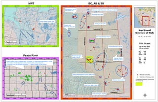
Brad Powell
Overview of Wells
AB, BC, SK & NWT
")
")
")
#*#*
#*
Inuvik
Aklavik
Tuktoyaktuk
M
ackenzie
River
M
ackenzie
River
MackenzieRiver
Copyright:© 2014 Esri, Sources: Esri, DeLorme, USGS,
NPS
133°0'0"W
133°0'0"W
134°0'0"W
134°0'0"W
135°0'0"W
135°0'0"W
136°0'0"W
136°0'0"W137°0'0"W
132°0'0"W
69°20'0"N
69°0'0"N
69°0'0"N
68°40'0"N
68°40'0"N
68°20'0"N
0 10 205
Kilometers
NWT
0 10 205
Kilometers
#*
#*
#*
#*#*#*#*
#*
#*
#*
#*#*
#*
#*#*
#*
#*
#*
#*#*#*
#*
#*#*
#*#*
#* #*
#* #*#*
#* #*
#*#*
#* #*
#* #*
#*#*#*
#*#*
#*
#*
#*#*#*#*
#*
#*#*
#*
#*#*
#*
#*
#*
#* #*#*#*
#*#*
#*#* #*
#*
#*
#*
#*
#*#*
#*
#*#*#*
#*
#*#*
#*
#*
#*
#*
#*
#*#*
#*
#*#*
#*#*#*
#*
#*
#*
#*#*#*
#*#*
#*#*#* #*
#*#*
#*
#*
#*
#*
#*
#*
#*
#* #*
#*
#*
#*
#*
#*
#*
#*
#*
#*
#*
#*
#*
#*
#*
#*#*
#*
Cadotte
River
SouthHeart
River
Cadotte River
Heart
River
South
Heart
River
Lubicon
Lake
PeaceRiver
CadotteLake
Copyright:© 2014 Esri
R.19W5 R.16W5 R.15W5
R.17W5 R.16W5
R.14W5R.17W5 R.13W5R.18W5R.20W5
R.18W5R.20W5 R.13W5R.19W5 R.14W5R.15W5
T.83
T.82T.82
T.85 T.85
T.83
T.86
T.87 T.87
T.84T.84
T.86
Peace River
0 10 205
Kilometers
#* Wellsite Consulting
#* Operations Geology Lead
µ
Belly River gas, 8 wells
Mississipian Gas &
Jean Marie HZ
Deep Mississippian/Turner Valley HZ
Thermal SAGD,
McMurray sand
Central Alberta oil & gas
Deep Basin gas,
mostly CRDM
See Inset "Peace River"
Triassic and
Devonian oil & gas
Devonian oil & gas
Cameron Hills Devonian oil & gas, 15 wells
BLSK gas, 51 wells
Bow Island gas, 5 wells
Shallow Mannville oil
Alklak deltaic sands, gas
Shell's Peace River/ Cliffdale field, 178 wells, VT observation/delineation, coring,
multi-lateral HZ development wells, thermal and cold production
of bitumen from the Bluesky formation, 1 million meters of hole drilled
BC, AB & SK
Production Geology Focus area
(Cretaceous)
TOTAL 330 wells
178 as OPS GEO
152 as wellsite
HZ 128
DIR 32
VERT 170
BC 20
AB 285
SK 7
NWT 18