1. P. Okubo1
, A. J. Hotovec-Ellis2
, W. Thelen1
, P. Bodin2
, J. Vidale2
, and A. Sadjadpour3
P. Okubo1
, A. J. Hotovec-Ellis2
, W. Thelen1
, P. Bodin2
, J. Vidale2
, and A. Sadjadpour3
1
U.S. Geological Survey, Hawaiian Volcano Observatory, 2
Pacific Northwest Seismic Network,University of Washington, 3
Thirty Meter Telescope1
U.S. Geological Survey, Hawaiian Volcano Observatory, 2
Pacific Northwest Seismic Network,University of Washington, 3
Thirty Meter Telescope
EARLY STATUS OF EARTHQUAKE EARLY
WARNING ON THE ISLAND OF HAWAI`I
CURRENT EARLY WARNING POTENTIAL
NEXT STEPS
ABSTRACT
Earthquakes, including large damaging events, are as central to the geologic evolution of the Island of Hawai`i as its more famous volcanic eruptions and lava flows. Increasing
and expanding development of facilities and infrastructure on the island continues to increase exposure and risk associated with strong ground shaking resulting from future large
local earthquakes. Damaging earthquakes over the last fifty years have shaken the most heavily developed areas and critical infrastructure of the island to levels corresponding to
at least Modified Mercalli Intensity VII. Hawai`i’s most recent damaging earthquakes, the M6.7 Kiholo Bay and M6.0 Mahukona earthquakes, struck within seven minutes of one
another off of the northwest coast of the island in October 2006. These earthquakes resulted in damage at all thirteen of the telescopes near the summit of Mauna Kea that led
to gaps in telescope operations ranging from days up to four months.
With the experiences of 2006 and Hawai`i’s history of damaging earthquakes, we have begun a study to explore the feasibility of implementing earthquake early warning
systems to provide advanced warnings to the Thirty Meter Telescope of imminent strong ground shaking from future local earthquakes. One of the major challenges for earthquake
early warning in Hawai`i is the variety of earthquake sources, from shallow crustal faults to deeper mantle sources, including the basal décollement separating the volcanic pile from
the ancient oceanic crust. Infrastructure on the Island of Hawai`i may only be tens of kilometers from these sources, allowing warning times of only 20 s or less. We assess the
capability of the current seismic network to produce alerts for major historic earthquakes, and we will provide recommendations for upgrades to improve performance.
SEISMIC HAZARD
156.0ºW 155.5ºW 155.0ºW
19.0ºN19.5ºN20.0ºN
66
66
66
88
88
88
88
1010
1010
1010
1010
1010
1212
1212
1212
1212
1414
1414
1414
1414
1616
1616
1616
1818
1818
1818
2020
2020
Source at 40 km Depth, Networked Approach
156.0ºW 155.5ºW 155.0ºW
19.0ºN19.5ºN20.0ºN
00
22
22 22
44
44
44
66
66
6666
88
88
88
88
88
1010
1010
1010
1010
1010
1212
1212
1212
1212
1414
1414
1414
1414
1616
1616
1616
1616
1818
1818
1818
2020 2020
2020
2222
2222
Source at 10 km Depth, Networked Approach
156.0ºW 155.5ºW 155.0ºW
19.0ºN19.5ºN20.0ºN
66
66
66
88
88
88
88
1010
1010
1010
1010
1212
1212
14141414
Source at 40 km Depth, On-Site Approach
156.0ºW 155.5ºW 155.0ºW
19.0ºN19.5ºN20.0ºN
44
44
44
66
66
66
88
88
88
88
1010
1010
1010
1010
1212
1212
1212
14141414
Source at 10 km Depth, On-Site Approach
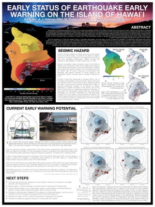
0 20 40 60 km
Mauna Kea Observatories
Contour of Warning Time
Data window for ElarmS
Approx. time to solution
Seismometer
Major earthquake (M≥5.5)
since 1973
Maps of maxmimum “warning” time from an earthquake at a given point to Mauna
Kea Observatories. Warning time is defined as the amount of time between
detection of the earthquake and arrival of the S-wave. For the “on-site” approach
(top row), detection is using a hypothetical single station at the summit of Mauna
Kea; for the “networked” approach (bottom row), detection is defined as the arrival
of the P-wave to the 4th closest station to the earthquake. Shading represents
time used to calculate a window for magnitude (4 seconds) and a conservative
estimate of time to produce an alert accounting for some network latency (8
seconds). Plotted earthquakes are within 5 km of the hypothetical source depth.
1868
1868
1918
1919
1929
1941
1950
1951
1951
1952
1954
1955
1962
1973
19751979
1983
1989
2006
2006
50 km
Mauna Kea
Observatories
Large (M5.5+) historical earthquakes around the Island of Hawai`i
and composite Modified Mercalli Intensities for the island, compiled
from historical accounts. Figure adapted from Wyss and Koyanagi,
1992, USGS Bulletin 2006, and Klein and others, 2001.
I II III IV V VI VII VIII IX X X+
Modified Mercalli Intensity
0 50 100 150 200
%g
1818
1212
1818
2424
2424 3030
3030
3636
3636
3636
42424242
4848
4848
2020
2020
1010
3030
4040
5050
Kiholo Bay
M6.7
Seismic Hazard
(1998)
Ka`u Scenario
M8.0
Above: Seismic hazard in peak
ground acceleration (PGA) with
2% exceedance in 50 years from
a 1998 assessment.
Right: PGA ShakeMaps for the
M6.7 Kiholo Bay earthquake and
a hypothetical recurrance of the
M7.9 Ka`u earthquake. Contours
for both maps are in %g.
Seismic hazards threatening Hawai`i rank among the highest
across the United States. In particular the Island of Hawai`i,
because of its active volcanism, has experienced numerous
large and damaging earthquakes. Written records and
catalogs of earthquakes in Hawai`i extend back to 1823.
Modern probabilistic seismic hazards maps for the State of
Hawai`i were computed in 1998. They closely reflect Hawai`i’s
actual earthquake experience, with the entire Island of Hawai`i
facing significant seismic hazards. The southeastern flank of
the island, with its active volcanoes, is associated with
extremely high seismic hazards. A USGS update to the
probabilistic seismic hazards maps for Hawai`i is planned for
2015.
The M6.7 Kiholo Bay earthquake in October 2006 is one of
the largest earthquakes to have struck the nation during the
past decade. Seven minutes later a M6.0 aftershock shook
the island. These events produced roughly $200 million in
reported earthquake damage on the Island of Hawai`i.
State-wide, a system shutdown of the electric grid on the
island of Oahu led to an outage there lasting for more than 12
hours after the earthquakes. Shown with the 2006 Kiholo
ShakeMap is a “scenario” ShakeMap for a M8 earthquake
centered in the Ka`u District, to the southwest of Kilauea. This
scenario was computed for planning purposes, as an analog
to the 1868 M7.9 (est) Ka`u earthquake, thus far the largest
recorded earthquake in Hawai`i.
Over the past few decades, development of the astronomical observatories atop Mauna Kea on the
Island of Hawai`i has resulted in a very specialized inventory comprised of the Mauna Kea telescopes.
The 2006 earthquakes significantly impacted telescope operations, including loss of observing times.
In light of these experiences and in anticipation of the Thirty Meter Telescope (TMT), we have begun a
study to explore the feasibility of Earthquake Early Warning to the TMT based on current EEW
implementation along the West Coast of the United States.
TMT and the other Mauna Kea Observatory telescopes require an EEW system that rapidly determines
if strong shaking is imminent, with increased speed at the cost of accuracy in magnitude and location.
TMT has a high tolerance for false alerts, with downtime on the order of 10 to 15 minutes.
Automated response to an alert would stop the telescope from slewing* by braking. The telescope is
also vulnerable during maintence, e.g., the removal of mirrors via crane. EEW would also be useful during
construction.
Left: Current TMT structural design. Although the design includes isolation spring dampers and
lateral/uplift restraints, further damange to the telescope could be prevented through early warning.
Right: Concrete grout damage to the Subaru telescope in the 2006 Kiholo Bay earthquake.
• Purchase new servers and upgrade the current seismic network on the island to use digital
telemetry with reduced latency
• Reduce gaps in network coverage to provide maximum warning time to Mauna Kea
• Further evaluate design of an on-site system (single or small network of accelerometers) as
backup in case network-based EEW system fails to produce an alert
• Evaluate the effectiveness of different EEW systems on smaller earthquakes, over time; some
potential to test recent large earthquakes like Kiholo Bay and aftershock
• Integrate the system with the California/Cascadia and Japanese EEW systems
• Evaluate the additional upgrades required for a state-wide EEW system
* the process of rotating a telescope to observe a different region of the sky