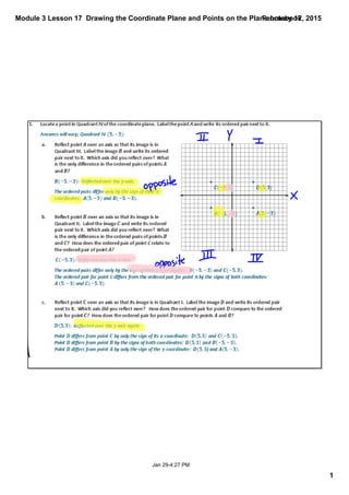
This document provides a lesson on drawing coordinate planes and plotting points on them. It includes examples of drawing planes with different scales for the axes and locating points. The lesson teaches students to first assess the range of values in a set of points before setting the scale, and how to determine if the scale should be increased or decreased to accommodate all points. Labeling the axes and using the correct scale are emphasized as important for accurately interpreting graphs.
15. Module 3 Lesson 17 Drawing the Coordinate Plane and Points on the Plane.notebook
15
February 12, 2015
Aug 268:21 PM
Closing
Please take out your exit ticket for Lesson 17, close your
binder, and complete the exit ticket. This will be collected.
Lesson Summary
§ The axes of the coordinate plane must be drawn using a straight edge and labeled x (horizontal
axis) and y (vertical axis).
§ Before assigning a scale to the axes it is important to assess the range of values found in a set of
points, as well as the number of grid lines available. This will allow you to determine if the number of
units per grid line should be increased or decreased so that all points can be represented on the
coordinate plane that you construct.
§ Why is it important to label the axes when setting up a coordinate plane?
ú So that the person viewing the graph knows which axis represents which coordinate
and also so they know what scale is being used. If a person does not know the scale being
used, they will likely misinterpret the graph.
§ Why shouldn’t you draw and label the entire coordinate grid before looking at the
points to be graphed?
ú Looking at the range of values in a given set of points allows you to decide whether or
not a change of scale is necessary (or desired). If you set a scale before observing the given
values, you will likely have to change the scale on your axes.