25 acres +/- of Commercial and Multi Family land with 864 ft frontage on Hwy 79 and over 1000 ft on the bay. Future land use of Marina Village available, zoning entitlements in place. Location is 4 miles north of beaches, and 3 miles south of new International Airport on Hwy 79.
1. Buchanan Landings
West Bay, FL 2008
Lisa Felix, Broker
Latitudes Realty of West Bay
850-819-4961
LatitudeLisa@Yahoo.com
www.InvestInWestBay.com
2. Executive Summary
• Approximately 26 +/- acres of Bay-Front Property on West
Bay. (* Master survey is 24.5 Acres, additional adjacent
parcels may been added)
• 800 ft +/- on Hwy 79. Location is ~ 2 Miles South of
projected main entrance to New International Airport.
Ingress and Egress at School Rd.
Site is 4 miles North of Panama City Beach.
• 1000 ft +/- Waterfront on West Bay.
• Zoning. Current zoning is 50% Commercial + 50%
Residential Multi-family.
• Zoning. Future Land use in accordance with Sector Area
Plan Overlay Map (approved) West Bay Center East,
described as Marina Village.
• Density. 15 Units per acre. Applies to residential use only.
Commercial use as Hotel limited only to floor area ratio’s
(%200).
• Public Water Source. Available
• Public Sewer Source. Attainable
• Feasibility on hand. Boundary, Tree & Topo Surveys,
Environmental Phase I (clean), Wetland Delineation
Study, Engineered drawings
3. I n t r o d u c t i o n.
Buchanan Landings is an assemblage of 19 Property owners who are all in
agreement to sell at their own various price-points. There is no unified
price per acre. These parcels have been contracted with one entity
(West Bay Neighborhood Partners LLC) for the purpose of negotiating and
assignment to an end user/developer. There has been no assignment fee
incorporated into the sales price.
There are additional and adjacent properties available that are listed for
sale, which will complete the assemblage at the time of contract.
The value in this assemblage is in it’s location, natural beauty and it’s
Future Land Use.
L o c a t i o n.
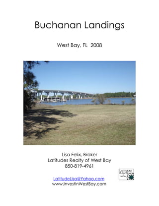
This property is uniquely located within full visibility of the Buchanan Bridge
on Highway 79, which is the main traffic artery leading from this area’s
new International Airport (scheduled for completion in 2010), and
Panama City Beach, widely known as “The Worlds Most Beautiful
Beaches”. The Buchanan Bridge has recently completed the sister bridge,
completing the 4 to 6 lane traffic corridor crossing the Inter-coastal
waterway and connecting the Beaches to the areas largest future
employment center.
Picture taken from Buchanan Bridge
4. The proximity of this location to the International Airport,
regional employment centers, residential areas and tourist
corridor’s along the Beaches are central to it’s uniqueness and
value to the end-user.
Approved Overlay Map of West Bay Sector Area Plan.
Make a note of the green “preservation area” prescribed by
this overlay map. This indicates the scarcity waterfront area
where development will be allowable within the Sector Area
Plan.
5. Additionally, the property is located at approximately the half-
way point, along the Inter-coastal Waterway between the
Choctawhatchee Bay, of Destin and Fort Walton areas, and
the St. Andrews Bay in Panama City and Panama City Beach.
There are no Gulf Inlets between these 2 bays, only the Inter-
Coastal waterway serves to connect them.
The Site is also in direct line with Sidecamp Road, which is a
connector road between West Bay and the Beaches of South
Walton County, with the prestigious communities of Rosemary
Beach, Alys Beach, Seaside, Camp Creek, Seacrest, and the
like can be found. This is important to note because of the
demand associated with a private marina facility as it is relative
to the proximity of these communities.
6. N a t u r a l B e a u t y.
The natural beauty of this site is not to be overlooked. This
property is primarily uplands with gorgeous oaks and natural
topography.
Beautiful Oaks
create anchors for
landscaping.
This walk-over bridge
crosses a natural,
privately owned canal
located on the West-
side of the property.
This feature will allow
Deeded boat-slips with
it’s enlargement; no
state jurisdiction.
7. We have had the shores of this property evaluated by an
environmental permitting company, who reported no sea grass
beds, adequate distance from shellfish harvesting areas, and
positive bathometric results. Various feasibility reports are
available upon request.
Z o n i n g.
This property has been recently up-zoned to accommodate a
C-3 zoning designation on approximately one half of the
property, and an R-5 designation on the remainder of the
property. This will allow development as a Marina, Hotel, and
condominium site with a significant amount of retail possibilities.
Red = Commercial (Floor area ratios = 200%)
Orange = R-5 Residential Multi-family (density = 15/acre)
8. Future Land Use, as indicated by the Sector Overlay Map on
page 4 is designated as West Bay Center East. The
designations indicted by the various colors on the overlay map
apply only to properties owned by St. Joe , until and unless the
private land-owners apply for the Land Use that corresponds
with their location on the map. It is presumed that land use will
be awarded in concert with Future Land Use that is already
approved as part of the overlay. Below is an exert from the Bay
County Planning and Zoning’s description of uses associated
with West Bay Center East. The full comprehensive plan can be
found at http://www.panamacity-
fl.gov/planning_zoning_information.htm .
9. Engineered Drawings demonstrate potential as a Marina
Village concept.
R e c e n t D e v e l o p m e n t s.
As of November 2008, the construction phase of the Bay
County International Airport is reported to be 3-4 months ahead
of schedule. Transportation corridor’s along Hwy 79 are being
4-laned, the newly expanded Buchanan Bridge is completed
and we are having information dripped to us almost daily
concerning new roads, new developments in the employment
center, and the general unfolding of plans as they pertain to
our area. Additionally, The News Herald has recently reported
10. (11-08-08) that a Legacy Carrier is being negotiated as a Hub
for our airport, and Federal Express is expected to be a major
cargo carrier and provide substantial jobs to the employment
center.
Below is an exert from a map provided to the Walton County
Chamber of Commerce this week describing 2 new roads,
presumably toll roads, that will provide access to the new
airport. These roads are reported to be completed in 2010 and
will provide direct access from the airport to Hwy 98 and Hwy
331.
11. In Summary
As time progresses, we are seeing a surge of activity related to
the area’s in and around West Bay. With the troubling
economic climate of late, there are many deals to be had;
however with announcements unfolding daily as to the future
of our area, the window of opportunity for investment in a
Buyers Market may be drawing to a close.
We are eager to negotiate a deal on the property described in
this report, although the individual property owners have
varying degrees of motivation, it can be done with the right
developer and the right development plan. It should also be
noted that occupancy after the sale will be necessary on some
of the parcels, but post occupancy may run concurrent with
permitting and development orders and may also be limited by
agreement.
It should be disclosed that the author of this Marketing
presentation is one of the individual property owners
composing this assemblage, is directly related to several of the
other property owners and is also a partner with the entity
currently holding assignable contracts.
It is our intent to cooperate with other Brokers participating in
the sale as a Buyers representative and pay a 2% commission
at the time of sale, provided that this is made a term of each
individual agreement with the property owners.
We invite anyone serious about investing in this unique
development opportunity to visit the site; we are prepared to
make all feasibility currently available to qualified prospective
buyers.
*All information contained in this report is believed to be true
and correct, however should be independently verified.