2. Applying GIS Technology to Law Enforcement
The Geographic Advantage for Proactive Policing and Informed Response
Law enforcement means problem solving. As a commander, an
officer responding to a scene, or an analyst piecing together
elements of a crime pattern or trend, you make critical decisions
every day. These decisions have a direct impact on citizens and
on fellow law enforcement personnel.
Geographic information system (GIS) technology can provide the
geographic advantage for law enforcement enterprise informa-
tion systems by turning data into actionable knowledge.
A GIS combines layers of data about a location to give you a
better understanding of that location and what is occurring
around it. The data and information you combine depends on
your purpose, whether realigning response zones for better
resource allocation, analyzing crimes to detect emerging pat-
terns, examining the best locations to conduct surveillance for a
recent crime series, or establishing a perimeter for a crime scene
or natural disaster. GIS technology dynamically combines many
layers in a relevant display, getting the right data and informa-
tion into the hands of those who need it. The Hartford, Connecticut, Police Department uses ArcGIS ® and
ModelBuilder™ to support intelligence-led policing. This has allowed the
department to effectively change, in a positive manner, its community
policing initiatives at the neighborhood level.
Incident Analysis
Gang Hazards
Resource Allocation
Offender Tracking
Facility Monitoring
Station Locations
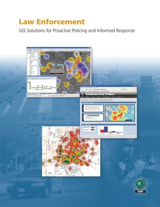
Crime density and
hot spot analysis by
the Lincoln, Nebraska, Real World
Police Department.
3. GIS for Intelligence-Led Policing
Prevent and Respond Safely and Effectively
A new trend is emerging among forward-thinking agencies, with
the power of GIS transforming the way police protect and serve
your communities.
GIS provides an information-based method supporting all roles
and aspects of law enforcement.
Field Personnel
Field personnel can access intelligent information from their
mobile devices to identify suspicious activity, enhance field inves-
tigations, access suspect information, and easily perform crime
analysis.
ArcGIS is used to determine the risk level of sex offender activity in
Riverside County, California.
Law enforcement can use GIS solutions to
• Determine optimal locations for deploying resources.
• Analyze the dynamics of an incident in progress to make
informed decisions and operational adjustments.
• Identify and examine suspicious activity and threats.
• Enhance officer safety and effectiveness by providing
information and awareness of repeat incidents.
• Target repeat 911 call locations.
• Perform resource analysis and allocation.
The Arizona Counter Terrorism Information Center applies GIS for
critical infrastructure assessment and protection. • Develop a crime scene log to ensure the integrity of an
investigation.
• Exchange information with a neighboring jurisdiction or a
Incident Commanders jurisdiction half a world away.
Incident commanders can use GIS to understand trends, make
critical decisions when crime spikes, and collaborate with other
law enforcement agencies.
Crime and Intelligence Analysts
A crime or intelligence analyst can use sophisticated tools to
support better operational decisions and to address short-term
tactical and long-term strategic issues.
Chief of Police or Sheriff
GIS can provide a chief or sheriff with a comprehensive view
for long-term decision making. They can also look at predictive
crime models for developing comprehensive strategic plans to
support personnel.
Twenty-four-hour crime density for a three-month period; total number
of crimes = 375. By the South Georgia Regional Development Center.
4. GIS and the Law Enforcement Enterprise
Working across Agencies, Jurisdictions, and Borders
At the core of an enterprise GIS platform is the ability to use a
geographic approach throughout the organization to work more
efficiently and effectively in meeting the challenges you face.
Better data management leads to better resource management.
Knowing more about crimes and hazards or threats creates more
opportunities for proactive policing and crime prevention. New
methods to target crime can identify new operational needs.
From the desktop to the field, you can benefit by applying the
geographic advantage to the law enforcement enterprise.
The Redlands, California, Police Department uses
ArcGIS to display a density hot spot analysis of
auto thefts.
Enterprise GIS supports the law enforcement mission by
providing the foundation to address four key needs: ArcGIS Server – ArcGIS Explorer
• Operational Awareness—Supporting a comprehensive,
ArcInfo/Partner Solutions
Executive Dashboard
relevant view into your agency’s activities
Partner Solutions
ArcGIS Desktop –
ArcGIS Server/
Routing
• Information Integration and Analysis—Managing data
Operational Awareness
effectively and reducing information overload
Information Integration and Analysis
Analysis
Crime
Tracking
• Strategic and Tactical Planning—Creating more ArcGIS Server
AVL/
opportunities for proactive policing through analytic tools
Field Mobility
• Field Mobility—Providing a platform for data and
Awareness
information exchange into and out of the field
Field
Intelligence Analysis
Mobile/Partner Solutions
Law Enforcement
Data Fusion/
Partner Solutions
Data Model
ArcGIS Server –
ArcGIS Server/
Integration
MDT/MDC
Strategic and Tactical Planning
Resource Community COMPSTAT
Management Corrections
ArcGIS Server ArcGIS Desktop – ArcGIS Desktop –
ArcInfo ArcGIS Server
Information Core Key Technology
and Systems Business Business Approach
Framework Capabilities Solutions
5. The Enterprise Geographic Advantage
Turning Data into Actionable Intelligence
ESRI® software and technology is used by law enforcement agen- Financial and Electronic Crimes
cies in hundreds of applications throughout the world, with ESRI
• Monitor and highlight clusters of suspicious transactions
and ESRI business partners providing GIS solutions for every need.
involving potential credit card fraud and food stamp fraud.
• Model flows of financial activity between individuals to spot
potential criminal dealings or terrorist activity.
• Develop intelligent tools to spot sudden changes in a suspect’s
financial picture.
Criminal Intelligence and Analysis
• Analyze crime patterns and provide geographic profiling.
• Map crime and law enforcement timelines and activity flows.
• Perform strategic analysis by mapping threat assessment and
flagging areas of concern.
Public Information
• Share information with the general public about emerging
problems or threats.
• Enlist the support and feedback of community watch and
Critical infrastructure identification and risk assessment can be citizen advisory councils.
performed using ArcGIS. • Advise the public of convicted sex offenders residing in their
communities.
Crime and Investigative Analysis
Corrections, Probation, and Parole
• Leverage and fuse spatial data to a wide variety of traditional
• Map crime patterns and trends among the inmate population.
law enforcement data sources.
• Visualize networks and associations among inmates that foster
• Provide contextual information for a more informed response.
crime problems.
• Identify and link related or seemingly unrelated crime patterns
• Identify resource gaps and support effective reallocation
and trends.
processes.
CompStat and Accountability Methods
• Implement plans to reduce crime and improve quality of life.
• Support collaboration through informed problem solving for
all levels of law enforcement.
• Ensure coordination and eliminate duplicative efforts.
Community Policing
• Integrate demographic, housing, business, and other data for
understanding neighborhoods.
• Site community policing outreach offices in proximity to
populations at risk.
• Perform a multitude of tasks and analyses using historical
socioeconomic data.
E-911/Communications
• Quickly locate and map emergency call locations.
• Display the current locations of public safety vehicles for
efficient dispatch.
The Lincoln, Nebraska, Police Department uses ArcGIS to perform
• Display public safety resource locations for incident 3D density analysis of narcotics-related crimes.
management and command and control.