This document is a tube map of the London Underground system. It shows all the lines and stations on the network. Additional information is provided on some stations, including accessibility information, station closures or changes to hours of operation. The key at the bottom explains the different lines by color and symbols are used to indicate facilities at stations like lifts or interchanges.
This diagram shows the London Underground and Overground rail network. It includes all station names and color-coded lines. Some stations are noted as being step-free, closed on certain days/times, or requiring a change at another station for certain destinations. Special fares may apply on some lines.
This document is a diagram of the London Underground map from December 2013. It shows all the tube stations and color-coded lines connecting them. There are also notes providing information on station facilities, accessibility, and planned closures or service changes for some stations. The key at the bottom explains the symbols and lines.
Big Ben is the nickname for the Great Bell of the clock located in the Elizabeth Tower in London. The clock tower was designed by architect Charles Barry as part of a new Palace of Westminster built after a fire in 1834. Augustus Pugin assisted with the detailed Gothic design of the clock tower. The clock mechanism was designed by Edmund Beckett Denison and installed by Edward John Dent. The original 16-ton bell cracked in 1857 after several years of use and was recast into the current 13.5 ton bell that continues to keep time today.
The document discusses the history of maps for London's underground transit system. It traces the development of maps from 1906 to the 1990s, highlighting some key events. In the 1930s, Harry Beck developed the first diagrammatic map that simplified the network into clear lines and shapes. This new topological map design proved very successful and became the standard format still used today. The document then lists various map editions produced over the decades that built upon Beck's original innovative design.
Paper Maps are of the past new mobile interactive maps is present and the future. Map the Xperience designs recreational maps for outdoor users. No internet connection is needed to work the map on your phone. Check out our You Tube tutorial on how to get the App and the Map.
The document discusses various topics related to maps including magical maps, live events featuring maps, different types of maps showing animals, cities, emotions, and social media, as well as ghost stories and new city experiences. It also provides contact information for Ronald Lenz from Waag Society and 7scenes.
This document discusses key concepts in operations management including demand management, inventory management, capacity management, sales and operations planning, information systems like ERP and MRP, manufacturing leadership, demand driven theory of constraints, lean business processes, servitization, and how operations management can create synergy and public policy benefits.
This document is a collection of images related to London's Underground transportation system from 1908 to 2009. It includes historical pocket maps, posters, cartoons, drawings and artworks that feature the Underground over the past century. The images trace the evolution of Harry Beck's iconic diagrammatic tube map as well as other artistic interpretations of the Underground network through different eras.
1. The document is a tube map showing London's underground rail system with 9 numbered lines.
2. Special fares may apply on some lines and services have different operating hours than normal, such as the Waterloo and City line only running on weekdays and closing on Sundays and public holidays.
3. During the 2012 London Olympics, the Waterloo and City line will have extended hours of operation from 0621-0100 Mondays to Fridays and 0802-0100 Saturdays and Sundays.
A selection of great information graphics from various sources on the web. As the quality is not so good after having been optimized for slideshare.net, I advice you to download it. The images are of high quality in the downloaded version of the presentation.
Tube map metaphor for Manchester Metropolitan University's data warehouse, illustrating different lines of enquiry that the data warehouse will support. “Stations” that join lines of enquiry highlight where common identifiers are needed in the data. Map has been updated recently to reflect plans to integrate with HR Analytics work.
This document summarizes how Abby Covert teaches information architecture to design students at art schools. She teaches them strategies for identifying stakeholders, documenting consensus on goals, and conducting contextual design. Students learn about using diagrams and maps to think with others, such as swim lane diagrams, journey maps, and flow charts. Exercises help students explore meaning in communication and creating taxonomic structures. The goal is to provide students with skills in information architecture that can benefit their design work.
This document outlines features, improvements, and scope definitions for multiple product roadmaps. It includes smart features, improvements to registration processes, new systems like robotic automation, analytics integration, and keeping clients happy. The document concludes by explaining new roadmapping methodologies and scope definitions for the next 12 month periods.
This document is a map of the London Underground and transport system for August 2022. It provides an overview of all the tube and train lines operating in London, including the locations of stations and interchange points. Key symbols indicate features like step-free access, interchanges between lines, and stations outside of fare zones. Notes on some stations provide information on upcoming changes or limited accessibility. The map also includes an index of all stations with grid references.
This document is a map of the London Underground and rail network for October 2022. It shows all tube and rail lines in zones 1-9, including the locations of stations and interchange points. Key symbols are explained, such as step-free access and facilities available. Notes provide information on night services and special fares that apply on some lines.
The document is a map of the London public transportation system from Transport for London from May 2022. It provides information on upcoming changes and station notes. Key upcoming changes include the opening of the new Elizabeth line station at Bond Street and the opening of the Barking Riverside extension. Station notes provide information on temporary closures or changes to access at specific stations through June 2022.
This document provides information about toilet facilities located at various London Underground stations, including:
- Stations that have toilet facilities and whether they are inside or outside the ticket gates
- Stations that charge a fee for using the toilets and how much the fee is
- Stations that have baby changing facilities located within the toilets
- Information on toilet locations that are not managed by London Underground
This document is a map of Bath, England showing various streets, landmarks, parks, and transportation options. Key locations include the Royal Crescent, Roman Baths, Bath Abbey, Royal Victoria Park, Sydney Gardens, and Bath Spa train station. The map also provides information on tourist services, parking, and a map key explaining symbols.
The document is a map showing the proposed redevelopment plan for the Port Lands area of Toronto, Canada. Key elements of the plan include removing an elevated expressway and replacing it with a new boulevard, building a new promontory park through land reclamation, constructing new bridges and roads including a new Lake Shore Boulevard, and adding parks, trails, and facilities for recreation, transportation, and managing sediment and debris.
This document contains a map of Queenstown, New Zealand showing various streets, points of interest, walking tracks, and directions to nearby locations. It includes the town centre area with streets, parks, services, and attractions. Broader maps show the local area around Queenstown including roads, rivers, ski fields, towns and directions to places like the airport, Remarkables shopping centre, Arrowtown, and wineries.
CNW Electrical Wholesale and Energy Solutions is the largest Australian-owned independent electrical wholesaler, with outlets across every Australian state and territory. They provide a wide range of high-quality electrical products and services through their extensive branch network and tailor solutions to local needs with assistance from experienced staff. CNW delivers electrical products and solutions to a broad range of commercial, industrial, residential, and infrastructure projects nationally and internationally.
This document provides a map and crowding overview of scheduled train services in London during the afternoon peak hour. It shows color-coded crowding levels on different train lines from 0-4+ passengers per square meter. Areas in red are the most crowded with significant queuing likely, while green areas have some standing space available. The map covers stations throughout London and surrounding areas.
This document appears to be a map of the New York City subway system. It lists over 200 subway stations and stops across the five boroughs (Brooklyn, Queens, Manhattan, The Bronx, Staten Island) and shows the lines that connect them. Key transfer points like Times Square, Grand Central, Penn Station, and Atlantic Ave-Barclays Center are indicated. Commuter rail connections to Long Island Rail Road and Metro North are also noted.
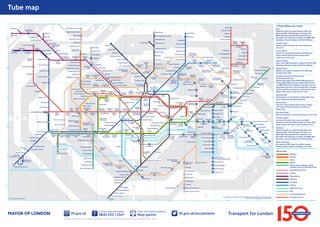
1. Tube map
1
Chesham
9
Chalfont &
Latimer
2
8
Watford
3
4
Special fares apply
7
8 7 6
Watford Junction
Watford High Street
5
5
6
Moor Park
Ruislip Manor
Uxbridge
Stanmore
Ruislip
Hillingdon
Ickenham
Harrow &
Wealdstone
Pinner
Burnt Oak
West
Harrow
Northwick
Park
Preston
Road
Brent Cross
Golders Green
Wembley Central
Sudbury Hill
Northolt
Sudbury Town
Kensal
Rise
Willesden Junction
Hampstead
Heath
Finchley Road
& Frognal
Gospel
Oak
Brondesbury
Park
2
West Hampstead
Finchley Road
Brondesbury
Kensal Green
Alperton
Swiss Cottage
Queen’s Park
Greenford
Kilburn
High Road
South
Hampstead
Chalk Farm
C
Paddington
Edgware
Marylebone
Road
Great
Portland
Street
Baker
Street
Park Royal
Latimer Road
Shepherd’s
Bush
White
City
Lancaster
Gate
Bond
Street
Ealing Broadway
6 5 4
West
Acton
3
North
Acton
Acton Central
Ealing Common
Wood Lane
Shepherd’s Bush
Market
2
Goldhawk Road
Acton Town
1
Covent Garden
Green Park
Boston Manor
Turnham Stamford Ravenscourt
Brook
Park
Green
West
Kensington
2
Gunnersbury
Hounslow East
Hounslow
West
Kew Gardens
Hounslow Central
Hatton Cross
E
4
Richmond
Heathrow
Terminals 1, 2, 3
Heathrow
Terminal 4
Heathrow Terminal 5
5
3
Fulham Broadway
Parsons Green
Earl’s
Court
Whitechapel
Shadwell
2
Westferry
Tower
Hill
Fenchurch Street
Limehouse
Tower
Gateway
Temple
Rotherhithe
Embankment
London
Bridge
Vauxhall
Southfields
Clapham
Junction
Wandsworth
Road
Wimbledon
1
2
Heron Quays
South Quay
Southwark
Mudchute
Lambeth
North
Queens Road
Peckham
New Cross
Gate
Kennington
Peckham Rye
Stockwell
Transport for London
1
MAYOR OF LONDON
Morden
2
3
4
3
4
Emirates
Royal Docks
Prince Regent
Royal Albert
West
Silvertown
D
Beckton Park
Cyprus
North
Greenwich
Emirates
Greenwich
Peninsula
Pontoon Dock
Gallions
Reach
London
City Airport
2
Beckton
King George V
New Cross
Bank
Waterloo & City line open between Bank and
Waterloo 0621-2148 Mondays to Fridays and
0802-1837 Saturdays. Between Waterloo and
Bank 0615-2141 Mondays to Fridays and 0800-1831
Saturdays. Closed Sundays and Public Holidays
--------------------------------------------------------------------------------Camden Town
Sunday 1300 -1730 open for interchange and
exit only
--------------------------------------------------------------------------------Canary Wharf
Step-free interchange between Underground,
Canary Wharf DLR and Heron Quays DLR
stations at street level
--------------------------------------------------------------------------------Cannon Street
Open until 2100 Mondays to Fridays and 0730-1930
Saturdays. Closed Sundays and Public Holidays
--------------------------------------------------------------------------------Edgware Road
Bakerloo line station closed from 25 May until
late December 2013
--------------------------------------------------------------------------------Emirates Greenwich Peninsula and
Emirates Royal Docks
Special fares apply. Open 0700-2100 Mondays to
Fridays, 0800-2100 Saturdays, 0900-2100 Sundays
and 0800-2100 Public Holidays. Opening hours are
reduced by one hour in the evening after 1 October
2013 and may be extended on certain events days.
Please check close to the time of travel
--------------------------------------------------------------------------------Hammersmith
No lift service on the District and Piccadilly lines
from 12 May until late December 2013
--------------------------------------------------------------------------------Heron Quays
Step-free interchange between Heron Quays
and Canary Wharf Underground station at
street level
--------------------------------------------------------------------------------Hounslow West
Step-free access for manual wheelchair users only
--------------------------------------------------------------------------------Turnham Green
Served by Piccadilly line trains until 0650
Monday to Saturday, 0745 Sunday and after 2230
every evening. At other times use District line
--------------------------------------------------------------------------------Waterloo
Waterloo & City line open between Bank and
Waterloo 0621-2148 Mondays to Fridays and
0802-1837 Saturdays. Between Waterloo and
Bank 0615-2141 Mondays to Fridays and 0800-1831
Saturdays. Closed Sundays and Public Holidays
--------------------------------------------------------------------------------West India Quay
Not served by DLR trains from Bank towards
Lewisham before 2100 on Mondays to Fridays
Key to lines
3
Greenwich
Bakerloo
Woolwich
Arsenal
E
Elverson Road
Central
Circle
District
District open weekends, public
holidays and some Olympia events
4
Brockley
Forest Hill
Hammersmith & City
Jubilee
Metropolitan
Sydenham
Northern
Clapham South
Colliers Wood
Royal
Victoria
East
India
Lewisham
Brixton
South Wimbledon
Poplar
Honor Oak Park
Clapham Common
Tooting Bec
Blackwall
Deptford Bridge
Clapham North
Tooting Broadway
Canning
Town
All Saints
Cutty Sark for
Maritime Greenwich
Denmark Hill
F
Star Lane
Langdon Park
Island Gardens
Borough
Elephant & Castle
Oval
Clapham High Street
Balham
Devons Road
Canary Wharf
Canada
Water
Bermondsey
Crossharbour
East Putney
West Ham
River Thames
Surrey Quays
Pimlico
Plaistow
Bromleyby-Bow
West
India Quay
Wapping
Waterloo
Imperial
Wharf
C
Upton Park
Bow Road
Stepney Green
East Ham
Abbey
Road
Mile End
Aldgate
Blackfriars
Westminster
Sloane
Square
South
Kensington
Putney Bridge
Wimbledon Park
Monument
Charing
Cross
St. James’s
Park
West Brompton
Osterley
Cannon Street
Mansion House
Gloucester
Road
Pudding
Mill Lane
Barking
Custom House for ExCeL
Piccadilly
Circus
Victoria
Chiswick
Park
Leicester Square
Knightsbridge
South Ealing
Northfields
1
Bank
Dagenham
Heathway
Becontree
Woodgrange Park
Bow Church
Aldgate
East
Elm Park
Upney
Shoreditch
High Street
Moorgate
St. Paul’s
Holborn
Dagenham
East
Wanstead Park
Hackney
Wick
B
Hornchurch
Leyton
Stratford
High Street
Bethnal
Green
Liverpool
Street
Chancery
Lane
Tottenham
Court Road
Marble
Arch
Hyde Park Corner
Barons
Court
Hammersmith
Queensway
High Street
Kensington
Kensington
(Olympia)
South Acton
D
Holland
Park
Hoxton
Barbican
Goodge
Street
Oxford
Circus
2
Haggerston
Farringdon
Upminster
Upminster Bridge
Stratford
Old Street
Russell
Square
Gants
Hill
Leytonstone
High Road
Stratford
International
Homerton
Regent’s Park
Notting
Hill Gate
Wanstead
Leyton
Midland Road
3
Canonbury
Euston
Bayswater
Newbury Park
Dalston Junction
Euston
Square
Fairlop
Barkingside
Leytonstone
Hackney
Central
Caledonian
Road &
Barnsbury
A
Redbridge
Walthamstow
Central
Dalston
Kingsland
Angel
Ladbroke Grove
East
Acton
Highbury &
Islington
Caledonian Road
Camden
Road
Warren Street
Edgware
Road
Tottenham
Hale
Walthamstow
Queen’s Road
Mornington
Crescent
St. John’s Wood
Snaresbrook
4
Blackhorse
Road
Holloway Road
Royal Oak
Westbourne Park
North Ealing
Finsbury
Park
Arsenal
King’s Cross
St. Pancras
Maida Vale
Warwick Avenue
Hanger Lane
South Tottenham
Upper Holloway
Camden Town
Kilburn Park
Perivale
Tufnell Park
Kentish
Town West
Belsize Park
Kilburn
Harlesden
South Woodford
Seven
Sisters
Manor House
Kentish Town
Willesden Green
Harringay
Green Lanes
Crouch Hill
Dollis Hill
Stonebridge Park
Wood Green
Archway
Hampstead
Wembley
Park
Woodford
Turnpike Lane
Highgate
Neasden
North Wembley
South Ruislip
B
Kingsbury
South Kenton
South Harrow
3
Hendon Central
Grange
Hill
Chigwell
Hainault
Bounds Green
East Finchley
Queensbury
Roding
Valley
Arnos Grove
Finchley Central
5
Buckhurst Hill
Southgate
West Finchley
Colindale
Kenton
Harrowon-the-Hill
Rayners Lane
Mill Hill East
Canons Park
North Harrow
Eastcote
Ruislip
Gardens
Edgware
Headstone Lane
Check before you travel
6
Debden
Loughton
Oakwood
Woodside Park
4
Hatch End
Northwood
Northwood
Hills
West Ruislip
Cockfosters
Totteridge & Whetstone
Carpenders Park
Rickmansworth
9
Theydon Bois
High Barnet
Croxley
Chorleywood
A
8
Epping
Bushey
Amersham
7
Penge West
3
4
Piccadilly
Anerley
Crystal Palace
F
Victoria
6
Waterloo & City
West Croydon
5
Norwood Junction
DLR
7
5
London Overground
This diagram is an evolution of the original design conceived in 1931 by Harry Beck
Correct at time of going to print, May 2013
8
9
Emirates Air Line
2. Index to stations
Grid Station & facilities
Zones
C8 Abbey Road Á {
D2 Acton Central ø
D2 Acton Town Á ( ) μ ø
D7 Aldgate
D7 Ald*e East
D7 All Saints {
B2 Alperton ( )
A1 Amersham Ÿ Á ( )
F7 Anerley Á ø
C6 Angel
B5 Archway
A7 Arnos Grove Ÿ Á
B6 Arsenal
_________________________________
C4 Baker Street ( ) *
F4 Balham Á
D6 Bank ( ) § § ({ DLR only)
C6 Barbican
C9 Barking ( ) μ § ø
B9 Barkingside Ÿ Á ( )
D3 Barons Court ( )
C4 Bayswater Á
E9 Beckton Á {
D9 Beckton Park Á {
C9 Becontree ( )
B5 Belsize Park
D6 Bermondsey {
C7 Bethnal Green
D6 Blackfriars ø
B7 Blackhorse Road Ÿ Á
D8 Blackwall Á {
C4 Bond Street
E5 Borough
D2 Boston Manor ( )
A7 Bounds Green Á
C7 Bow Church Á {
C8 Bow Road Á
B4 Brent Cross Ÿ Á
F5 Brixton Á {
E7 Brockley Á
C8 Bromley-by-Bow
B4 Brondesbury Á
B3 Brondesbury Park Á
A8 Buckhurst Hill Ÿ Á ( )
A4 Burnt Oak Ÿ
A3 Bushey Ÿ Á
_________________________________
B6 Caledonian Road ø
B6 Caledonian Road
& Barnsbury ø
B6 Camden Road Á ø
B5 Camden Town §
D7 Canada Water Á ( ) μ §
ø ({ Jubilee line only)
D7 Canary Wharf
Á()μ{§
D8 Canning Town
Á()μ§{
D6 Cannon Street ( ) * μ § §
B7 Canonbury ø
A3 Canons Park Ÿ ( ) μ
A3 Carpenders Park Á ø
A1 Chalfont & Latimer
ŸÁ(){
B5 Chalk Farm
C6 Chancery Lane
D5 Charing Cross ( ) μ §
A1 Chesham Ÿ Á ( ) ø
A8 Chigwell ( )
3
3
3
1
1
2
4
9
4
1
2/3
4
2
1
3
1
1
4
4
2
1
3
3
5
2
2
2
1
3
2
1
1
4
3/4
2
2
3
2
2
2/3
2
2
5
4
8
2
2
2
2
2
2
3
1
2
5
7
8
2
1
1
9
4
Grid Station & facilities
Zones
D2 Chiswick Park
A2 Chorleywood
ŸÁ()μ{
F5 Clapham Common Á
F5 Clapham High Street Á
E4 Clapham Junction ø
()*μ§
F5 Clapham North Á
F4 Clapham South Á
A7 Cockfosters Ÿ Á ( )
A4 Colindale Ÿ
F4 Colliers Wood Á
D5 Covent Garden
E7 Crossharbour Á {
B6 Crouch Hill
A2 Croxley Ÿ ( )
F6 Crystal Palace Ÿ ( ) *
D9 Custom House for ExCeL
Á{
E7 Cutty Sark for
Maritime Greenwich Á {
D9 Cyprus Á {
_________________________________
B9 Dagenham East ( )
B9 Dagenham Heathway
ø()μ
C7 Dalston Junction Á {
B7 Dalston Kingsland
A8 Debden Ÿ Á ( )
F5 Denmark Hill
E7 Deptford Bridge Á {
C7 Devons Road Á {
B4 Dollis Hill ( ) * μ
_________________________________
C2 Ealing Broadway
()μ§
D2 Ealing Common ( )
D3 Earl’s Court ( ) § ø
({ Piccadilly line only)
C3 East Acton
B2 Eastcote Ÿ Á ( )
A5 East Finchley Ÿ Á
C8 East Ham Á ø
D8 East India Á {
E3 East Putney Á
A4 Edgware {
C4 Edgware Road (Bakerloo) §
C4 Edgware Road
(Circle/District/H&C)
E5 Elephant & Castle
B9 Elm Park ( ) μ ø
E7 Elverson Road Á {
D5 Embankment
D8 Emirates Greenwich
Peninsula { §
D8 Emirates Royal Docks { §
A8 Epping Ÿ Á ( ) * μ ø
C5 Euston ( ) *μ § ∏
(ø Overground only)
C5 Euston Square
_________________________________
A9 Fairlop Ÿ ( )
C6 Farringdon ø
A5 Finchley Central
Ÿ()μø
B4 Finchley Road ( ) * μ
B5 Finchley Road & Frognal
B7 Finsbury Park Á
F7 Forest Hill Ÿ Á ø
3
7
2
2
2
2
2/3
5
4
3
1
2
3
7
3/4
3
2/3
3
5
5
2
2
6
2
2/3
2
3
3
3
1/2
2
5
3
3/4
2/3
2/3
5
1
1
1/2
6
2/3
1
6
1
1
4
1
4
2
2
2
3
Grid Station & facilities
Zones
E3 Fulham Broadway ø
_________________________________
D9 Gallions Reach Á {
B9 Gants Hill
D4 Gloucester Road
B5 Golders Green ( ) * μ § ø
D3 Goldhawk Road
C5 Goodge Street
B5 Gospel Oak Á ( ) * μ ø
A8 Grange Hill ( )
C5 Great Portland Street
C1 Greenford Ÿ Á
E7 Greenwich Á {
D4 Green Park ( ) § {
E2 Gunnersbury
_________________________________
B7 Hackney Central Ÿ Á ø
C7 Hackney Wick ø
C7 Haggerston Á {
A9 Hainault Ÿ ø
D3 Hammersmith Á § ø (Circle
and Hammersmith & City
lines only)
B5 Hampstead
B5 Hampstead Heath Á
C2 Hanger Lane ( )
B3 Harlesden
B7 Harringay Green Lanes Á ø
A3 Harrow & Wealdstone
ŸÁ()μø
B2 Harrow-on-the Hill Ÿ Á ( )
A3 Hatch End Ÿ Á
E1 Hatton Cross Ÿ Á
A3 Headstone Lane
E1 Heathrow Terminals
1, 2, 3 ( ) * μ { ∏
E1 Heathrow Terminal 4 {
E1 Heathrow Terminal 5
()μø
B4 Hendon Central ( ) μ ø
D7 Heron Quays Á { §
A5 High Barnet Ÿ Á ( ) μ ø
B6 Highbury & Islington Á
(ø Overground only)
B5 Highgate Ÿ
D4 High Street Kensington
A1 Hillingdon Ÿ Á ( ) μ ø
D5 Holborn
D3 Holland Park Á
B6 Holloway Road
C7 Homerton Á ø
E7 Honor Oak Park
B9 Hornchurch Ÿ ( )
E1 Hounslow Central ( )
E1 Hounslow East Ÿ Á * μ ø
E1 Hounslow West Ÿ Á { §
C7 Hoxton Á {
D4 Hyde Park Corner
_________________________________
A1 Ickenham Ÿ Á
E4 Imperial Wharf Á ø
E7 Island Gardens Á { ( ) §
_________________________________
E5 Kennington Á
B3 Kensal Green
B3 Kensal Rise Á
D3 Kensington (Olympia)
ŸÁ()*μø
B5 Kentish Town
2
3
4
1
3
2
1
2
4
1
4
2/3
1
3
2
2
2
4
2
2/3
2
3
3
3
5
5
6
5/6
5
6
6
6
3/4
2
5
2
3
1
6
1
2
2
2
3
6
4
4
5
1/2
1
6
2
2
2
2
2
2
2
Grid Station & facilities
Zones
Kentish Town West Á
Kenton
Kew Gardens Á ( ) ø
Kilburn Á ( ) * μ ø
Kilburn High Road
Kilburn Park
Kingsbury Á ( ) * μ ø
King’s Cross St. Pancras
Á()μ§∏
{ (Victoria, Northern,
Metropolitan and Piccadilly
lines), ø (Circle and
Hammersmith & City lines)
E9 King George V Á {
D4 Knightsbridge
_________________________________
C3 Ladbroke Grove Á
E5 Lambeth North
C4 Lancaster Gate
D7 Langdon Park Á {
C3 Latimer Road
D5 Leicester Square
F7 Lewisham Á ( ) μ § {
B8 Leyton ( )
B8 Leyton Midland Road
B8 Leytonstone Ÿ Á ( )
B8 Leytonstone High Road
D7 Limehouse Á {
C6 Liverpool Street
Á()μ§∏
D6 London Bridge ( ) μ § {
D9 London City Airport
Á{
A8 Loughton Ÿ Á ( )
_________________________________
C3 Maida Vale
B7 Manor House
D6 Mansion House
D4 Marble Arch
C4 Marylebone Á ( ) §
C7 Mile End
A5 Mill Hill East Ÿ
D6 Monument ( ) §
C6 Moorgate
A2 Moor Park Ÿ ( )
F4 Morden Ÿ ø
C5 Mornington Crescent
E7 Mudchute Á {
_________________________________
B3 Neasden ( ) * μ
B9 Newbury Park Ÿ Á ( )
E7 New Cross Á ø ( ) μ §
E6 New Cross Gate
D3 North Acton
C2 North Ealing Ÿ Á ( )
D2 Northfields Á ( )
D8 North Greenwich
ŸÁ()*μ§{
B2 North Harrow Á ( )
B1 Northolt ( )
B3 North Wembley
B3 Northwick Park ( )
A2 Northwood Ÿ ( )
A2 Northwood Hills ( )
F7 Norwood Junction Á Ÿ
B5
B3
E2
B4
C3
C3
B3
C5
2
4
3/4
2
2
2
4
1
3
1
2
1
1
2
2
1
2/3
3
3
3/4
3
2
1
1
3
6
2
2/3
1
1
1
2
4
1
1
6/7
4
2
2
3
4
2
2
2/3
3
3
2/3
5
5
4
4
6
6
4
()*μ
C4 Notting Hill Gate
_________________________________
A7 Oakwood Ÿ Á ( ) {
1/2
5
Grid Station & facilities
Zones
C6 Old Street ( ) μ §
D1 Osterley Ÿ Á ( )
E5 Oval Á
C5 Oxford Circus
_________________________________
C3 Paddington ( ) μ §
C2 Park Royal ( )
E3 Parsons Green Á
E6 Peckham Rye Á
F7 Penge West Á ( ) * μ
C2 Perivale Ÿ ( )
D5 Piccadilly Circus ( ) § ∏
E4 Pimlico
A2 Pinner Ÿ Á ( ) μ {
C8 Plaistow
D9 Pontoon Dock Á {
D7 Poplar Á {
B3 Preston Road ( )
D9 Prince Regent Á {
C8 Pudding Mill Lane Á {
E3 Putney Bridge Á
_________________________________
B3 Queensbury Ÿ Á ( ) * μ
C3 Queen’s Park
E6 Queens Road Peckham Á
D4 Queensway Á
_________________________________
D3 Ravenscourt Park Á
B2 Rayners Lane Ÿ Á ( )
B8 Redbridge Ÿ Á ( )
C4 Regent’s Park
E2 Richmond Ÿ Á ( ) *μ § ø
A2 Rickmansworth Ÿ Á ( )
A8 Roding Valley ( ) ø
D7 Rotherhithe
D9 Royal Albert Á {
C3 Royal Oak
D8 Royal Victoria Á {
A1 Ruislip Ÿ ( )
B1 Ruislip Gardens Ÿ μ
A2 Ruislip Manor ( ) μ
C5 Russell Square
_________________________________
D5 St. James’s Park
C4 St. John’s Wood Á ( ) * μ
D6 St. Paul’s
B7 Seven Sisters Á
D7 Shadwell Á { (DLR only)
C3 Shepherd’s Bush Á
(ø Overground only)
D3 Shepherd’s Bush Market
C7 Shoreditch High Street
Á{
D4 Sloane Square
B8 Snaresbrook Ÿ Á ( )
D2 South Acton Á ø
D2 South Ealing
E3 Southfields Á ø
A7 Southgate Á
C4 South Hampstead
B2 South Harrow Ÿ ( ) μ
D4 South Kensington
B3 South Kenton
D7 South Quay Á {
B1 South Ruislip Ÿ Á μ
B7 South Tottenham
E5 Southwark {
F4 South Wimbledon
B8 South Woodford Ÿ Á ( )
1
4
2
1
1
3
2
4
2
4
1
1
5
3
3
2
4
3
2/3
2
4
2
2
1
2
5
4
1
4
7
4
2
3
2
3
6
5
6
1
1
2
1
3
2
2
2
1
1
4
3
3
3
4
2
5
1
4
2
5
3
1
3/4
4
Grid Station & facilities
Zones
Stamford Brook Á ( )
Stanmore Ÿ Á ( ) μ ø
Star Lane Á {
Stepney Green
Stockwell Á
Stonebridge Park
Stratford Á ( ) * μ
{ (Jubilee line and DLR)
ø (Central line and
London Overground)
C8 Stratford High Street Á {
B8 Stratford International
Á{
B2 Sudbury Hill ( )
B2 Sudbury Town Ÿ Á
()μø
E7 Surrey Quays Á
C4 Swiss Cottage Á
F7 Sydenham ø
_________________________________
D5 Temple
A8 Theydon Bois Ÿ ( )
F4 Tooting Bec
F4 Tooting Broadway Á
D5 Tottenham Court Road
B7 Tottenham Hale
ŸÁ{
A5 Totteridge &
Whetstone Ÿ )
D7 Tower Gateway Á {
D6 Tower Hill
B5 Tufnell Park
D2 Turnham Green §
B7 Turnpike Lane Á
_________________________________
B9 Upminster
ŸÁ()μ§ø
B9 Upminster Bridge
C9 Upney ( ) ø
B6 Upper Holloway ø
C8 Upton Park
A1 Uxbridge μ ø
_________________________________
E4 Vauxhall ( ) §
D4 Victoria ( ) § ∏
_________________________________
B8 Walthamstow Central
ŸÁ()§
B7 Walthamstow Queen’s
Road ø
E4 Wandsworth Road
D3
A3
C8
C7
E5
B3
C8
2
5
3
2
2
3
3
Grid Station & facilities
B8
B8
D7
C5
C3
D5
A2
A3
3
3
A3
B3
B3
4
4
2
2
3
1
6
3
3
1
3
4
1
1
2
2/3
3
6
6
4
2
3
6
1/2
1
3
3
D2
C3
D3
F7
D7
A5
C8
B4
B2
D7
D3
D5
A1
D9
D7
C3
B4
B3
Zones
Wanstead Ÿ
Wanstead Park
Wapping
Warren Street
Warwick Avenue
Waterloo Á ( ) μ § §
({ Jubilee only)
Watford Ÿ Á ( )
Watford Junction
Special
Ÿ Á ø ( ) *μ
Watford High Street Á
Wembley Central ( ) μ ø
Wembley Park Ÿ Á ( ) * μ
{ (Metropolitan line)
ø (Jubilee line)
West Acton ( )
Westbourne Park
West Brompton
(ø London Overground only)
West Croydon ø
Westferry Á {
West Finchley ( ) ø
West Ham
{ (Jubilee line and DLR)
ø (District and H&C lines)
West Hampstead
(( ) * μ Jubilee line only)
West Harrow ( ) * μ
West India Quay Á { §
West Kensington
Westminster ( ) §
{ (Jubilee line)
ø (Circle and District lines)
West Ruislip Ÿ Á ( )
West Silvertown Á {
Whitechapel
White City Á ( )
Willesden Green Á ) μ
Willesden Junction Á ø
4
3
2
1
2
1
7
8
4
4
3
2
2
5
2
4
3
2
5
2
2
1
6
3
2
2
2/3
2/3
()*μ
E3 Wimbledon
Ÿ()§ø
E3 Wimbledon Park Á
A8 Woodford Ÿ ( ) ø
C9 Woodgrange Park
A7 Wood Green Á
D3 Wood Lane * μ ø
A5 Woodside Park
ŸÁ()ø
E9 Woolwich Arsenal Á {
3
3
4
3/4
3
2
4
4
2
Explanation of symbols
Stations with car parks
Stations with bicycle parking
Male/female/baby changing/accessible
toilets outside ticket gateline
Male/female/baby changing/accessible
toilets inside ticket gateline
Toilet not managed by
London Underground.
You may be charged for these facilities.
Ask staff for information
Step-free access
from street to train
Step-free access
from street to platform
Stations with London
Travel Information
Centre
Check before you
travel.