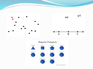
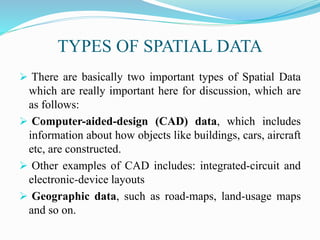
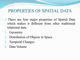
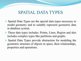
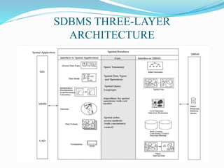
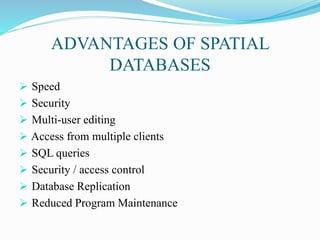
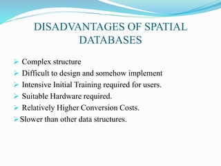
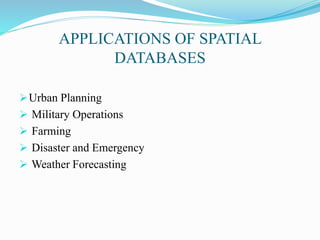
AMAN SINGLA (22-302)
&
KARTIK PATHAK (22-307)
TOPICS TO BE COVERED
 SPATIAL DATA
 TYPES OF SPATIAL DATA
 PROPERTIES OF SPATIAL DATA
 SPATIAL DATA TYPES
 SPATIAL DATABASE INTRODUCTION
 SPATIAL DATABASE CHARACTERISTICS
 SDBMS INTRODUCTION
 SDBMS THREE-LAYER ARCHITECTURE
TOPICS TO BE COVERED
 SPATIAL INDEX
 SPATIAL DATA CREATION
 ABOUT GIS
 ADVANTAGES OF SPATIAL DATABASES
 DISADVANTAGES OF SPATIAL DATABASES
 APPLICATIONS OF SPATIAL DATABASES
SPATIAL DATA
 Spatial Data means, data related to space or some pre-
defined location.
 Spatial Data includes shape, size, location and
orientation.
 These type of data are generally in the form of graphic
primitives which includes Points, Lines, P0lygons or
pixels.
 Spatial Data is comprised of objects in multi-
dimensional space.
TYPES OF SPATIAL DATA
 There are basically two important types of Spatial Data
which are really important here for discussion, which are
as follows:
 Computer-aided-design (CAD) data, which includes
information about how objects like buildings, cars, aircraft
etc, are constructed.
 Other examples of CAD includes: integrated-circuit and
electronic-device layouts
 Geographic data, such as road-maps, land-usage maps
and so on.
PROPERTIES OF SPATIAL DATA
 There are four major properties of Spatial Data
which makes it different from other traditional
relational data.
1. Geometry
2. Distribution of Objects in Space
3. Temporal Changes
4. Data Volume
SPATIAL DATA TYPES
 Spatial Data Types are the special data types necessary to
model geometry and to suitably represent geometric data
in database system.
 These data types includes: Points, Lines, Region and also
includes complex types like partitions and graphs.
 Spatial Data Types provide abstraction for modeling the
geometric structure of objects in space, their relationships,
properties and operations.
SPATIAL DATABASE INTRODUCTION
 Spatial Database is a full-fledged database system with additional
capabilities of handling spatial data.
 Spatial Database is used in order to analyze as well as manage
spatial data along with its high level utilization.
 Few examples of Spatial Database Users includes:
1. Transportation Agency Tracking Projects.
2. Doctor comparing Magnetic Resonance Images (MRI’s)
3. Mobile Phone Companies tracking phone usage
SPATIAL DATABASES
SPATIAL DATABASE CHARACTERISTICS
 Spatial Database stores objects that have spatial
characteristics that describe them.
 Spatial Database are designed in order to make the
storage, retrieval and manipulation of spatial data more
easier and more to users.
 Spatial Database provides concepts for databases that
actually keeps track of objects in multi-dimensional space.
SDBMS INTRODUCTION
 SDBMS stands for Spatial Database Management
System.
 SDBMS provides the capabilities of traditional database
management system in order to allow special storage and
handling of spatial data.
 SDBMS works with underlying DBMS and allows spatial
data models and types.
 SDBMS provides handling mechanisms of spatial data
and operations.
SDBMS THREE-LAYER
ARCHITECTURE
SPATIAL INDEX
Spatial indices are used by spatial databases (databases
which store information related to objects in space) in
order to optimize spatial queries.
Conventional index types do not efficiently handle
spatial queries such as how far two points differ, or
whether points fall within a spatial area of interest.
SPATIAL DATA CREATION
 Creation of an Entity named Country to hold data related
to country including name, state, population and
geographies.
create table Country (
name varchar(30),
state varchar(30),
population Integer,
shape Polygon
)
ABOUT GIS
 GIS stands for Geographic Information System.
GIS is used for the Management of Spatial Data
(Geographic Data and related applications).
GIS represents features of earth which includes: rivers,
roads, cities, buildings and states on a computer.
 We often use GIS in order to visualize, analyze, question
and understand data about the world as well as human
activity.
 This data is viewed over map which provides advantages
over using spreadsheet and database.
ADVANTAGES OF SPATIAL
DATABASES
 Speed
 Security
 Multi-user editing
 Access from multiple clients
 SQL queries
 Security / access control
 Database Replication
 Reduced Program Maintenance
DISADVANTAGES OF SPATIAL
DATABASES
 Complex structure
 Difficult to design and somehow implement
 Intensive Initial Training required for users.
 Suitable Hardware required.
 Relatively Higher Conversion Costs.
Slower than other data structures.
APPLICATIONS OF SPATIAL
DATABASES
Urban Planning
 Military Operations
 Farming
 Disaster and Emergency
 Weather Forecasting
REFERENCES
 Thirunavukkarasu K , Dr. Manoj Wadhwa; “Spatial Data
System: Architecture and Applications” International
Journal of Computer Science Trends and Technology
(IJCST) – Volume 4 Issue 5, Sep - Oct 2016
https://millermountain.com/geospatialblog/2017/10/18/spa
tial-database/
 https://en.wikipedia.org/wiki/Spatial_database
THANK YOU, HAVE A GOOD
DAY

SPATIAL DATABASES.pptx

  • 1.
  • 2.
    TOPICS TO BECOVERED  SPATIAL DATA  TYPES OF SPATIAL DATA  PROPERTIES OF SPATIAL DATA  SPATIAL DATA TYPES  SPATIAL DATABASE INTRODUCTION  SPATIAL DATABASE CHARACTERISTICS  SDBMS INTRODUCTION  SDBMS THREE-LAYER ARCHITECTURE
  • 3.
    TOPICS TO BECOVERED  SPATIAL INDEX  SPATIAL DATA CREATION  ABOUT GIS  ADVANTAGES OF SPATIAL DATABASES  DISADVANTAGES OF SPATIAL DATABASES  APPLICATIONS OF SPATIAL DATABASES
  • 4.
    SPATIAL DATA  SpatialData means, data related to space or some pre- defined location.  Spatial Data includes shape, size, location and orientation.  These type of data are generally in the form of graphic primitives which includes Points, Lines, P0lygons or pixels.  Spatial Data is comprised of objects in multi- dimensional space.
  • 6.
    TYPES OF SPATIALDATA  There are basically two important types of Spatial Data which are really important here for discussion, which are as follows:  Computer-aided-design (CAD) data, which includes information about how objects like buildings, cars, aircraft etc, are constructed.  Other examples of CAD includes: integrated-circuit and electronic-device layouts  Geographic data, such as road-maps, land-usage maps and so on.
  • 7.
    PROPERTIES OF SPATIALDATA  There are four major properties of Spatial Data which makes it different from other traditional relational data. 1. Geometry 2. Distribution of Objects in Space 3. Temporal Changes 4. Data Volume
  • 8.
    SPATIAL DATA TYPES Spatial Data Types are the special data types necessary to model geometry and to suitably represent geometric data in database system.  These data types includes: Points, Lines, Region and also includes complex types like partitions and graphs.  Spatial Data Types provide abstraction for modeling the geometric structure of objects in space, their relationships, properties and operations.
  • 9.
    SPATIAL DATABASE INTRODUCTION Spatial Database is a full-fledged database system with additional capabilities of handling spatial data.  Spatial Database is used in order to analyze as well as manage spatial data along with its high level utilization.  Few examples of Spatial Database Users includes: 1. Transportation Agency Tracking Projects. 2. Doctor comparing Magnetic Resonance Images (MRI’s) 3. Mobile Phone Companies tracking phone usage
  • 10.
  • 11.
    SPATIAL DATABASE CHARACTERISTICS Spatial Database stores objects that have spatial characteristics that describe them.  Spatial Database are designed in order to make the storage, retrieval and manipulation of spatial data more easier and more to users.  Spatial Database provides concepts for databases that actually keeps track of objects in multi-dimensional space.
  • 12.
    SDBMS INTRODUCTION  SDBMSstands for Spatial Database Management System.  SDBMS provides the capabilities of traditional database management system in order to allow special storage and handling of spatial data.  SDBMS works with underlying DBMS and allows spatial data models and types.  SDBMS provides handling mechanisms of spatial data and operations.
  • 13.
  • 14.
    SPATIAL INDEX Spatial indicesare used by spatial databases (databases which store information related to objects in space) in order to optimize spatial queries. Conventional index types do not efficiently handle spatial queries such as how far two points differ, or whether points fall within a spatial area of interest.
  • 15.
    SPATIAL DATA CREATION Creation of an Entity named Country to hold data related to country including name, state, population and geographies. create table Country ( name varchar(30), state varchar(30), population Integer, shape Polygon )
  • 16.
    ABOUT GIS  GISstands for Geographic Information System. GIS is used for the Management of Spatial Data (Geographic Data and related applications). GIS represents features of earth which includes: rivers, roads, cities, buildings and states on a computer.  We often use GIS in order to visualize, analyze, question and understand data about the world as well as human activity.  This data is viewed over map which provides advantages over using spreadsheet and database.
  • 17.
    ADVANTAGES OF SPATIAL DATABASES Speed  Security  Multi-user editing  Access from multiple clients  SQL queries  Security / access control  Database Replication  Reduced Program Maintenance
  • 18.
    DISADVANTAGES OF SPATIAL DATABASES Complex structure  Difficult to design and somehow implement  Intensive Initial Training required for users.  Suitable Hardware required.  Relatively Higher Conversion Costs. Slower than other data structures.
  • 19.
    APPLICATIONS OF SPATIAL DATABASES UrbanPlanning  Military Operations  Farming  Disaster and Emergency  Weather Forecasting
  • 20.
    REFERENCES  Thirunavukkarasu K, Dr. Manoj Wadhwa; “Spatial Data System: Architecture and Applications” International Journal of Computer Science Trends and Technology (IJCST) – Volume 4 Issue 5, Sep - Oct 2016 https://millermountain.com/geospatialblog/2017/10/18/spa tial-database/  https://en.wikipedia.org/wiki/Spatial_database
  • 21.
    THANK YOU, HAVEA GOOD DAY