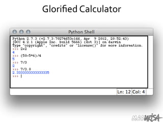
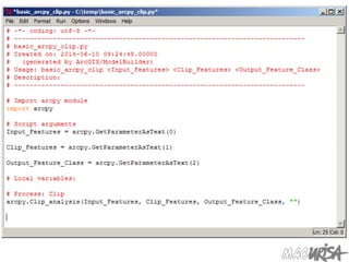
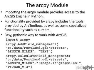
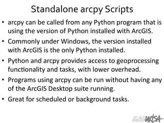
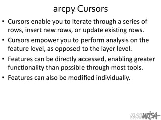
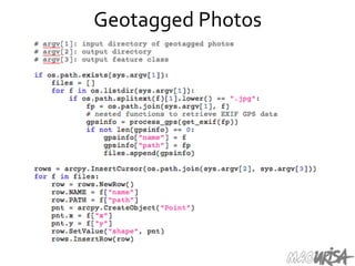
Downloaded 336 times


![Other
Python
Objects
• Lists
(mutable
sets
of
strings):
– var = [] # create list
– var = ['one', 2, 'three', 'banana']
• Tuples
(immutable
sets):
– var = ('one', 2, 'three', 'banana')
• Dic=onaries
(associa=ve
arrays
or
"hashes"):
– var = {} # create dictionary
– var = { 'lat': 40.20547,
'lon': -74.76322 }
– var['lat'] = 40.2054
• Each
has
its
own
set
of
methods.](https://image.slidesharecdn.com/pythonandgis-140612123744-phpapp01/85/Python-Programming-and-GIS-19-320.jpg)
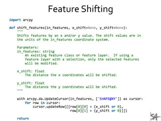
![Lists
• Think
of
a
list
as
a
stack
of
cards,
on
which
your
informa=on
is
wriIen.
• The
informa=on
stays
in
the
order
you
place
it
in
un=l
you
modify
that
order.
• Methods
return
a
string
or
subset
of
the
list
or
modify
the
list
to
add
or
remove
components.
• WriIen
as
var[index],
index
refers
to
order
within
set
(think
card
number,
star=ng
at
0).
• You
can
step
through
lists
as
part
of
a
loop.](https://image.slidesharecdn.com/pythonandgis-140612123744-phpapp01/85/Python-Programming-and-GIS-20-320.jpg)
![List
Methods
• Adding
to
the
List
– var[n] = object
• replaces
n
with
object
– var.append(object)
• adds
object
to
the
end
of
the
list
• Removing
from
the
List
– var[n] = []
• emp=es
contents
of
card,
but
preserves
order
– var.remove(n)
• removes
card
at
n
– var.pop(n)
• removes
n
and
returns
its
value](https://image.slidesharecdn.com/pythonandgis-140612123744-phpapp01/85/Python-Programming-and-GIS-21-320.jpg)
![List
Manipulation
• Using
array
slices,
you
can
iden=fy
a
subset
of
a
list
for
manipula=on
or
copying.
• a = [100, 101, 102]
• print a[1:]
• >>> [101, 102]
• Strings
act
as
lists
of
individual
characters,
so
array
slicing
can
be
used
for
string
subselec=on.](https://image.slidesharecdn.com/pythonandgis-140612123744-phpapp01/85/Python-Programming-and-GIS-23-320.jpg)
![Dictionaries
• Dic=onaries
are
sets
of
key
&
value
pairs.
• Allows
you
to
iden=fy
values
by
a
descrip=ve
name
instead
of
order
in
a
list.
• Keys
are
unordered
unless
explicitly
sorted.
• Keys
are
unique:
– var['item'] = "apple"
– var['item'] = "banana"
– print var['item'] prints
only
"banana"
– the
value
for
key
'item'
was
overwriIen](https://image.slidesharecdn.com/pythonandgis-140612123744-phpapp01/85/Python-Programming-and-GIS-25-320.jpg)
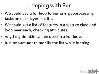
![Looping
with
For
• For
allows
you
to
loop
over
a
block
of
code
a
set
number
of
=mes
• For
is
great
for
manipula=ng
lists:
a = ['cat', 'window', 'defenestrate']
for x in a:
print x, len(x)
Results:
cat
3
window
6
defenestrate
12](https://image.slidesharecdn.com/pythonandgis-140612123744-phpapp01/85/Python-Programming-and-GIS-28-320.jpg)
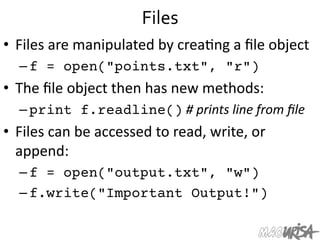
![Modules
• Modules
are
accessed
using
import
– import
sys,
os
#
imports
two
modules
• Modules
can
have
subsets
of
func=ons
– os.path
is
a
subset
within
os
• Modules
are
then
addressed
by
modulename.func=on()
– sys.argv
#
list
of
arguments
– filename
=
os.path.splitext("points.txt")
– filename[1]
#
equals
".txt"
• Documenta=on
on
modules
and
the
import
keyword
shows
the
power
of
modulariza=on.](https://image.slidesharecdn.com/pythonandgis-140612123744-phpapp01/85/Python-Programming-and-GIS-31-320.jpg)


The document outlines a workshop on Python programming for GIS, covering an introduction to Python's basics, its integration with ArcGIS, and the advantages of using Python in GIS workflows. It discusses various Python data structures, functionalities, and tools, including modules for geospatial processing and automation of tasks. Attendees are encouraged to explore learning resources and incorporate Python into their geospatial projects to enhance efficiency and capabilities.