This document is an assignment for a course on Planning History & Theory from Sarvajanik College of Engineering & Technology in Surat, India. It contains 12 questions on topics related to urban planning frameworks, thinkers, the evolution of planning after the industrial revolution, and definitions of key planning terms. The assignment asks students to explain concepts like the urban planning system in India according to URDPFI guidelines, the works of planners like Ebenezer Howard and Le Corbusier, and the effects of industrialization on urbanization and planning.
![SARVAJANIK EDUCATION SOCIETY
SARVAJANIK COLLEGE OF ENGINEERING &
TECHNOLOGY
R. K. Desai Marg, Athwalines
SURAT
P. G. CENTRE IN CIVIL ENGINEERING DEPARTMENT
MASTER OF ENGINEERING
(TOWN AND COUNTRY PLANNING)
[Branch Code - 048]
SUBJECT ASSIGNMENT
DECEMBER 2019
Planning History & Theory (3714801)](https://image.slidesharecdn.com/phtassignment-200820195629/85/Planning-History-Theory-Study-Notes-1-320.jpg)
![SARVAJANIK EDUCATION SOCIETY
SARVAJANIK COLLEGE OF ENGINEERING &
TECHNOLOGY
R. K. Desai Marg, Athwalines
SURAT
P. G. CENTRE IN CIVIL ENGINEERING DEPARTMENT
MASTER OF ENGINEERING
(TOWN AND COUNTRY PLANNING)
[Branch Code - 048]
SUBJECT ASSIGNMENT
DECEMBER 2019
Planning History & Theory (3714801)](https://image.slidesharecdn.com/phtassignment-200820195629/75/Planning-History-Theory-Study-Notes-1-2048.jpg)


![Planning History & Theory: Assignment
87 | P a g e
of individual settlements, self-contained in respect of schools and shopping and other
essential services and separated from each other by green spaces.
· The Maharashtra Regional and Town Planning Act was passed in 1966 and brought
into force in January 1967. The Bombay Metropolitan Region was notified in June 1967
and a Regional Planning Board constituted under the Chairmanship of Shri L.G.
Rajwade, I.C.S. The Draft Regional Plan of the Board was finalised in January 1970. It
proposed the development of a twin city across the harbour, on the mainland to the east,
as a counter-magnet to the office concentration taking place at the southern tip of
Bombay. The alternative growth pole was to siphon off the over concentration of jobs
and population which further growth would cause in the city and reallocate these on the
mainland. In making this recommendation, the Board was influenced by various factors
such as the existing industrial sites in the Thana-Belapur area and Taloja, the imminent
completion of the Thana Creek Bridge and the proposal of the Bombay Port Trust to
establish a new port at Nhava Sheva.
· The Board recommended that the new metro-centre or Navi Mumbai as it is now
called, be developed to accommodate a population of 2.1 million.
Implementation, development and issues
· The planning of Navi Mumbai could begin, in the right earnest, only by 1971, and
involved leading architects and urban planner like, Charles Correa (Chief Architect),
Shirish Patel, Pravina Mehta and R. K. Jha (Chief Planner), The City and Industrial
Development Corporation (CIDCO) was established on 17 March 1971, under the Indian
Companies Act, 1956 for this purpose. The area covered 150 kilometres (93 mi) of the
total 720 kilometres (450 mi) of the Konkan coast. Privately owned land consisting of 86
villages covering 15,954 hectares (39,420 acres) within the present limits of Navi
Mumbai and further villages measuring an additional 2,870 hectares (7,100 acres) were
acquired by the government of Maharashtra.[11]
The major part of Navi Mumbai covers
the southern part of Thane Taluka (from Thane District) and part of Panvel and Uran
taluka (from Raigad District).
· CIDCO carved out 14 small nodes with a view towards facilitating comprehensive
development. These nodes are named Airoli, Ghansoli, Kopar Khairane, Juhu Nagar,](https://image.slidesharecdn.com/phtassignment-200820195629/85/Planning-History-Theory-Study-Notes-87-320.jpg)
![Planning History & Theory: Assignment
91 | P a g e
·The Noida-Greater Noida Expressway is one of the prime development corridors in the
country and is unique as connectivity options are already functional or are making good
progress.
9) Short note NALCO Township, Angul, Orrisa
· Damanjodi is a town located in the Angul district of the Indian state of Odisha in the
Eastern Ghats. As of 2001, its population was 8,469. The town was founded as a residential
area for employees of the National Aluminium Company (NALCO), a company that was
established to harness the bauxite-rich deposits of the Panchpatmali Range. Damanjodi
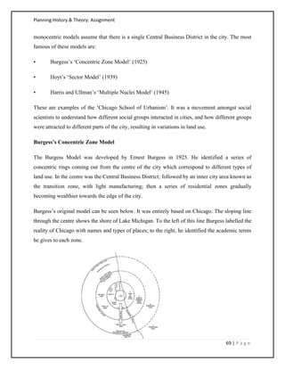
contains the NALCO Township, a residential area for employees of NALCO, Mathalput, a
semi-urban neighborhood with shops, and Bhejaput, a shopping complex. The population is
considered cosmopolitan in nature with employees from all over India and locals from the
tribal region.
Geography
· Damanjodi is located on the foothills of the Panchapatmali mountain range. The soil is
rich with bauxite and has a reddish appearance. The topography is mountainous, and the river
Kerandi runs nearby, serving as a source of clean water.
The local agrarian community produces rice, millets, vegetables, and mustard.
NALCO Township
· The NALCO township is composed of four sectors of housing quarters for the employees
of the firm. Facilities include a water supply and treatment plant, NALCO's captive power
plant, a hospital, banks with networked ATMs, three large co-operative stores, two market
complexes, clubs, community centers, temples, a church, and a mosque.
· The firm also has some housing in different locations around the township for employees
displaced from the main complex. The township also has stadiums, parks, avenues, walking
tracks, gardens, plantations, and waterfalls.
Demographics
· According to the 2001 Indian census,[1] Damanjodi has a population of 8,469. Males
constitute 54% of the population and females 46%. The average literacy rate was 83%,](https://image.slidesharecdn.com/phtassignment-200820195629/85/Planning-History-Theory-Study-Notes-91-320.jpg)