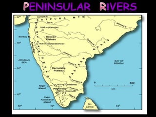
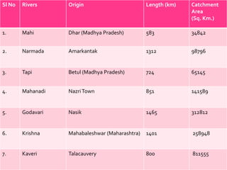
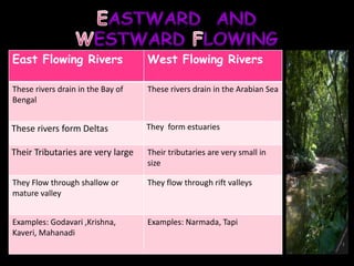
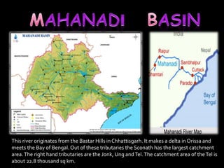
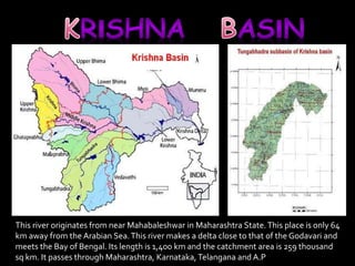
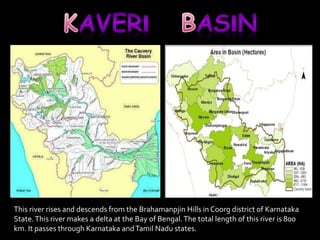
By: Varun
Sl No Rivers Origin Length (km) Catchment 
Area 
(Sq. Km.) 
1. Mahi Dhar (Madhya Pradesh) 583 34842 
2. Narmada Amarkantak 1312 98796 
3. Tapi Betul (Madhya Pradesh) 724 65145 
4. Mahanadi Nazri Town 851 141589 
5. Godavari Nasik 1465 312812 
6. Krishna Mahabaleshwar (Maharashtra) 1401 258948 
7. Kaveri Talacauvery 800 811555
East Flowing Rivers West Flowing Rivers 
These rivers drain in the Bay of 
Bengal 
These rivers drain in the Arabian Sea 
These rivers form Deltas They form estuaries 
Their Tributaries are very large Their tributaries are very small in 
size 
They Flow through shallow or 
mature valley 
They flow through rift valleys 
Examples: Godavari ,Krishna, 
Kaveri, Mahanadi 
Examples: Narmada, Tapi
The river rises from the Amarkantakapeak (1,057 m) of the Maikal Range in M.E It 
makes an estuary with Gulf of Khambat near Bharauch. Its length is 1,312 km and 
its catchment area is 93,000 sq km.
Sardar Sarovar Narmada Dam Dhuandhar falls 
Amarkantak Riverine Island Omkara
The Tapi or Tapti River is one of the main rivers of peninsular India. The river originates 
from the East Satpura Mountain Ranges, in south Madhya Pradesh. The river finishes 
its itinerary into the Gulf of Khambat, close to the Surat City in Gujarat.
Haripura 
^New 
Discovery 
of Upper 
Paleolithic 
Shelter Cave 
Painting in 
Tapti Valley in 
Central India 
< 
S 
U 
R 
A 
T 
Gulf of Khambhat
It originates in the Nasik district of Maharashtra State. It passes through Maharashtra and 
Andhra Pradesh and forms a delta in the Bay of Bengal. This river is 1,500 km long. Its 
drainage area is 312 thousand sq km.
Rajahmundry 
^The Godavari Bridge It is Asia's second longest 
road-cum-rail bridge crossing a water body 
Pochera and Kuntala Rajahmundry
This river originates from the Bastar Hills in Chhattisgarh. It makes a delta in Orissa and 
meets the Bay of Bengal. Out of these tributaries the Sconath has the largest catchment 
area. The right hand tributaries are the Jonk, Ung and Tel. The catchment area of the Tel is 
about 22.8 thousand sq km.
Hirakud dam 
Satkosia Tiger Resreve,Odisha 
Khandadhar Falls Jobra Barrage Bridge across the 
River Mahanadi
This river originates from near Mahabaleshwar in Maharashtra State. This place is only 64 
km away from the Arabian Sea. This river makes a delta close to that of the Godavari and 
meets the Bay of Bengal. Its length is 1,400 km and the catchment area is 259 thousand 
sq km. It passes through Maharashtra, Karnataka, Telangana and A.P
Srisailam Dam Dudhsagar Waterfalls 
Srivasta Nimmaraju Nagarjuna Sagar Dam
This river rises and descends from the Brahamanpjin Hills in Coorg district of Karnataka 
State. This river makes a delta at the Bay of Bengal. The total length of this river is 800 
km. It passes through Karnataka and Tamil Nadu states.
Talacauvery, the birth place of river Kaveri 
Cauvery water released to Tamil Nadu 
Chunchi falls 
Shivanasamudra
Peninsular River System

Peninsular River System

  • 1.
  • 3.
    Sl No RiversOrigin Length (km) Catchment Area (Sq. Km.) 1. Mahi Dhar (Madhya Pradesh) 583 34842 2. Narmada Amarkantak 1312 98796 3. Tapi Betul (Madhya Pradesh) 724 65145 4. Mahanadi Nazri Town 851 141589 5. Godavari Nasik 1465 312812 6. Krishna Mahabaleshwar (Maharashtra) 1401 258948 7. Kaveri Talacauvery 800 811555
  • 4.
    East Flowing RiversWest Flowing Rivers These rivers drain in the Bay of Bengal These rivers drain in the Arabian Sea These rivers form Deltas They form estuaries Their Tributaries are very large Their tributaries are very small in size They Flow through shallow or mature valley They flow through rift valleys Examples: Godavari ,Krishna, Kaveri, Mahanadi Examples: Narmada, Tapi
  • 5.
    The river risesfrom the Amarkantakapeak (1,057 m) of the Maikal Range in M.E It makes an estuary with Gulf of Khambat near Bharauch. Its length is 1,312 km and its catchment area is 93,000 sq km.
  • 6.
    Sardar Sarovar NarmadaDam Dhuandhar falls Amarkantak Riverine Island Omkara
  • 7.
    The Tapi orTapti River is one of the main rivers of peninsular India. The river originates from the East Satpura Mountain Ranges, in south Madhya Pradesh. The river finishes its itinerary into the Gulf of Khambat, close to the Surat City in Gujarat.
  • 8.
    Haripura ^New Discovery of Upper Paleolithic Shelter Cave Painting in Tapti Valley in Central India < S U R A T Gulf of Khambhat
  • 9.
    It originates inthe Nasik district of Maharashtra State. It passes through Maharashtra and Andhra Pradesh and forms a delta in the Bay of Bengal. This river is 1,500 km long. Its drainage area is 312 thousand sq km.
  • 10.
    Rajahmundry ^The GodavariBridge It is Asia's second longest road-cum-rail bridge crossing a water body Pochera and Kuntala Rajahmundry
  • 11.
    This river originatesfrom the Bastar Hills in Chhattisgarh. It makes a delta in Orissa and meets the Bay of Bengal. Out of these tributaries the Sconath has the largest catchment area. The right hand tributaries are the Jonk, Ung and Tel. The catchment area of the Tel is about 22.8 thousand sq km.
  • 12.
    Hirakud dam SatkosiaTiger Resreve,Odisha Khandadhar Falls Jobra Barrage Bridge across the River Mahanadi
  • 13.
    This river originatesfrom near Mahabaleshwar in Maharashtra State. This place is only 64 km away from the Arabian Sea. This river makes a delta close to that of the Godavari and meets the Bay of Bengal. Its length is 1,400 km and the catchment area is 259 thousand sq km. It passes through Maharashtra, Karnataka, Telangana and A.P
  • 14.
    Srisailam Dam DudhsagarWaterfalls Srivasta Nimmaraju Nagarjuna Sagar Dam
  • 15.
    This river risesand descends from the Brahamanpjin Hills in Coorg district of Karnataka State. This river makes a delta at the Bay of Bengal. The total length of this river is 800 km. It passes through Karnataka and Tamil Nadu states.
  • 16.
    Talacauvery, the birthplace of river Kaveri Cauvery water released to Tamil Nadu Chunchi falls Shivanasamudra