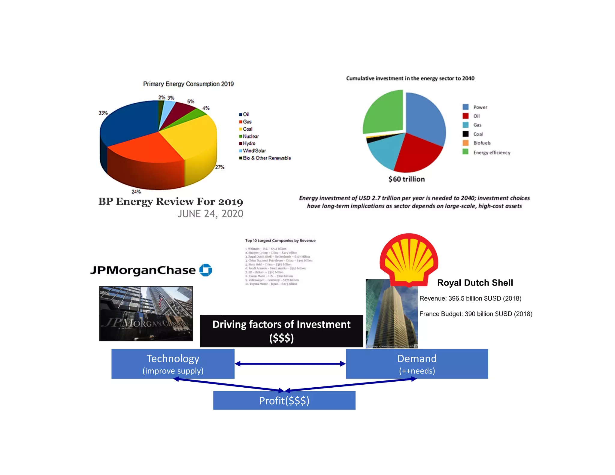
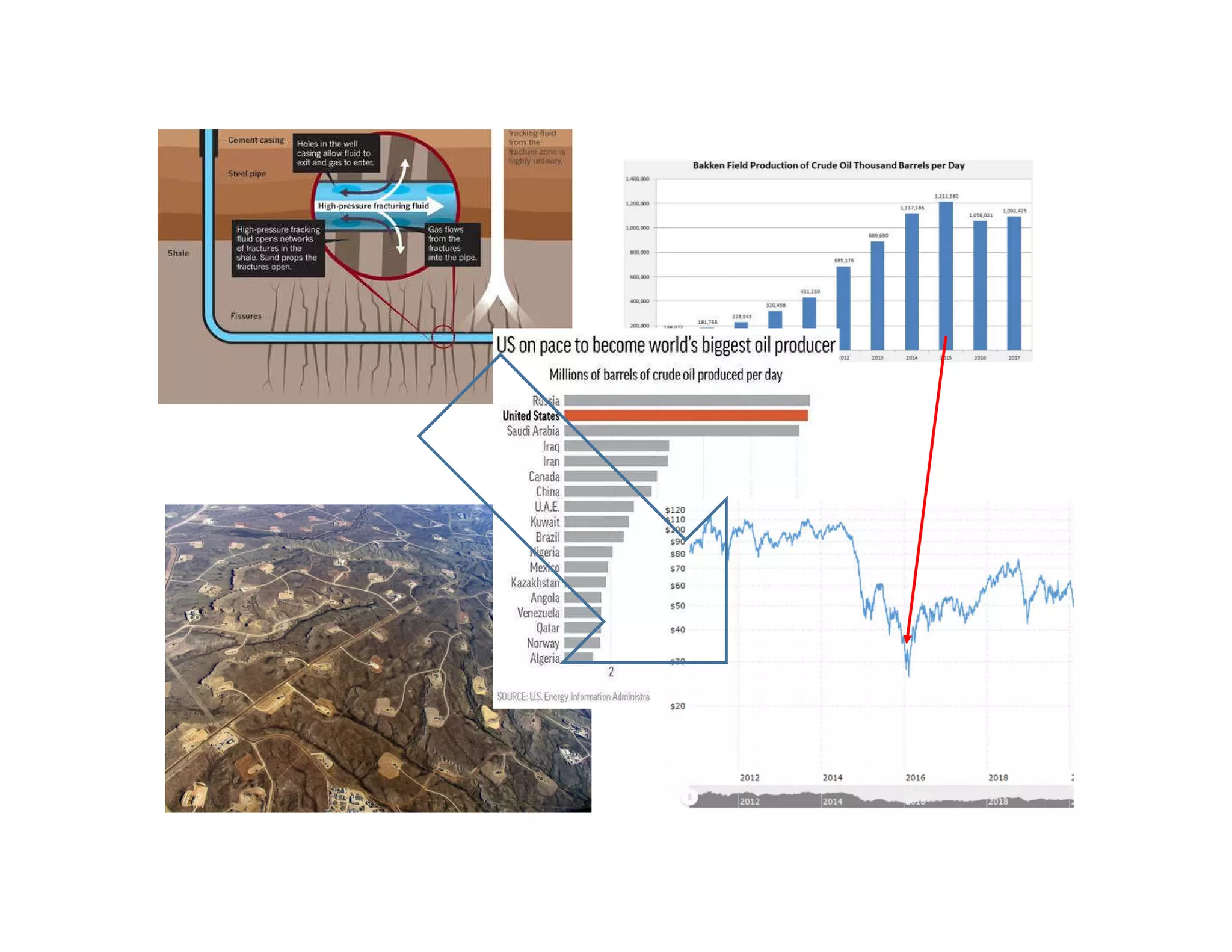
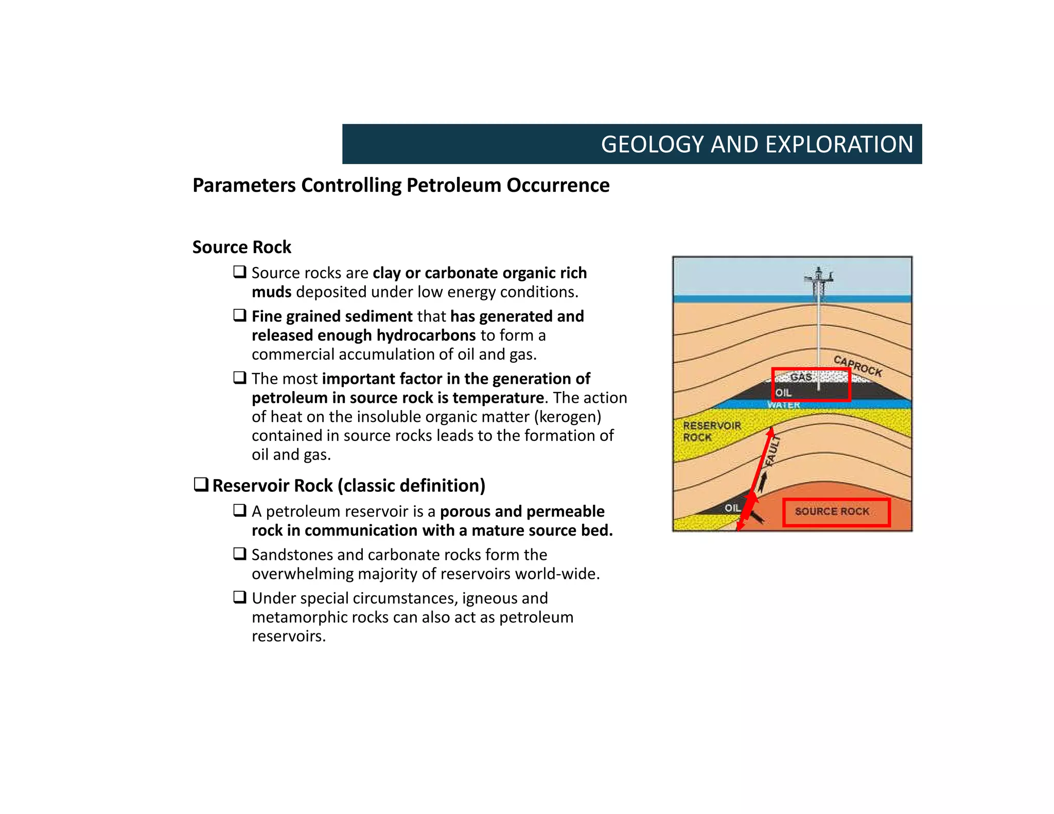
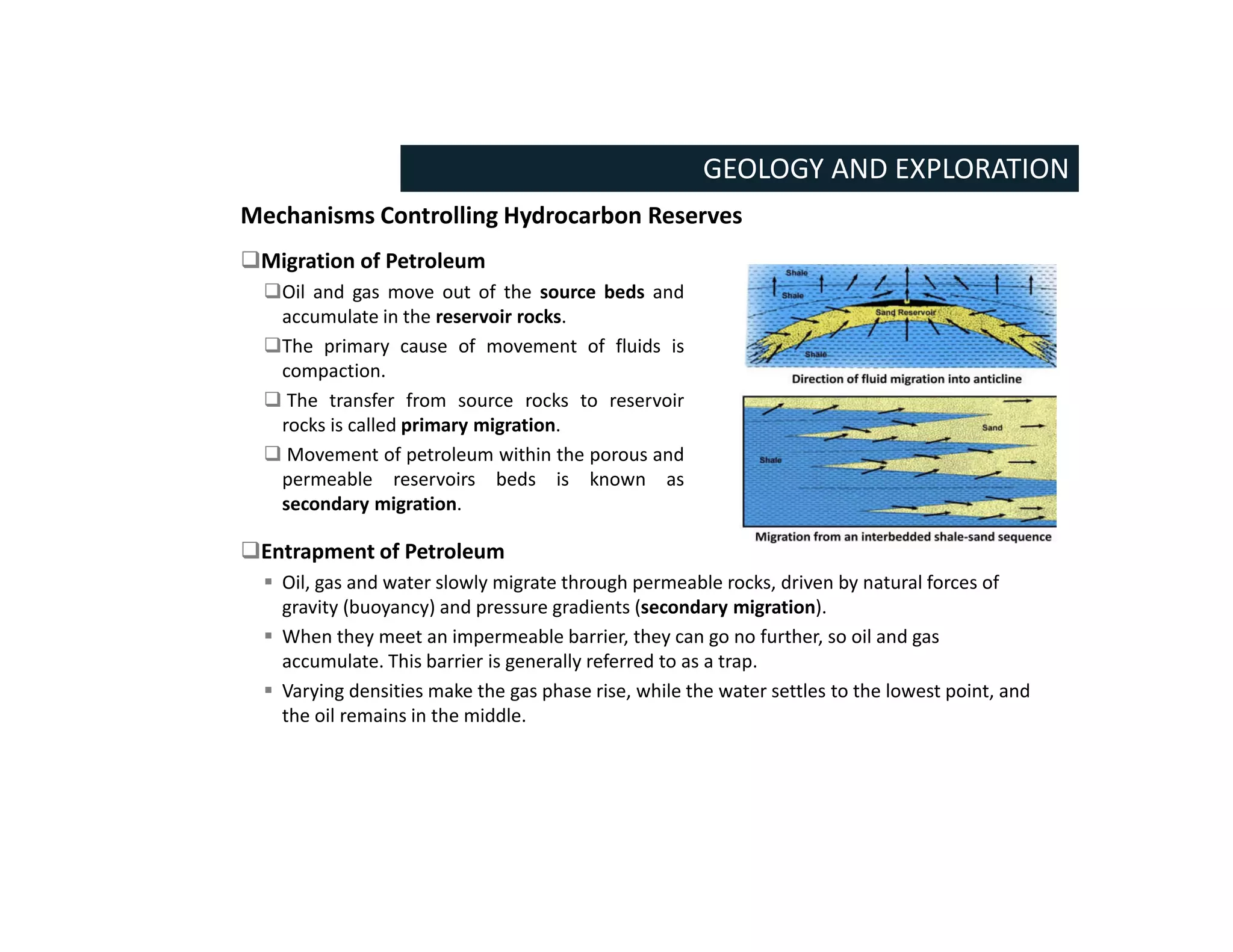
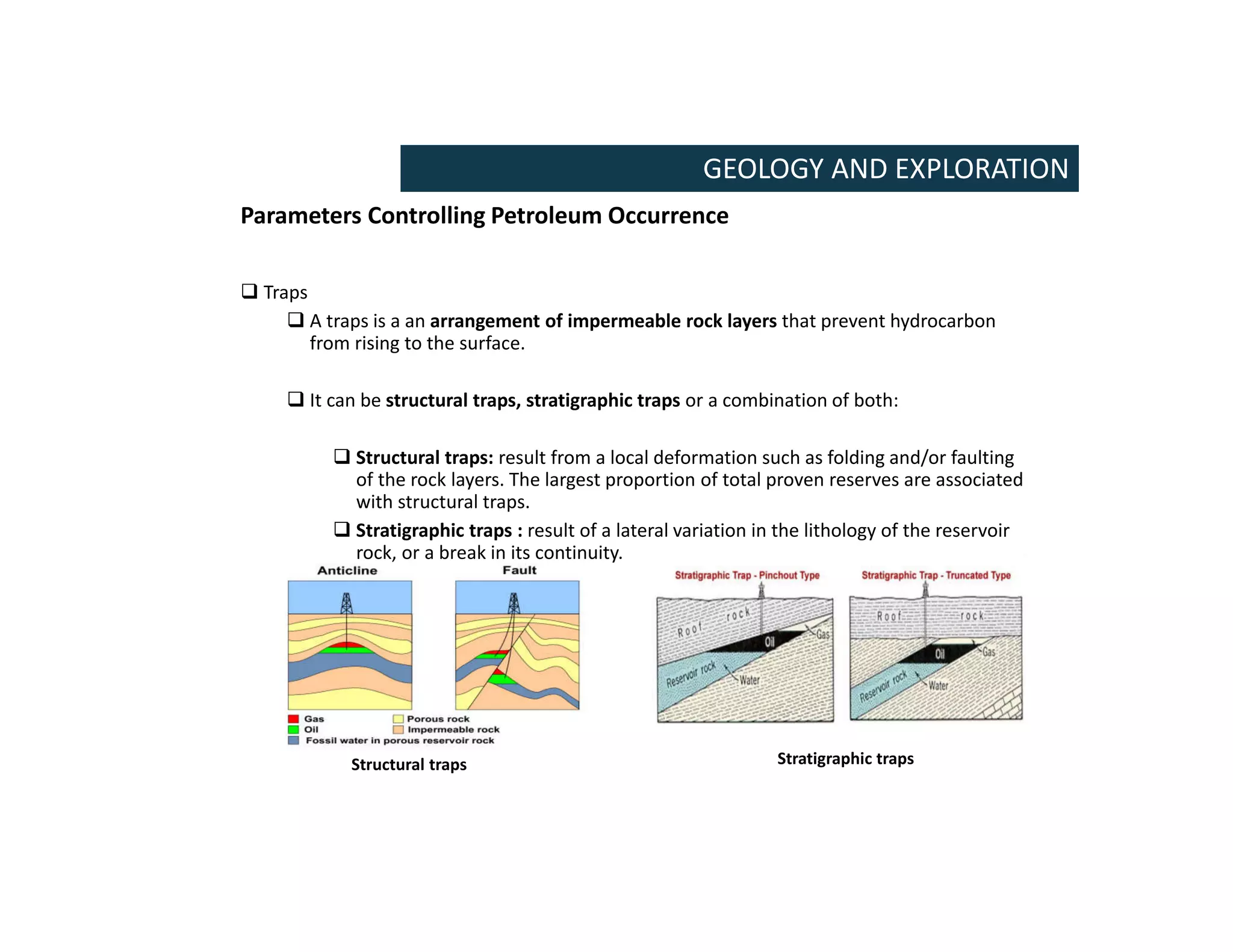
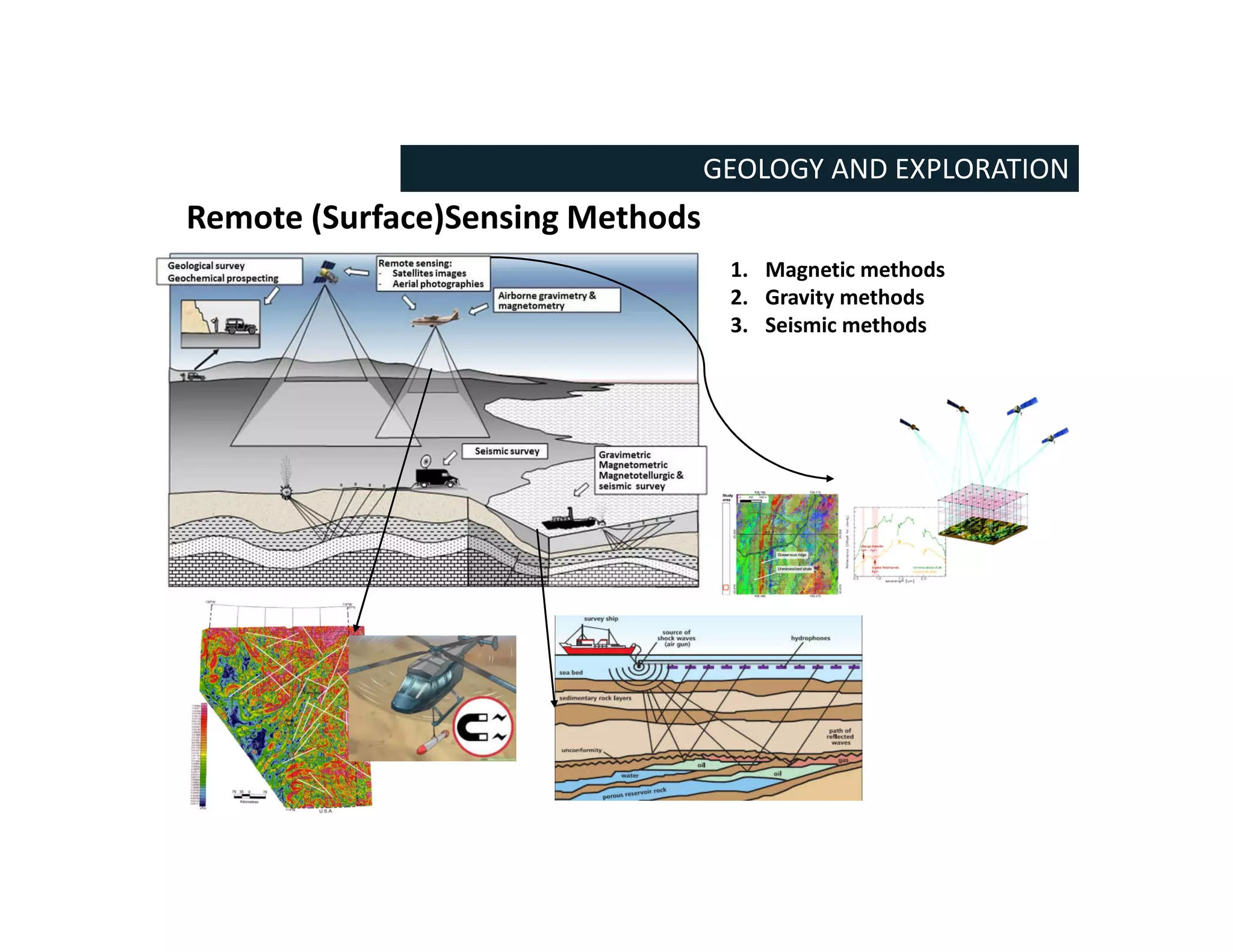
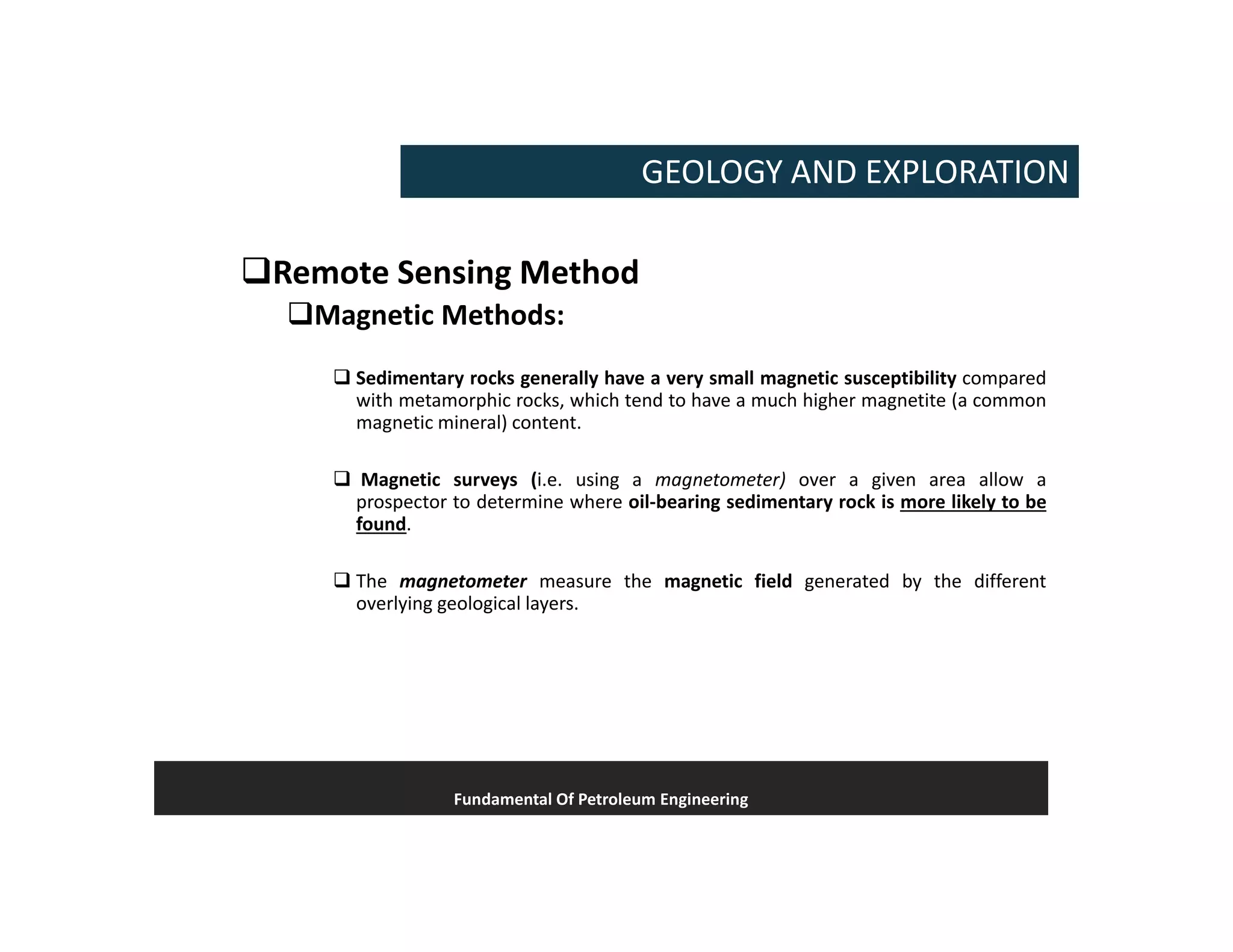
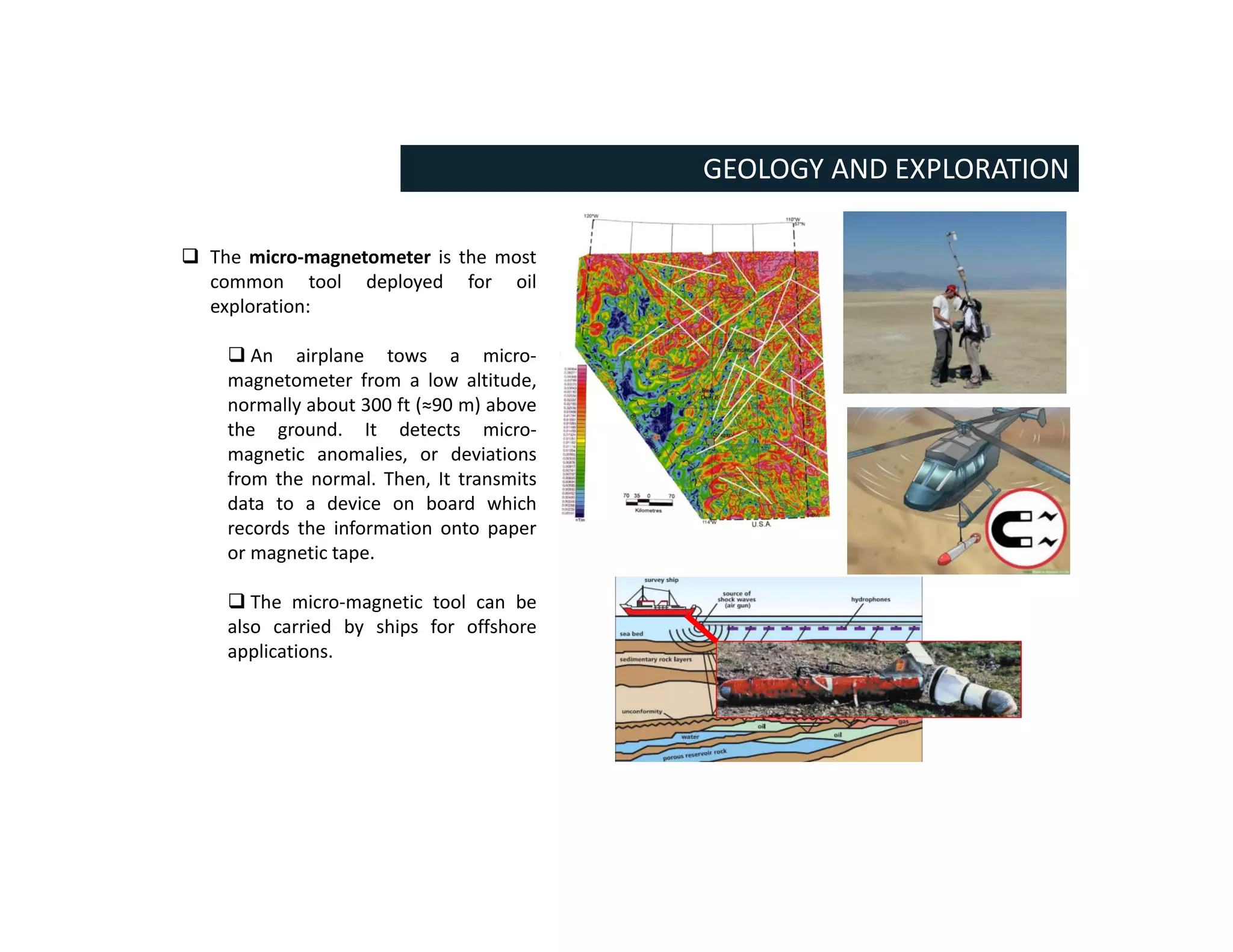
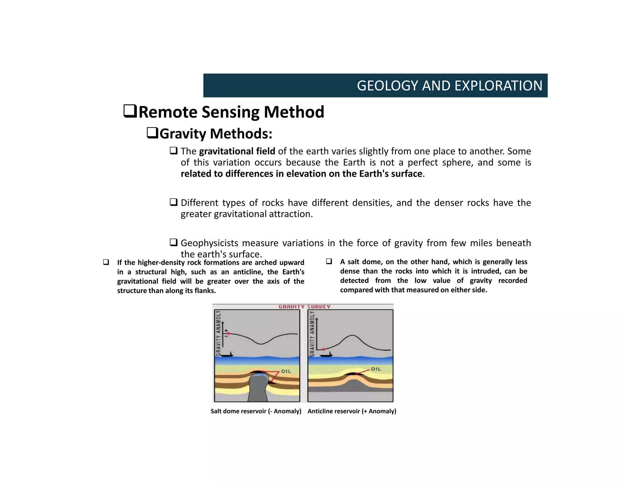
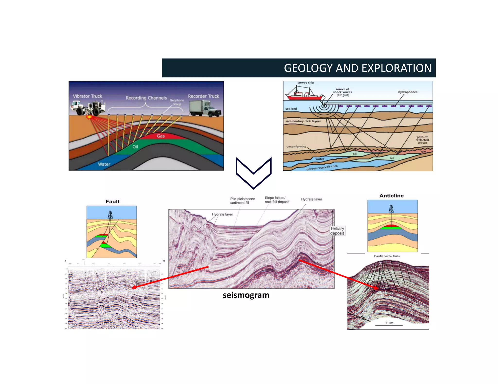
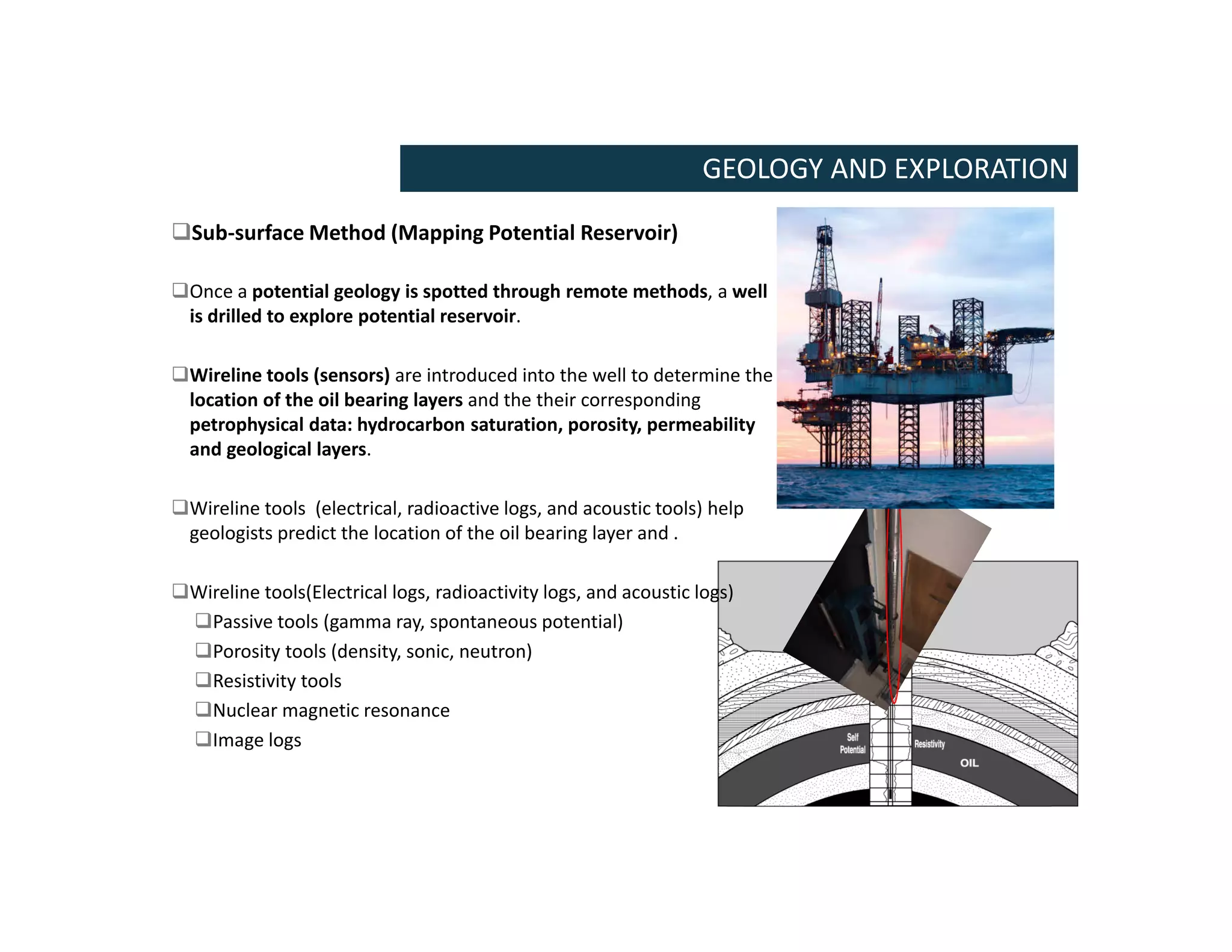
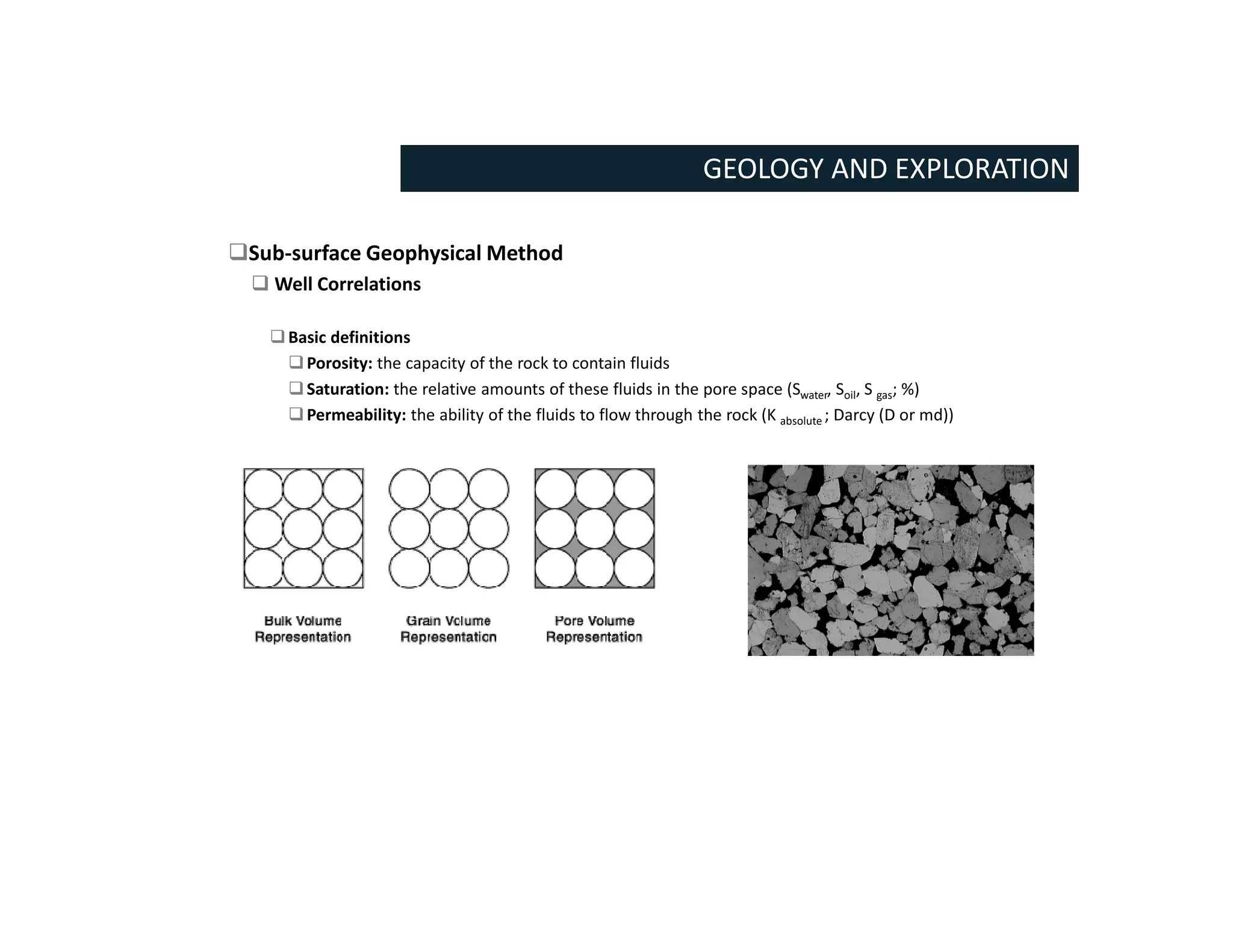
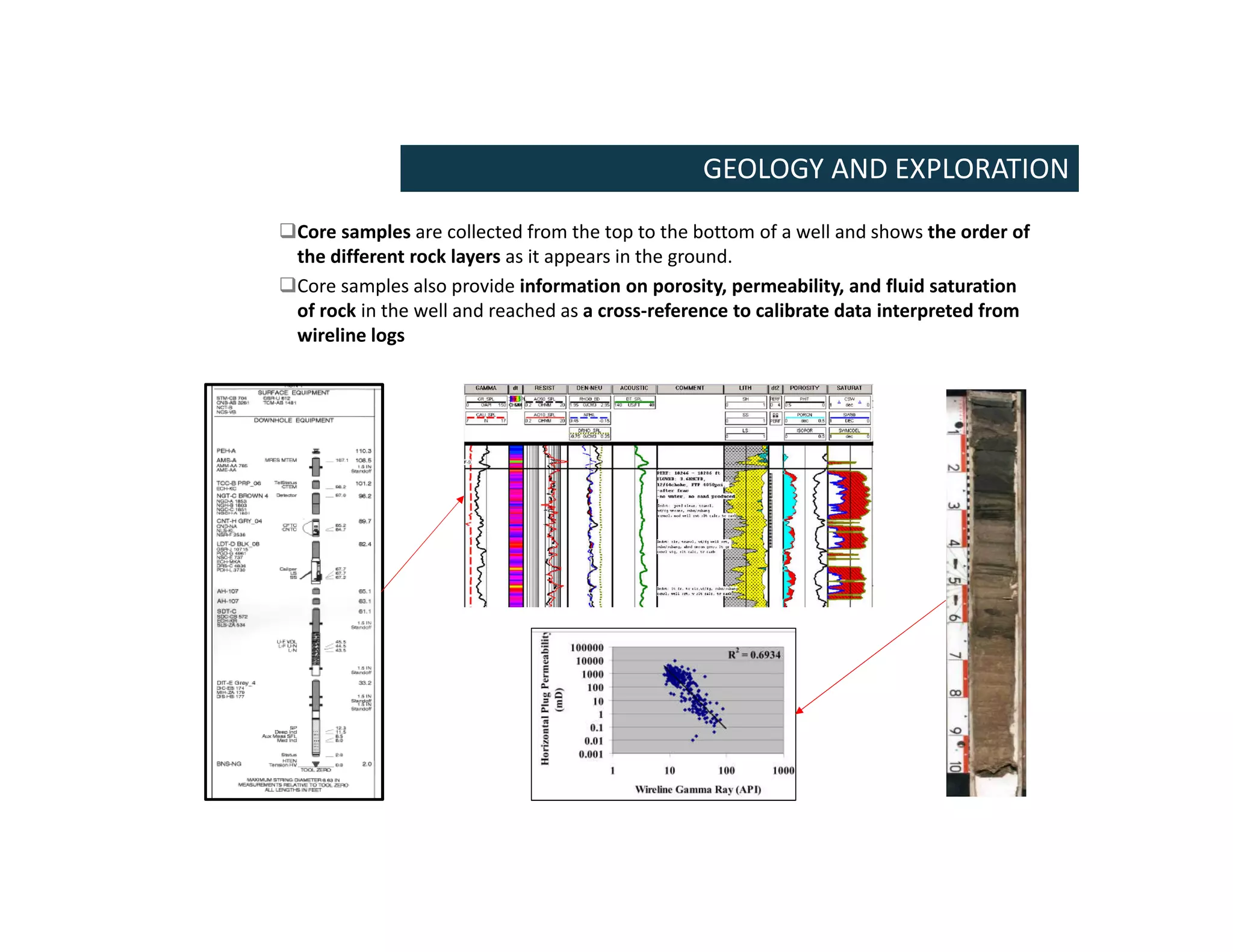
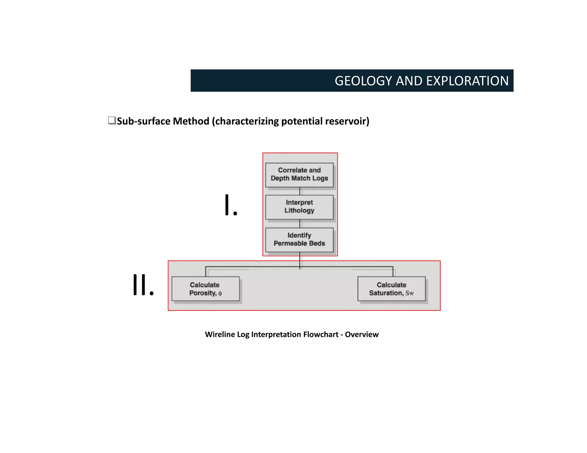
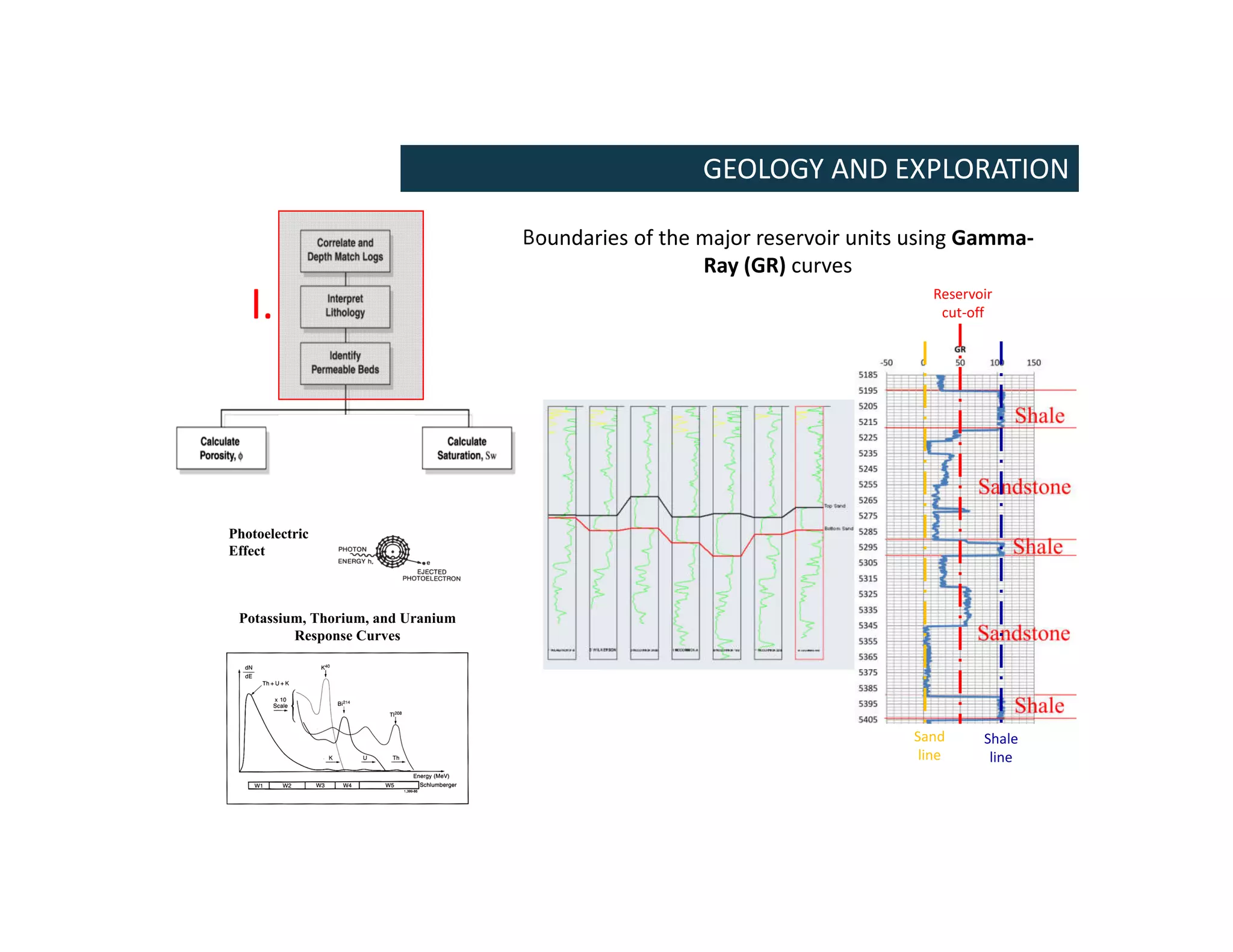
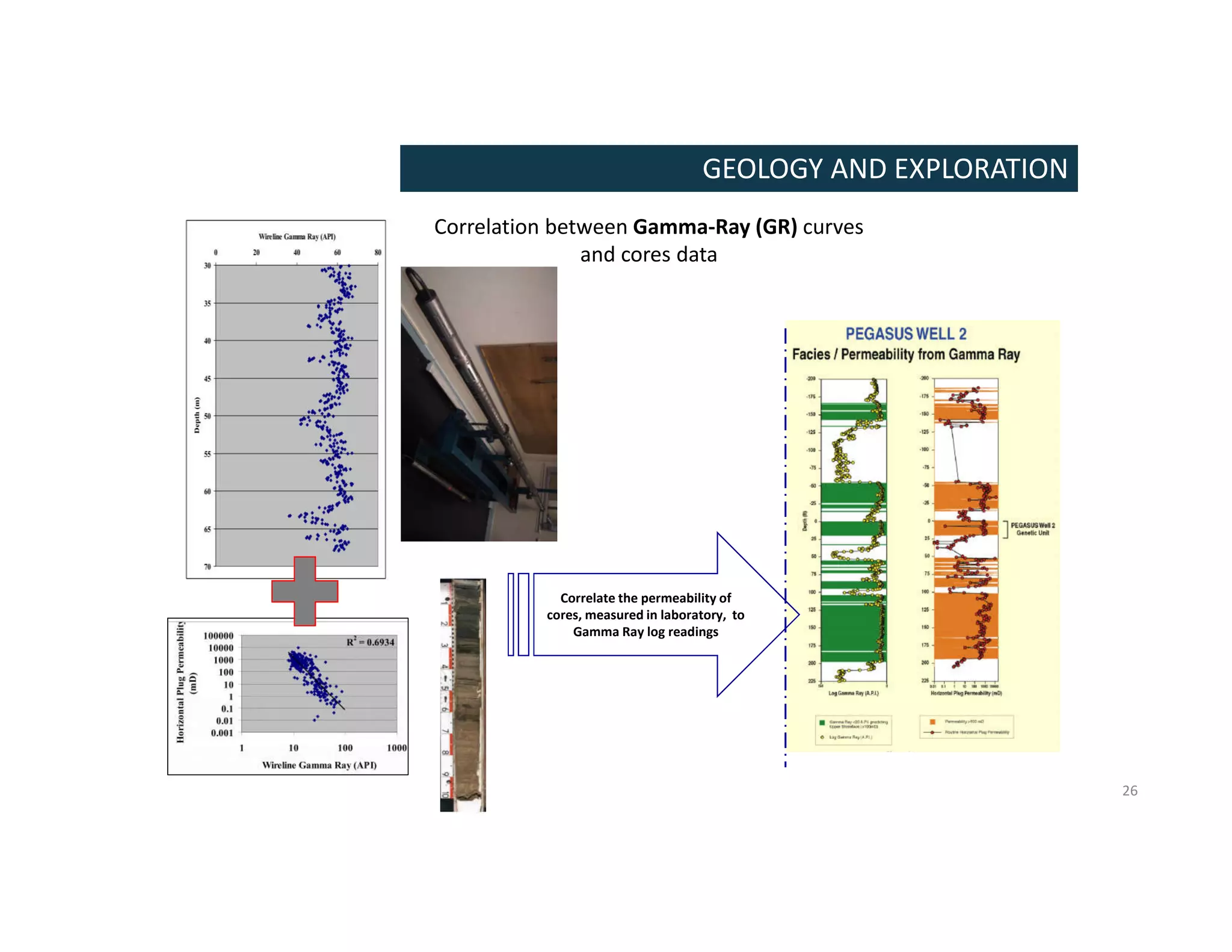
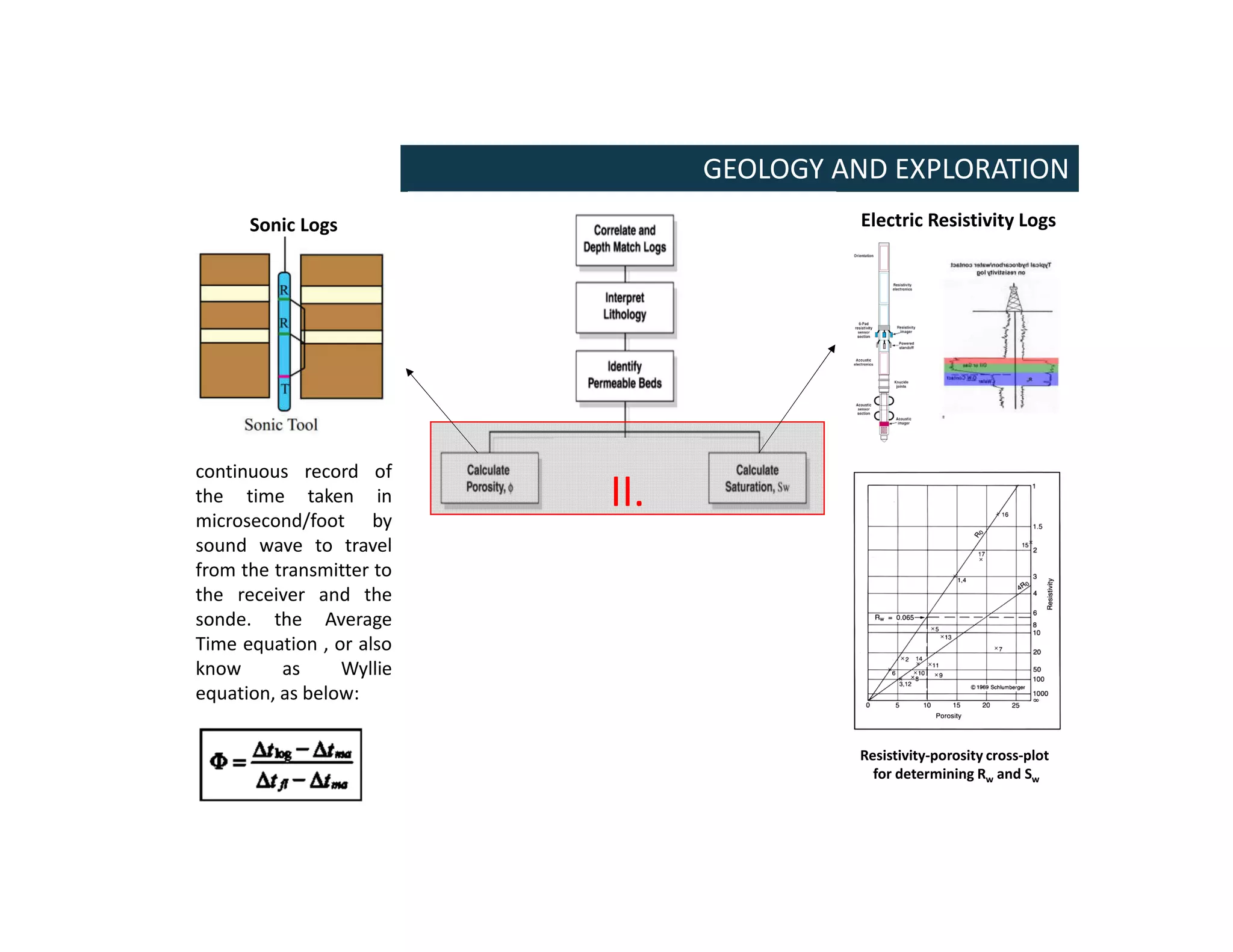
ENERGY INDUSTRY:
FINANCIAL AND TECHNICAL CONCEPTS
Kais Ben Abdallah, M.Sc., P.Eng, Ph.D. candidate.
ESPRIT
Department of Civil Engineering
Nov. 2020
PRESENTATION CONTENTS
Energy sector:
 Driving key of investments: renewable energy or hydrocarbon resources?
 What make price of oil and gas drop or rise?
Petroleum Engineering: basic concepts
 What is Petroleum Engineering?
 What Does Petroleum Mean?
 Generation of Petroleum
 Geology and exploration
BP Energy Review For 2019
JUNE 24, 2020
Technology
(improve supply)
Demand
(++needs)
Driving factors of Investment
($$$)
Driving factors of Investment
($$$)
Profit($$$)
Royal Dutch Shell
Revenue: 396.5 billion $USD (2018)
France Budget: 390 billion $USD (2018)
What is Petroleum Engineering?
An engineering discipline concerned with the activities related to the production of
hydrocarbons, crude oil or natural gas.
Petroleum engineers are divided into several groups:
PETROLEUM ENGINEERING
 Petroleum geologists find hydrocarbons by analysing subsurface
structures with geological and geophysical methods.
 Reservoir engineers work to optimize production of oil and gas
via proper well placement, production levels, and enhanced oil
recovery techniques
 Drilling engineers manage the technical aspects of drilling
exploratory, production and injection wells. It also include mud
engineer who manage the quality of drilling fluid.
 Production engineers, including subsurface engineers, manage
the interface between the reservoir and the well, including
perforations, sand control, downhole flow control, and downhole
monitoring equipment; evaluate artificial lift methods; and also
select surface equipment that separates the produced fluids (oil,
gas, and water).
What is Petroleum Engineering?
PETROLEUM ENGINEERING
https://www.youtube.com/watch?time_continue=41&v=WH9D7aqOp0Q
What Does Petroleum Mean?
Petroleum literally means ‘rock oil’. The word comes from the Greek word ‘petra’
(meaning ‘rock’) and the Latin word ‘oleum’ (meaning ‘oil’).
Petroleum or crude oil is a naturally occurring flammable liquid
consisting of a complex mixture of hydrocarbons of various
molecular weights, and other organic compounds, that are found
in geologic formations beneath the Earth's surface.
When it comes out of a well, the crude oil is often mixed with
gases, water and sand.
Petroleum is recovered mostly through oil drilling. It is refined
and separated, most easily by boiling point, into a large number of
consumer products, from gasoline and kerosene to asphalt and
chemicals used to make plastics and pharmaceutical products.
PETROLEUM DEFINITION
Production Process of Hydrocarbons
The production process of hydrocarbons is commonly divided into Upstream and
Downstream parts:
PRODUCTION PROCESS OF HYDROCARBONS
 The Downstream stage in the
production process involves processing
the materials collected during the
upstream stage into a finished product.
In the oil and gas industry, the
downstream process consists of
converting crude oil into other products
and then selling those products to
customers. Oil refineries represent
main structures that operate within the
downstream process.
 The Upstream stage of the production process
involves searching for and extracting raw
materials. In the petroleum industry; locating
underground oil reserves (Petroleum geologists,
Reservoir engineers ) access to theses reserves
(Drilling engineers), and bringing oil and gas to
the surface (Production Engineers)
characterizes the upstream process.
Parameters Controlling Petroleum Occurrence
Source Rock
 Source rocks are clay or carbonate organic rich
muds deposited under low energy conditions.
 Fine grained sediment that has generated and
released enough hydrocarbons to form a
commercial accumulation of oil and gas.
 The most important factor in the generation of
petroleum in source rock is temperature. The action
of heat on the insoluble organic matter (kerogen)
contained in source rocks leads to the formation of
oil and gas.
Reservoir Rock (classic definition)
 A petroleum reservoir is a porous and permeable
rock in communication with a mature source bed.
 Sandstones and carbonate rocks form the
overwhelming majority of reservoirs world-wide.
 Under special circumstances, igneous and
metamorphic rocks can also act as petroleum
reservoirs.
GEOLOGY AND EXPLORATION
Mechanisms Controlling Hydrocarbon Reserves
GEOLOGY AND EXPLORATION
Migration of Petroleum
Oil and gas move out of the source beds and
accumulate in the reservoir rocks.
The primary cause of movement of fluids is
compaction.
 The transfer from source rocks to reservoir
rocks is called primary migration.
 Movement of petroleum within the porous and
permeable reservoirs beds is known as
secondary migration.
Entrapment of Petroleum
 Oil, gas and water slowly migrate through permeable rocks, driven by natural forces of
gravity (buoyancy) and pressure gradients (secondary migration).
 When they meet an impermeable barrier, they can go no further, so oil and gas
accumulate. This barrier is generally referred to as a trap.
 Varying densities make the gas phase rise, while the water settles to the lowest point, and
the oil remains in the middle.
Parameters Controlling Petroleum Occurrence
 Traps
 A traps is a an arrangement of impermeable rock layers that prevent hydrocarbon
from rising to the surface.
 It can be structural traps, stratigraphic traps or a combination of both:
 Structural traps: result from a local deformation such as folding and/or faulting
of the rock layers. The largest proportion of total proven reserves are associated
with structural traps.
 Stratigraphic traps : result of a lateral variation in the lithology of the reservoir
rock, or a break in its continuity.
GEOLOGY AND EXPLORATION
Structural traps Stratigraphic traps
Geological cross-section: Ordovician formations.
explain how producing oil/gas in Tunisia is way more expensive than producing
from Libyan/Algerian reserves?
Oil Exploration Method (Mapping Potential Reservoir)
GEOLOGY AND EXPLORATION
The selection of an effective exploration method is an important step to achieve success in oil
exploration. Several methods are present in natural resource discovery and can be grouped as
Surface and Sub-surface Methods.
Surface Methods: geological assessment
 Surface (Remote) Sensing Method
 Remote sensing refers to using infrared or other remote means to map an area.
 This method is used to study the basic of petroleum geological conditions.
 provide accurate visual data for directly determining geometric shapes of sedimentary
basins.
 Companies are using remote sensing data as an initial exploration approach, however,
still need sub-surface exploration information to pinpoint the location of commercial
deposits.
Remote (Surface)Sensing Methods
GEOLOGY AND EXPLORATION
1. Magnetic methods
2. Gravity methods
3. Seismic methods
Remote Sensing Method
Magnetic Methods:
 Sedimentary rocks generally have a very small magnetic susceptibility compared
with metamorphic rocks, which tend to have a much higher magnetite (a common
magnetic mineral) content.
 Magnetic surveys (i.e. using a magnetometer) over a given area allow a
prospector to determine where oil-bearing sedimentary rock is more likely to be
found.
 The magnetometer measure the magnetic field generated by the different
overlying geological layers.
Fundamental Of Petroleum Engineering
GEOLOGY AND EXPLORATION
 The micro-magnetometer is the most
common tool deployed for oil
exploration:
 An airplane tows a micro-
magnetometer from a low altitude,
normally about 300 ft (≈90 m) above
the ground. It detects micro-
magnetic anomalies, or deviations
from the normal. Then, It transmits
data to a device on board which
records the information onto paper
or magnetic tape.
 The micro-magnetic tool can be
also carried by ships for offshore
applications.
Remote Sensing Method
Gravity Methods:
 The gravitational field of the earth varies slightly from one place to another. Some
of this variation occurs because the Earth is not a perfect sphere, and some is
related to differences in elevation on the Earth's surface.
 Different types of rocks have different densities, and the denser rocks have the
greater gravitational attraction.
 Geophysicists measure variations in the force of gravity from few miles beneath
the earth's surface.
GEOLOGY AND EXPLORATION
 If the higher-density rock formations are arched upward
in a structural high, such as an anticline, the Earth's
gravitational field will be greater over the axis of the
structure than along its flanks.
 A salt dome, on the other hand, which is generally less
dense than the rocks into which it is intruded, can be
detected from the low value of gravity recorded
compared with that measured on either side.
Anticline reservoir (+ Anomaly)
Salt dome reservoir (- Anomaly)
Remote Sensing Method
Seismic Methods:
 Seismic reflection, a powerful technique for underground exploration, has been used
for over 60 years. It will give more precise details on the formations beneath the
surface.
 Seismic waves are essentially sound waves that travel underground at velocities of 2 to
4 miles per second (3 to 6 km per second), depending upon the type of rock through
which they pass.
 The reflections of Seismic waves are recorded using geophones, instruments that allow
detection of ground motion. Geophones are laid along the ground at variable distances
from the shot. From the geophones, the wave will be send through cables to a recorder.
The recorder, a seismograph, amplifies and records the wave characteristics to produce
a seismogram.
 Variations in the reflection times from place to place on the surface usually indicate
structural features in the strata below.
 The information from a seismic survey (seismogram) indicates the types of rock, their
elative depth, and whether a trap is present.
GEOLOGY AND EXPLORATION
seismogram
GEOLOGY AND EXPLORATION
Sub-surface Method (Mapping Potential Reservoir)
Once a potential geology is spotted through remote methods, a well
is drilled to explore potential reservoir.
Wireline tools (sensors) are introduced into the well to determine the
location of the oil bearing layers and the their corresponding
petrophysical data: hydrocarbon saturation, porosity, permeability
and geological layers.
Wireline tools (electrical, radioactive logs, and acoustic tools) help
geologists predict the location of the oil bearing layer and .
Wireline tools(Electrical logs, radioactivity logs, and acoustic logs)
Passive tools (gamma ray, spontaneous potential)
Porosity tools (density, sonic, neutron)
Resistivity tools
Nuclear magnetic resonance
Image logs
GEOLOGY AND EXPLORATION
Sub-surface Geophysical Method
 Well Correlations
Basic definitions
Porosity: the capacity of the rock to contain fluids
Saturation: the relative amounts of these fluids in the pore space (Swater, Soil, S gas; %)
Permeability: the ability of the fluids to flow through the rock (K absolute ; Darcy (D or md))
GEOLOGY AND EXPLORATION
Core samples are collected from the top to the bottom of a well and shows the order of
the different rock layers as it appears in the ground.
Core samples also provide information on porosity, permeability, and fluid saturation
of rock in the well and reached as a cross-reference to calibrate data interpreted from
wireline logs
GEOLOGY AND EXPLORATION
Sub-surface Method (characterizing potential reservoir)
Wireline Log Interpretation Flowchart - Overview
I.
II.
GEOLOGY AND EXPLORATION
Boundaries of the major reservoir units using Gamma-
Ray (GR) curves
Sand
line
Reservoir
cut-off
Shale
line
I.
Correlate the permeability of
cores, measured in laboratory, to
Gamma Ray log readings
26
Correlation between Gamma-Ray (GR) curves
and cores data
GEOLOGY AND EXPLORATION
Sonic Logs
continuous record of
the time taken in
microsecond/foot by
sound wave to travel
from the transmitter to
the receiver and the
sonde. the Average
Time equation , or also
know as Wyllie
equation, as below:
Electric Resistivity Logs
Resistivity-porosity cross-plot
for determining Rw and Sw
II.

Lecture I Introduction to Oil&Gas (Reservoir Engineering).pdf

  • 1.
    ENERGY INDUSTRY: FINANCIAL ANDTECHNICAL CONCEPTS Kais Ben Abdallah, M.Sc., P.Eng, Ph.D. candidate. ESPRIT Department of Civil Engineering Nov. 2020
  • 2.
    PRESENTATION CONTENTS Energy sector: Driving key of investments: renewable energy or hydrocarbon resources?  What make price of oil and gas drop or rise? Petroleum Engineering: basic concepts  What is Petroleum Engineering?  What Does Petroleum Mean?  Generation of Petroleum  Geology and exploration
  • 3.
    BP Energy ReviewFor 2019 JUNE 24, 2020 Technology (improve supply) Demand (++needs) Driving factors of Investment ($$$) Driving factors of Investment ($$$) Profit($$$) Royal Dutch Shell Revenue: 396.5 billion $USD (2018) France Budget: 390 billion $USD (2018)
  • 5.
    What is PetroleumEngineering? An engineering discipline concerned with the activities related to the production of hydrocarbons, crude oil or natural gas. Petroleum engineers are divided into several groups: PETROLEUM ENGINEERING  Petroleum geologists find hydrocarbons by analysing subsurface structures with geological and geophysical methods.  Reservoir engineers work to optimize production of oil and gas via proper well placement, production levels, and enhanced oil recovery techniques  Drilling engineers manage the technical aspects of drilling exploratory, production and injection wells. It also include mud engineer who manage the quality of drilling fluid.  Production engineers, including subsurface engineers, manage the interface between the reservoir and the well, including perforations, sand control, downhole flow control, and downhole monitoring equipment; evaluate artificial lift methods; and also select surface equipment that separates the produced fluids (oil, gas, and water).
  • 6.
    What is PetroleumEngineering? PETROLEUM ENGINEERING https://www.youtube.com/watch?time_continue=41&v=WH9D7aqOp0Q
  • 7.
    What Does PetroleumMean? Petroleum literally means ‘rock oil’. The word comes from the Greek word ‘petra’ (meaning ‘rock’) and the Latin word ‘oleum’ (meaning ‘oil’). Petroleum or crude oil is a naturally occurring flammable liquid consisting of a complex mixture of hydrocarbons of various molecular weights, and other organic compounds, that are found in geologic formations beneath the Earth's surface. When it comes out of a well, the crude oil is often mixed with gases, water and sand. Petroleum is recovered mostly through oil drilling. It is refined and separated, most easily by boiling point, into a large number of consumer products, from gasoline and kerosene to asphalt and chemicals used to make plastics and pharmaceutical products. PETROLEUM DEFINITION
  • 8.
    Production Process ofHydrocarbons The production process of hydrocarbons is commonly divided into Upstream and Downstream parts: PRODUCTION PROCESS OF HYDROCARBONS  The Downstream stage in the production process involves processing the materials collected during the upstream stage into a finished product. In the oil and gas industry, the downstream process consists of converting crude oil into other products and then selling those products to customers. Oil refineries represent main structures that operate within the downstream process.  The Upstream stage of the production process involves searching for and extracting raw materials. In the petroleum industry; locating underground oil reserves (Petroleum geologists, Reservoir engineers ) access to theses reserves (Drilling engineers), and bringing oil and gas to the surface (Production Engineers) characterizes the upstream process.
  • 9.
    Parameters Controlling PetroleumOccurrence Source Rock  Source rocks are clay or carbonate organic rich muds deposited under low energy conditions.  Fine grained sediment that has generated and released enough hydrocarbons to form a commercial accumulation of oil and gas.  The most important factor in the generation of petroleum in source rock is temperature. The action of heat on the insoluble organic matter (kerogen) contained in source rocks leads to the formation of oil and gas. Reservoir Rock (classic definition)  A petroleum reservoir is a porous and permeable rock in communication with a mature source bed.  Sandstones and carbonate rocks form the overwhelming majority of reservoirs world-wide.  Under special circumstances, igneous and metamorphic rocks can also act as petroleum reservoirs. GEOLOGY AND EXPLORATION
  • 10.
    Mechanisms Controlling HydrocarbonReserves GEOLOGY AND EXPLORATION Migration of Petroleum Oil and gas move out of the source beds and accumulate in the reservoir rocks. The primary cause of movement of fluids is compaction.  The transfer from source rocks to reservoir rocks is called primary migration.  Movement of petroleum within the porous and permeable reservoirs beds is known as secondary migration. Entrapment of Petroleum  Oil, gas and water slowly migrate through permeable rocks, driven by natural forces of gravity (buoyancy) and pressure gradients (secondary migration).  When they meet an impermeable barrier, they can go no further, so oil and gas accumulate. This barrier is generally referred to as a trap.  Varying densities make the gas phase rise, while the water settles to the lowest point, and the oil remains in the middle.
  • 11.
    Parameters Controlling PetroleumOccurrence  Traps  A traps is a an arrangement of impermeable rock layers that prevent hydrocarbon from rising to the surface.  It can be structural traps, stratigraphic traps or a combination of both:  Structural traps: result from a local deformation such as folding and/or faulting of the rock layers. The largest proportion of total proven reserves are associated with structural traps.  Stratigraphic traps : result of a lateral variation in the lithology of the reservoir rock, or a break in its continuity. GEOLOGY AND EXPLORATION Structural traps Stratigraphic traps
  • 12.
    Geological cross-section: Ordovicianformations. explain how producing oil/gas in Tunisia is way more expensive than producing from Libyan/Algerian reserves?
  • 13.
    Oil Exploration Method(Mapping Potential Reservoir) GEOLOGY AND EXPLORATION The selection of an effective exploration method is an important step to achieve success in oil exploration. Several methods are present in natural resource discovery and can be grouped as Surface and Sub-surface Methods. Surface Methods: geological assessment  Surface (Remote) Sensing Method  Remote sensing refers to using infrared or other remote means to map an area.  This method is used to study the basic of petroleum geological conditions.  provide accurate visual data for directly determining geometric shapes of sedimentary basins.  Companies are using remote sensing data as an initial exploration approach, however, still need sub-surface exploration information to pinpoint the location of commercial deposits.
  • 14.
    Remote (Surface)Sensing Methods GEOLOGYAND EXPLORATION 1. Magnetic methods 2. Gravity methods 3. Seismic methods
  • 15.
    Remote Sensing Method MagneticMethods:  Sedimentary rocks generally have a very small magnetic susceptibility compared with metamorphic rocks, which tend to have a much higher magnetite (a common magnetic mineral) content.  Magnetic surveys (i.e. using a magnetometer) over a given area allow a prospector to determine where oil-bearing sedimentary rock is more likely to be found.  The magnetometer measure the magnetic field generated by the different overlying geological layers. Fundamental Of Petroleum Engineering GEOLOGY AND EXPLORATION
  • 16.
    GEOLOGY AND EXPLORATION The micro-magnetometer is the most common tool deployed for oil exploration:  An airplane tows a micro- magnetometer from a low altitude, normally about 300 ft (≈90 m) above the ground. It detects micro- magnetic anomalies, or deviations from the normal. Then, It transmits data to a device on board which records the information onto paper or magnetic tape.  The micro-magnetic tool can be also carried by ships for offshore applications.
  • 17.
    Remote Sensing Method GravityMethods:  The gravitational field of the earth varies slightly from one place to another. Some of this variation occurs because the Earth is not a perfect sphere, and some is related to differences in elevation on the Earth's surface.  Different types of rocks have different densities, and the denser rocks have the greater gravitational attraction.  Geophysicists measure variations in the force of gravity from few miles beneath the earth's surface. GEOLOGY AND EXPLORATION  If the higher-density rock formations are arched upward in a structural high, such as an anticline, the Earth's gravitational field will be greater over the axis of the structure than along its flanks.  A salt dome, on the other hand, which is generally less dense than the rocks into which it is intruded, can be detected from the low value of gravity recorded compared with that measured on either side. Anticline reservoir (+ Anomaly) Salt dome reservoir (- Anomaly)
  • 18.
    Remote Sensing Method SeismicMethods:  Seismic reflection, a powerful technique for underground exploration, has been used for over 60 years. It will give more precise details on the formations beneath the surface.  Seismic waves are essentially sound waves that travel underground at velocities of 2 to 4 miles per second (3 to 6 km per second), depending upon the type of rock through which they pass.  The reflections of Seismic waves are recorded using geophones, instruments that allow detection of ground motion. Geophones are laid along the ground at variable distances from the shot. From the geophones, the wave will be send through cables to a recorder. The recorder, a seismograph, amplifies and records the wave characteristics to produce a seismogram.  Variations in the reflection times from place to place on the surface usually indicate structural features in the strata below.  The information from a seismic survey (seismogram) indicates the types of rock, their elative depth, and whether a trap is present. GEOLOGY AND EXPLORATION
  • 19.
  • 20.
    GEOLOGY AND EXPLORATION Sub-surfaceMethod (Mapping Potential Reservoir) Once a potential geology is spotted through remote methods, a well is drilled to explore potential reservoir. Wireline tools (sensors) are introduced into the well to determine the location of the oil bearing layers and the their corresponding petrophysical data: hydrocarbon saturation, porosity, permeability and geological layers. Wireline tools (electrical, radioactive logs, and acoustic tools) help geologists predict the location of the oil bearing layer and . Wireline tools(Electrical logs, radioactivity logs, and acoustic logs) Passive tools (gamma ray, spontaneous potential) Porosity tools (density, sonic, neutron) Resistivity tools Nuclear magnetic resonance Image logs
  • 21.
    GEOLOGY AND EXPLORATION Sub-surfaceGeophysical Method  Well Correlations Basic definitions Porosity: the capacity of the rock to contain fluids Saturation: the relative amounts of these fluids in the pore space (Swater, Soil, S gas; %) Permeability: the ability of the fluids to flow through the rock (K absolute ; Darcy (D or md))
  • 22.
    GEOLOGY AND EXPLORATION Coresamples are collected from the top to the bottom of a well and shows the order of the different rock layers as it appears in the ground. Core samples also provide information on porosity, permeability, and fluid saturation of rock in the well and reached as a cross-reference to calibrate data interpreted from wireline logs
  • 23.
  • 24.
    GEOLOGY AND EXPLORATION Sub-surfaceMethod (characterizing potential reservoir) Wireline Log Interpretation Flowchart - Overview I. II.
  • 25.
    GEOLOGY AND EXPLORATION Boundariesof the major reservoir units using Gamma- Ray (GR) curves Sand line Reservoir cut-off Shale line I.
  • 26.
    Correlate the permeabilityof cores, measured in laboratory, to Gamma Ray log readings 26 Correlation between Gamma-Ray (GR) curves and cores data GEOLOGY AND EXPLORATION
  • 27.
    GEOLOGY AND EXPLORATION SonicLogs continuous record of the time taken in microsecond/foot by sound wave to travel from the transmitter to the receiver and the sonde. the Average Time equation , or also know as Wyllie equation, as below: Electric Resistivity Logs Resistivity-porosity cross-plot for determining Rw and Sw II.