Download to read offline
![International Research Journal of Engineering and Technology (IRJET) e-ISSN: 2395-0056
Volume: 05 Issue: 03 | Mar-2018 www.irjet.net p-ISSN: 2395-0072
© 2018, IRJET | Impact Factor value: 6.171 | ISO 9001:2008 Certified Journal | Page 3811
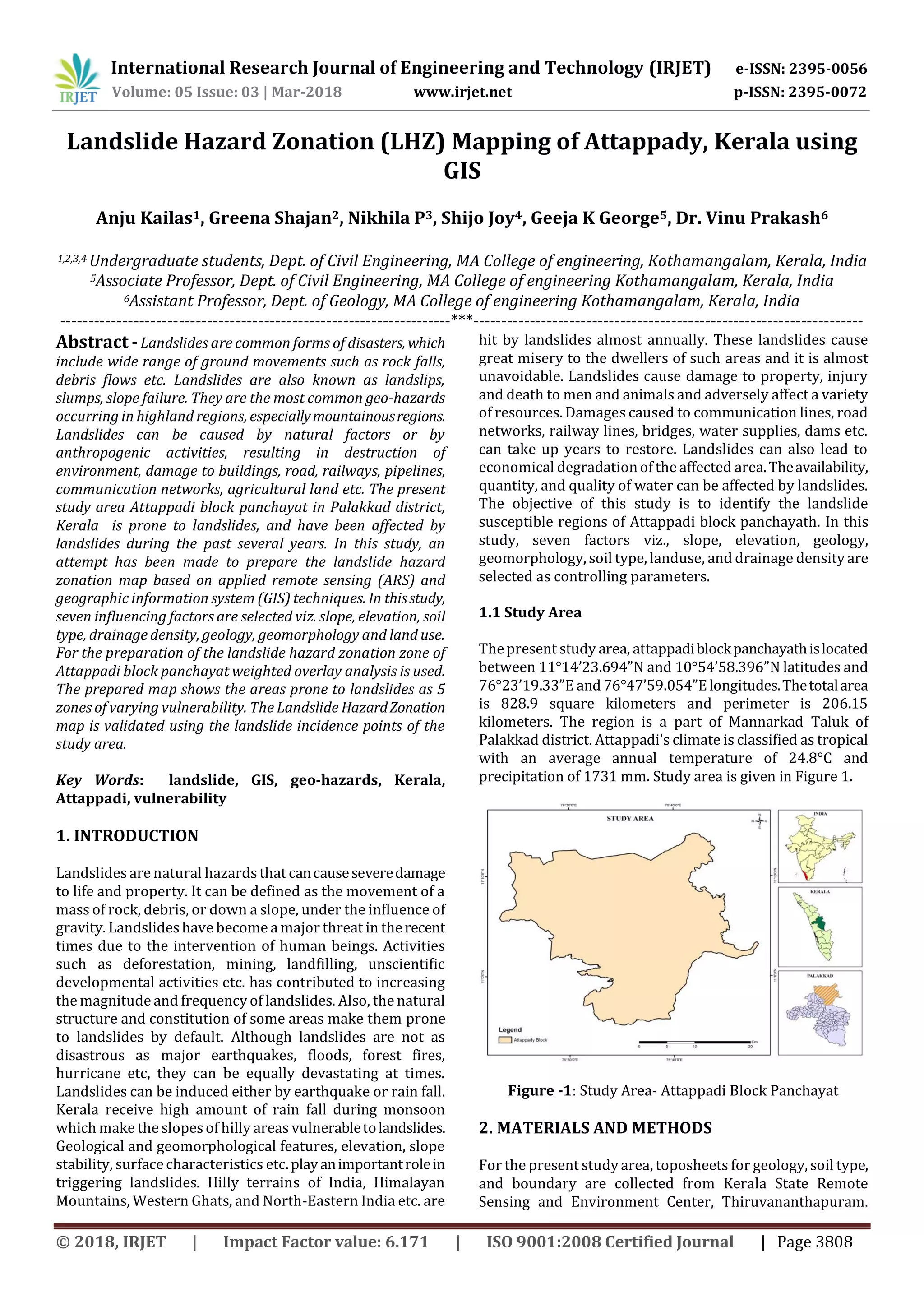
3.6 Drainage Density
Drainage density is a factor which is indicative of
perviousness of strata, rainfall, vegetation and stream
incision. All these factors are directly related to mass
movement. High drainage density is an indication of
impervious strata, high rainfall, less vegetation and active
stream incision. The thematic drainagedensitymapisshown
in Figure 7.
Figure -7: Drainage Density Map
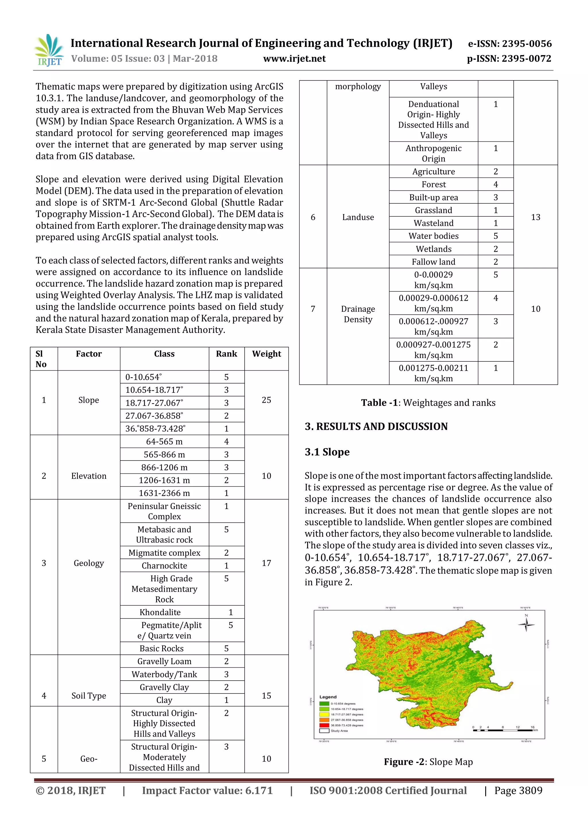
3.7 Landuse
Landuse/Landcover is one of the key factors affecting
landslide. Often, the changes brought by anthropogenic
activities cause rapid changes in the stability of a landform.
Activities like deforestation, unscientific cultivation
practices, urbanization, land reclamation etc. influence the
incidence of landslides. Areas with sparse vegetation are
more prone to landslide in contrast to densely vegetated
areas due to more erosion. Chances of landslide depend
upon the amount of water infiltrated to geomorphologically
unstable slopes with loose soil and weak rocks.Thethematic
landuse/landcover map is shown in Figure 8.
Figure -8: Landuse Map
Based on the weighted overlay analysis done on the seven
selected parameters, the output map is generated.Thestudy
area isthus classified into 5 zoneswith varying vulnerability
viz., very high susceptible zone, highly susceptible zone,
moderately susceptible zone, low susceptible zone and very
low susceptible zone.
4. CONCLUSION
Regions like Attappadi where the population density is less,
the preventive measures taken for the recurring landslides
are relatively low. When landslides and such disasters hit
them, usually people get isolated. The communication and
transport systems often get hindered making their life
miserable during the time of such disasters. Using remote
sensing and GIS techniques, effective demarcation of
landslide hazard zones can be done. Thus the mitigation
measures can be precisely done and the management of
landslide hazard is made easy.
From this study it is found that the north, north-eastern and
the southern regions of Attappadi block panchayat aremore
prone to landslides. It is clear that slope and elevation are
the most important causative factors followed by drainage
density, geology, soil type, geomorphology and landuse.The
prepared landslide hazard zonation map is validated based
on the natural hazard zonation map of Kerala, prepared by
Kerala State Disaster Management Authority. Hence this
methodology can be used for further studies on other
regions.
The prepared LHZ map may be useful to planners and
developers for choosing suitable site for future
developments and landuse planning, and also to locate
constructions in the unstable zones. It could be of use for
authorities of the area for ensuring safety to the people of
affected regions.
Constant monitoring for geo-hazards is necessary in
strategically important places and location of major dams,
pipelines, important structures and monuments. Hazard
zonation mapping using GIS and remote sensing techniques
provide latest and reliable information regarding the same.
REFERENCES
[1] Ganapathy, G.P., Mahendran, “Need and Urgency of
Landslide Risk Planning for Nilgiri District, Tamil nadu
state India”, International journal of geomatics and
geosciences volume 1, pp.29-40, (2010).
[2] Raveendran, Dr. Mani, Aneesh, “Landslide Hazard
Zonation and Vulnerability Assessment of Western
Ghats- A case study in Devikulam Taluk of Idukki
District”, International journal of research and applied
sciences, volume 5, pp.185-189, (2015).
[3] Ahmed B, “Landslide susceptibility mapping using
multi-criteria evaluation techniques in Chittagong](https://image.slidesharecdn.com/irjet-v5i3891-190206082508/75/IRJET-Landslide-Hazard-Zonation-LHZ-Mapping-of-Attappady-Kerala-using-GIS-4-2048.jpg)
![International Research Journal of Engineering and Technology (IRJET) e-ISSN: 2395-0056
Volume: 05 Issue: 03 | Mar-2018 www.irjet.net p-ISSN: 2395-0072
© 2018, IRJET | Impact Factor value: 6.171 | ISO 9001:2008 Certified Journal | Page 3812
Metropolitan Area, Bangladesh”, Landslides.
doi: 10.1007/s10346-014-0521 (2014)
[4] Ayalew L, Yamagishi H, Ugawa N, “Landslide
susceptibility mapping using GIS-based weighted linear
combination, the case in Tsugawa area of Agano River,
Niigata Prefecture, Japan”, Springer 2004:34,( 2004)
[5] Cevik E., Topal T, “GIS-based landslide susceptibility
mapping for a problematic segment of the natural gas
pipeline, Hendek (Turkey)”, Environmental Geology 44,
pp. 949- 962, (2003)
[6] Ajin R.S., Vinod P.G., Menon A.R.R, “Landslide Hazard
Zonation using RS and GIS techniques: A case study of
Meenachil and Kanjirappally Taluk, Kottayam district,
Kerala, India”, Proceedings of the 26th Kerala Science
Congress, Pookode, Wayanad (India), pp. 1797- 1804,
(2014)
[7] Akgun A., Bulut F., “GIS-Based Landslide Susceptibility
For Arsin-Yomra (Trabzon, North Turkey) Region”,
Environmental Geology 51, pp. 1377-1387, (2007)
[8] Chingkhei R.K., Shiroyleima A., Singh L.R., Kumar A,
“Landslide hazard zonation in NH-1A in Kashmir
Himalaya, India”, International JournalofGeosciences 4,
pp. 1501-1508, (2013)
[9] Dai F.C., Lee C.F., Li J., Xu Z.W, “Assessment of landslide
susceptibility on the natural terrain of Lantau Island,
Hong Kong”, Environmental Geology 40, pp. 381-391,
(2001)
[10] Dutta P.J., Sarma S., “Landslide susceptibility zoning of
the Kalapahar hill, Guwahati, Assam state, India, using a
GIS-based heuristic technique”, International Journal of
Remote Sensing & Geoscience 2(2), pp. 49-55, (2013)](https://image.slidesharecdn.com/irjet-v5i3891-190206082508/75/IRJET-Landslide-Hazard-Zonation-LHZ-Mapping-of-Attappady-Kerala-using-GIS-5-2048.jpg)

This document describes a study that used GIS and remote sensing techniques to create a landslide hazard zonation map of Attappady block panchayat in Kerala, India. Seven factors that influence landslide occurrence were considered: slope, elevation, soil type, geology, geomorphology, land use, and drainage density. Spatial data layers for each factor were created and assigned weights based on their landslide susceptibility. A weighted overlay analysis was performed to combine the factors and produce a map depicting five zones of varying landslide vulnerability. The map identified the northern, northeastern, and southern regions as most prone to landslides. The study found slope, elevation, and drainage density to be the most important triggering factors. The produced


