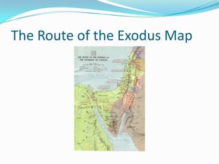
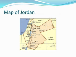
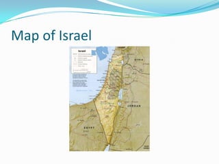
The Israelite Exodus From Egypt
Egypt and Sinai Peninsula
 Our journey starts in Egypt, where the Israelites lived
  for 430 years before the Exodus (c. 1446 BC).
 From Cairo, we retraced the route followed by Moses
  through the wilderness to Mount Sinai - home to St.
  Catherine, the oldest Christian Monastery in the
  world. It was built during the reign of Emperor
  Justinian (527-565 AD) on the site where Moses
  encountered the burning bush.
The Route of the Exodus Map
Mount Sinai
 The “Burning Bush” growing at St. Catherine is believed to
  be from the original root-stock of the bush from which
  GOD identifies himself to Moses and orders him back to
  Egypt to lead the Israelites out of captivity.
 After leading the Israelites out of Egypt, Moses returns to
  Mt. Sinai where GOD gives him the Ten Commandments
  written on stone tablets; plans for building the Ark of the
  Covenant in which to house the stone tablets; and
  instructions for building a tabernacle.
 Our over-night trek up Mt. Sinai took 31/2 hours on camel-
  back followed by a climb of 750 steps to reach the summit
  of the mountain just before sunrise.
Mount Sinai to Jordan
 Heading north toward Jordan, we crossed through the
  Wilderness of Paran, where the Israelites continued to
  wandered for 40 years - as a death sentence for those who
  refused to enter the Promised Land when they first had the
  chance to do so. They were placed in a “holding pattern”
  until all of the disobedient and cowardly ones of adult age
  had died off (Numbers 32:10-13).
 Traveling from Egypt to Jordan requires crossing through
  Eilat, Israel - a 10 mile stretch - from the Taba Border
  station to the Wadi Araba Border station. Formalities at
  the Egyptian, Israeli, and Jordanian border crossing
  stations took about 21/2 hours.
The Kings Highway
 Crossing into Jordan, we continued to Petra via the
  Kings Highway - an ancient Incense Route that linked
  the Mediterranean world with the Eastern sources of
  incense and spices. Frankincense and Myrrh, two of
  the items actively traded along this route, are aromatic
  resins from trees growing in Arabia and are used as
  incense and perfumes.
 The “Three Wise Men” might have traveled this route
  with their gifts for baby Jesus.
Map of Jordan
Land of the Edomites and Moabites
 Petra, established around 1500 BC, was an ancient city
  carved from the mountains along the border of the
  Kingdoms of Edom and Moab. Edomites (Hebrew for red
  people) were descendants of Esau, son of Isaac. Moabites
  were descendants of Lot, son of Haram, and Lot’s older
  daughter. The settlement was captured by the Nabataeans
  (ancient nomadic tribes from Arabia) in the 6th century BC
  to control the incense and spice trade along the Kings
  Highway.
 In 1917, T.E. Lawrence (Lawrence of Arabia) led a group of
  Syrians and Arabians defending Petra from the Turks &
  Germans.
Petra to Tel Aviv
 From Petra, we headed north to Amman, Jordan , and
  then to Mt. Nebo, where Moses first saw the Promised
  Land. Moses died without entering the Promised Land
  and Joshua assumed command of the Israelites.
 We crossed the Israel border at the Allenby Bridge just
  east of Jericho, and continued westward to the ancient
  coastal city of Jaffa (Joppa) – just south of Tel Aviv –
  one of the oldest port cities on earth. Cedars of
  Lebanon that were used in the construction of
  Solomon’s Temple were landed at Joppa.
Map of Israel
Tel Aviv to Tiberius
 From Tel Aviv, we traveled north to the ancient port city of
  Caesarea. Built by Herod the Great, as Caesarea Maritima,
  it was the center of early Christianity. Here, the Apostle
  Peter baptized the first Gentile convert to Christianity —
  Cornelius, a centurion in the Roman army.
 Next we headed east to Tiberius on the banks of the Sea of
  Galilee. Along the way we stopped at Mount Carmel (where
  Elijah challenged the false prophets); Megiddo (ancient
  city that was built and destroyed 25 times); the Jezerel
  Valley (where the Battle of Armageddon will be fought);
  Nazareth (home village of Joseph and May); and Cana of
  Galilee, (where Jesus performed his first miracle – water to
  wine for the wedding).
Sea of Galilee
 We spent two days sightseeing around the Sea of
  Galilee that included visits to Capernaum (where Jesus
  preformed many of his miracles), Mount of Beatitudes
  (where Jesus preached the Sermon on the Mount),
  Church of the Multiplication (where Jesus fed the
  multitudes with 5 loaves and 5 fishes), and Caesarea
  Philippi (where Jesus first revealed himself to Peter as
  the Messiah).
 One of the highlights was sailing around the Sea of
  Galilee on a “Jesus Boat”.
Map of Galilee
Sea of Galilee to the Dead Sea
 Following the Jordan River southward, we stopped at Yardenit
  (little Jordan), a baptismal site on the Jordan River, where some
  believe Jesus was baptized by John the Baptist.
 Further south, we visited Beih Shean, the Canaanite city that was
  conquered by the Philistines, in the 11th Century BC. Later, in
  the 11th century, King Saul's body was displayed on the city walls
  after his defeat by the Philistines.
 Overlooking the Dead Sea, at Qumran, we saw the caves where
  the Dead Sea Scrolls were discovered by a shepherd boy in 1947.
 We rode a cable car to the top of Masada - famous for being the
  site of the last stronghold of the Jewish Rebellion against the
  Romans in 63 AD.
Jerusalem and Bethlehem
 We spent three days in Jerusalem visiting many
  biblical sites including: Mount of Olives, Garden of
  Gethsemane, the Old Walled City, Mount Zion,
  Church of the Holy Sepulchre, and we walked the Via
  Dolorosa, which is held to be the path that Jesus
  walked, carrying his cross, on the way to his
  crucifixion.
 In Bethlehem, we visited the birth place of Jesus at the
  Church of the Nativity.
Interesting Israel Facts
 The State of Georgia has 59,000 square miles of
  territory and 9 million residents.
 Metro Atlanta has 8,000 square miles of territory and 5
  million residents.
 The State of Israel has 8,000 square miles of territory
  and 7 million residents, but 4,000 square miles of
  Israel's territory is uninhabitable desert areas.
 The distance from Nazareth to Capernaum is 6 miles –
  an easy half-day walk. Jesus grew-up, lived most of this
  life, and conducted most of his Ministry within this
  area of Galilee.
Israel vs State of Georgia
Size Comparison
Into the Promised Land
DVD Musical Selections
 Sara Brightman:
    It’s A Beautiful Day
    Deliver Me
    Who Wants To Live Forever
    A Questions of Honour
    Just Show Me How To Love You
 Celine Dion:
    Miles To Go Before I Sleep
    Where Is the Love
    Love Is On The Way
    Tell Him (duo with Barbara Streisand)
 Susan Boyle:
    How Great Thou Art
    Amazing Grace
 Elefante Beville
    I Will Follow You
Into The Promised Land
DVD Titles and Bible References
 The DVD shows highlights of our tour of the Holy
 Lands and contains titles and bible references to
 describe each of the sites visited.

                       Thank You
              Please Enjoy the Presentation

Into the Promised Land

  • 1.
  • 2.
    Egypt and SinaiPeninsula  Our journey starts in Egypt, where the Israelites lived for 430 years before the Exodus (c. 1446 BC).  From Cairo, we retraced the route followed by Moses through the wilderness to Mount Sinai - home to St. Catherine, the oldest Christian Monastery in the world. It was built during the reign of Emperor Justinian (527-565 AD) on the site where Moses encountered the burning bush.
  • 3.
    The Route ofthe Exodus Map
  • 4.
    Mount Sinai  The“Burning Bush” growing at St. Catherine is believed to be from the original root-stock of the bush from which GOD identifies himself to Moses and orders him back to Egypt to lead the Israelites out of captivity.  After leading the Israelites out of Egypt, Moses returns to Mt. Sinai where GOD gives him the Ten Commandments written on stone tablets; plans for building the Ark of the Covenant in which to house the stone tablets; and instructions for building a tabernacle.  Our over-night trek up Mt. Sinai took 31/2 hours on camel- back followed by a climb of 750 steps to reach the summit of the mountain just before sunrise.
  • 5.
    Mount Sinai toJordan  Heading north toward Jordan, we crossed through the Wilderness of Paran, where the Israelites continued to wandered for 40 years - as a death sentence for those who refused to enter the Promised Land when they first had the chance to do so. They were placed in a “holding pattern” until all of the disobedient and cowardly ones of adult age had died off (Numbers 32:10-13).  Traveling from Egypt to Jordan requires crossing through Eilat, Israel - a 10 mile stretch - from the Taba Border station to the Wadi Araba Border station. Formalities at the Egyptian, Israeli, and Jordanian border crossing stations took about 21/2 hours.
  • 6.
    The Kings Highway Crossing into Jordan, we continued to Petra via the Kings Highway - an ancient Incense Route that linked the Mediterranean world with the Eastern sources of incense and spices. Frankincense and Myrrh, two of the items actively traded along this route, are aromatic resins from trees growing in Arabia and are used as incense and perfumes.  The “Three Wise Men” might have traveled this route with their gifts for baby Jesus.
  • 7.
  • 8.
    Land of theEdomites and Moabites  Petra, established around 1500 BC, was an ancient city carved from the mountains along the border of the Kingdoms of Edom and Moab. Edomites (Hebrew for red people) were descendants of Esau, son of Isaac. Moabites were descendants of Lot, son of Haram, and Lot’s older daughter. The settlement was captured by the Nabataeans (ancient nomadic tribes from Arabia) in the 6th century BC to control the incense and spice trade along the Kings Highway.  In 1917, T.E. Lawrence (Lawrence of Arabia) led a group of Syrians and Arabians defending Petra from the Turks & Germans.
  • 9.
    Petra to TelAviv  From Petra, we headed north to Amman, Jordan , and then to Mt. Nebo, where Moses first saw the Promised Land. Moses died without entering the Promised Land and Joshua assumed command of the Israelites.  We crossed the Israel border at the Allenby Bridge just east of Jericho, and continued westward to the ancient coastal city of Jaffa (Joppa) – just south of Tel Aviv – one of the oldest port cities on earth. Cedars of Lebanon that were used in the construction of Solomon’s Temple were landed at Joppa.
  • 10.
  • 11.
    Tel Aviv toTiberius  From Tel Aviv, we traveled north to the ancient port city of Caesarea. Built by Herod the Great, as Caesarea Maritima, it was the center of early Christianity. Here, the Apostle Peter baptized the first Gentile convert to Christianity — Cornelius, a centurion in the Roman army.  Next we headed east to Tiberius on the banks of the Sea of Galilee. Along the way we stopped at Mount Carmel (where Elijah challenged the false prophets); Megiddo (ancient city that was built and destroyed 25 times); the Jezerel Valley (where the Battle of Armageddon will be fought); Nazareth (home village of Joseph and May); and Cana of Galilee, (where Jesus performed his first miracle – water to wine for the wedding).
  • 12.
    Sea of Galilee We spent two days sightseeing around the Sea of Galilee that included visits to Capernaum (where Jesus preformed many of his miracles), Mount of Beatitudes (where Jesus preached the Sermon on the Mount), Church of the Multiplication (where Jesus fed the multitudes with 5 loaves and 5 fishes), and Caesarea Philippi (where Jesus first revealed himself to Peter as the Messiah).  One of the highlights was sailing around the Sea of Galilee on a “Jesus Boat”.
  • 13.
  • 14.
    Sea of Galileeto the Dead Sea  Following the Jordan River southward, we stopped at Yardenit (little Jordan), a baptismal site on the Jordan River, where some believe Jesus was baptized by John the Baptist.  Further south, we visited Beih Shean, the Canaanite city that was conquered by the Philistines, in the 11th Century BC. Later, in the 11th century, King Saul's body was displayed on the city walls after his defeat by the Philistines.  Overlooking the Dead Sea, at Qumran, we saw the caves where the Dead Sea Scrolls were discovered by a shepherd boy in 1947.  We rode a cable car to the top of Masada - famous for being the site of the last stronghold of the Jewish Rebellion against the Romans in 63 AD.
  • 15.
    Jerusalem and Bethlehem We spent three days in Jerusalem visiting many biblical sites including: Mount of Olives, Garden of Gethsemane, the Old Walled City, Mount Zion, Church of the Holy Sepulchre, and we walked the Via Dolorosa, which is held to be the path that Jesus walked, carrying his cross, on the way to his crucifixion.  In Bethlehem, we visited the birth place of Jesus at the Church of the Nativity.
  • 16.
    Interesting Israel Facts The State of Georgia has 59,000 square miles of territory and 9 million residents.  Metro Atlanta has 8,000 square miles of territory and 5 million residents.  The State of Israel has 8,000 square miles of territory and 7 million residents, but 4,000 square miles of Israel's territory is uninhabitable desert areas.  The distance from Nazareth to Capernaum is 6 miles – an easy half-day walk. Jesus grew-up, lived most of this life, and conducted most of his Ministry within this area of Galilee.
  • 17.
    Israel vs Stateof Georgia Size Comparison
  • 18.
    Into the PromisedLand DVD Musical Selections  Sara Brightman:  It’s A Beautiful Day  Deliver Me  Who Wants To Live Forever  A Questions of Honour  Just Show Me How To Love You  Celine Dion:  Miles To Go Before I Sleep  Where Is the Love  Love Is On The Way  Tell Him (duo with Barbara Streisand)  Susan Boyle:  How Great Thou Art  Amazing Grace  Elefante Beville  I Will Follow You
  • 19.
    Into The PromisedLand DVD Titles and Bible References  The DVD shows highlights of our tour of the Holy Lands and contains titles and bible references to describe each of the sites visited. Thank You Please Enjoy the Presentation