Download to read offline


![40.
I
I
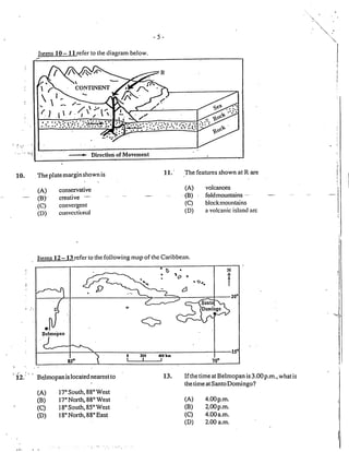
The sequence of plate movements above is{
MOST likely to result in the formation of i
-12-
cues[as
fault scarps
clay vales
foldrnountains
l,
(A)
(B)
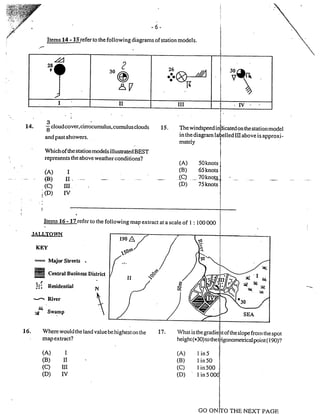
(c)
(D)
Item 4l refers to the
"U"*,"r
r*n 42. Wlrichof tlre fol ing rvould haveits HIGFI-
ESTpopulation iry in thedaytime?
Which of the fol lowing cli rnaric types is MOST
likely to be experienced in the area shadecl
l// onthemap above?
(A) Equatorial
(B) TropicalMarine
(C) TropicalContinental
(D) Tropicallvlonsoon
(A) Asquatiersettlement
(B) Anrralfishingvillage
(C) A suburban rc.siclential arca
(D) Alrurb:rhcorrrrncrciirlccntrc
I
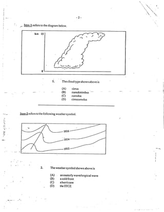
'l'lrc tc.rnpcr-aturJ sucltlcnly clrop.s antl rvirrtl
spccd r ncrcnscsilthc sky gracluully bccorncs
ovcrcil.st and thcic is a sliglrt drizzlc.
Vhat type of r,rfather systcnl is clescribect
above?
I
I
(A) Cold frorlt
(B) Easterlyfivave/tropical rvave
(C) Flurricarh
(D) Inter-tro$ical con vcrgence zone
It
It
I
I
]l
I
il
I
_,ogg.ryL'_g.Iy=q.N_EII.t+s_E
.1.].
4t.
._ b4Q refers to the following series of diagrarns.
i l-]
i 15""JI
i !sHr,
; l_JsrrrA
J --> Direction of plate
i movement](https://image.slidesharecdn.com/csecgeographyjune2003p1-200528041930/85/CSEC-GEOGRAPHY-PAPER-1-2003-12-320.jpg)


This document appears to be an exam for a geography test, consisting of 60 multiple choice questions. It provides instructions for how to fill in answers on an answer sheet, noting students should blacken the corresponding letter for the best answer choice. It informs examinees they will have 75 minutes to complete the test. The document contains sample exam questions on topics including weather symbols, grid references, plate tectonics, climate graphs, and vegetation belts.