Download to read offline
![IJRET: International Journal of Research in Engineering and Technology eISSN: 2319-1163 | pISSN: 2321-7308
_______________________________________________________________________________________
Volume: 04 Issue: 02 | Feb-2015, Available @ http://www.ijret.org 41
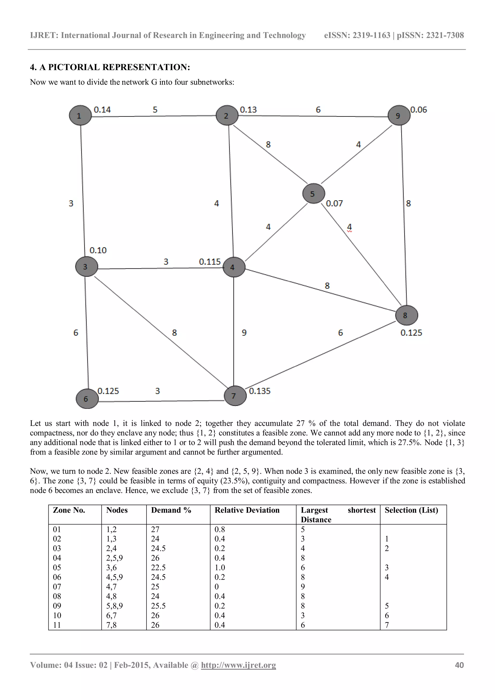
Now, we suppose we minimize the total relative deviation. We start at the first section of given table, namely all the zones whose
root node is node 1. We call this set of zones list 1. Among them, zone 2 is preferred since it incurs a relative deviation 0.4. So, we
mark zone 2, tentatively, as a candidate zone and we record that node 1 and 3 are now covered.
Since node 2 is not covered, we have to select a zone from the second section list 2, while avoiding double coverage. A preferred
candidate zone is 3, whose deviation is equal to 0.2. The list of covered nodes now includes {1, 2, 3, 4 }.
The next not-covered node is 5, so we turn to the fifth section list 5 of the table and zone 9 to our candidate set. The covered nodes
are {1, 2, 3, 4, 5, 8, 9} .
We now have to examine node 6 and select zone 10 to the candidate partitioning. All the nodes are now covered and the
partitioning is mutually exclusive. The candidate zones are {2, 3, 9, 10}, the total deviation is 1.2, hence average deviation is 1.2/4
= 0.3.
The zones {2, 3, 9, 10} constitute the optimal partitioning.
5. CONCLUSION
In the public sector like ambulance, fire, police and the other
services and in the private sector like courier, taxi, repair,
maintenance etc., when we start a service policy, our first
aim is to partition a network, into smaller subnetworks. By
partitioning a network into subnetworks, we can provide
service to the public easily. Here the term “Net-work”
connotes geographical distributions namely different places
located in a certain area, these are called Nodes. Nodes can
be cities in a state, blocks within a neighbourhood, a police
headquarter or police check post for a specified area etc.
With the help of the mathematical model, we can partition a
network into subnetworks.
REFERENCES
[1] Richard C. Larson, Amedeo R. Odoni, “Urban
Operation Research”, 1981.
[2] Ahituv, N, and O. Berman “Quantitative Models for
Policy Making in Urban Emergency Networks”,
International Journal of Policy and Information,
6(2), pp. 35-42 (1982).
[3] Battey, M., (1971),”Modelling cities and Dynamic
Systems”, Nature, 321, pp 425-428 (1976),”Urban
Modelling, Algorithms, Calibrations, Predictions”,
Cambridge University Press, Cambridge, England
(1979).](https://image.slidesharecdn.com/amathematicalformulationofurbanzoningselectioncriteriainadistributedservicenetwork-160829115109/75/A-mathematical-formulation-of-urban-zoning-selection-criteria-in-a-distributed-service-network-4-2048.jpg)
![IJRET: International Journal of Research in Engineering and Technology eISSN: 2319-1163 | pISSN: 2321-7308
_______________________________________________________________________________________
Volume: 04 Issue: 02 | Feb-2015, Available @ http://www.ijret.org 42
[4] Battey, M., Bourke, R. Cormode, Anderson, P and
M, Nicholis,”Experiments in Urban Modelling for
Country Structure Planning : The Area of 8 Pilot
Model”, Environment and Planning A, 6, pp. 455-
478 (1974).
[5] Garfinkel, R.S. and G.L. Nemhauser,”Optimal
Districting by Implicit Enumeration Teachnique”,
Mgmi. Sci. 16, pp. 495-508 (1970).
[6] Mirchandani, P.B.,”Analysis of Stochastic Networks
in emergency Service System”, IRP. TR-15-75.
Operations Research Centre, Massachusetts Institute
of Teachnology, Cambridge, Mass.(1975).
[7] Battey, M, and I. Masser,”Spatial Decompositions
and partitions in Urban Modelling”, in Cripps,
E.L.,(ed.), Regional Science-New Concepts and Old
problems, London Papers in Regional Science, 5,
Pion, London pp. 188-206 (1975).
[8] Singh, A.P, “Innovative Resource Planning Project
in Distributed Service Network, An Operational
Research Apporach”, (2000).](https://image.slidesharecdn.com/amathematicalformulationofurbanzoningselectioncriteriainadistributedservicenetwork-160829115109/75/A-mathematical-formulation-of-urban-zoning-selection-criteria-in-a-distributed-service-network-5-2048.jpg)

This document presents a mathematical formulation for zoning or partitioning a distributed service network into subnetworks. It describes various zoning criteria like demand equity, contiguity, compactness and avoiding enclaves that must be considered. An objective function is defined to minimize the maximum relative demand deviation between zones, subject to constraints. A pictorial example is provided to demonstrate the zoning process. The formulation allows a network to be optimally partitioned into zones based on defined criteria.