T4501109116
•
0 likes•237 views

International Journal of Engineering Research and Applications (IJERA) is an open access online peer reviewed international journal that publishes research and review articles in the fields of Computer Science, Neural Networks, Electrical Engineering, Software Engineering, Information Technology, Mechanical Engineering, Chemical Engineering, Plastic Engineering, Food Technology, Textile Engineering, Nano Technology & science, Power Electronics, Electronics & Communication Engineering, Computational mathematics, Image processing, Civil Engineering, Structural Engineering, Environmental Engineering, VLSI Testing & Low Power VLSI Design etc.

Recommended
Recommended
More Related Content
What's hot
What's hot (20)
Viewers also liked
Viewers also liked (20)
Similar to T4501109116
Similar to T4501109116 (20)
Recently uploaded
Recently uploaded (20)
T4501109116
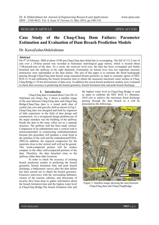
- 1. Dr. K Abdulrahman Int. Journal of Engineering Research and Applications www.ijera.com ISSN : 2248-9622, Vol. 4, Issue 5( Version 1), May 2014, pp.109-116 www.ijera.com 109|P a g e Case Study of the Chaq-Chaq Dam Failure: Parameter Estimation and Evaluation of Dam Breach Prediction Models Dr. KawaZedanAbdulrahman Abstract On 4th of February, 2006 at about 10:00 pm.Chaq-Chaq dam failed due to overtopping. The fall of 131.2 mm of rain over a 24-hour period was recorded at Sulaimani metrological gage station, which is located about 7.5Kmsouth-east of the dam. As a result, the reservoir level rose, the dam has been overtopped and finally breached near the spillway at the right abutment. Fortunately no human lives loss nor important structure destruction were reporteddue to the dam failure. The aim of this paper is to estimate the flood hydrograph passing through Chaq-Chaq dam breach using measured breach geometry as input to unsteady option of HEC RAS 4.1.0 and calibrating the breach formation time to obtain the measured maximum water surface at Chaq- Chaq Bridge (1.36 km downstream of dam axis). In addition the recent breach prediction models were evaluated to check their accuracy in predicting the breach geometry, breach formation time and peak breach discharge. I. Introduction Chaq-Chaq dam is located about 2 km NE of Sulaimani city (Iraq). Fig. 1 shows a satellite image of the area between Chaq-Chaq dam and Chaq-Chaq Bridge.Chaq-Chaq dam is a zoned earth dam of central clay core and gravelly shell as shown in Fig.2. Chaq-Chaq dam was designed and built by engineers of little experience in the field of dam design and construction. As a recognized design problem,one of the major mistakes was the building of the spillway beside the dam in the same valley not as a separate structure. The spillway wall has been made vertical. Compaction of an embankment near a vertical wall is notrecommended in constructing embankmentdams because this procedure will produce a weak bond at the interface of the wall and the embankment(FEMA, 2005).In addition; the required compaction for the materials close to the vertical wall will not be gained. This weak-compacted portion will be weaker compare to the other well-compacted portions of the dam. Therefore, the dam breached close to the spillway rather than other locations. In order to check the accuracy of existing breach prediction models in predicting the breach geometry, breach formation time and peak breach discharge; a bathymetric survey after the dam failure has been carried out to obtain the breach geometry. Extensive interviews with the surrounding habitants, owners of the tourism cabinets, and directorate of security have been done to gather information about the breach formation time and the highest water level at Chaq-Chaq Bridge.The breach formation time and the highest water level at Chaq-Chaq Bridge is used as input to calibrate the HEC RAS 4.1 (Brunner, 2010 a,b) to achieve the maximum flood discharge passing through the dam breach as it will be presented as the followings. Figure 1: Satellite image showing the area between Chaq-Chaq dam and Chaq-ChaqBridge. RESEARCH ARTICLE OPEN ACCESS
- 2. Dr. K Abdulrahman Int. Journal of Engineering Research and Applications www.ijera.com ISSN : 2248-9622, Vol. 4, Issue 5( Version 1), May 2014, pp.109-116 www.ijera.com 110|P a g e Figure 2: Photo of Chaq- Chaq dam after failure. II. Breach GeometryData Bathymetric survey has been carried out to obtain the breach geometries;Table 1 shows the geometry parameters of Chaq-Chaq dam and its breach. Table 1: Geometry parameters of Chaq-Chaq dam. Parameter Height of dam H (m) Top width (m) Upstream slope (v:h) Downstream slope (v:h) Breach Bottom width (m) Breach Average width (m) Breach Top width (m) Dam crest level (masl) Value 14.5 9 1:3 1:2 29.6 38 46 780 III. Breach hydraulic data Due to insufficient spillway capacity Chaq- Chaq dam was overtopped and then failed. According to a local witness (who was the formal responsible of the dam and his house was located about 100 m far from the dam) the maximum depth of water above the dam crest was between 0.5 − 0.6 m. So, he was also estimated the breach formation time to be between 1 to 1.5 hours. In addition the maximum water level due to the dam failure flood at Chaq-Chaq bridge which is located about 1.36 km downstream of the dam has been decided based on eyewitness accounts. The maximum water level at the bridge was around 759.4-759.5maslas corresponded to 20-30 cm below the lower cord of the bridge. There was a security team at the bridge to prevent peoples from passing the bridge because there was a potential of bridge failure due to the flood before and during the dam failure. The flood extent at the bridge was seen by the security team. Table 2 shows some of the hydraulic parameters of Chaq-Chaq dam and Chaq- Chaq Bridge. Table 2: Hydraulic parameters of the Chaq-Chaq dam and bridge. Para meter Depth of overt oppin g (m) Breach formati on time (hr) Reservoir storage at NPL El. 777.5 MCM Reservoir storage at El. 780.0 MCM Reservoir storage at El. 780.6 MCM Spillway length (m) Spillwa y crest level (masl) Minimum stream bed level at the bridge (masl) High cord level of the bridge (masl) low cord level of the bridge (masl) Maxim um water level at the bridge (masl) Value 0.6 1-1.5 1.4 2.344 2.55 15 777.5 754.4 761 759.7 759.6 Flow Direction Spillway Dam BodyCore Shell
- 3. Dr. K Abdulrahman Int. Journal of Engineering Research and Applications www.ijera.com ISSN : 2248-9622, Vol. 4, Issue 5( Version 1), May 2014, pp.109-116 www.ijera.com 111|P a g e IV. Upstream and downstream cross sections data One-dimensional dam breach hydraulic modelof HEC-RAS is used frequentlyto predict the flood inundation area due to a dam breachflood through the downstream valley. It was found thatHEC-RAS performed well, with relatively good agreement between predicted and measured water levels(Yochum etal.,2008) and(Gee, 2010). HEC-RAS modeling system is a public domain model developed by the US Army Corp of Engineers (Brunner, 2010 a,b). It performs one- dimensional (1D) steady and unsteady flow simulations on a full network of natural or man-made open channels. Additionally, it has the ability to model storage areas and dam break problems as well as bridges and culverts hydraulics. In order to model the flooding in the stream valley using HEC‐RAS; cross sections data are required. In this study a topographic map of 1m interval is obtained in AutoCAD format from the municipality of Sulaimanya.Then, the river reach in the Chaq-Chaq system extending over a length of 4.15 km from upstream end of the reservoir to the downstream portion of the damis considered for analysis. The cross sections data of the river reach aredeveloped by AutoCAD Civil 3D 2013, by using this software the main channel as well as right and left overbank have beennoted and coded in the hydraulic model. A number of 21 cross sections at the upstream of the dam are used to model the reservoir area and19 cross sections were developed at the downstream portion. Extra cross sections were added by interpolation at a maximum distance of 75 m. The values of Manning’s roughness coefficient were entered directly into the cross section editor to describe the channel and overbanks. These values were determined by visual inspection and satellite imagesbased on guidance fromChow (1959). The Manning’s roughness coefficient values were set at 0.028 for main channel and the two overbanks. These values have been assumed because the stream reach under study is clean with stones and high flow stages are expected during the dam break analysis (Parhi etal, 2012). V. HEC-RAS Model The unsteady option of HEC-RASrequires the breach geometry and breach formation time as input in order to model a dam breach flood.The breach geometry is readily available from the bathymetric survey but breach formation time is still a matter of uncertainty (1-1.5 hrs). Breach formation time is the most sensitive parameter in developing a hydraulic model for dam break problems and breach hydrograph development. Therefore, in this study it is attempted to calibrate the breach formation time through simulation of breach flood using HEC-RAS 4.1 unsteady model. For calibration of Breach formation time value; the observedWSE at the downstream bridge has been considered. A weir coefficient of 1.1 was used in this analysis; the trigger time of breach is set such that it corresponds to the time of peak of a developed inflow hydrograph as it will be explained in the next paragraph. At that time the water surface elevation was equal to 780.57 m which is close to the observed water surface elevation ( 780.5 − 780.6 m). This equality in the simulated and the observed WSE proves that the developed inflow hydrograph is accurate and that there was under-estimate for the inflow hydrograph in the design of Chaq-Chaq Dam. VI. Boundary conditions The upstream boundary condition is modeled using the flood hydrograph corresponding to the measured 131.2 mm rainfall depth during 24 hrs on a 151 𝑘𝑚2 of catchment area. The flood hydrograph is developed from contributing catchments using NRCSunit hydrograph (UH) method. The NRCS dimensionless UH is a synthetic unit hydrograph in which the discharge is expressed by the ratio of discharge to peak discharge and the time by the ratio of time to the time of rise of the unit hydrograph(Chow etal., 1988). Fig.3 shows the developed inflow flood hydrograph. Details on how to develop flood hydrograph using NRCS UH can be found in McCuin (2005). The downstream boundary condition is set to normal depth and an approximate water surface slope is assumed for the friction slope.
- 4. Dr. K Abdulrahman Int. Journal of Engineering Research and Applications www.ijera.com ISSN : 2248-9622, Vol. 4, Issue 5( Version 1), May 2014, pp.109-116 www.ijera.com 112|P a g e Figure 3: Inflow flood hydrograph. VII. Initial conditions The WSE upstream of the dam is set to 780 m which is the crest elevation of the dam; while WSE at the downstream reach is set such that 2 m depth of water is existing. VIII. Hydraulic model result Using of surveyed dam breach geometry combined with standard approaches for developing the upstream hydrograph boundary conditiona HEC RAS model was developed to generate different breach hydrograph corresponding to different breach formation times, namely 1.25 hrs, 1.50hrsand 1.60hrs.Fig. 4 provides a plot of modeled water surface profiles at different times of the simulation and Fig. 5 shows the outflow flood hydrograph through the dam breach. Each hydrograph was routed through the downstream reach to produce different water surface elevations at the downstream bridge; the results of the model at the bridge location are shown in Table 3. The percentage of errorsbetween the predicted water surface elevation and theobservedwater surface elevation at the downstream bridge are depicted in the Table 4. Figure 4: water surface profiles at different times of simulation corresponding to 1.6 hrsof breach formation time. 0.00 20.00 40.00 60.00 80.00 100.00 120.00 140.00 160.00 180.00 200.00 0 10 20 30 40 50 60 70 80 90 Flood(m3/sec) Time (hrs) 0 1000 2000 3000 4000 750 760 770 780 Main Channel Distance (m) Elevation(m) Legend WS 04FEB2006 2340 WS 04FEB2006 2200 Ground Bridgesection DamAxis FirstSectionatupstream Chaq Chaq Ch1
- 5. Dr. K Abdulrahman Int. Journal of Engineering Research and Applications www.ijera.com ISSN : 2248-9622, Vol. 4, Issue 5( Version 1), May 2014, pp.109-116 www.ijera.com 113|P a g e Figure 5: Outflow flood hydrograph due to Chaq-Chaq dam breach. Table 3: Results of the model at the bridge location at different breach formation time. Breach formati on time (hr) River Sta Time of peak (hrs) Q Total (𝒎 𝟑 /s ) Min Ch El (m) W.S. Elev (m) Crit W.S. (m) E.G. Elev (m) E.G. Slope (m) VelC hnl. (m/s) Flow Area (𝒎 𝟐 ) Top Width (m) Froud e # Chl 1.25 Just upstrea m of bridge 4FEB200 62325 929.5 754.4 760.60 758.4 760.8 0.0005 17 2.37 492.4 287.2 0.32 1.5 Just upstrea m of bridge 04FEB20 06 2335 919.1 754.4 759.92 758.4 760.2 0.0009 71 2.94 392.1 208.1 0.43 1.6 Just upstrea m of bridge 04FEB20 06 2340 915 754.4 759.55 758.4 760 0.0012 81 3.24 352.9 165.3 0.48 Table 4: Departures of estimated and observed water surface elevations at Chaq-Chaq Bridge corresponding to different BFT. Breach formation time (hr) Estimated WSE at Chaq-Chaq bridge using HEC RAS (m) ObservedWSE at Chaq- Chaq bridge (m) Difference between estimated and measured WSE (m) 1.25 760.60 759.50 1.10 1.5 759.92 759.50 0.42 1.6 759.55 759.50 0.05 A comparison of the predictedWSE with the observed WSE at the bridge indicates that a breach formation time of 1.60 hrs may be considered the most accurate value, with a differenceof 0.05 m in WSE.The modeling indicates a peak breach flood discharge of979.2 m3 s and this value attenuates at the bridge to 915.4 m3 s. IX. Existing Empirical Breach Prediction Models Simulation of dam breach floods is essential to characterize and identify hazards due to hypothetical dam failures. Hydraulic modelssuch as HEC-RASare often used for the analysis of downstream impacts resulting from potential damfailures. Estimation of the dam breach parameters, such as formation time, width and side slopes,has usually done external to the hydraulic model. If input breach parameters cannot be predicted with sufficient accuracy, more conservative parameters and associated increased costs may be 1200 1800 2400 0600 04Feb2006 05Feb2006 0 200 400 600 800 1000 1200 Plan: 1.1 weir 1.5 River: Chaq Chaq Reach: Ch1 RS: 19.5 Time Flow(m3/s) Legend Flow Beginning of dam failure @time of 2200 Peak outflow@ time of 2340
- 6. Dr. K Abdulrahman Int. Journal of Engineering Research and Applications www.ijera.com ISSN : 2248-9622, Vol. 4, Issue 5( Version 1), May 2014, pp.109-116 www.ijera.com 114|P a g e required (Wahl, 1997).This paper aims to check the reliability of the existing breach prediction methodologies in estimating the breach parameters of Chaq-Chaq dam. Four important breach parameters namelytop width, average width, breach formation time and peak discharge pass through the beach are estimated by thefollowing breach prediction models Froehlich (1995, 2008), Xu and Zhang (2009) and Pierce etal. (2010)and the results are compared to the measured values (breach geometries) and HEC-RAS output values (breach formation time and peak discharge). Froehlich (1995) model was selected based on the results obtained by(Wahl, 2004) which showed that this model is more accurate than other existing prediction models up to the time the paper was published.Froehlich (1995) as cited in (Wahl, 2004), developed the following formulas based on 75, 34 and 31 case studies for Bavg , Tf and Qp ; respectively: Bavg =0.1803× ko × Vw 0.32 × Hb 0.19 … … … … … … … … … … . . … … … … … … … (1) Tf = 0.00254 × Vw 0.53 × Hb −0.9 … … … … … … … … … … . . … … … … … … … … … (2) Qp = 0.607Vw 0.295 Hw 1.24 … … … … … … … … … … … . … … … … … … … … … … . . (3) Where Ko = constant = 1.4 if there is overtopping and 1.0 if else, Z=1.4 if there is overtopping, otherwise Z=1.0, Vw = volume of reservoir at the time of failure, hb =height of breach, Bavg = average width, Tf = breach formation time and Qp = peak discharge. Froehlich (2008) developed the following formulas based on 74, 23 case studies for Bavg , and tf; respectively: Bavg = 0.27Ko Vw 0.32 Hb 0.04 … … … … … . . … … … … … … . … … … . . … … … … . . (4) Tf = 0.0175 Vw gHb 2 … … … … … … … … … … … … … … … . … … … … … … … … . (5) Where Ko = constant = 1.3 if there is overtopping and 1.0 if else, Z=1.0 if there is overtopping, if not Z=0.7. Xu and Zhang (2009) proved that his model is more accurate than other models. This model was developed using 182 case studies to estimateBt,Bavg , Tf and Qp; respectively: Bt Hb = 1.062 Hd Hr 0.092 Vw 1 3 Hw 0.508 eB1 … … … … … … … … … … … … … … … … . (6) With Bt = top width of the breach, Hd = dam height, Hr = 15m , Hw = height of water at the time of failure,B1 = b3 + b4 + b5, in which b3 = 0.061, 0.088, and −0.089 for dams with core-walls, concrete faced dams, and homogeneous or zoned-fill dams, b4 = 0.299 and −0.239 for overtopping and seepage erosion or piping, b5 = 0.411, −0.062, and−0.289 for high, medium, and low dam erodibility Bave Hb = 0.787 Hd Hr 0.133 Vw 1 3 Hw 0.652 eB2 … … … … … . … … … … … … … … … . (7) with B2 = b3 + b4 + b5, in which b3 = −0.041, 0.026, and − 0.226 for dams with core-walls, concrete faced dams, and homogeneous or zoned-fill dams, respectively, 𝑏4 = 0.149 𝑎𝑛𝑑 − 0.389 for overtopping and seepage erosion/piping, respectively, 𝑏5 = 0.291, −0.14, and − 0.391 for high, medium, and low dam erodibility, respectively Tf Tr = 0.304 Hd Hr 0.707 Vw 1 3 Hw 1.228 eB3 … … … … … … … … … … … … . … … … . (8) withTr = 1 hr., B3 = b3 + b4 + b5 , in which b3 = −0.327, −0.674, and − 0.189 for dams with core-walls, concrete faced dams, and homogeneous/ zoned-fill dams, respectively, b4 = −0.579 and − 0.611 for overtopping and seepage erosion/piping, respectively, b5=−1.205, −0.564, and 0.579 for high, medium, and low dam erodibility, respectively. Qp gVw 5/3 = 0.175 Hd Hr 0.199 Vw 1 3 Hw −1.274 eB4 … … … … . … … … … … . … … … (9) withB4 = b3 + b4 + b5, in which b3 = −0.503, −0.591, and − 0.649 for dams with core-walls, concrete faced dams, and homogeneous or zoned-fill dams, respectively, b4 = −0.705 and − 1.039 for overtopping and
- 7. Dr. K Abdulrahman Int. Journal of Engineering Research and Applications www.ijera.com ISSN : 2248-9622, Vol. 4, Issue 5( Version 1), May 2014, pp.109-116 www.ijera.com 115|P a g e seepage erosion/piping, respectively, b5 = −0.007, −0.375, and − 1.362 for high, medium, and low dam erodibility, respectively. Pierce (2010) showed that his developed multiple-regression model using 87 case studies is more accurate than the Froehlich (1995) in predicting peak-discharge through an embankment dam breach. Qp = 0.038Vw 0.475 Hd 1.09 … … … … … … … … … … … … … … … . . . … … … … … (10) X. Comparison with considered empirical breach prediction models Applying the above equations to Chaq-Chaq dam failure yields the results shown in Table 5. Table 5: Results of empirical models applied to Chaq-Chaq dam failure. Breach parameter Observed value HEC RAS Prediction Froehlich (1995) Prediction Froehlich (2008) Prediction Xu and Zhang(2009) 𝐏𝐫𝐞𝐝𝐢𝐜𝐭𝐢𝐨𝐧 𝐛 Pierce (2010) 𝑩𝒕 (m) 46 N.A. 57.25 𝑎 51 𝑎 54.5 N.A. 𝑩 𝒂𝒗𝒆 (m) 38 N.A. 47.1 43.8 38.4 N.A. 𝑻 𝒇 (hr) 1-1.5 1.6 0.57 0.62 1.17 N.A. 𝑸 𝒑 ( 𝒎 𝟑 𝑺 ) N.A. 979.2 1364 N.A. 1274 809 Side slope Z 1.13 N.A. 1.4 1 N.A. N.A. a. Obtained by using values of Z and 𝐵𝑎𝑣𝑒 b. Medium dam erodibility is assumed. Table 6: Percentage of errors between predicted and measured values. Breach parameter Froehlich (1995) Prediction Froehlich (2008) Prediction Xu and Zhang (2009) Prediction Pierce (2010) Prediction 𝑩𝒕 (m) 24 10.8 18.5 N.A. 𝑩 𝒂𝒗𝒆 (m) 23.9 15.2 1.0 N.A. 𝑻 𝒇 (hr)* -64.4 -61.2 -26.8 N.A. 𝑸 𝒑 ( 𝒎 𝟑 𝑺 )* 39.2 N.A. 30.1 -17.3 *HEC RAS results are considered as measured values Generally, all the models over-predict the breach top width andthe averagewidth.This trend of the models to over-predict the breach size may be attributed to the fact that they are developed based on the assumption of breach forms in a shape of trapezoid, while Chaq-Chaq breach has a vertical side near the spillway which may be considered as an odd case. However,Xu and Zhang (2009) predicts the average breach width more accurate than others, where the percentage of the error between the predicted and the measured values is 1% as shown in table (6). While the predicted breach top width using Froehlich (2008) appears to be better than others with an error of 10.8% and Xu and Zhang comes in the second order with an error of 18.5%. All the used models under-predict the breach formation time, includingXu and Zhang (2009) who was the best where it gives an error of -26.8%. Froehlich (1995 and 2008) errors are -65.4% and - 62.4%; respectively. The predictedpeak flood discharge using the considered empirical models shows that most of these equations tend to over-predictthe value of this parameter; except Pierce (2010) which yields a value lower than that indicated by HEC RAS model. Pierce (2010)yieldsapeak flood discharge with an error of - 17.3%, Xu and Zhang (2009)estimates the peak discharge with an error of 30.1% andFroehlich (1995)estimates the peak discharge with an error of 39.2%. XI. Conclusions Simulation of dam breach floods is essential to characterize and identify hazards due to hypothetical dam failures. Hydraulic models such as HEC-RAS are often used for the analysis of downstream impacts resulting from potential dam failures. Estimation of the dam breach parameters, such as formation time, width and side slopes, has usually done external to the hydraulic model.
- 8. Dr. K Abdulrahman Int. Journal of Engineering Research and Applications www.ijera.com ISSN : 2248-9622, Vol. 4, Issue 5( Version 1), May 2014, pp.109-116 www.ijera.com 116|P a g e Due to uncertainty in determining the exact value of the breach formation time; different values of breach formation time have been coded into the HEC RAS 4.1 to calibrate its valueby using the observed highest water level at Chaq-Chaq Bridge.In this context a breach formation time of 1.6 hrs was achieved. Themaximum flood discharge passing through the dam breach for the corresponding breach formation time was 979.2 𝑚3 𝑠for the corresponding breach formation times. The most competitive and recent breach prediction models were examined to determine the most accurate onein predicting the breach parameters.In this context; Xu and Zhang (2009) performs better than other in predicting the average breach width and the breach formation time. Froehlich (2008) predicts the top breach width more accurate than other models andXu and Zhang(2009) is in the second order. The peak flood discharge passing the breach of the dam is under-estimated by pierce (2010) with an error of 17.3%, while Xu and Zhang (2009) over-estimates the peak discharge with an error of 30.1%. As a conclusion Xu and Zhang (2009) can be considered as the most accurate breach prediction model because it was the best in predicting the breach width and the breach formation time. XII. Acknowledgments The writer acknowledges the support from the municipality of Sulaimani especially the GIS department (Shahlaa A. F., Azad A. H., and Mohammed H.). Thanks also go to Dr. RizgarS. and Dr. NihadB.for their valuable notations. Bibliography [1] Pierce M. W.; Thornton C. I.; Abt S. R. (2010). Predicting Peak Outflow from Breached Embankment Dams. Journal of Hydrologic Engineering, 15(5), 339-349. [2] Atallah, T. A. (2002). A review on dams and breach parameters estimation. Virginia: MSc. Thesis . [3] Brunner, G. W. (2010 a). HEC-RAS river analysis system. User’s Manual, version4.1, Hydrologic Engineering Center. Institute for Water Resources, U. S. Army Corps of Engineers, Davis, Calif. [4] Brunner, G. W. (2010 b). HEC-RAS river analysis system. Hydraulic Refference Manual version 4.1, Hydrologic Engineering Center. Institute for Water Resources, U.S. Army Corps of Engineers, Davis, Calif. [5] Chow, V. T. (1959). Open channel hydraulics. New York: McGraw-Hill Book Company. [6] Chow, V. T., Maidment, D. R., Mays, L. W. (1988). Applied hydrology. McGRAW- HILL. [7] FEMA. (2005). Conduits through embankment dams. Federal Emergency Management Agency. [8] Froehlich, D. C. (2008). Embankment dam breach parameters and their uncertainties. Journal of Hydraulic Engineering, 134(12), 1708-1721. [9] Gee, D. M. (2010). Dam breach modeling with HEC-RAS using embankment erosion process models. World Environmental and Water Resources Congress (pp. 1347-1356). Davis: ASCE. [10] McCuin, R. H. (2005). Hydrologic analysis and design. New Jersey: Pearson. [11] Parhi, P. K., Sankhua, R. N., Roy, G. P. (2012). Calibration of Channel Roughness for Mahanadi River, (India) Using HEC- RAS Model. Journal of Water Resource and Protection, 4, 847-850. [12] Wahl, T. L. (2004). Uncertainty of predictions of embankment dam. Journal of Hydraulic Engineering, 130(5), 389-397. [13] Xu, Y., Zhang, L. M. . (2009). Breaching parameters for earth and rockfill dams. Journal of Geotechnical and Geoenvironmental Engineering, 135(12), 1957-1970. [14] Yochum, S. E., Goertz L. A., Jones, P. H. (2008). Case study of the Big Bay dam failure: accuracy and comparison of breach predictions. Journal of Hydraulic Engineering, 134(9), 1285-1293.