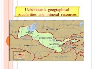
2. Uzbekistan is a country of Central
Asia, located north of Turkmenistan
and Afghanistan. With an area of
447,000 square kilometers
(approximately the size of Spain or
California), Uzbekistan stretches
1,425 km (885 mi) from west to
east and 930 km (580 mi) from
north to south. Bordering
Turkmenistan to the southwest,
Kazakhstan to the north, and
Tajikistan and Kyrgyzstan to the
south and east.
Uzbekistan is not only one of the
larger Central Asian states but also
the only Central Asian state to
border all of the other four.
Uzbekistan also shares a short
border with Afghanistan to the
south. As the Caspian Sea is an
inland sea with no direct link to
the oceans, Uzbekistan is one of
only two "doubly landlocked"
countries—countries completely
surrounded by other landlocked
countries. The other is
Liechtenstein.
4. Uzbekistan’s climate
Uzbekistan's climate is classified as continental, with hot summers and
cool winters. Summer temperatures often surpass 40 °C (104 °F); winter
temperatures average about −2 °C (28 °F), but may fall as low as −40 °C
(−40 °F). Most of the country also is quite arid, with average annual
rainfall amounting to between 100 and 200 millimeters (3.9 and 7.9 in) and
occurring mostly in winter and spring. Between July and September, little
precipitation falls, essentially stopping the growth of vegetation during that
period of time.
5. Mineral resources
The country’s resources include metallic ores; in the
Olmaliq (Almalyk) mining belt in the Kurama Range,
copper, zinc, lead, tungsten, and molybdenum are
extracted. Uzbekistan possesses substantial reserves of
natural gas, oil, and coal. The country consumes large
amounts of its natural gas, and gas pipelines link its
cities and stretch from Bukhara to the Ural region in
Russia as well. Surveys show petroleum resources in the
Fergana Valley (including major reserves in the
Namangan area), in the vicinity of Bukhara, and in
Qoraqalpoghiston. The modern extraction of coal began
to gain importance, especially in the Angren fields, only
during World War II. Hydroelectric dams on the Syr
Darya, the Naryn, and the Chirchiq rivers help augment
the country’s nuclear-, coal-, and petroleum-powered
generation of electricity.
6. Environment of Uzbekistan
The physical environment of Uzbekistan is diverse, ranging from the flat,
desert topography that comprises almost 80% of the country's territory to
mountain peaks in the east reaching about 4,500 metres (14,800 ft) above
sea level. The southeastern portion of Uzbekistan is characterized by the
foothills of the Tian Shan mountains, which rise higher in neighboring
Kyrgyzstan and Tajikistan and form a natural border between Central Asia
and China. The vast Qizilqum (Turkic for "red sand"—Russian spelling Kyzyl
Kum) Desert, shared with southern Kazakhstan, dominates the northern
lowland portion of Uzbekistan. The most fertile part of Uzbekistan, the
Fergana Valley, is an area of about 21,440 square kilometres (8,280 sq mi)
directly east of the Qizilqum and surrounded by mountain ranges to the
north, south, and east. The western end of the valley is defined by the
course of the Syr Darya, which runs across the northeastern sector of
Uzbekistan from southern Kazakhstan into the Qizilqum. Although the
Fergana Valley receives just 100 to 300 millimetres (3.9 to 11.8 in) of rainfall
per year, only small patches of desert remain in the center and along ridges
on the periphery of the valley.
7. Water resources of
Uzbekistan
The Amu Darya The Syr Darya
Water resources, which are unevenly distributed, are in short supply in most of
Uzbekistan. The vast plains that occupy two-thirds of Uzbekistan's territory have little
water, and there are few lakes. The two largest rivers feeding Uzbekistan are the Amu
Darya and the Syr Darya, which originate in the mountains of Tajikistan and Kyrgyzstan,
respectively. These rivers form the two main river basins of Central Asia; they are used
primarily for irrigation, and several artificial canals have been built to expand the supply
of arable land in the Fergana Valley and elsewhere. During the Soviet Era, a plan was
devised in which Kyrgyzstan and Tajikistan provided water from these two rivers to
Kazakhstan, Turkmenistan, and Uzbekistan in summer, and these three countries
provided Kyrgyzstan and Tajikistan with oil and gas during the winter in return. However,
this system dissolved after the collapse of the USSR, and a new resource-sharing plan
has yet to be put in place. According to the International Crisis Group, this situation
could lead to irreparable regional destabilization if it is not resolved. A shallow lake,
Sarygamysh Lake, sits on the border with Turkmenistan.