1. a0057273-3dc7-4775-88c4-8308e1050b16-150918111345-lva1-app6892
S.Zurenko
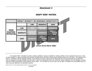
Attachment 2
DRAFT RISK1 MATRIX
IMPACT SEVERITY OR RESOURCE SENSITIVITY
MASS
WASTING
POTENTIAL
LOW MODERATE HIGH
LOW LOW
MODERATE
OR LOW
MODERATE
MODERATE
MODERATE
OR LOW
MODERATE
HIGH or
MODER
ATE
HIGH MODERATE
HIGH or
MODER
ATE
HIGH
version 25.6.6 (March 2005)
1
The assigned “Risk” is intended to provide a relative (qualitative) measure of stability for existing conditions of any proposed harvest area in order
to assist managers in making meaningful and consistent decisions about what kind of forest practice activities should occur and where. The assigned risk or
hazard, in association with the proposed activities, is also intended to assist in determining the appropriate level of assessment that will be performed.
Thus, the assigned risk should ultimately drive the level or scope of the assessment that in turn drives the need for assistance from the geologist as well as
what kind of final documentation will be produced and by whom. It is not meant as a cast in stone rule but rather is intended to be just another tool to be
used to promote deliberate and defendable decisions.
2. a0057273-3dc7-4775-88c4-8308e1050b16-150918111345-lva1-app6892
S.Zurenko
HIGH
HIGH RESOURCE SENSITIVITY
HIGH LIKELIHOOD OF
SEVERE IMPACTS2
and
HIGH MASS WASTING POTENTIAL
GEOLOGIST FIELD VERIFICATION
TRACKING FORM AND
MEMORANDUM OR
FORMAL REPORT3
1) AVOIDANCE
2) LIMITED OPERATIONS ON
SLOPES AFFECTING UNSTABLE
LANDFORMS4
2 The potential to deliver or delivery potential is the relative measure of the likelihood that materials (soil and rock debris, organics including LWD,
SWD) from a landslide will be transported to the area or resource of concern (‘resource at risk’). Thus, delivery potential is typically a major factor in
whether or not impacts will result from a landslide event. The greater the probability of delivery, the more likely it is that impacts (always negative?) will
result. Direct delivery is thought of as the immediate transport of slide materials via the slide event to or through the area or resource of concern and tends
to be more damaging. Indirect delivery is thought of as the eventual transport of slide materials via erosion (typically fluvial) to or through the area or
resource of concern. Although the later can result in substantial negative impacts, the former tends to cause more immediate and often most severe
impacts. Delivery potential is independent of the tendency for a landslide to occur (failure potential).
3 Where resources are particularly sensitive or the potential impact likely to be severe, even when mitigation via avoidance of activities on all
identified unstable landforms is proposed, a brief memorandum to the timber sale file documenting the field verification and avoidance strategy may not
always be adequate to address concerns. Thus, in some cases, we may find it prudent and/or Forest Practices may request that we submit a formal report
as a supporting document.
4 In some cases slopes adjacent to an unstable landform may directly affect or influence conditions of the unstable landform. In those instances
where the activities would cause the influence to be substantially negative, avoidance of activities on those adjacent slopes may be prudent and in other
cases, negative influences may be reduced by mitigation and thus, some limited management may be viable.
3. a0057273-3dc7-4775-88c4-8308e1050b16-150918111345-lva1-app6892
S.Zurenko
HIGH* or
MODE
RATE*
*
HIGH RESOURCE SENSITIVITY
HIGH LIKELIHOOD OF SEVERE IMPACTS 5
and
MODERATE MASS WASTING POTENTIAL
OR
MODERATE RESOURCE SENSITIVITY
MODERATE LIKELIHOOD OF
SEVERE IMPACTS
and
HIGH MASS WASTING POTENTIAL6
*GEOLOGIST FIELD VERIFICATION
OR
**FORESTER’S OPTION TO REQUEST
GEOLOGIST FIELD
VERIFICATION
TRACKING FORM AND
MEMORANDUM OR
FORMAL REPORT7
1) AVOIDANCE
2) LIMITED OPERATIONS ON
SLOPES AFFECTING UNSTABLE
LANDFORMS8
3) OPERATIONS ON SLOPES
AFFECTING UNSTABLE LANDFORMS
5 Generally, a HIGH risk should be assigned when the resource is very sensitive or, because of a high delivery potential, the impacts would likely be
severe. A MODERATE risk could be assigned when the delivery potential is low to negligible and thus, the it would be less likely for severe impacts to
occur. In the former case, field verification by the geologist may be best.
6 When the delivery potential is minimal, then a MODERATE risk may be assigned even with a High mass wasting potential. In these cases,
dependent on the forester’s experience, it may not be necessary to request field verification by the geologist.
7 When the risk is somewhere between HIGH and MODERATE, the avoidance of all identified unstable landforms may be the chosen mitigation. In
such cases, a memorandum to the timber sale file documenting the field verification may be acceptable while in other cases, we may find it prudent and/or
Forest Practices may request that we submit a formal report as a supporting document.
8 See notes on previous page.
4. a0057273-3dc7-4775-88c4-8308e1050b16-150918111345-lva1-app6892
S.Zurenko
MODERATE
HIGH RESOURCE SENSITIVITY
HIGH LIKELIHOOD OF SEVERE
IMPACTS
and
LOW MASS WASTING POTENTIAL9
OR
LOW RESOURCE SENSITIVITY
LOW LIKELIHOOD OF SEVERE
IMPACTS
and
HIGH MASS WASTING POTENTIAL10
OR
MODERATE RESOURCE SENSITIVITY
MODERATE LIKELIHOOD OF
SEVERE IMPACTS
and
MODERATE MASS WASTING
POTENTIAL11
FORESTER’S OPTION TO REQUEST
GEOLOGIST FIELD VERIFICATION12
TRACKING FORM AND
MEMORANDUM OR FORMAL
REPORT
1) LIMITED OPERATIONS ON
SLOPES AFFECTING UNSTABLE
LANDFORMS and/or LIMITED
OPERATIONS ON UNSTABLE
LANDFORMS
2) LIMITED OPERATIONS ON
UNSTABLE LANDFORMS and
OPERATIONS ON SLOPES
AFFECTING UNSTABLE
LANDFORMS 13
3) OPERATIONS ON SLOPES
AFFECTING
UNSTABLE LANDFORMS 14
9
Generally, when the mass wasting potential is LOW, field verification by a geologist need not be requested. However, if the potential to deliver is
fairly high and the resource at risk is sensitive, the LOW mass wasting potential must be weighed against the probability that a slide may reach the
vulnerable resource. Thus, even with a LOW mass wasting potential, there may be reason to request field verification by a geologist.
10 Generally, when the mass wasting potential is HIGH but the resource sensitivity is LOW, field verification by a geologist need not be requested
provided the delivery potential is low.
11 Generally, when the mass wasting potential is MODERATE, the delivery potential is moderate, and the resource at risk involves a mid-level public
safety or critical infrastructure concern or desirable but not unique habitat or a slightly degraded down stream water quality, field verification by a geologist
should still be requested. However, if the potential to deliver to these resources is minimal, then the need for field verification by a geologist may not be
necessary.
12 In order to assure confidence in practice, when the forester’s level of experience is low and/or the area of concern is complex or there is any other
uncertainty, the geologist should be called for field verification.
13 In those cases where the sensitivity of the resource is HIGH, operations on unstable slopes could be proposed when the mass wasting potential is
LOW and the delivery potential is negligible especially if mitigation (besides avoidance) can be applied to avoid increasing the mass wasting potential .
14
7. a0057273-3dc7-4775-88c4-8308e1050b16-150918111345-lva1-app6892
S.Zurenko
*MODERATE15
OR **LOW
MODERATE RESOURCE
SENSITIVITY
MODERATE LIKELIHOOD OF
SEVERE IMPACTS
and
LOW MASS WASTING POTENTIAL
OR
LOW RESOURCE SENSITIVITY
LOW LIKELIHOOD OF
SEVERE IMPACTS
and
MODERATE MASS WASTING
POTENTIAL
*FORESTER’S OPTION TO
REQUEST GEOLOGIST FIELD
VERIFICATION
OR
**FORESTER DELINEATES &
APPLIES16
MITIGATIGATION
TRACKING FORM17
AND/OR
MEMORANDUM
1) OPERATIONS ON UNSTABLE
LANDFORMS and OPERATIONS
ON SLOPES AFFECTING
UNSTABLE LANDFORMS
2) LIMITED OPERATIONS ON
UNSTABLE LANDFORMS and
OPERATIONS ON SLOPES
AFFECTING UNSTABLE
LANDFORMS
3) AVOIDANCE18
15 Generally, a MODERATE risk would be assigned when the mass wasting potential is low and the resource at risk is non-critical but involves public
infrastructure improvements, and public areas or private improvements. When site complexity is minimal, a geologist need not always be called especially if
mitigation is via avoidance of management on potentially unstable slope or unstable landforms
16 Although dependent on forester’s level of experience and site complexity, generally, if the mass wasting potential or the resource sensitivity is
LOW, the assigned risk would be LOW and field verification by a geologist typically would not be needed.
17 Form developed by the Div for tracking our activities on unstable slopes; in anticipation of implementation monitoring of slope protection pursuant
to the HCP, it is recommended that this form be completed for all sales in order to avoid the loss of information and to more efficiently record mitigation
applied (versus waiting till after the fact). If the geologist provides field verification, the form could be the geologist’s responsibility and the forester would
be responsible for the form for sales without geologist involvement in the field.
18 Generally, operations could be proposed on unstable landforms when the assigned risk is LOW or when mass wasting potential is LOW and
mitigation can be applied to avoid increasing the mass wasting potential or, independent of mass wasting, the delivery potential is negligible. However,
8. a0057273-3dc7-4775-88c4-8308e1050b16-150918111345-lva1-app6892
S.Zurenko
LOW
LOW RESOURCE SENSITIVITY
LOW LIKELIHOOD OF SEVERE
IMPACTS
and
LOW MASS WASTING POTENTIAL
FORESTER DELINEATES & APPLIES
MITIGATIGATION
TRACKING FORM19
OPERATIONS ON UNSTABLE
LANDFORMS and OPERATIONS
ON SLOPES AFFECTING
UNSTABLE LANDFORMS20
depending on the delivery potential (and other factors that may be pertinent), operations may be limited or may be prohibited on unstable landforms when
the assigned risk is MODERATE.
19 Form developed by the Div for tracking our activities on unstable slopes. The form is completed for all sales by either the forester or the geologist.
20 Typically, unstable landforms as defined by FP rules are not present when the mass wasting potential is LOW.
9. a0057273-3dc7-4775-88c4-8308e1050b16-150918111345-lva1-app6892
S.Zurenko
SOME SUGGESTED PRACTICLE PARAMETERS:
PLACED TO HELP SEPARATE THE RELATIVE TERMS HIGH, MODERATE, LOW
HIGH MASS WASTING POTENTIAL21
- generally includes, but is not limited to, areas indicated by the
‘hazard’ tools (some are maps) as having a high ‘hazard.’ Examples of the hazard tools we use are soils maps
showing soils assigned a high mass wasting potential (new world) or very unstable when disturbed (old world),
maps showing concentrations of high ‘SLOPSTAB hits’, and landslide inventory maps. Contour or topographic
maps and aerial photos are also screening tools that can help determine where instability may be present. In
addition to areas inferred by the various hazard maps, high mass wasting potential is generally associated with
the unstable landforms as defined by the Forest Practice rules including areas with substantial and cumulative
indicators of potentially unstable slopes, and, obviously, areas with evidence of recent failures or currently
active areas. The various tools, based both on models and empirical evidence, are meant to be used to screen
or identify and prioritize areas with possible instability and it is recognized that not all areas, for example those
mapped with High mass wasting potential or having substantial concentration of high SLOPSTAB ‘hits’, are
actually potentially unstable when field verified. Thus, field verification is necessary to validate or invalidate
the hazards implied by such tools. Delivery potential is independent of mass wasting potential.
21 High, medium, and low potentials are relative. Relative potentials may seem to vary between geographic areas being dependent on the underlying
geology, location in a landscape, and climate. The assigned ‘risk’ or ‘call’ is subjective and thus, the person assigning risk should have experience
identifying unstable landforms in the field and a basic understanding of mass wasting processes..
10. a0057273-3dc7-4775-88c4-8308e1050b16-150918111345-lva1-app6892
S.Zurenko
SOME SUGGESTED PRACTICLE PARAMETERS (continued)
HIGH RESOURCE SENSITIVITY – besides water quality, flow, and stream channel morphology, public
resources include natural and cultural features and values. Some examples are historically or culturally
important places or locations or landforms and built or man-made marks or monuments or structures etc. High
sensitivity would apply to rare (or of concern) animal or plant species or populations and limited, special, and
unique habitat (fish hatcheries?), culturally important places or structures, as well as critical public
improvements, works, or infrastructure such as hospitals, state highways and bridges, sewage treatment
plants, schools, and other public areas receiving high usage or where large numbers of people commonly
gather (malls, stadiums?). Private structures, dwellings, or infrastructure and low use public areas may be
considered of less sensitive but care should be taken to assure all the influencing factors have been considered
and are understood.
HIGH LIKELIHOOD OF SEVERE IMPACTS – very likely that, if a failure occurred, recovery would be slow or
unlikely (long lasting) &/or disturbance would be extensive or physically disruptive and difficult to restore.