More Related Content
Similar to Optimization of Solid Waste Collection and Transportation in Bori Khana LGA Using ArcGIS
Similar to Optimization of Solid Waste Collection and Transportation in Bori Khana LGA Using ArcGIS (20)
Optimization of Solid Waste Collection and Transportation in Bori Khana LGA Using ArcGIS
- 1. !O !O
!O
!O !O !O
!O!O
!O
!O
!O!O !O
!O
!O!O
!O!O
!O
!O
!O
!O
!O!O
!O
!O
!O
!O
!O
!O
!O
!O !O
!O
!O
!O
!O!O
!O
!O
!O
!O
!O!O
!O
!O
!O!O
!O
!O
!O
!O
!O
!O
!O
!O
!O
!O
!O!O
!O
!O
!O
!O
!O
!O
!O
!O
!O !O
!O
!O
!O
!O
!O
!O
!O
!O
!O
!O
!O
§¨¦
§¨¦§¨¦
§¨¦
§¨¦
§¨¦
§¨¦
§¨¦
§¨¦
§¨¦
§¨¦
§¨¦
§¨¦
§¨¦
§¨¦
§¨¦
§¨¦
§¨¦
§¨¦
§¨¦
§¨¦
§¨¦
§¨¦
A
B4
C1
D2
B3
B5
C9
B9
C16
C17
C7
B2
D3
D1
C2
C21
C14
D6
C10
C20
D4
Kanule Street
B16
B18
Market Road
TaabaaRoad
C18
NaalubaStreetB19
Gokana Street
D5
B20
PiagboStreetB1
B15
KaaniRoad
D7
C13
TigidamStreet
Mayor Street C5
D8
TTCRoadB14
C19
CourtRoad
Faith Way
LGACouncilRoad
BoueRoad
Taabaa Road
Prince Igbara Street
PolytechnicRoad
318000.000000
318000.000000
319000.000000
319000.000000
320000.000000
320000.000000
515400.000000
.000000
516100.000000
.000000
516800.000000
.000000
517500.000000
.000000
518200.000000
.000000
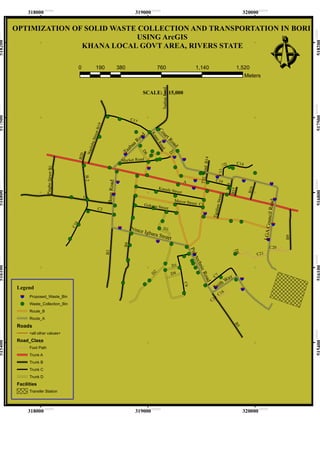
Legend
§¨¦ Proposed_Waste_Bin
!O Waste_Collection_Bin
Route_B
Route_A
Roads
<all other values>
Road_Class
Foot Path
Trunk A
Trunk B
Trunk C
Trunk D
Facilities
Transfer Station
OPTIMIZATION OF SOLID WASTE COLLECTION AND TRANSPORTATION IN BORI
USING ArcGIS
KHANA LOCAL GOVT AREA, RIVERS STATE
Ê0 380 760 1,140 1,520190
Meters
SCALE: 1:15,000