SlideShare a Scribd company logo
1 of 1
Download to read offline
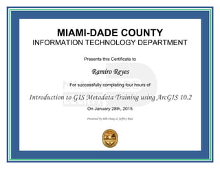
MIAMI-DADE COUNTY
INFORMATION TECHNOLOGY DEPARTMENT
Presents this Certificate to
Ramiro Reyes
For successfully completing four hours of
Introduction to GIS Metadata Training using ArcGIS 10.2
On January 28th, 2015
Presented by Bibi Oung & Jeffrey Ruiz

More Related Content

More from Ramiro Reyes

Characterization of cuban relief using srtm data
Characterization of cuban relief using srtm dataCharacterization of cuban relief using srtm data
Characterization of cuban relief using srtm dataRamiro Reyes
 
Certificate ofcompletion visualizinggeospatialdatawithpowermapinexcel
Certificate ofcompletion visualizinggeospatialdatawithpowermapinexcelCertificate ofcompletion visualizinggeospatialdatawithpowermapinexcel
Certificate ofcompletion visualizinggeospatialdatawithpowermapinexcelRamiro Reyes
 
Certificate ofcompletion htmlessentialtraining
Certificate ofcompletion htmlessentialtrainingCertificate ofcompletion htmlessentialtraining
Certificate ofcompletion htmlessentialtrainingRamiro Reyes
 
Certificate ofcompletion gisontheweb
Certificate ofcompletion gisonthewebCertificate ofcompletion gisontheweb
Certificate ofcompletion gisonthewebRamiro Reyes
 
Certificate ofcompletion excel2013advancedformulasandfunctions
Certificate ofcompletion excel2013advancedformulasandfunctionsCertificate ofcompletion excel2013advancedformulasandfunctions
Certificate ofcompletion excel2013advancedformulasandfunctionsRamiro Reyes
 
Gis apply to distance calculation property vs_gravity main
Gis apply to distance calculation property vs_gravity mainGis apply to distance calculation property vs_gravity main
Gis apply to distance calculation property vs_gravity mainRamiro Reyes
 
Management Planner Refresher(Asbestos)
Management Planner Refresher(Asbestos)Management Planner Refresher(Asbestos)
Management Planner Refresher(Asbestos)Ramiro Reyes
 
Using Geographic Information System to determine priority areas.
Using Geographic Information System to determine priority areas.Using Geographic Information System to determine priority areas.
Using Geographic Information System to determine priority areas.Ramiro Reyes
 

More from Ramiro Reyes (8)

Characterization of cuban relief using srtm data
Characterization of cuban relief using srtm dataCharacterization of cuban relief using srtm data
Characterization of cuban relief using srtm data
 
Certificate ofcompletion visualizinggeospatialdatawithpowermapinexcel
Certificate ofcompletion visualizinggeospatialdatawithpowermapinexcelCertificate ofcompletion visualizinggeospatialdatawithpowermapinexcel
Certificate ofcompletion visualizinggeospatialdatawithpowermapinexcel
 
Certificate ofcompletion htmlessentialtraining
Certificate ofcompletion htmlessentialtrainingCertificate ofcompletion htmlessentialtraining
Certificate ofcompletion htmlessentialtraining
 
Certificate ofcompletion gisontheweb
Certificate ofcompletion gisonthewebCertificate ofcompletion gisontheweb
Certificate ofcompletion gisontheweb
 
Certificate ofcompletion excel2013advancedformulasandfunctions
Certificate ofcompletion excel2013advancedformulasandfunctionsCertificate ofcompletion excel2013advancedformulasandfunctions
Certificate ofcompletion excel2013advancedformulasandfunctions
 
Gis apply to distance calculation property vs_gravity main
Gis apply to distance calculation property vs_gravity mainGis apply to distance calculation property vs_gravity main
Gis apply to distance calculation property vs_gravity main
 
Management Planner Refresher(Asbestos)
Management Planner Refresher(Asbestos)Management Planner Refresher(Asbestos)
Management Planner Refresher(Asbestos)
 
Using Geographic Information System to determine priority areas.
Using Geographic Information System to determine priority areas.Using Geographic Information System to determine priority areas.
Using Geographic Information System to determine priority areas.
 

Ramiro Reyes metadata

  • 1. MIAMI-DADE COUNTY INFORMATION TECHNOLOGY DEPARTMENT Presents this Certificate to Ramiro Reyes For successfully completing four hours of Introduction to GIS Metadata Training using ArcGIS 10.2 On January 28th, 2015 Presented by Bibi Oung & Jeffrey Ruiz