
Recommended
More Related Content
What's hot
What's hot (18)
Similar to NostalgicOutdoors™- Olympic National Park Guide- Dosewallips Area Hiking
Similar to NostalgicOutdoors™- Olympic National Park Guide- Dosewallips Area Hiking (20)
More from NostalgicOutdoors™
More from NostalgicOutdoors™ (20)
Recently uploaded
Recently uploaded (20)
NostalgicOutdoors™- Olympic National Park Guide- Dosewallips Area Hiking
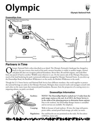
- 1. Dosewallips Information Facilities: NOTE!! The Dosewallips Road is washed out 5.5 miles from the park ranger station at the end. As of 2013, the Forest Service is in the midst of the planning process to determine future options. Due to the washout, the Dosewallips Ranger Station is unstaffed and no services are available. No telephone. Camping: Walk-in because of road washout. 30 sites, fire rings with grates, picnic tables, animal-proof food storage, pit toilet, no water. Regulations: Pets and bicycles are not permitted on the trails. No fires above 3,500 feet, stoves only. Dosewallips Area Partners in Time O lympic National Park is often described as an island. The Olympic Peninsula's landscape has changed so much in the past century that much of the park's western boundary is visible in satellite images. Animal and plant life does not recognize political boundaries. Rivers flow, elk and fish migrate, and seeds blow from one parcel of land to another. Wildlife exists wherever it can. On the eastern side of the Olympic Mountains, much of the land bordering the park is protected wilderness managed by Olympic National Forest. As you drive up the Dosewallips Road, the Buckhorn Wilderness is to the north, the Brothers Wilderness to the south. Though the U.S. Forest Service and National Park Service have different mandates, they work together to protect the national heritage set aside on the Olympic Peninsula. Biologists share research results and managers consult with each other on the many issues that transcend park boundaries. Because, from the perspective of a soaring raven or a migrating salmon, no park is an island. North Climbing route to Lake Constance Dosewallips Ranger Station Walk-in Sites 0 0 2000 feet 0.6 km ConstanceCreek Dosewallips River OlympicNationalPark OlympicNationalForest To 101 Dosewallips Road Terrace Loop Trail To Hayden Pass, Constance Pass or Anderson Pass Dosewallips Falls Road closed at boundary in winter Stock Facility Olympic Olympic National Park
- 2. Forest Sentinels The spotted owl is famous. Listed as threatened under the Endan- gered Species Act in 1990, it soon made the news more than any other animal in the Northwest. For some, the bird is a symbol of economic hardship because of its association with reduced logging in the region's productive forests. To others its presence indicates the health and integrity of primeval forest ecosystems. But really, the owl is just going about the daily business of survival. Spotted owls need the physical structure provided by old growth forests. They need low limbs to stay cool on warm days and high limbs to keep warm on cool days. They need these forests to provide them with enough food, like flying squirrels and voles. While some may hunt among younger trees, spotted owls will only nest in large stretches of old forests. If an owl pair cannot find a patch of forest big enough and far enough away from another nesting pair, they simply will not nest that year. If that keeps happening, their population will continue to decrease. Here in Olympic National Park, the spotted owl has found a last stronghold against development that steadily encroaches on its territory. There are more nesting pairs in these dry eastern forests than anywhere else on the Peninsula. But even in the park, spotted owls face threats like displacement by more aggressive barred owls. Only time will reveal if the spotted owl's haunting call will continue to echo among the park's ancient trees, a small voice for a vast wilderness that cannot speak in its own defense. Hikes Around Dosewallips (Road washout adds 5.5 miles to trail mileages below.) Terrace Loop: Easy 1.2 mile loop through forested terraces above the Dosewallips River. Elevation gain 200 feet. Lake Constance: This very steep climbing route is difficult (see box to right) and is not recommended for children. Constance Pass: 7.5 miles, with 3,368 feet elevation gain one way to the pass. This is a strenuous climb into Olympic's high country. West Fork 10.5 miles to Anderson Pass, 2,864 foot elevation Dosewallips: gain from lowland forest to mountain meadows. Main Fork 14.9 miles to Hayden Pass, 4,250 foot elevation Dosewallips: gain, or walk the fairly level 1.4 miles to a bridge at Dose Forks. 5/13 What A Climb! The climbing route to Lake Constance is short, but steep. It gains 3,300 feet in just two miles! The route is often in a rocky, slippery stream bed, and involves scrambling on rocks and hand- over-hand climbing. Remember that Lake Constance is a no-fire zone and a quota area for overnight stays. There are only six campsites, and you must obtain a wilderness permit before camping there. See www.nps.gov/olym for more information from our Wilderness Information Center on permits, reservations and food storage. We need your help to maintain the wild solitude campers search for.