SlideShare a Scribd company logo
1 of 1
Download to read offline
VARSITY 
NOSE HILL PARK 
RANCHLANDS 
SIGNAL HILL 
10 ST NW 
HIGHWOOD 
54 AV NW 
27 AV NW 
BUCKTHORN RD NW 
EAU CLAIRE 
BELTLINE 
CALGARY INTERNATIONAL AIRPORT 
McCALL 
BOWNESS 
DALHOUSIE 
8A ST NE 
REGAL CR NE 
RENFREW 
THORNCLIFFE 
WILDWOOD 
DALKEITH HL NW 
BRENNER DR NW 
BRENTWOOD 
MONTGOMERY 
VISTA HEIGHTS 
BRIDGELAND/RIVERSIDE 
INGLEWOOD 
COLLINGWOOD 
CORNWALLIS DR NW 
HILLHURST 
HUNTINGTON HILLS 
EDGEMONT 
SILVER SPRINGS 
ST. ANDREWS HEIGHTS 
25 AV NW 
RICHMOND 
15 AV SW 
GLENBROOK 
PATTERSON 
ALYTH/BONNYBROOK 
WEST HILLHURST 
GLENDALE 
HIGHFIELD 
9 ST NW 
7 AV SW 
ELBOW PARK 
06B 
RAMSAY 
STRATHCONA PARK 
2 AV NW 
ALTADORE 
SHAGANAPPI 
BANFF TRAIL 
MAYLAND 
UNIVERSITY OF CALGARY 
CAPITOL HILL 
34 ST NW 
WESTGATE SUNALTA 
MOUNT PLEASANT 
SOUTH AIRWAYS 
PARKDALE 
MAYLAND HEIGHTS 
35 AV NE 
33 AV NE 
27 AV NE 
26 AV NE 
25 AV NE 
WINSTON HEIGHTS/MOUNTVIEW 
COACH HILL SUNNYSIDE 
54 AV NE 
HIGHLAND PARK 
DOVER 
SPRUCE CLIFF 
ROSSCARROCK 
MISSION 
BANKVIEW 
NORTH AIRWAYS 
ROSEDALE 
CHRISTIE PARK 
14 AV SW 
CFB - CURRIE 
PARKHILL 
SCARBORO 
33 AV SW 
GLAMORGAN 
PEGASUS 
8 AV NE 
45 ST SW 
9 AV SE 
20 AV NW 
37 ST SW 
12 AV SW 
4 ST SW 
13 AV SW 
19 ST NW 
19 AV NW 
18 AV NW 
26 ST SW 
17 AV NW 
1 ST SE 
JOHN LAURIE BV NW 
4 ST NE 
MEMORIAL DR NW 
33 ST SW 
5 AV NW 
16 AV NE 
27 ST SW 
22 AV NW 
19 ST NE 
2 ST NE 
30 AV SW 
25 ST SW 
29 AV SW 
10 ST NW 
30 AV N W 
31 AV SW 
25A ST SW 
32 AV SW 
14 ST NW 
8 AV SE 
9 ST SE 
4 ST NW 
6 ST NE 
24 AV NW 
SARCEE TR SW 
3 AV SW 
38 AV SW 
21 AV NW 
NORTHMOUNT DR NW 
12 ST SW 
CAPRI AV NW 
28 ST SW 
TAXI RD NE 
27 AV SW 
16 AV SW 
69 ST SW 
38 ST SW 
30 ST SW 
20 ST SW 
31 ST SW 
32 ST SW 
28 AV SW 
35 ST SW 
VARSITY DR NW 
18 AV NE 
15 AV NE 
14 AV NE 
13 AV N E 
53 ST NW 
21 AV NE 
6 AV SE 
7 AV SE 
15 ST NW 
26 AV NW 
34 ST SW 
36 ST SW 
21 ST SW 
24 AV NE 
11 ST NE 
28 AV NW 
11 AV SE 
17 AV SE 
5 AV SW 
32 AV NW 
30 AV NE 
41 ST SW 
11 AV NE 
6 ST SE 
SARCEE TR W 
12 AV NE 
23 AV NE 
22 AV NE 
40 ST SW 
73 ST NW 
29 AV NW 
25 AV SW 
36 AV NE 
OGDE N RD SE 
KENSINGTON RD NW 
9 AV NE 
8 ST SE 
29 ST NW 
MORLEY TR NW 
MACLEOD TR S 
52 ST NW 
4 ST SE 
78 AV NE 
37 AV NE 
49 ST SW 
7 AV NE 
MACKAY RD NW 
3 AV NW 
24A ST SW 
2 ST NW 
1 ST NW 
MACLEOD TR SE 
4 AV NW 
33 AV SW 
10 AV NE 
7 ST SE 
20 AV NE 
22 ST NW 
BOW TR SW 
32 AV NE 
52 AV NW 
6 ST SW 
46 ST NW 
42 ST SW 
12 AV NW 
67 ST NW 
23 AV NW 
CRESCENT RD NW 
DEERFOOT TR SE 
SHAGANAPPI TR NW 
16 ST NW 
69 ST NW 
SARCEE TR NW 
12 ST NW 
12 ST NE 
BRISEBOIS DR NW 
7A ST NW 
34 AV SE 
49 ST NW 
10 AV SE 
11 AV NW 
CROWCHILD TR NW 
19 AV NE 
24 ST NW 
64 AV NW 
25 ST NW 
45 AV NE 
70 ST NW 
AERO RD NE 
3 ST NW 
9 ST NW 
48 ST NW 
2 AV NE 
24 AV SW 
16 ST SW 
19 ST SW 
72 AV NW 
9 ST NE 
DALHART RD NW 
BROADVIEW RD NW 
38 AV SE 
1A ST SW 
ALYTH RD SE 
68 AV N W 
28 AV NE 
45 ST NW 
35 ST NW 
41 AV NE 
13 AV NW 
43 ST SW 
SILVER SPRINGS BV NW 
34 AV NE 
37 ST NW 
BOW CR NW 
42 ST NW 
MCKINNON DR NE 
BOWWOOD DR NW 
CENTRE AV E 
40 AV NW 
60 AV NE 
SIROCCO DR SW 
36 AV NW 
3 ST SE 
WESTWOOD DR SW 
7A ST NE 
47 ST SW 
14 AV SW 
31 AV N W 
BLACKFOOT TR SE 
15A ST SW 
34 AV SW 
11 AV SW 
NORTH HAVEN DR NW 
37 AV NW 
10 AV SW 
SIFTON BV SW 
BULYEA RD NW 
HIGHFIELD RD SE 
13 ST SW 
HUNTERVIEW DR NW 
SARCEE RD SW 
WINDERMERE RD SW 
GROVE HILL RD SW 
65 AV NE 
29 AV N E 
4 AV NE 
55 AV NE 
4 AV SE 
CONRAD DR NW 
3 ST NE 
AERO DR NE 
36 AV SE 
57 AV NE 
73 ST SW 
44 ST NW 
HUNTRIDGE HL NE 
17 AV SW 
68 AV NE 
54 AV NW 
21 ST NW 
CROWCHILD TR SW 
47 ST NW 
17A ST NE 
66 AV NW 
18 ST SE 
31 AV NE 
PROSPECT AV SW 
11 ST SE 
WILDWOOD DR SW 
RENFREW DR NE 
MEMORIAL DR NE 
39 ST SW 
9 ST SW 
18 AV SW 
29 ST SW 
26 ST NW 
72 ST NW 
5 AV SE 
16 ST NE 
23 ST NW 
DALHOUSIE DR NW 
12 AV SE 
10 ST NE 
9A ST NE 
8A ST NE 
34 ST NW 
16 AV NW 
SPILLER RD SE 
68 ST NW 
34 AV NW 
ST GEORGES DR NE 
SIGNAL HILL HT SW 
26 AV SW 
20A ST NW 
7 AV SW 
7 ST NW 
SIGNAL HILL DR SW 
MCKNIGHT BV NE 
32 ST NW 
TRELLE DR NE 
11 ST NW 
CAYUGA DR NW 
28 ST NW 
THORNCLIFFE DR NW 
1 AV NE 
PATINA DR SW 
SPRUCE DR SW 
EDWORTHY ST SW 
5 ST SE 
20 ST NW 
9A ST NW 
14 ST NE 
53 AV NE 
6 AV NE 
2 ST SW 
11A ST NW 
63 ST NW 
ERLTON ST SW 
HOLLAND ST NW 
22 AV SW 
NORFOLK DR NW 
MCCALL WY NE 
7 ST SW 
44 AV NE 
58 ST NW 
5 ST NE 
17 ST NW 
24 ST SW 
MCDOUGALL RD NE 
23 AV SE 
8 AV SW 
5 ST NW 
SCARBORO AV SW 
40 AV NE 
17 AV NE 
9 AV NW 
5 AV NE 
DALTON DR NW BAROC RD NW 
RIVERFRONT AV SE 
21 AV SE 
MCKNIGHT BV NW 
STAMPEDE TR SE 
ELMONT DR SW 
56 AV NE 
14 ST SE 
SKYLINE WY NE 
11A ST SE 
COCHRANE RD NW 
SILVER SPRINGS GA NW 
43 ST NW 
39 AV SE 
HOME RD NW 
40 AV SW 
17A ST SW 
NORTHLAND DR NW 
22A ST NW 
BOULTON RD NW 
DEERFOOT TR NE 
35 AV SW 
39 AV NW 
64 AV NE 
ZOO RD NE 
CARNEY RD NW 
KELWOOD DR SW 
6 ST NW 
15A ST NE 
22 ST SW 
54 ST NW 
CENTRE B ST NW 
6 AV SW 
TACHE AV NW 
3 AV NE 
10A ST NW 
UNDERHILL DR NW 
WESTVIEW DR SW 
HENDON DR NW 
16A ST SE 
10 AV NW 
CANMORE RD NW 
REMINGTON RD NE 
24 AV S E 
TORONTO CR NW 
19 AV SW 
63 AV NW 
50 ST NW 
43 AV NW 
NORQUAY DR NW 
31 ST NW 
DRURY AV NE 
4A ST NW 
HOCHWALD AV SW 
35A ST NW 
44 AV NW 
15 AV SW 
8 ST NE 
3 ST SW 
11A ST NE 
18 ST NW 
VAL IANT DR NW 
38A AV SE 
SAIT WY NW 
SILVERGROVE DR NW 
RIDEAU RD SW 
20 AV SE 
13 AV SE 
THORNHILL DR NW 
13A ST SW 
CAPITOL HILL CR NW 
7 AV NW 
CENTRE AV NE 
WINTER HT SW 
32 AV SE 
6 AV NW 
1 AV NW 
CAMPUS DR NW 
BOWNESS RD NW 
14 AV NW 
51 ST SW 
41 AV NW 
40 ST NW 
CENTRE AV SW 
AVIATION RD NE 
WAVERLEY DR SW 
39 ST NW 
13 ST NW 
CLIFF ST SW 
CENTRE ST N 
POPLAR RD SW 
RICHMOND RD SW 
HARLOW AV NW 
8 ST NW 
15 ST NE 
26 AV SE 
BRENTWOOD RD NW 
4 AV SW 
THORNTON RD NW 
15 ST SE 
VARSITY ESTATES DR NW 
UXBRIDGE DR NW 
GODDARD AV NE 
TRAFFORD DR NW 
15A ST SE 
1 ST SW 
18 AV SE 
21A ST NW 
8 AV NW 
46 AV NE 
6A ST NE 
72 AV N E 
ELKTON DR SW 
36 ST NW 
WINSTON DR SW 
13 ST NE 
NEW ST SE 
10 ST SE 
36 AV SW 
CAMERON AV SW 
34A ST NW 
ROSEHILL DR NW 
23 ST NE 
19 ST SE 
38A AV S W 
16A ST NW 
SPYHILL RD NW 
GREENVIEW DR NE 
18A ST NE 
18 ST SW 
AIR SIDE LI NE 
VIENNA DR NW 
39 AV SW 
19 AV SE 
23 ST SW 
12 ST SE 
MEMORIAL DR SE 
BRIAR CR NW 
ELBOW DR SW 
COLERIDGE RD NW 
DALGETTY DR NW 
BATTLEFORD AV SW 
CHAPEL RD NW 
18 ST NE 
14A ST SW 
51 ST NW 
COACH HILL RD SW 
MERE DITH RD NE 
23 AV SW 
MUNRO DR NE 
WESTMOUNT BV NW 
25 AV SE 
NING A RD NW 
44 ST SW 
75 AV N W 
WOLFE ST SW 
SILVERVIEW RD NW 
MAGGIE ST SE 
ELVEDEN DR SW 
BLACKTHORN RD NE 
71 ST NW 
8 ST SW 
UNIVERSITY DR NW 
17 ST SE 
16 ST SE 
16A ST SW 
CHILD AV NE 
EDGEMONT RD NW 
BLACKTHORN RD NW 
PATTERSON DR SW 
HUNTERBURN HL NW 
BRECKEN RD NW 
TRANS CANADA HI W 
MONCTON RD NE 
14 ST SW 
CLARET ST NW 
33 ST NW 
DALCASTLE DR NW 
HOUNSLOW DR NW 
21 AV SW 
VIMY WY SW 
VARSITY ESTATES RI NW 
MONTALBAN DR NW 
HUNTERHORN DR NE 
HIGHFIELD BV SE 
THORNABY WY NW 
DALMENY HL NW 
COUNCIL WY SW 
10 ST SW 
BRENTWOOD GR NW 
56 AV NW 
PORTLAND ST SE 
41 AV SE 
BARR RD NW 
BOWDALE CR NW 
58 ST SW 
26A ST SW 
PALMER RD NE 
KERRYDALE RD SW 
HARTFORD RD NW 
GARRISON BV SW 
RUSSELL RD NE 
35 AV NW 
33 AV N W 
SIENNA PARK DR SW 
BONNYBROOK RD SE 
PACIFIC RD NE 
OLYMPIC WY SE 
23A ST NW 
ROSERY DR NW 
17A ST NW 
NORRIS RD NW 
DALHURST WY NW 
SOMME AV SW 
GRAHAM DR SW 
22 AV SE 
HALIFAX CR NW 
ADELAIDE ST SE 
BENTON DR NW 
GLENWOOD DR SW 
VICEROY DR NW 
SILVER SPRINGS DR NW 
EDGEHILL DR NW 
UTAH DR NW 
WORCESTER DR SW 
5 ST SW 
1 ST NE 
48 AV NW 
7 ST NE 
41 ST NW 
3A ST NE 
HAWTHORN DR NW 
VARMOOR RD NW 
3 AV SE 
11 ST SW 
SPRINGBOROUGH BV SW 
CHILDREN'S WY NW 
37 AV SW 
BURNSLAND RD SE 
2A ST NW 
DURHAM AV SW 
ROSELAWN CR NW 
13A ST NE 
41 AV SW 
DALM EAD CR NW 
VARL EY DR NW 
WALNUT DR SW 
2 AV SW 
CHELSEA ST NW 
17 ST SW 
20 AV SW 
WEST SPRINGS RD SW 
SANCTUARY RD SE 
48 AV NE 
BANFF TR NW 
CENTRE A ST NE 
WINSLOW CR SW 
SIGNAL HILL CI SW 
14A ST SE 
EDGEMONT BV NW 
BEAVER DAM RD NE 
RIVERDALE AV SW 
MEOTA RD NE 
21 ST NE 
DALHOUSIE RD NW 
BEIL AV NW 
14 AV SE 
CANYON DR NW 
50 ST SW 
39 AV NE 
38 AV NE 
KILKENNY RD SW 
DANLOE ST NE 
THORNBRIAR RD NW 
43 AV NE 
POINT DR NW 
15 ST SW 
CENTRE ST S 
VARAL RD NW 
WESTOVER DR SW 
24A ST NW 
15 AV NW 
2A ST SE 
VEGAS RD NW 
VARDELL RD NW 
1A ST NW 
DORCHESTER AV SW 
BEAVER RD NW 
COACH MANOR RI SW 
UNGAVA RD NW 
NOLAN RD NW 
WATERLOO DR SW 
NAMAKA CR NW 
SALISBURY ST SE 
48 ST SW 
PATRICK VW SW 
SIMC OE RD SW 
SIMCREST MR SW 
42 AV NE 
BARRON DR NW 
BAKER CR NW 
FOWLER DR NW 
HUNTS CR NW 
42 AV NW 
4A ST NE 
GLADYS RID GE RD SW 
19A ST SW 
18A ST NW 
JOLIET AV SW 
SUFFOLK ST SW 
PATRICK ST SW 
74 ST NW 
22 ST NE 
VOYAGEUR DR NW 
ULSTER RD NW 
20A AV NE 
53 AV NW 
PUMPHOUSE RD SW 
GRAND OAKS DR SW 
30 ST NW 
VISTA RD NE 
CADOGAN RD NW 
17A ST SE 
SAMIS RD NE 
NESBITT RD NW 
SIMCOE GA SW 
ROSS RD NW 
RIDGE RD SW 
AVIATION PL NE 
COULEE LN SW 
CREEK RD NE 
CARTIER ST SW 
12A ST NE 
35A ST SW 
PARK LN SW 
22 ST SE 
HUNTLEY WY NE 
STRATHRIDGE CL SW 
8A AV NE 
5A ST NW 
SHARON AV SW 
VIRGINIA DR NW 
CELTIC RD NW 
RANCHVIEW CI NW 
VINCENT PL NW 
SILVER BROOK WY NW 
32 AV NW 
35 AV NW 
5 ST NW 
14A ST SW 
22A ST NW 
9 ST SE 
11 AV NW 
1 ST NW 
6 ST SW 
19 AV NW 
9 ST NW 
16 ST SW 
9 ST SW 
22 AV NW 
3 AV SE 
34 AV SW 
24 AV NE 
22 AV NW 
34 AV S W 
31 AV NW 
16 AV NE 
10 ST NE 
4 ST NE 
25 AV SW 
35 AV SW 
23 AV NW 
30 AV SW 
7 AV NW 
BOWNESS RD NW 
5 ST NE 
12 AV SW 
3 AV SW 
32 AV SW 
18 AV NW 
15A ST SE34 AV SW 
31 ST SW 
6 AV NW 
24 ST NW 
19 AV NW 
8 AV SE 
37 AV NW 
12 AV SW 
8 AV SW 
27 AV SW 
37 AV SW 
18A ST NW 
28 AV SW 
18 ST NE 
5 AV NE 
12 ST SW 
33 ST SW 
2 ST NW 
22 ST NE 
13 ST NW 
30 AV NE 
40 AV NW 
MACLEOD TR S 
1 ST NW 
21 AV SW 
17 AV SE 
11 ST NW 
6 ST NW 
DEERFOOT TR SE 
25 AV NW 
9 ST SW 
40 AV NE 
5 ST NW 
7 AV NW 
15 ST SW 
73 ST SW 
9 ST NE 
17A ST NW 
14 AV NW 
3 AV NE 3 AV NE 
15 ST SW 
18 ST NW 
27 AV NE 
70 ST NW 
50 ST NW 
5 AV NW 
5 ST NE 
34 AV SE 
15 ST NE 
34 AV S W 
6 ST NE 
21 ST NE 
5 ST SE 
10 AV NW 
21 AV SW 
4A ST NW 
26 AV SW 
7 AV NW 
1 ST NE 
21 ST NE 
11 ST NE 
15 AV NW 
38 ST SW 
16 AV SW 
4A ST NW 
13 AV SW 
1 AV NE 
8 AV SW 
8 ST NE 
16 ST SW 
5 AV SW 
40 AV NE 
15 AV NW 
15 ST SE 
26A ST SW 
28 ST SW 
14 AV NE 
15 ST NE 
29 ST SW 
38 AV NE 
6 ST SW 
6 ST NE 
5A ST NW 
12 AV NW 
1 ST NE 
26 AV SE 
21 AV NW 
69 ST NW 
31 AV SW 
50 ST NW 
29 AV SW 
34 AV SW 
6 AV NW 
44 AV NW 
19 AV SW 
11 ST NW 
38 ST SW 
6 AV NW 
22 ST SW 
17 AV SE 
20 AV SW 
2 AV SW 
23 AV NW 
12 AV NE 
16 ST SW 
16 ST SE 
20 ST NW 
10 AV SW 
2 ST NW 
41 AV SE 
10 ST NE 
3 AV NW 
6 ST NE 
20 AV NW 
23 ST NW 
1 ST NE 
11A ST NE 
19 AV SW 
42 AV NE 
25 AV NE 
42 ST SW 
23 AV NW 
4A ST NE 
26 AV NW 
1 ST NW 
14 ST NE 
8 AV NW 
35 AV NE 
14 AV SW 
10 ST SW 
30 AV NE 
17 ST SW 
9 ST NE 
5 AV NE 
13 AV NW 
BOWNESS RD NW 
16 AV N W 
12 AV SW 
13 ST SW 
22 AV SE 
SARCEE TR SW 
5 AV NW 
10 ST NE 
38 ST SW 
6 ST NW 
3 ST SW 
16 ST SW 
8 ST NW 
17 ST SW 
5 AV SW 
40 ST SW 
5 AV SW 
SPILLER RD SE 
7 ST SW 
11 ST NE 
4 ST NW 
24 ST SW 
6A ST NE 
24 AV NW 
35 AV SW 
36 AV NW 
22 AV NE 
7 ST NW 
19 ST NE 
36 ST SW 
18 AV SW 
33 ST NW 
11 AV SW 
15 AV SW 
25 AV NE 
24 ST NW 
39 AV NE 
42 ST SW 
31 AV NW 
33 AV SW 
23 ST NW 
AERO RD NE 
DEERFOOT TR NE 
47 ST SW 
CROWCHILD TR NW 
2 ST NE 
BOWNESS RD NW 
18 AV NE 
8 AV NW 
36 AV NE 
3 ST NW 
16 ST NW 
30 AV SW 
17 AV NW 
32 AV NW 
39 ST NW 
3 ST NW 
13 AV NW 
35 AV SW 
16 ST SE 
17 AV NE 
39 AV SW 
7 ST SE 
32 AV NW 
16 ST NE 
26 AV SW 
5 ST NW 
23 ST NE 
32 AV NW 
7 AV NW 
22 AV SW 
11 ST SE 
7 AV NE 
11 ST NE 
1 AV NW 
69 ST SW 
7 ST SW 
7 AV SE 
22 ST NW 
4 AV NW 
7 ST NW 
6 AV NW 
25 AV SW 
1 ST NW 
9 AV NW 
34 AV N W 
7 ST SW 
20 ST NW 
1 ST NW 
19 AV SW 
30 AV SW 
2 ST SW 
12 ST NW 
15 ST SW 
7 ST NW 
3 ST NW 
8 ST NE 
5 ST NE 
8 ST NW 
4 AV NE 
22 ST NW 
18 AV SW 
64 AV NE 
4 ST NE 
23 ST SW 
15 ST NW 
8 ST NE 
8 AV NW 
6 ST NE 
15 ST SE 
36 ST NW 
68 AV NE 
10 AV SW 
32 AV SW 
SARCEE TR W 
10 AV NE 
40 AV SW 
10 AV SE 
3 AV NW 
3 ST NE 
6 ST SE 
18 AV SE 
9 AV NW 
31 AV NE 
17A ST SW 
34 AV S W 
17 ST SE 
8 AV SW 
1 ST NE 
23 AV SW 
16 ST NW 
9 AV NW 
36 AV SW 
4 ST NE 
34 AV SE 
23 ST NW 
21 ST NW 
2 ST SW 
14 AV SW 
Source: Esri, DigitalGlobe, GeoEye, i-cubed, USDA, USGS, AEX, Getmapping, Aerogrid, IGN, IGP, swisstopo, and the GIS User Community 
LEGEND 
Bike Paths - Ice Unlikely 
Bike Paths - Ice Probable 
Bike Paths - Ice Likely 
Streets 
River 
Park 
Community Boundary 
BBii cc yy cc ll ee PPaa tthh WWiinntt ee rr II cc ee HHaa zz aa rrdd LL oo cc aa tt iioonn ss 
ffoo rr CCaa llgg aa rr yy '' ss CCii tt yy CCeenn tt rr ee 
Kilometers 
± 0 1 2 4 
Coordinate System: Calgary 3TM WGS 1984 W114 
Projection: Transverse Mercator 
Datum: WGS 1984 
Author: Mark Schimnowsky 
Date: February 11, 2014 
Mapped Area 
Kilometers 
± 0 3 6 12 
Warning: 
It 
is 
possible 
for 
any 
of 
Calgary’s 
bike 
paths 
to 
develop 
ice 
buildup 
at 
any 
given 
;me 
throughout 
the 
winter 
and 
its 
shoulder 
seasons. 
This 
map 
should 
be 
only 
used 
as 
a 
guide. 
Efficiently 
connec,ng 
people 
and 
places 
by 
providing 
mobility 
and 
accessibility 
is 
the 
number 
one 
goal 
and 
priority 
of 
Calgary 
Transit. 
Promo,ng 
easy 
bike 
access 
to 
transit 
sta,ons 
helps 
to 
make 
public 
transit 
more 
accessible 
and 
increase 
ridership. 
Unfortunately, 
many 
ci,zens 
who 
access 
transit 
sta,ons 
by 
bike 
during 
the 
summer 
months 
do 
not 
feel 
safe 
or 
comfortable 
during 
Calgary’s 
winter 
months 
since 
icy 
bike 
paths 
present 
a 
cycling 
hazard. 
In 
order 
to 
encourage 
and 
promote 
winter 
cycling 
in 
the 
City 
of 
Calgary, 
this 
map 
iden,fies 
sec,ons 
of 
bike 
paths 
that 
are 
more 
suscep,ble 
to 
ice 
buildup 
than 
others 
throughout 
the 
most 
frequent 
cycling 
areas 
in 
the 
centre 
of 
Calgary, 
including 
downtown, 
and 
the 
University 
of 
Calgary’s 
main 
campus 
in 
the 
northwest. 
While 
it 
is 
possible 
for 
all 
bike 
paths 
to 
develop 
ice 
buildup 
during 
Calgary’s 
winter 
months, 
it 
is 
possible 
to 
iden,fy 
areas 
where 
the 
hazard 
is 
a 
greater 
risk. 
Bike 
paths 
that 
are 
situated 
on 
north 
facing 
slopes 
are 
considered 
the 
most 
suscep,ble 
to 
ice 
buildup 
as 
they 
receive 
very 
liHle 
or 
no 
sunlight 
during 
the 
winter 
months, 
so 
ice 
buildup 
is 
considered 
likely. 
Bike 
paths 
situated 
on 
northwest 
and 
northeast 
facing 
slopes 
are 
also 
suscep,ble 
as 
they 
receive 
liHle 
sunlight, 
so 
ice 
buildup 
is 
considered 
probable. 
All 
remaining 
bike 
paths 
(situated 
on 
east, 
southeast, 
south, 
southwest, 
and 
west 
slopes) 
are 
the 
least 
likely 
to 
have 
ice 
accumulate, 
so 
they 
are 
considered 
unlikely 
to 
have 
ice 
buildup. 
In 
order 
to 
determine 
which 
bike 
paths 
are 
situated 
on 
north, 
and 
northwest 
or 
northeast 
facing 
slopes, 
a 
Digital 
Eleva,on 
Model 
(DEM) 
was 
used 
to 
calculate 
slope, 
and 
slope 
aspect 
of 
the 
bike 
paths 
in 
the 
City 
of 
Calgary. 
A 
slope 
aspect 
between 
337.5⁰-­‐22.5⁰ 
was 
classified 
as 
facing 
north 
(with 
0⁰ 
being 
due 
north), 
a 
slope 
aspect 
between 
22.5⁰-­‐67.5⁰ 
was 
classified 
as 
facing 
northeast, 
and 
a 
slope 
aspect 
between 
292.5⁰-­‐337.5⁰ 
was 
classified 
as 
facing 
northwest. 
A 
slope 
aspect 
between 
67.5⁰-­‐292.5⁰ 
was 
classified 
as 
all 
other 
aspects. 
The 
bike 
paths 
facing 
north 
are 
assigned 
the 
colour 
red 
where 
ice 
is 
likely, 
bike 
paths 
facing 
northwest 
or 
northeast 
are 
assigned 
the 
colour 
yellow 
where 
ice 
is 
probable, 
and 
bike 
paths 
facing 
all 
other 
aspects 
are 
assigned 
the 
colour 
green, 
where 
ice 
is 
unlikely. 
With 
help 
from 
this 
map, 
cyclists 
may 
be 
able 
to 
beHer 
navigate 
the 
bike 
paths 
during 
winter. 
NW# 
N# 
NE# 
S# 
E# 
W# 
SW# SE# 
This 
compass 
wheel 
shows 
the 
delinea,on 
of 
slope 
aspects 
used 
to 
determine 
the 
likeliness 
of 
ice 
on 
city 
bike 
paths.

More Related Content

Viewers also liked

Viewers also liked (20)

Esquema del plan tutorial de aula
Esquema del plan tutorial de aulaEsquema del plan tutorial de aula
Esquema del plan tutorial de aula
 
EJEMPLO DE MÉTODO CIENTÍFICO Y FLUJOGRAMA
EJEMPLO DE MÉTODO CIENTÍFICO Y FLUJOGRAMAEJEMPLO DE MÉTODO CIENTÍFICO Y FLUJOGRAMA
EJEMPLO DE MÉTODO CIENTÍFICO Y FLUJOGRAMA
 
Webs
WebsWebs
Webs
 
Panduan
PanduanPanduan
Panduan
 
Dan Bannino
Dan BanninoDan Bannino
Dan Bannino
 
Fredison
FredisonFredison
Fredison
 
Alpha
AlphaAlpha
Alpha
 
01 laporan akhir kajian pelaksanaan spm kabupaten nagan raya a
01 laporan akhir kajian pelaksanaan spm kabupaten nagan raya a01 laporan akhir kajian pelaksanaan spm kabupaten nagan raya a
01 laporan akhir kajian pelaksanaan spm kabupaten nagan raya a
 
Anamariapinzon
AnamariapinzonAnamariapinzon
Anamariapinzon
 
Presentación de celda virtual Robotcell / virtual cell using robotcell
Presentación de celda virtual Robotcell / virtual cell using robotcellPresentación de celda virtual Robotcell / virtual cell using robotcell
Presentación de celda virtual Robotcell / virtual cell using robotcell
 
Salud tabla
Salud tablaSalud tabla
Salud tabla
 
Sesión 15 américa latina contemporánea
Sesión 15 américa latina contemporáneaSesión 15 américa latina contemporánea
Sesión 15 américa latina contemporánea
 
Reinauguracao Cachoeirinha
Reinauguracao CachoeirinhaReinauguracao Cachoeirinha
Reinauguracao Cachoeirinha
 
Sesiones 1 ro
Sesiones 1 roSesiones 1 ro
Sesiones 1 ro
 
Resume
ResumeResume
Resume
 
58 multi brand
58 multi brand58 multi brand
58 multi brand
 
Test
TestTest
Test
 
Tourette Sendromu Nedir? Bekir Berker Artukoğlu
Tourette Sendromu Nedir? Bekir Berker ArtukoğluTourette Sendromu Nedir? Bekir Berker Artukoğlu
Tourette Sendromu Nedir? Bekir Berker Artukoğlu
 
Seminario saludysegocup
Seminario saludysegocupSeminario saludysegocup
Seminario saludysegocup
 
Tp2
Tp2Tp2
Tp2
 

Similar to Calgary Neighborhood Map: Over 150 Areas

Joplin Neighborhoods Color by Name
Joplin Neighborhoods Color by NameJoplin Neighborhoods Color by Name
Joplin Neighborhoods Color by NameStephen Grindle
 
Save Your Do GymWrap Walmart Store Locations
Save Your Do GymWrap Walmart Store LocationsSave Your Do GymWrap Walmart Store Locations
Save Your Do GymWrap Walmart Store LocationsSaveYourDo
 
Main street program 092016
Main street program 092016Main street program 092016
Main street program 092016Brendan O'Connor
 
Scott Phinney - Portland City Center
Scott Phinney - Portland City CenterScott Phinney - Portland City Center
Scott Phinney - Portland City CenterScott Phinney
 
Duke Energy of Ohio Proposed Routes for NatGas Pipeline in Hamilton County, OH
Duke Energy of Ohio Proposed Routes for NatGas Pipeline in Hamilton County, OHDuke Energy of Ohio Proposed Routes for NatGas Pipeline in Hamilton County, OH
Duke Energy of Ohio Proposed Routes for NatGas Pipeline in Hamilton County, OHMarcellus Drilling News
 
UITSLAGEN-2015-Tour-Shorthanded-en-Marina-Monnickendam
UITSLAGEN-2015-Tour-Shorthanded-en-Marina-MonnickendamUITSLAGEN-2015-Tour-Shorthanded-en-Marina-Monnickendam
UITSLAGEN-2015-Tour-Shorthanded-en-Marina-MonnickendamEddo Rats
 
Dallas 555 map book
Dallas 555 map bookDallas 555 map book
Dallas 555 map bookKeri Aroesty
 

Similar to Calgary Neighborhood Map: Over 150 Areas (19)

2015 zoning map with arial
2015 zoning map with arial2015 zoning map with arial
2015 zoning map with arial
 
Joplin Neighborhoods Color by Name
Joplin Neighborhoods Color by NameJoplin Neighborhoods Color by Name
Joplin Neighborhoods Color by Name
 
Bike_ped_Woodcock_McHenry
Bike_ped_Woodcock_McHenryBike_ped_Woodcock_McHenry
Bike_ped_Woodcock_McHenry
 
allpoints
allpointsallpoints
allpoints
 
Busbkln
BusbklnBusbkln
Busbkln
 
Garland Recycling Schedule map
Garland Recycling Schedule mapGarland Recycling Schedule map
Garland Recycling Schedule map
 
Game Day Parking & Traffic Routes
Game Day Parking & Traffic RoutesGame Day Parking & Traffic Routes
Game Day Parking & Traffic Routes
 
Save Your Do GymWrap Walmart Store Locations
Save Your Do GymWrap Walmart Store LocationsSave Your Do GymWrap Walmart Store Locations
Save Your Do GymWrap Walmart Store Locations
 
CNI MAPS Attch 21 062416
CNI MAPS Attch 21 062416CNI MAPS Attch 21 062416
CNI MAPS Attch 21 062416
 
Main street program 092016
Main street program 092016Main street program 092016
Main street program 092016
 
Busqns
BusqnsBusqns
Busqns
 
Cd12 8.5 11
Cd12 8.5 11Cd12 8.5 11
Cd12 8.5 11
 
Scott Phinney - Portland City Center
Scott Phinney - Portland City CenterScott Phinney - Portland City Center
Scott Phinney - Portland City Center
 
Duke Energy of Ohio Proposed Routes for NatGas Pipeline in Hamilton County, OH
Duke Energy of Ohio Proposed Routes for NatGas Pipeline in Hamilton County, OHDuke Energy of Ohio Proposed Routes for NatGas Pipeline in Hamilton County, OH
Duke Energy of Ohio Proposed Routes for NatGas Pipeline in Hamilton County, OH
 
Doepke_Park_Layout_121715
Doepke_Park_Layout_121715Doepke_Park_Layout_121715
Doepke_Park_Layout_121715
 
Round one award bep
Round one award bepRound one award bep
Round one award bep
 
Location map
Location mapLocation map
Location map
 
UITSLAGEN-2015-Tour-Shorthanded-en-Marina-Monnickendam
UITSLAGEN-2015-Tour-Shorthanded-en-Marina-MonnickendamUITSLAGEN-2015-Tour-Shorthanded-en-Marina-Monnickendam
UITSLAGEN-2015-Tour-Shorthanded-en-Marina-Monnickendam
 
Dallas 555 map book
Dallas 555 map bookDallas 555 map book
Dallas 555 map book
 

Calgary Neighborhood Map: Over 150 Areas

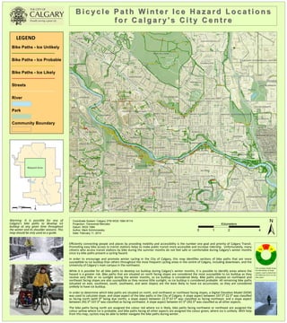
  • 1. VARSITY NOSE HILL PARK RANCHLANDS SIGNAL HILL 10 ST NW HIGHWOOD 54 AV NW 27 AV NW BUCKTHORN RD NW EAU CLAIRE BELTLINE CALGARY INTERNATIONAL AIRPORT McCALL BOWNESS DALHOUSIE 8A ST NE REGAL CR NE RENFREW THORNCLIFFE WILDWOOD DALKEITH HL NW BRENNER DR NW BRENTWOOD MONTGOMERY VISTA HEIGHTS BRIDGELAND/RIVERSIDE INGLEWOOD COLLINGWOOD CORNWALLIS DR NW HILLHURST HUNTINGTON HILLS EDGEMONT SILVER SPRINGS ST. ANDREWS HEIGHTS 25 AV NW RICHMOND 15 AV SW GLENBROOK PATTERSON ALYTH/BONNYBROOK WEST HILLHURST GLENDALE HIGHFIELD 9 ST NW 7 AV SW ELBOW PARK 06B RAMSAY STRATHCONA PARK 2 AV NW ALTADORE SHAGANAPPI BANFF TRAIL MAYLAND UNIVERSITY OF CALGARY CAPITOL HILL 34 ST NW WESTGATE SUNALTA MOUNT PLEASANT SOUTH AIRWAYS PARKDALE MAYLAND HEIGHTS 35 AV NE 33 AV NE 27 AV NE 26 AV NE 25 AV NE WINSTON HEIGHTS/MOUNTVIEW COACH HILL SUNNYSIDE 54 AV NE HIGHLAND PARK DOVER SPRUCE CLIFF ROSSCARROCK MISSION BANKVIEW NORTH AIRWAYS ROSEDALE CHRISTIE PARK 14 AV SW CFB - CURRIE PARKHILL SCARBORO 33 AV SW GLAMORGAN PEGASUS 8 AV NE 45 ST SW 9 AV SE 20 AV NW 37 ST SW 12 AV SW 4 ST SW 13 AV SW 19 ST NW 19 AV NW 18 AV NW 26 ST SW 17 AV NW 1 ST SE JOHN LAURIE BV NW 4 ST NE MEMORIAL DR NW 33 ST SW 5 AV NW 16 AV NE 27 ST SW 22 AV NW 19 ST NE 2 ST NE 30 AV SW 25 ST SW 29 AV SW 10 ST NW 30 AV N W 31 AV SW 25A ST SW 32 AV SW 14 ST NW 8 AV SE 9 ST SE 4 ST NW 6 ST NE 24 AV NW SARCEE TR SW 3 AV SW 38 AV SW 21 AV NW NORTHMOUNT DR NW 12 ST SW CAPRI AV NW 28 ST SW TAXI RD NE 27 AV SW 16 AV SW 69 ST SW 38 ST SW 30 ST SW 20 ST SW 31 ST SW 32 ST SW 28 AV SW 35 ST SW VARSITY DR NW 18 AV NE 15 AV NE 14 AV NE 13 AV N E 53 ST NW 21 AV NE 6 AV SE 7 AV SE 15 ST NW 26 AV NW 34 ST SW 36 ST SW 21 ST SW 24 AV NE 11 ST NE 28 AV NW 11 AV SE 17 AV SE 5 AV SW 32 AV NW 30 AV NE 41 ST SW 11 AV NE 6 ST SE SARCEE TR W 12 AV NE 23 AV NE 22 AV NE 40 ST SW 73 ST NW 29 AV NW 25 AV SW 36 AV NE OGDE N RD SE KENSINGTON RD NW 9 AV NE 8 ST SE 29 ST NW MORLEY TR NW MACLEOD TR S 52 ST NW 4 ST SE 78 AV NE 37 AV NE 49 ST SW 7 AV NE MACKAY RD NW 3 AV NW 24A ST SW 2 ST NW 1 ST NW MACLEOD TR SE 4 AV NW 33 AV SW 10 AV NE 7 ST SE 20 AV NE 22 ST NW BOW TR SW 32 AV NE 52 AV NW 6 ST SW 46 ST NW 42 ST SW 12 AV NW 67 ST NW 23 AV NW CRESCENT RD NW DEERFOOT TR SE SHAGANAPPI TR NW 16 ST NW 69 ST NW SARCEE TR NW 12 ST NW 12 ST NE BRISEBOIS DR NW 7A ST NW 34 AV SE 49 ST NW 10 AV SE 11 AV NW CROWCHILD TR NW 19 AV NE 24 ST NW 64 AV NW 25 ST NW 45 AV NE 70 ST NW AERO RD NE 3 ST NW 9 ST NW 48 ST NW 2 AV NE 24 AV SW 16 ST SW 19 ST SW 72 AV NW 9 ST NE DALHART RD NW BROADVIEW RD NW 38 AV SE 1A ST SW ALYTH RD SE 68 AV N W 28 AV NE 45 ST NW 35 ST NW 41 AV NE 13 AV NW 43 ST SW SILVER SPRINGS BV NW 34 AV NE 37 ST NW BOW CR NW 42 ST NW MCKINNON DR NE BOWWOOD DR NW CENTRE AV E 40 AV NW 60 AV NE SIROCCO DR SW 36 AV NW 3 ST SE WESTWOOD DR SW 7A ST NE 47 ST SW 14 AV SW 31 AV N W BLACKFOOT TR SE 15A ST SW 34 AV SW 11 AV SW NORTH HAVEN DR NW 37 AV NW 10 AV SW SIFTON BV SW BULYEA RD NW HIGHFIELD RD SE 13 ST SW HUNTERVIEW DR NW SARCEE RD SW WINDERMERE RD SW GROVE HILL RD SW 65 AV NE 29 AV N E 4 AV NE 55 AV NE 4 AV SE CONRAD DR NW 3 ST NE AERO DR NE 36 AV SE 57 AV NE 73 ST SW 44 ST NW HUNTRIDGE HL NE 17 AV SW 68 AV NE 54 AV NW 21 ST NW CROWCHILD TR SW 47 ST NW 17A ST NE 66 AV NW 18 ST SE 31 AV NE PROSPECT AV SW 11 ST SE WILDWOOD DR SW RENFREW DR NE MEMORIAL DR NE 39 ST SW 9 ST SW 18 AV SW 29 ST SW 26 ST NW 72 ST NW 5 AV SE 16 ST NE 23 ST NW DALHOUSIE DR NW 12 AV SE 10 ST NE 9A ST NE 8A ST NE 34 ST NW 16 AV NW SPILLER RD SE 68 ST NW 34 AV NW ST GEORGES DR NE SIGNAL HILL HT SW 26 AV SW 20A ST NW 7 AV SW 7 ST NW SIGNAL HILL DR SW MCKNIGHT BV NE 32 ST NW TRELLE DR NE 11 ST NW CAYUGA DR NW 28 ST NW THORNCLIFFE DR NW 1 AV NE PATINA DR SW SPRUCE DR SW EDWORTHY ST SW 5 ST SE 20 ST NW 9A ST NW 14 ST NE 53 AV NE 6 AV NE 2 ST SW 11A ST NW 63 ST NW ERLTON ST SW HOLLAND ST NW 22 AV SW NORFOLK DR NW MCCALL WY NE 7 ST SW 44 AV NE 58 ST NW 5 ST NE 17 ST NW 24 ST SW MCDOUGALL RD NE 23 AV SE 8 AV SW 5 ST NW SCARBORO AV SW 40 AV NE 17 AV NE 9 AV NW 5 AV NE DALTON DR NW BAROC RD NW RIVERFRONT AV SE 21 AV SE MCKNIGHT BV NW STAMPEDE TR SE ELMONT DR SW 56 AV NE 14 ST SE SKYLINE WY NE 11A ST SE COCHRANE RD NW SILVER SPRINGS GA NW 43 ST NW 39 AV SE HOME RD NW 40 AV SW 17A ST SW NORTHLAND DR NW 22A ST NW BOULTON RD NW DEERFOOT TR NE 35 AV SW 39 AV NW 64 AV NE ZOO RD NE CARNEY RD NW KELWOOD DR SW 6 ST NW 15A ST NE 22 ST SW 54 ST NW CENTRE B ST NW 6 AV SW TACHE AV NW 3 AV NE 10A ST NW UNDERHILL DR NW WESTVIEW DR SW HENDON DR NW 16A ST SE 10 AV NW CANMORE RD NW REMINGTON RD NE 24 AV S E TORONTO CR NW 19 AV SW 63 AV NW 50 ST NW 43 AV NW NORQUAY DR NW 31 ST NW DRURY AV NE 4A ST NW HOCHWALD AV SW 35A ST NW 44 AV NW 15 AV SW 8 ST NE 3 ST SW 11A ST NE 18 ST NW VAL IANT DR NW 38A AV SE SAIT WY NW SILVERGROVE DR NW RIDEAU RD SW 20 AV SE 13 AV SE THORNHILL DR NW 13A ST SW CAPITOL HILL CR NW 7 AV NW CENTRE AV NE WINTER HT SW 32 AV SE 6 AV NW 1 AV NW CAMPUS DR NW BOWNESS RD NW 14 AV NW 51 ST SW 41 AV NW 40 ST NW CENTRE AV SW AVIATION RD NE WAVERLEY DR SW 39 ST NW 13 ST NW CLIFF ST SW CENTRE ST N POPLAR RD SW RICHMOND RD SW HARLOW AV NW 8 ST NW 15 ST NE 26 AV SE BRENTWOOD RD NW 4 AV SW THORNTON RD NW 15 ST SE VARSITY ESTATES DR NW UXBRIDGE DR NW GODDARD AV NE TRAFFORD DR NW 15A ST SE 1 ST SW 18 AV SE 21A ST NW 8 AV NW 46 AV NE 6A ST NE 72 AV N E ELKTON DR SW 36 ST NW WINSTON DR SW 13 ST NE NEW ST SE 10 ST SE 36 AV SW CAMERON AV SW 34A ST NW ROSEHILL DR NW 23 ST NE 19 ST SE 38A AV S W 16A ST NW SPYHILL RD NW GREENVIEW DR NE 18A ST NE 18 ST SW AIR SIDE LI NE VIENNA DR NW 39 AV SW 19 AV SE 23 ST SW 12 ST SE MEMORIAL DR SE BRIAR CR NW ELBOW DR SW COLERIDGE RD NW DALGETTY DR NW BATTLEFORD AV SW CHAPEL RD NW 18 ST NE 14A ST SW 51 ST NW COACH HILL RD SW MERE DITH RD NE 23 AV SW MUNRO DR NE WESTMOUNT BV NW 25 AV SE NING A RD NW 44 ST SW 75 AV N W WOLFE ST SW SILVERVIEW RD NW MAGGIE ST SE ELVEDEN DR SW BLACKTHORN RD NE 71 ST NW 8 ST SW UNIVERSITY DR NW 17 ST SE 16 ST SE 16A ST SW CHILD AV NE EDGEMONT RD NW BLACKTHORN RD NW PATTERSON DR SW HUNTERBURN HL NW BRECKEN RD NW TRANS CANADA HI W MONCTON RD NE 14 ST SW CLARET ST NW 33 ST NW DALCASTLE DR NW HOUNSLOW DR NW 21 AV SW VIMY WY SW VARSITY ESTATES RI NW MONTALBAN DR NW HUNTERHORN DR NE HIGHFIELD BV SE THORNABY WY NW DALMENY HL NW COUNCIL WY SW 10 ST SW BRENTWOOD GR NW 56 AV NW PORTLAND ST SE 41 AV SE BARR RD NW BOWDALE CR NW 58 ST SW 26A ST SW PALMER RD NE KERRYDALE RD SW HARTFORD RD NW GARRISON BV SW RUSSELL RD NE 35 AV NW 33 AV N W SIENNA PARK DR SW BONNYBROOK RD SE PACIFIC RD NE OLYMPIC WY SE 23A ST NW ROSERY DR NW 17A ST NW NORRIS RD NW DALHURST WY NW SOMME AV SW GRAHAM DR SW 22 AV SE HALIFAX CR NW ADELAIDE ST SE BENTON DR NW GLENWOOD DR SW VICEROY DR NW SILVER SPRINGS DR NW EDGEHILL DR NW UTAH DR NW WORCESTER DR SW 5 ST SW 1 ST NE 48 AV NW 7 ST NE 41 ST NW 3A ST NE HAWTHORN DR NW VARMOOR RD NW 3 AV SE 11 ST SW SPRINGBOROUGH BV SW CHILDREN'S WY NW 37 AV SW BURNSLAND RD SE 2A ST NW DURHAM AV SW ROSELAWN CR NW 13A ST NE 41 AV SW DALM EAD CR NW VARL EY DR NW WALNUT DR SW 2 AV SW CHELSEA ST NW 17 ST SW 20 AV SW WEST SPRINGS RD SW SANCTUARY RD SE 48 AV NE BANFF TR NW CENTRE A ST NE WINSLOW CR SW SIGNAL HILL CI SW 14A ST SE EDGEMONT BV NW BEAVER DAM RD NE RIVERDALE AV SW MEOTA RD NE 21 ST NE DALHOUSIE RD NW BEIL AV NW 14 AV SE CANYON DR NW 50 ST SW 39 AV NE 38 AV NE KILKENNY RD SW DANLOE ST NE THORNBRIAR RD NW 43 AV NE POINT DR NW 15 ST SW CENTRE ST S VARAL RD NW WESTOVER DR SW 24A ST NW 15 AV NW 2A ST SE VEGAS RD NW VARDELL RD NW 1A ST NW DORCHESTER AV SW BEAVER RD NW COACH MANOR RI SW UNGAVA RD NW NOLAN RD NW WATERLOO DR SW NAMAKA CR NW SALISBURY ST SE 48 ST SW PATRICK VW SW SIMC OE RD SW SIMCREST MR SW 42 AV NE BARRON DR NW BAKER CR NW FOWLER DR NW HUNTS CR NW 42 AV NW 4A ST NE GLADYS RID GE RD SW 19A ST SW 18A ST NW JOLIET AV SW SUFFOLK ST SW PATRICK ST SW 74 ST NW 22 ST NE VOYAGEUR DR NW ULSTER RD NW 20A AV NE 53 AV NW PUMPHOUSE RD SW GRAND OAKS DR SW 30 ST NW VISTA RD NE CADOGAN RD NW 17A ST SE SAMIS RD NE NESBITT RD NW SIMCOE GA SW ROSS RD NW RIDGE RD SW AVIATION PL NE COULEE LN SW CREEK RD NE CARTIER ST SW 12A ST NE 35A ST SW PARK LN SW 22 ST SE HUNTLEY WY NE STRATHRIDGE CL SW 8A AV NE 5A ST NW SHARON AV SW VIRGINIA DR NW CELTIC RD NW RANCHVIEW CI NW VINCENT PL NW SILVER BROOK WY NW 32 AV NW 35 AV NW 5 ST NW 14A ST SW 22A ST NW 9 ST SE 11 AV NW 1 ST NW 6 ST SW 19 AV NW 9 ST NW 16 ST SW 9 ST SW 22 AV NW 3 AV SE 34 AV SW 24 AV NE 22 AV NW 34 AV S W 31 AV NW 16 AV NE 10 ST NE 4 ST NE 25 AV SW 35 AV SW 23 AV NW 30 AV SW 7 AV NW BOWNESS RD NW 5 ST NE 12 AV SW 3 AV SW 32 AV SW 18 AV NW 15A ST SE34 AV SW 31 ST SW 6 AV NW 24 ST NW 19 AV NW 8 AV SE 37 AV NW 12 AV SW 8 AV SW 27 AV SW 37 AV SW 18A ST NW 28 AV SW 18 ST NE 5 AV NE 12 ST SW 33 ST SW 2 ST NW 22 ST NE 13 ST NW 30 AV NE 40 AV NW MACLEOD TR S 1 ST NW 21 AV SW 17 AV SE 11 ST NW 6 ST NW DEERFOOT TR SE 25 AV NW 9 ST SW 40 AV NE 5 ST NW 7 AV NW 15 ST SW 73 ST SW 9 ST NE 17A ST NW 14 AV NW 3 AV NE 3 AV NE 15 ST SW 18 ST NW 27 AV NE 70 ST NW 50 ST NW 5 AV NW 5 ST NE 34 AV SE 15 ST NE 34 AV S W 6 ST NE 21 ST NE 5 ST SE 10 AV NW 21 AV SW 4A ST NW 26 AV SW 7 AV NW 1 ST NE 21 ST NE 11 ST NE 15 AV NW 38 ST SW 16 AV SW 4A ST NW 13 AV SW 1 AV NE 8 AV SW 8 ST NE 16 ST SW 5 AV SW 40 AV NE 15 AV NW 15 ST SE 26A ST SW 28 ST SW 14 AV NE 15 ST NE 29 ST SW 38 AV NE 6 ST SW 6 ST NE 5A ST NW 12 AV NW 1 ST NE 26 AV SE 21 AV NW 69 ST NW 31 AV SW 50 ST NW 29 AV SW 34 AV SW 6 AV NW 44 AV NW 19 AV SW 11 ST NW 38 ST SW 6 AV NW 22 ST SW 17 AV SE 20 AV SW 2 AV SW 23 AV NW 12 AV NE 16 ST SW 16 ST SE 20 ST NW 10 AV SW 2 ST NW 41 AV SE 10 ST NE 3 AV NW 6 ST NE 20 AV NW 23 ST NW 1 ST NE 11A ST NE 19 AV SW 42 AV NE 25 AV NE 42 ST SW 23 AV NW 4A ST NE 26 AV NW 1 ST NW 14 ST NE 8 AV NW 35 AV NE 14 AV SW 10 ST SW 30 AV NE 17 ST SW 9 ST NE 5 AV NE 13 AV NW BOWNESS RD NW 16 AV N W 12 AV SW 13 ST SW 22 AV SE SARCEE TR SW 5 AV NW 10 ST NE 38 ST SW 6 ST NW 3 ST SW 16 ST SW 8 ST NW 17 ST SW 5 AV SW 40 ST SW 5 AV SW SPILLER RD SE 7 ST SW 11 ST NE 4 ST NW 24 ST SW 6A ST NE 24 AV NW 35 AV SW 36 AV NW 22 AV NE 7 ST NW 19 ST NE 36 ST SW 18 AV SW 33 ST NW 11 AV SW 15 AV SW 25 AV NE 24 ST NW 39 AV NE 42 ST SW 31 AV NW 33 AV SW 23 ST NW AERO RD NE DEERFOOT TR NE 47 ST SW CROWCHILD TR NW 2 ST NE BOWNESS RD NW 18 AV NE 8 AV NW 36 AV NE 3 ST NW 16 ST NW 30 AV SW 17 AV NW 32 AV NW 39 ST NW 3 ST NW 13 AV NW 35 AV SW 16 ST SE 17 AV NE 39 AV SW 7 ST SE 32 AV NW 16 ST NE 26 AV SW 5 ST NW 23 ST NE 32 AV NW 7 AV NW 22 AV SW 11 ST SE 7 AV NE 11 ST NE 1 AV NW 69 ST SW 7 ST SW 7 AV SE 22 ST NW 4 AV NW 7 ST NW 6 AV NW 25 AV SW 1 ST NW 9 AV NW 34 AV N W 7 ST SW 20 ST NW 1 ST NW 19 AV SW 30 AV SW 2 ST SW 12 ST NW 15 ST SW 7 ST NW 3 ST NW 8 ST NE 5 ST NE 8 ST NW 4 AV NE 22 ST NW 18 AV SW 64 AV NE 4 ST NE 23 ST SW 15 ST NW 8 ST NE 8 AV NW 6 ST NE 15 ST SE 36 ST NW 68 AV NE 10 AV SW 32 AV SW SARCEE TR W 10 AV NE 40 AV SW 10 AV SE 3 AV NW 3 ST NE 6 ST SE 18 AV SE 9 AV NW 31 AV NE 17A ST SW 34 AV S W 17 ST SE 8 AV SW 1 ST NE 23 AV SW 16 ST NW 9 AV NW 36 AV SW 4 ST NE 34 AV SE 23 ST NW 21 ST NW 2 ST SW 14 AV SW Source: Esri, DigitalGlobe, GeoEye, i-cubed, USDA, USGS, AEX, Getmapping, Aerogrid, IGN, IGP, swisstopo, and the GIS User Community LEGEND Bike Paths - Ice Unlikely Bike Paths - Ice Probable Bike Paths - Ice Likely Streets River Park Community Boundary BBii cc yy cc ll ee PPaa tthh WWiinntt ee rr II cc ee HHaa zz aa rrdd LL oo cc aa tt iioonn ss ffoo rr CCaa llgg aa rr yy '' ss CCii tt yy CCeenn tt rr ee Kilometers ± 0 1 2 4 Coordinate System: Calgary 3TM WGS 1984 W114 Projection: Transverse Mercator Datum: WGS 1984 Author: Mark Schimnowsky Date: February 11, 2014 Mapped Area Kilometers ± 0 3 6 12 Warning: It is possible for any of Calgary’s bike paths to develop ice buildup at any given ;me throughout the winter and its shoulder seasons. This map should be only used as a guide. Efficiently connec,ng people and places by providing mobility and accessibility is the number one goal and priority of Calgary Transit. Promo,ng easy bike access to transit sta,ons helps to make public transit more accessible and increase ridership. Unfortunately, many ci,zens who access transit sta,ons by bike during the summer months do not feel safe or comfortable during Calgary’s winter months since icy bike paths present a cycling hazard. In order to encourage and promote winter cycling in the City of Calgary, this map iden,fies sec,ons of bike paths that are more suscep,ble to ice buildup than others throughout the most frequent cycling areas in the centre of Calgary, including downtown, and the University of Calgary’s main campus in the northwest. While it is possible for all bike paths to develop ice buildup during Calgary’s winter months, it is possible to iden,fy areas where the hazard is a greater risk. Bike paths that are situated on north facing slopes are considered the most suscep,ble to ice buildup as they receive very liHle or no sunlight during the winter months, so ice buildup is considered likely. Bike paths situated on northwest and northeast facing slopes are also suscep,ble as they receive liHle sunlight, so ice buildup is considered probable. All remaining bike paths (situated on east, southeast, south, southwest, and west slopes) are the least likely to have ice accumulate, so they are considered unlikely to have ice buildup. In order to determine which bike paths are situated on north, and northwest or northeast facing slopes, a Digital Eleva,on Model (DEM) was used to calculate slope, and slope aspect of the bike paths in the City of Calgary. A slope aspect between 337.5⁰-­‐22.5⁰ was classified as facing north (with 0⁰ being due north), a slope aspect between 22.5⁰-­‐67.5⁰ was classified as facing northeast, and a slope aspect between 292.5⁰-­‐337.5⁰ was classified as facing northwest. A slope aspect between 67.5⁰-­‐292.5⁰ was classified as all other aspects. The bike paths facing north are assigned the colour red where ice is likely, bike paths facing northwest or northeast are assigned the colour yellow where ice is probable, and bike paths facing all other aspects are assigned the colour green, where ice is unlikely. With help from this map, cyclists may be able to beHer navigate the bike paths during winter. NW# N# NE# S# E# W# SW# SE# This compass wheel shows the delinea,on of slope aspects used to determine the likeliness of ice on city bike paths.