El constructivismo y el conductismo en la educación, características diferenc...
JAllen_User_Showcase_2014
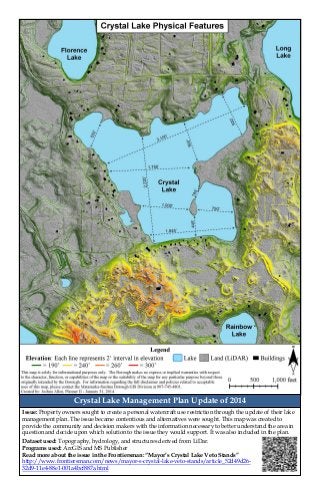
1. Crystal Lake Management Plan Update of 2014
Dataset used: Topography, hydrology, and structures derived from LiDar.
Programs used: ArcGIS and MS Publisher
Read more about the issue in the Frontiersman: “Mayor’s Crystal Lake Veto Stands”
http://www.frontiersman.com/news/mayor-s-crystal-lake-veto-stands/article_52d49d26-
32d9-11e4-88e1-001a4bcf887a.html
Issue: Property owners sought to create a personal watercraft use restriction through the update of their lake
management plan. The issue became contentious and alternatives were sought. This map was created to
provide the community and decision makers with the information necessary to better understand the area in
question and decide upon which solution to the issue they would support. It was also included in the plan.