SlideShare a Scribd company logo
1 of 1
Download to read offline
Country Club Estates is bounded by the Florida Turnpike on the West,
441 on the East, Broward Boulevard on the North, and Peters Road to
the South. Approximately half of the neighborhood is residential; sin-
gle family homes and one apartment complex. The other half is a 36
hole private golf course and country club.
The residents enjoy their suburban lifestyle, and although they cannot
use the golf course, they appreciate its impact on the neighborhood.
81Chapter 6:Thoroughfare Designs for Walkable Urban Areas
places in Europe and the United States, and the chal-
lenges of the intersections have been addressed in many
ways. The traditional design of multiway boulevard in-
tersections is to provide stop control for the access lanes
and signalized or stop control for the cross-streets and
central roadway (see Figure 6.8). In urban areas, the
access lanes are often controlled with traffic signals and
sometimes restrict selected movements from both the
central roadway and the access lanes. Common traffic
control and operational configurations for traditional
multiway boulevard intersections are described in Ta-
ble 6.6 and illustrated in Figure 6.9.
Alternative Multiway Intersection Designs
Thoroughfare designers have developed a number of
alternatives to the traditional multiway boulevard in-
tersection. These alternatives include:
• Access road slip ramps prior to and after intersec-
tions to provide conventional four-leg intersections;
• Forced right turns from the access lane to the
cross-street. Where turning movements are re-
stricted, cross-streets should be part of a well-con-
nected grid of streets so vehicles leaving the access
lanes can easily return to the central roadway;
• Access lanes diverted away from the central
roadway at cross streets increase separation and
reduce the complexity of the intersection. This
design concept significantly affects the place-
ment of buildings at intersection corners; and
• Access lanes beginning just past an intersection
(either with or without a lane drop), and end-
ing with or without a lane addition just before
an adjacent intersection, similar to the design of
frontage roads.
All of the above alternatives disrupt the continuity of
the access lane along the length of the boulevard. This
is an important factor in considering local circulation,
particularly if the access lanes provide for bicycle trav-
el along the corridor.
Design Examples
The following design examples provide a brief synop-
sis of the design process, illustrating some of the key
steps in developing and evaluating solutions to thor-
oughfare design problems. The examples do not rep-
resent all of the possible combinations but do show
some common thoroughfare situations. The four ex-
amples respectively illustrate the following thorough-
fare design scenarios:
1. Creation of a retail-oriented and pedestrian-
friendly main street collector avenue;
Figure 6.8 This multiway boulevard provides stop control for the low-volume, low-speed access lanes. The central
roadway is controlled by a traffic signal. Source: Kimley-Horn and Associates, Inc.
79Chapter 6:Thoroughfare Designs for Walkable Urban Areas
Property should be accessed from cross-streets or
alleys, although access lanes may be intersected
by local streets or consolidated driveways without
direct access to the central roadway. Access lanes
provide on-street parking that may be associated
with curb extensions at intersections or extensions
that contain street trees. The width of access lanes
is composed of the parking lane (7 to 8 feet) and
a shared travel lane (10 to 11 feet). Some fire de-
partments may require wider access lanes. How-
ever, for emergency access purposes, buildings may
be able to be accessed from the central roadway.
The maximum width of an access lane should be
17 feet with parking on one side and 24 feet with
parking on both sides.
• Median islands—raised medians are used to sepa-
rate the access lanes from the central roadway. The
width of these medians varies because they may
serve multiple functions. At a minimum, the me-
dian contains landscaping, including trees, street-
lights, traffic signs and other utilities. On transit
streets, the medians accommodate bus stops or
stations. On multiway boulevards with very wide
medians, sidewalks, seating and other urban de-
sign features may be provided. Medians may be
designed with mountable curbs and load-bearing
surfaces on the access lane side to accommodate
emergency vehicles. Median breaks are provided
on some traditional multiway boulevards to allow
vehicles into the access lane and entry back into
the central roadway where turn movements are re-
stricted at the intersections.
• Streetside—provides a highly pedestrian-ori-
ented environment and access to building en-
trances. On residential boulevards, the streetside
emphasizes planting strips or tree wells and pe-
destrian-scaled lighting. On commercial boule-
vards, the streetside is designed to accommodate
the activities of the adjacent ground floor uses,
emphasizing wide furnishing zones for street
trees, seating, urban design features and street
cafes. See Chapter 8 for details on the streetside.
General Cross-Section Design Parameters and
Right-of-Way Requirements
Because of their multiple components, the multiway
boulevard typically has greater right-of-way require-
ments than other types of boulevards. Although street-
side and median widths can vary substantially, the mini-
mum right of way for a basic four-lane multiway bou-
levard is 104 feet, composed of the following elements
(see Figure 6.6):
• 9-foot-wide streetsides;
Figure 6.6 A multiway boulevard is characterized by a central roadway with a pair of one-way access lanes. This type of
thoroughfare can combine high vehicular capacity with pedestrian-friendly streetsides. Source: Digital Media Productions.
Provide Pedestrian/Bi-
cycle connections at exist-
ing dead ends to improve
walkability and connectivity,
by creating openings in the
walls.
Convert vacant land into
additional park space with
features such as:
•skate parks
•basketball courts
•sports fields
•exercise path equipment
Develop commercial areas with high density,
mixed use developments with low setbacks:
Develop vacant land
Redevelop poorly utilized commercial ar-
eas
Open key golf course paths
to public pedestrian and bi-
cycle use in order to provide
more connectivity.
Rezone internally to allow for
mixed use development.
Redevelop country club area to serve
residents, club members, and visitors
with facilities and events
•restaurants overlooking the golf course
•golf activities open to residents
Convert SR 7 into a multi-way boulevard with
medians and two thru lanes / direction
•facilitate crossing
•improve walkability with access to nearby neighborhoods,
schools, libraries, and shopping
•maintain automobile capacity
Multi-way boulevards include:
•separate access road with on-street parking
•access road is low speed, shared by vehicles and bicycles
•through lanes in center do not allow driveway or property access
•transit stops in median between through lanes and access lane

More Related Content

Viewers also liked

Viewers also liked (17)

Alvara de execucao_aguas_claras (3)
Alvara de execucao_aguas_claras (3)Alvara de execucao_aguas_claras (3)
Alvara de execucao_aguas_claras (3)
 
Planta 2
Planta 2Planta 2
Planta 2
 
Práctica nº1
Práctica nº1 Práctica nº1
Práctica nº1
 
mzvdc.pdf
mzvdc.pdfmzvdc.pdf
mzvdc.pdf
 
The masks we weare
The masks we weareThe masks we weare
The masks we weare
 
Ei mai eus
Ei mai eusEi mai eus
Ei mai eus
 
Doresdaalma
DoresdaalmaDoresdaalma
Doresdaalma
 
Saman coliaie mcts-share point 2010 configuration
Saman coliaie mcts-share point 2010 configurationSaman coliaie mcts-share point 2010 configuration
Saman coliaie mcts-share point 2010 configuration
 
Door guard -show you how to protect your kids from hurt by door
Door guard -show you how to protect your kids from hurt by doorDoor guard -show you how to protect your kids from hurt by door
Door guard -show you how to protect your kids from hurt by door
 
Barça at.madrid(tornada)
Barça at.madrid(tornada)Barça at.madrid(tornada)
Barça at.madrid(tornada)
 
Mokolóton Extraterrestre
Mokolóton ExtraterrestreMokolóton Extraterrestre
Mokolóton Extraterrestre
 
Mad Men Lamp 1
Mad Men Lamp 1Mad Men Lamp 1
Mad Men Lamp 1
 
Poesiatrobadoresca
PoesiatrobadorescaPoesiatrobadoresca
Poesiatrobadoresca
 
Bioinformática para Biotecnologia UCSM 2014
Bioinformática para Biotecnologia UCSM 2014Bioinformática para Biotecnologia UCSM 2014
Bioinformática para Biotecnologia UCSM 2014
 
Grécia antiga
Grécia antigaGrécia antiga
Grécia antiga
 
NEW MENU2015
NEW MENU2015NEW MENU2015
NEW MENU2015
 
Poesiatrobadoresca
PoesiatrobadorescaPoesiatrobadoresca
Poesiatrobadoresca
 

More from John-Mark Palacios

GROWING THROUGH TRANSIT: a plan for transit oriented development in downtown ...
GROWING THROUGH TRANSIT: a plan for transit oriented development in downtown ...GROWING THROUGH TRANSIT: a plan for transit oriented development in downtown ...
GROWING THROUGH TRANSIT: a plan for transit oriented development in downtown ...John-Mark Palacios
 
A1A Greenways Ideas and Opportunities Study Part 2
A1A Greenways Ideas and Opportunities Study Part 2A1A Greenways Ideas and Opportunities Study Part 2
A1A Greenways Ideas and Opportunities Study Part 2John-Mark Palacios
 
Analysis of Dangerous by Design
Analysis of Dangerous by DesignAnalysis of Dangerous by Design
Analysis of Dangerous by DesignJohn-Mark Palacios
 
Transportation as Revitalization Strategy
Transportation as Revitalization StrategyTransportation as Revitalization Strategy
Transportation as Revitalization StrategyJohn-Mark Palacios
 
David Harvey on Global Capitalism
David Harvey on Global CapitalismDavid Harvey on Global Capitalism
David Harvey on Global CapitalismJohn-Mark Palacios
 
Creative Methods for Transportation Modeling
Creative Methods for Transportation ModelingCreative Methods for Transportation Modeling
Creative Methods for Transportation ModelingJohn-Mark Palacios
 
Modeling I-4 in Orlando with CORSIM
Modeling I-4 in Orlando with CORSIMModeling I-4 in Orlando with CORSIM
Modeling I-4 in Orlando with CORSIMJohn-Mark Palacios
 
Planning Process and Skills Paper
Planning Process and Skills PaperPlanning Process and Skills Paper
Planning Process and Skills PaperJohn-Mark Palacios
 
Village of Wellington Comprehensive Plan Sustainability Element
Village of Wellington Comprehensive Plan Sustainability ElementVillage of Wellington Comprehensive Plan Sustainability Element
Village of Wellington Comprehensive Plan Sustainability ElementJohn-Mark Palacios
 

More from John-Mark Palacios (9)

GROWING THROUGH TRANSIT: a plan for transit oriented development in downtown ...
GROWING THROUGH TRANSIT: a plan for transit oriented development in downtown ...GROWING THROUGH TRANSIT: a plan for transit oriented development in downtown ...
GROWING THROUGH TRANSIT: a plan for transit oriented development in downtown ...
 
A1A Greenways Ideas and Opportunities Study Part 2
A1A Greenways Ideas and Opportunities Study Part 2A1A Greenways Ideas and Opportunities Study Part 2
A1A Greenways Ideas and Opportunities Study Part 2
 
Analysis of Dangerous by Design
Analysis of Dangerous by DesignAnalysis of Dangerous by Design
Analysis of Dangerous by Design
 
Transportation as Revitalization Strategy
Transportation as Revitalization StrategyTransportation as Revitalization Strategy
Transportation as Revitalization Strategy
 
David Harvey on Global Capitalism
David Harvey on Global CapitalismDavid Harvey on Global Capitalism
David Harvey on Global Capitalism
 
Creative Methods for Transportation Modeling
Creative Methods for Transportation ModelingCreative Methods for Transportation Modeling
Creative Methods for Transportation Modeling
 
Modeling I-4 in Orlando with CORSIM
Modeling I-4 in Orlando with CORSIMModeling I-4 in Orlando with CORSIM
Modeling I-4 in Orlando with CORSIM
 
Planning Process and Skills Paper
Planning Process and Skills PaperPlanning Process and Skills Paper
Planning Process and Skills Paper
 
Village of Wellington Comprehensive Plan Sustainability Element
Village of Wellington Comprehensive Plan Sustainability ElementVillage of Wellington Comprehensive Plan Sustainability Element
Village of Wellington Comprehensive Plan Sustainability Element
 

Country Club Estates Proposal

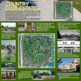
  • 1. Country Club Estates is bounded by the Florida Turnpike on the West, 441 on the East, Broward Boulevard on the North, and Peters Road to the South. Approximately half of the neighborhood is residential; sin- gle family homes and one apartment complex. The other half is a 36 hole private golf course and country club. The residents enjoy their suburban lifestyle, and although they cannot use the golf course, they appreciate its impact on the neighborhood. 81Chapter 6:Thoroughfare Designs for Walkable Urban Areas places in Europe and the United States, and the chal- lenges of the intersections have been addressed in many ways. The traditional design of multiway boulevard in- tersections is to provide stop control for the access lanes and signalized or stop control for the cross-streets and central roadway (see Figure 6.8). In urban areas, the access lanes are often controlled with traffic signals and sometimes restrict selected movements from both the central roadway and the access lanes. Common traffic control and operational configurations for traditional multiway boulevard intersections are described in Ta- ble 6.6 and illustrated in Figure 6.9. Alternative Multiway Intersection Designs Thoroughfare designers have developed a number of alternatives to the traditional multiway boulevard in- tersection. These alternatives include: • Access road slip ramps prior to and after intersec- tions to provide conventional four-leg intersections; • Forced right turns from the access lane to the cross-street. Where turning movements are re- stricted, cross-streets should be part of a well-con- nected grid of streets so vehicles leaving the access lanes can easily return to the central roadway; • Access lanes diverted away from the central roadway at cross streets increase separation and reduce the complexity of the intersection. This design concept significantly affects the place- ment of buildings at intersection corners; and • Access lanes beginning just past an intersection (either with or without a lane drop), and end- ing with or without a lane addition just before an adjacent intersection, similar to the design of frontage roads. All of the above alternatives disrupt the continuity of the access lane along the length of the boulevard. This is an important factor in considering local circulation, particularly if the access lanes provide for bicycle trav- el along the corridor. Design Examples The following design examples provide a brief synop- sis of the design process, illustrating some of the key steps in developing and evaluating solutions to thor- oughfare design problems. The examples do not rep- resent all of the possible combinations but do show some common thoroughfare situations. The four ex- amples respectively illustrate the following thorough- fare design scenarios: 1. Creation of a retail-oriented and pedestrian- friendly main street collector avenue; Figure 6.8 This multiway boulevard provides stop control for the low-volume, low-speed access lanes. The central roadway is controlled by a traffic signal. Source: Kimley-Horn and Associates, Inc. 79Chapter 6:Thoroughfare Designs for Walkable Urban Areas Property should be accessed from cross-streets or alleys, although access lanes may be intersected by local streets or consolidated driveways without direct access to the central roadway. Access lanes provide on-street parking that may be associated with curb extensions at intersections or extensions that contain street trees. The width of access lanes is composed of the parking lane (7 to 8 feet) and a shared travel lane (10 to 11 feet). Some fire de- partments may require wider access lanes. How- ever, for emergency access purposes, buildings may be able to be accessed from the central roadway. The maximum width of an access lane should be 17 feet with parking on one side and 24 feet with parking on both sides. • Median islands—raised medians are used to sepa- rate the access lanes from the central roadway. The width of these medians varies because they may serve multiple functions. At a minimum, the me- dian contains landscaping, including trees, street- lights, traffic signs and other utilities. On transit streets, the medians accommodate bus stops or stations. On multiway boulevards with very wide medians, sidewalks, seating and other urban de- sign features may be provided. Medians may be designed with mountable curbs and load-bearing surfaces on the access lane side to accommodate emergency vehicles. Median breaks are provided on some traditional multiway boulevards to allow vehicles into the access lane and entry back into the central roadway where turn movements are re- stricted at the intersections. • Streetside—provides a highly pedestrian-ori- ented environment and access to building en- trances. On residential boulevards, the streetside emphasizes planting strips or tree wells and pe- destrian-scaled lighting. On commercial boule- vards, the streetside is designed to accommodate the activities of the adjacent ground floor uses, emphasizing wide furnishing zones for street trees, seating, urban design features and street cafes. See Chapter 8 for details on the streetside. General Cross-Section Design Parameters and Right-of-Way Requirements Because of their multiple components, the multiway boulevard typically has greater right-of-way require- ments than other types of boulevards. Although street- side and median widths can vary substantially, the mini- mum right of way for a basic four-lane multiway bou- levard is 104 feet, composed of the following elements (see Figure 6.6): • 9-foot-wide streetsides; Figure 6.6 A multiway boulevard is characterized by a central roadway with a pair of one-way access lanes. This type of thoroughfare can combine high vehicular capacity with pedestrian-friendly streetsides. Source: Digital Media Productions. Provide Pedestrian/Bi- cycle connections at exist- ing dead ends to improve walkability and connectivity, by creating openings in the walls. Convert vacant land into additional park space with features such as: •skate parks •basketball courts •sports fields •exercise path equipment Develop commercial areas with high density, mixed use developments with low setbacks: Develop vacant land Redevelop poorly utilized commercial ar- eas Open key golf course paths to public pedestrian and bi- cycle use in order to provide more connectivity. Rezone internally to allow for mixed use development. Redevelop country club area to serve residents, club members, and visitors with facilities and events •restaurants overlooking the golf course •golf activities open to residents Convert SR 7 into a multi-way boulevard with medians and two thru lanes / direction •facilitate crossing •improve walkability with access to nearby neighborhoods, schools, libraries, and shopping •maintain automobile capacity Multi-way boulevards include: •separate access road with on-street parking •access road is low speed, shared by vehicles and bicycles •through lanes in center do not allow driveway or property access •transit stops in median between through lanes and access lane