WeightedOverlay2_3
- 1. Sources: Esri, USGS, NOAA Sources: Esri, USGS, NOAA
Weighted Sum Comparison With .5 - .1/.3 - .1
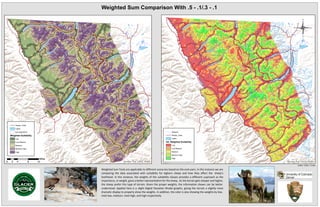
WeightedSumToolsareapplicabletodifferentscenariosbasedontheendusers.Inthisinstanceweare
comparingthedataassociatedwithsuitabilityforbighornsheepandhow theyaffectthe sheep’s
liv elihood.Inthisinstance,theweightsofthesuitabilityclassesprov idesadifferentapproachasthe
importance,orweight,giv esabetterrepresentationforthesheep.Astheterraingetssteeperandhigher,
thesheeppreferthistypeofterrain.Giv entheproperweights,theinformationshowncanbebetter
understood.AppliedhereisaslightDigitalElev ationModelgraphic,giv ingtheterrainaslightlymore
dramaticdisplaytoproperlyshowtheweights.Inaddition,thecolorisalsoshowingtheweightsbylow,
med-low,medium,med-high,andhighrespectiv ely.
0 4 8 122
Miles
Roads_Trails
Lakes
boundary2003
Weighted Suitability
Low
Low-Medium
Medium
Medium-High
High
Streams
Roads_Trails
Lakes
Alt. Weighted Suitability
Low
Low-Medium
Medium
Medium-High
High
Author: Clark J. Eckel