Cruella challenge 2011 Century Map
•
0 likes•1,115 views

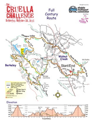
This document provides a route map and elevation profile for the 2011 Cruella Challenge Full Century bike ride around Mount Diablo, starting and ending at Oak Hill Park. The 100.8 mile route travels through various cities and parks around Mount Diablo with elevation gains up to 2,150 feet. Riders must check in at marked points along the route by specified cutoff times.

Recommended
More Related Content
What's hot
What's hot (20)
Viewers also liked
Viewers also liked (18)
Similar to Cruella challenge 2011 Century Map
Similar to Cruella challenge 2011 Century Map (20)
Recently uploaded
Recently uploaded (16)
Cruella challenge 2011 Century Map
- 1. Brought to you by: Full Century Benefiting: Route Fr a nk lin C an yo nt Ce n er cor d Mo Con Ave V a lle y rello Alh Al am bra Valley Concord Blvd ha N orth l in d o mb ch Cla + 5.0 Cro Sa an low y ton ra well oR Ga nP str il ss Re Av M ain W ab Ca Pa Pattrsn l ie e Be l h t ea Grayson z ac ar Tr ll Pe o ey Boyd Valley O a nt Hi Cr ylor Briones Da ak V a ll San Pablo ci o 4 .3 ee Gr Reservoir Mayhew m Ba Reservoir k v 0 Ta 2. na nc P le a s 5 .0 Ro a itz OakPrk Gea ry ro Ni m Yg Bail ft d 4. 80 0 Buen a W Vist a Out 4.1 alnut Creek I-6 + ( ay W ley Pt. pa ar Happ Ave th ) dy al bar y Val V Wildcat Can Be Lom Sundo wn o yon le a ci 1 .0 2. 2. 9 3 2.6 4.1 y Ygn 1.0 w CA24 Walnut Miner N 1.3 Gr th or Sou Creek El 1. iz Ca 1. Relie 1.7 S .M th 1 ino pic zl Ga 1 Mt.Diablo To P Moraga Olym 1.5 m G 1. ark y Mt D iablo t . ta yo M oraga Rd Ca n a d (pat olf ain N ewell 4 1 .1 as te -Lilac z St h) a Pa na Sh .M .5 Castle Hill ie t t Ple as ary l 1 o it bl ’s 7. 4.2 1 .8 T ic 2.8 mm 6 1 .3 Lo s 24 Rhe Va Su G r iz G lo r e l ley Cr a nt H Berkeley CA em Gle n side Start/End est 2.2 w z ly .7 FishRanch ade 1.3 5 .2 ill r HillG Dan M Green Vll So 3. Stone V + n. 2 alle orag 's Pe Tu ak 1 .8 v i ll e y ut h 3. ary B lv d W I- 8 y Terr y a wa ay D ia b lo . c e nic B 68 M Bl 0 +Moraga 6.5 G at e vd 1.5 St e 2 + erro ak .1 El C Mt S p. e Mt.Diab n Sn Sh 4. lo Bla yo 0 Can CA Pin c Commons 3.4 Mt.Diablo Rd Cam 3. Sk y e 8 13 1. ino kh a w k hu Ta 5 ne ss li Jo aq. Sycamore Valley 2. r st Re aja 7 Millr. dw 2. ra Less Traffic/Lower Posted Speed 2 .2 ood San 5 Bo 4. Moderate Traffic/Speed Leandro El Capitan 4 lin Heavy Traffic/Higher Speed er en .7 Reservoir g Highway or Restricted Sk 4.6 Ca Gre ook Canyon S t Ge BART Station yl ny br Crow 2.4 in on - 4% 6% % Rider Check Pt. e o + 2- 4- 6 + ght od eep Rest Stop sli m st Grade w Water Chevron points uphill Intermediate mileage marker Start/Finish Elevation 2150’ Mt. Diablo W “Junction” 2150’ 2150’ 2150’ Mt. Diablo “Double Junction” W 91.7 miles 1800’ 1800’ Bail Out Grizzly Peak 1800’ 1800’ SouthGate NorthGate Skyline Gate 1450’ 1450’ Point + 1450’ 1450’ 1100’ 1100’ The Bears Wildcat Cyn 1100’ 1100’ 750’ Start 750’ “Pig Farm” Hill 750’ Oak Hill Park 750’ M.Commons LDS + W 100K R + + 400’ 400’ + oute 400’ 400’ + Alhambra Camino Finish@ Finish Pablo M.Commons OH Park 50’ 50’ 0 3.5 7 10.5 14 17.5 21 24.5 28 31.5 35 38.5 42 45.5 49 52.5 56 59.5 63 65.5 70 73.5 77 80.5 84 87.5 91 94.5 100.8 Feet/Miles