Mali Elephant Project - Fire-breaks in the Gourma 2011
•
0 likes•715 views

Learn more about fire-breaks in the Gourma region of Mali (west Africa) and how this relates to the Mali Elephant project. To learn more about the Mali Elephant Project, visit The WILD Foundation at www.wild.org.
![Trace the guide line that forms on boundary of the fire-break ,[object Object],[object Object]](data:image/gif;base64,R0lGODlhAQABAIAAAAAAAP///yH5BAEAAAAALAAAAAABAAEAAAIBRAA7)
Recommended
More Related Content
Viewers also liked
Viewers also liked (18)
More from WILD Foundation
More from WILD Foundation (20)
Recently uploaded
Recently uploaded (20)
Mali Elephant Project - Fire-breaks in the Gourma 2011
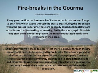
- 1. Fire-breaks in the Gourma Every year the Gourma loses much of its resources in pasture and forage to bush fires which sweep through the grassy areas during the dry season when the grass is tinder dry. These are generally caused accidentally from activities such as tea-making, or smoking, but in the south, agriculturalists may start them in order to prevent the transhumant cattle herds from staying in their area. A pastoral reserve is made to ensure that there is pasture through the dry season but it needs to be protected by fire breaks. These take a good deal of effort to construct but are very effective if done properly. They also require a great deal of community organization to bring differing clans and ethnicities to work together. Supporting this activity is a good way to instantly increase the amount of natural resources available to the population. Dr Susan Canney March 2011
- 3. Here, for the firebreak protecting the pastoral reserve, the guide furrow has been cleared by camels dragging branches behind them and going over the same area several times….
- 4. 6-9 camels were used and branches dragged over each spot at least 6 times. An area of 30m to one side is then cleared from the furrow to form the fire-break
- 5. A team of 12 clear the vegetation with rakes
- 6. Where the grass is long the vegetation is cleared by back-burning from the guide furrow against the wind to make control easier.
- 7. Where the grass is short, the grass is not cleared by burning because the fire takes too long to pass and burns the seeds in the soils. With long grass the fire burns quickly over the top of the soil surface.
- 8. The fire is controlled using beaters, as demonstrated by Ganame in this photo, and the process is accompanied by prayers and readings from the Koran by marabouts
- 9. Map showing the location of the pastoral reserve (green and black line) covering an area of 923,800 hectares in relation to the three commune boundaries and the water points (in pink). The red line shows the PCVBG-E’s proposed “Aire de Conservation”