Data visualization
•Download as PPTX, PDF•
0 likes•54 views

Data visualization for Oil and Gas data

Recommended
Recommended
More Related Content
Similar to Data visualization
Similar to Data visualization (20)
Recently uploaded
Recently uploaded (20)
Data visualization
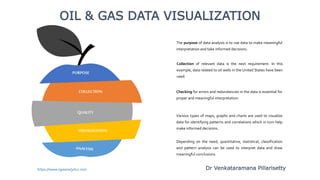
- 1. The purpose of data analysis is to use data to make meaningful interpretation and take informed decisions. OIL & GAS DATA VISUALIZATION Collection of relevant data is the next requirement. In this example, data related to oil wells in the United States have been used. Checking for errors and redundancies in the data is essential for proper and meaningful interpretation. Various types of maps, graphs and charts are used to visualize data for identifying patterns and correlations which in turn help make informed decisions. Depending on the need, quantitative, statistical, classification and pattern analysis can be used to interpret data and draw meaningful conclusions. https://www.ogaanalytics.com VISUALIZATION QUALITY COLLECTION PURPOSE Dr Venkataramana Pillarisetty
- 2. US PETROLEUMBASINS 20,000sq mi 61,763sq mi 23,000sq mi 200,000sq mi Eagle Ford Basin. Permian Basin. Niobrara Basin. Bakken Basin. CRUDE OIL PRODUCTION – (2007 -2019) 4 Major Petroleum Basins in US Permian (Texas, New Mexico, Colorado) Eagle Ford (Texas) Bakken (Montana, Dakota) Niobrara (Colorado, Wyoming) Data from US Energy Information Administration (EIA)https://www.ogaanalytics.com
- 3. OIL WELL LOCATION MAP Oil Wells Producing Oil Wells WHITE COUNTY, ILLINOIS Data from: Illinois State Geological Survey. https://www.ogaanalytics.com
- 4. Data from: US Energy Information Administration (EIA) & Bureau of Ocean Energy Management (BOEM). GULF OF MEXICO OIL WELLS F R O M T W O W E L L D E P T H R A N G E S In the Gulf of Mexico more than 55,000 wells have been drilled. GOM WELLS TVD subsea 100 – 5,000 feet. TVD subsea 30,000 – 37,000 feet. https://www.ogaanalytics.com
- 5. US CRUDEOIL PRODUCTION (FROM 1920 to 2019) Data from: US Energy Information Administration(EIA). Though US has produced record crude oil in 2018 & 2019, US EIA predicts crude oil production to fall in 2020 and 2021 because of Covid-19 . https://www.ogaanalytics.com
- 6. US NATURAL GAS PRODUCTION (FROM 1980 to 2019) Data from: US Energy Information Administration(EIA). Though US has produced record natural gas in 2018 & 2019, US EIA predicts natural gas production to fall in 2020 and 2021 because of Covid-19 . https://www.ogaanalytics.com
- 7. US CRUDE OIL Texas, North Dakota, New Mexico, Colorado, California, Alaska, Oklahoma and Gulf of Mexico are the major crude oil producers in US. US CRUDE OIL PRODUCTION Y E A R 2 0 1 9 ( T h o u s a n d B a r r e l s ) Data from: US Energy Information Administration (EIA) https://www.ogaanalytics.com
- 8. US NATURAL GAS Texas, Pennsylvania, Alaska, Oklahoma, Colorado, Louisiana, New Mexico are the major natural gas producers in US. US NATURAL GAS PRODUCTION Y E A R 2 0 1 9 ( M i l l i o n C u b i c F e e t ) https://www.ogaanalytics.com
- 9. OIL PRODUCTIONIN ILLINOIS COUNTIES IN ILLINOIS (2018) Data from: Illinois State Geological Survey. Illinois has been a major oil producing state in US. 67.9% of the crude oil produced in Illinois has come from 7 counties: White, Marion, Crawford, Lawrence, Fayette, Wabash andWayne. ILLINOIS OIL https://www.ogaanalytics.com
- 10. COMPARATIVE STUDY OIL & GAS PRODUCTION IN DIFFERENT STRATIGRAPHIC FORMATIONS Data from: Geological Survey of Alabama & State of Alabama Oil & Gas Board Norphlet, Smackover, Frisco City and Rodessa are the main oil and gas producing formations and account for 89.5 % crude Oil and 70.8 % natural Gas production in Alabama. ALABAMA OIL & GAS https://www.ogaanalytics.com
- 11. HEAT MAP DEPECTING OIL PRODUCTION KANSAS (total up to 2019) Data from: Kansas Geological Survey. KANSAS OIL Kansas has been a major oil and gas producing state in US. Ellis, Rush, Rooks, Russell counties are the major oil producing counties in Kansas. https://www.ogaanalytics.com
- 12. COAL BEDMETHANEPRODUCTION ALABAMA (total up to 2017) ALABAMA CBM Coal Bed Methane (CBM) is produced in 7 counties in Alabama. Tuscaloosa and Jefferson are the major CBM producers located in the Warrior Basin,Alabama. Data from: Geological Survey of Alabama & State of Alabama Oil & Gas Board
- 13. STRATIGRAPHY CLOUD MAP O I L B E A R I N G F O R M A T I O N S I N I L L I N O I S YOUR TITLE Major source of crude oil in Illinois is McClosky, Spar Mountain, and Aux Vases sandstone formations of Mississippian Age. Nearly 80% of the crude oil produced in Illinois has come from Mississippian rocks. Data from: Illinois State Geological Survey. https://www.ogaanalytics.com
- 14. STRATIGRAPHIC CORRELATION GAMMA RAY LOG & LITHOLOGY Using gamma ray logs, bore well lithologies can be correlated. Innovation Gamma Ray logs Lithology logs https://www.ogaanalytics.com
- 15. 01 02 Rate Vs Cum Prod Rate of crude oil production plotted against cumulative production to interpret future production. Rate Vs Time Rate of crude oil production plotted against time to interpret future production. QUANTITATIVE DATA ANALYSIS https://www.ogaanalytics.com