
Recommended
More Related Content
What's hot
What's hot (20)
Similar to Design vi
Similar to Design vi (20)
Recently uploaded
Recently uploaded (20)
Design vi
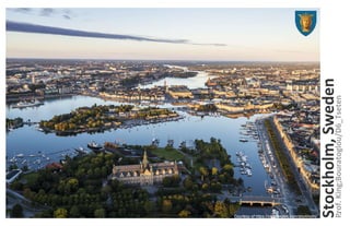
- 1. Stockholm,Sweden Courtesy of https://visitsweden.com/stockholm/ Prof.King;Bouratoglou/D6_Tseten 1
- 2. Stockholm, Sweden Capital of Sweden Archipelago Total area: 2,249,657,277 Sq/ft Land: 2,023,615,158 Sq/ft Water: 226,042,118 Sq/ft ~10% Population recorded from 2016: 935,619 County of Stockholm 2Stockholm Municipality:
- 3. What was the waterfront used from in the history? ● Origin: ○ Stockholm was known as Stadsholmen(meaning “Island of city”). ○ Connected to the baltic trade route ○ German influence ● 14th Century: ○ Trading ships called "Cog" not able to reach the iron mines due to their ship size, Stockholm becomes a trading port ● 17th Century ○ Stockholm becomes a Navy Shipyard ○ Migration of skilled worker from other countries to build ships ● 18th Century: ○ First building regulations after fire ● 19th Century: ○ Industrial migration. Rural population were moving to cities ○ Stockholm able to meet this influx because of proper city planning(sanitation and hygiene) ○ Many of the ports were converted over to Schools, Libraries, Museum and Hospital around 1860. ● 20th Century: ○ 1950-60’s - Population increase ○ Container shipping kills the local ports shipping trade business ● 21st Century: ○ Ports support cruise station, and container shipping; NASDAQ (Stock Exchange) ○ City is moving towards a plan,“Vision 2040”, to be sustainable What caused the change at the waterfront? Industrialization of the 19th century helped grow the port of stockholm into an a fully functioning city. Courtesy of Chatterton, E. Keble. History of the Sailing Ship. New York: Argosy-Antiquarian, 1968. 3
- 4. 4 Space Designation: Material Courtesy of https://goo.gl/AkXHLJ
- 5. Transportation: Congestion ● Stockholm is supported by Trams, Ferry, Cycle, Bus, Railroad, Subways. ○ Congestion Tax: -20% traffic ■ Entry into the city through the 18 points are taxed 5, 10, 15, 25 Krona. ■ 5 kr = $0.63 10 kr = $1.27 15 kr = $1.90 20 kr = $2.53 ■ Taxi and Government run transportation vehicles are not taxed. ■ 30 minute bypass window to avoid tax 5
- 6. Transportation: Transit System 2070 Expansion plan: One new line and extension of the existing. 6
- 7. Transportation: Cycling Center represents Main cross-point for the city Transit. Blue circles represent cycle rental points. 7
- 10. 10 Sustainability: All Material Courtesy of https://stockholmdataparks.com/wp- content/uploads/a-brief-introduction-to-district-heating-and-district- cooling_jan-2017.pdf
- 11. 11 Sustainability: All Material Courtesy of https://stockholmdataparks.com/wp- content/uploads/a-brief-introduction-to-district-heating-and-district- cooling_jan-2017.pdf
- 13. Reference: Port History: http://www.worldportsource.com/ports/review/SWE_Ports_of_Stockholm_442.php Port History: https://www.migrationpolicy.org/article/sweden-restrictive-immigration-policy-and-multiculturalism Name origin https://www.discoverworld.com/Sweden/Stockholm-County/Stockholm-Municipality/Stadsholmen Killing of the ports Pg.198 https://books.google.com/books?id=JkB-AgAAQBAJ&pg=PA231&lpg=PA231&dq=Stadsholmen&source=bl&ots=-fOY54Uf7_&sig=6ZO2l- Ch2wQO-Ig6O3YFj_Ac9xE&hl=en&sa=X&ved=0ahUKEwjEnPepoojZAhVHw1kKHYzgAGEQ6AEIWjAH#v=onepage&q=ports&f=false History of stockholm https://www.researchgate.net/profile/Angelos_Kastritis/publication/308483411_Mapping_Port- Towns_from_the_16th_to_19th_centuries_Stockholm_and_Thessaloniki/links/57e4f10508ae9e8425a4a857/Mapping-Port-Towns-from-the-16th- to-19th-centuries-Stockholm-and-Thessaloniki.pdf Stockholm building use area https://www.sciencedirect.com/science/article/pii/S019897151500023X#f0005 Fact of stockholm population http://www.stockholm.se/OmStockholm/Fakta-och-kartor/ Map of stockholm(hidden layers) http://vaxer.stockholm.se/globalassets/tema/oversiktsplanen/promenadstaden_oversiktsplan-for-stockholm_plankarta.pdf District heating https://stockholmdataparks.com/wp-content/uploads/a-brief-introduction-to-district-heating-and-district-cooling_jan-2017.pdf Heath graph https://www.sciencedirect.com/science/article/pii/S0360544217304140#fig1 Map with no legend http://kartor.stockholm.se/bios/dpwebmap/cust_sth/sbk/sthlm_sse/DPWebMap.html?zoom=4&lat=6579685.15166&lon=153428.76772&layers=TT TB00000000 http://kartor.stockholm.se/bios/dpwebmap/cust_sth/sbk/sthlm_sse/DPWebMap.html?zoom=4&lat=6578800&lon=154000&layers=TTT0B0000000T County map of stockholm http://vaxer.stockholm.se/globalassets/tema/oversiktsplanen/promenadstaden_oversiktsplan-for-stockholm_plankarta.pdf 2016 plans http://www.stockholmroyalseaport.com/ City Development http://vaxer.stockholm.se/tema/oversiktsplan-for-stockholm/ http://open.stockholm.se/oppna-data/geodata/ 13