Remote Sensing and GIS Applications in Modern Agriculture Management
Explore how remote sensing and GIS technologies enhance agricultural monitoring, crop health analysis, soil mapping, and resource management for sustainable farming and environmental impact assessment.
Remote Sensing and GIS Applications in Modern Agriculture Management
1.
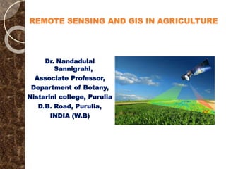
REMOTE SENSING ANDGIS IN AGRICULTURE
Dr. Nandadulal
Sannigrahi,
Associate Professor,
Department of Botany,
Nistarini college, Purulia
D.B. Road, Purulia,
INDIA (W.B)
2.
AGRICULTURE AND PROSPECTS
Agriculture is the most important components of almost all he nations in
general and developing and under developed countries in particular,
The development of agriculture and its output depends on the different
variables along with the prediction of the different risk factors and
management practices,
Precise information, crop monitoring, pest and disease forecasting,
weather adaptability, along with the environmental impact are mostly
essential for the cost-effective management of agriculture systems,
Sustainable food supplies only to be ensured by the sustainable
agriculture outputs in the large scale to meet up the growing demands of
the global market,
Besides government and official statistics, ground data either in active or
passive forms are essentially needed to expedite the process along with
the data interpretation and monitoring systems,
The Remote sensing (RS) and Geographical Information System (GIS)
through satellite based optical and radar Imagery empowered with
computer driven data analysis through sensors available from different
sources are essential in this regard.
3.
REMOTE SENSING
Remotesensing is the acquisition of information about an object or
phenomenon without making physical contact with the object and
thus in contrast to on-site observation.
Remote sensing is used in numerous fields, including geography, land
surveying and most Earth Science disciplines (for example,
hydrology, ecology, oceanography, glaciology, geology); it also has
military, intelligence, commercial, economic, planning, and
humanitarian applications.
In current usage, the term “Remote Sensing" generally refers to the
use of satellite- or aircraft-based sensor technologies to detect and
classify objects on Earth, including on the surface and in the
atmosphere and oceans, based on propagated signals (e.g.
electromagnetic radiation).
It may be split into "active" remote sensing (i.e., when a signal is
emitted by a satellite or aircraft and its reflection by the object is
detected by the sensor) and "passive" remote sensing (i.e., when the
reflection of sunlight is detected by the sensor).
4.
GEOGRAPHICAL INFORMATION SYSTEM(GIS)
Geographical Information System (GIS) combines location data with
both quantitative and qualitative information about the location, allowing
you to visualize, analyze, and report information through maps and charts.
Using the technology, you can answer questions, conduct what-if
scenarios, and visualize results.
GIS is identified as a system used to manage infrastructure assets, natural
resources and any objects as per requirement. It is easier to analyze and
manage facility and asset data stored in GIS, making design, construction,
and maintenance more efficient and profitable.
GIS is a software based system which facilitates end to end information of
assets or any type of objects as required by end user on maps having
desired accuracy in raster and vector forms.
GIS aids geographical location, parent child relationship, unique
identification, attributes, technical parameters, 2D/3D view and any other
requirement customized.
GIS information/data is most adoptable, accurate and user-friendly to meet
general requirements of operations and other software applications. Using
main GIS application, other GIS based applications can be easily
developed to meet specific requirements of users.
5.
GEOGRAPHICAL INFORMATION SYSTEM(GIS)
Remote sensing involves the use of sensors mounted on aircraft or
satellites to gather information about the Earth's surface from a
distance. The data collected from RS enables the monitoring of
changes in the Earth's surface, including land use, vegetation, water
bodies, and other environmental parameters.
On the other hand, GIS is a computer-based system that enables the
capture, storage, manipulation, and analysis of spatial data.
Integrating RS and GIS provides a powerful platform for analyzing
and managing agricultural data.
Agricultural plant, as living organisms require water along with the
nutrient for its growth and productivity and they are sensitive to
different stress conditions like drought, flood, diseases and nutrient
deficiency.
Remote sensing data is organized in a Geographical Information
System (GIS) along with the other parameters and they become
important tool in making the decisions about crops health status and
design agricultural strategies.
6.
REMOTE SENSING
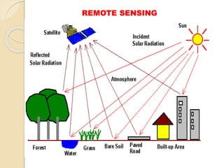
Remotesensing is the art and science in order to process of detecting
and monitoring the physical characteristics of an area by measuring
its reflected and emitted radiation at a distance (typically from
satellite or aircraft). Special cameras collect remotely sensed images,
which help researchers "sense" things about the Earth. Some
examples are:
Cameras on satellites and airplanes take images of large areas on the
Earth's surface, allowing us to see much more than we can see when
standing on the ground.
Sonar systems on ships can be used to create images of the ocean
floor without needing to travel to the bottom of the ocean.
Cameras on satellites can be used to make images of temperature
changes in the oceans.
Remote sensing may be active or passive depending on the energy
sources,
The common platforms in this domain re the uses of satellites
(LINDSAT) or drones and aircrafts for the same.
WORKING MODULE OFREMOTE SENSING
The art and science of Remote sensing is quite complex considering
the working principles of energy sources. Transmission, data retrieval
and analysis along with the image generation. The entire landscape
can be summarized as below:
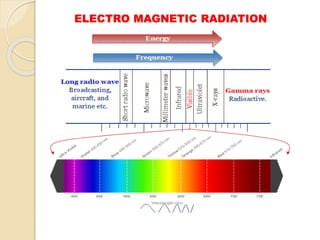
Source of Electro Magnetic Radiation(EMR) either from the sunlight
or any other sources as the key components in this domain,
Energy transmission between the source of earth’s surface and the
interaction with the atmosphere,
Interaction with the electro magnetic radiation (EMR) with earth
surface /target reflected absorption , transmission and self-emission,
Transmission or reflected/emitted radiation to sensors,
Signal detection by sensors on board and conversion to photographic
or electrical output,
Transmission /recording of sensor outputs,
9.
WORKING MODULE OFREMOTE SENSING
Pre-processing of sensor output including radiometric /geometric
corrections,
Ground truth and other information,
Interpretation of data and collection of information,
The truth in the ground level from the data has been obtained by the
sensors through satellite images now be converted into physical map (
satellite map) to be used for the next steps to be involved for desired
working module,
In case of agriculture or other natural resources management practices,
different set of maps are constructed for the same,
In case of agriculture management systems, the different types of
maps are constructed for agricultural land monitoring,
The different attributes are framed using this sophisticated tools from
the far off without even the physical visit of the plot.
10.
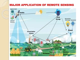
MAJOR APPLICATION OFREMOTE SENSING
The Remote Sensing , the art and science plays a very significant role
in agriculture and resource management along with diverse holistic
issues in the modern days of data highway. Some of the features as
stated below:
Agricultural land monitoring
Soil mapping,
Crop System analysis,
Crop pest/ disease detection,
Land use along with land cover mapping,
Crop condition monitoring including nutrients/water/ other resources,
Soil moisture status,
Water resource /command area management,
Disaster management particularly soil erosion, forest fire, earthquake,
and other natural issues,
The acute management of the different natural resources in the
context of growing emergent environmental issues.
MAJOR APPLICATION OFREMOTE SENSING
Irrigation and its monitoring and management,
Soil mapping-
Monitoring of drought condition and other natural issues affects
adversely on the resources,
Identification of the problematic soil not good for the standing crops,
The nutrient deficiency as suffered by the cops,
Flood mapping and monitoring particularly I the flood prone areas,
Water resources mapping particularly the soil suffered from severe
water scarcity issues,
Climate change mapping specially in the emerging context of climate
change and global warming,
Soil management practices for the optimum utilization of this most
important renewable natural resources,
Crop health analysis to ensure sustainable productivity,
Land mapping for proper land utilization.
ENERGY SOURCE ANDDATA CAPTURE
Energy travels from the source either active or passive to target, it will
come in contact and interact with the atmosphere in course of its
travelling to the object,
The effects are caused by the mechanism of scattering and absorption,
Scattering occurs when particles or large gas molecules present in the
atmosphere interact with and cause electro magnetic radiation to be
redirected from its original path,
Scattering of the light depends on several factors as far as the laws of
scattering of lights- wavelength of the radiation, the abundance of
particles or gases and the distance travel by the light during to and fro
movement,
Three types of scattering re observed- Rayleigh Scattering, Mie
Scattering and Non-selective scattering.
Three forms of interaction take place- Absorption, Transmission and
Reflection,
After the energy has been scattered by or emitted from the target, sensor
generally collect and record EMR,
Transmission to be recorded by sensor and the data are processed into an
image either hard copy or digital forms.
15.
SENSORS & PLATFORMSUSED IN REMOTE
SENSING
To improve the accuracy and reduce uncertainties in input data, remote
sensing data is integrated into crop simulation models.
The remote sensing data provides valuable information on crop
characteristics, such as vegetation indices, leaf area index, chlorophyll
content, and crop height.
This results in more accurate input data, which enhances the accuracy
of crop simulation models. In addition, remote sensing data allows for
better understanding of crop growth and development, as it provides
improved spatial and temporal resolution.
‘Sensor’ is the remote sensing device that records wavelengths of
energy. Generally, these sensors are mounted or fixed with a
‘platform’. Therefore, ‘platform’ is termed as a vehicle that carries
remote sensing device.
Platform is a stage where sensor or camera is mounted to acquire
information about a target under investigation.
Platforms can vary from stepladders to satellites. There are different
types of platforms and based on its altitude above earth surface.
16.
SENSORS & PLATFORMSUSED IN REMOTE
SENSING
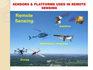
Platforms may be of different types as per the mode of uses with respect
to data harvestation -
Ground based platforms- tripods, towers, cranes,
Balloon platforms- may be of different shapes, sizes
Aircrafts platforms- either low altitude or high altitude ,
Rockets platforms- aerial photographs by rocketing camera like The
Skylark earth resource rocket,
Spacecraft- from the space shuttle or artificial satellite like LANDSAT
and Spot satellite programme, it may be two types-
a) Sun synchronous (In sun-synchronous orbit, satellite is orbiting in
synchronous with sun. In this type of orbit, satellite passes every location
at the same time each day. Such an orbit is near polar with altitudes
between 300 and 1000 km. They are also known as “polar orbiters”
because of the high latitudes they cross
b) Geostationary i.e. (In geosynchronous orbit, satellite in synchronous
with earth. It is basically designed to maintain a constant position with
respect to a specific portion of the earth’s surface area day and night
).These satellites move along in the same direction of the rotation of the
earth, taking the same amount of time as the earth’s rotation
SENSORS & PLATFORMSUSED IN REMOTE
SENSING
Sensor is a device that gathers energy (EMR or other), converts it into
a signal and presents it in a form suitable for obtaining information
about the target under investigation. According to Jensen (2000),
remote sensors are mechanical devices, which collect information,
usually in storable form, about objects or scenes, while being at some
distance from them. Sensors used for remote sensing can be either
those operating in Optical Infrared (OIR) region or those operating in
the microwave region. Depending on the source of energy, sensors are
categorized as active or passive:
ACTIVE SENSORS are those, which have their own source of EMR
for illuminating the objects. Radar (Radio Detection and Ranging) and
LiDAR (Light Detection and Ranging) are some examples of active
sensor. Photographic camera becomes an active sensor when used with
a flash bulb. Radar is composed of a transmitter and a receiver. The
transmitter emits a wave, which hits objects in the environment and
gets reflected or echoed back to the receiver.
The main advantage is that active sensors can obtain imagery in
wavebands where natural signal levels are extremely low and also are
independent of natural illumination. The major disadvantage with
active sensor is that it needs high energy levels, therefore adequate
inputs of power is necessary.
19.
SENSORS & PLATFORMSUSED IN REMOTE
SENSING
PASSIVE SENSORS do not have their own source of energy. These
sensors receive solar electromagnetic energy reflected from the surface or
energy emitted by the surface itself. Therefore, except for thermal sensors
they cannot be used at night time.
Thus in passive sensing, there is no control over the source of
electromagnetic radiation. Photographic cameras (without the use of
bulb), multispectral scanners vidicon cameras etc. are examples of
passive remote sensors.
The advantage with passive sensor is that it is simple and do not require
high power. The disadvantage is that during bad weather conditions the
passive sensors do not work. The Thematic Mapper (TM) sensor system
on the LANDSAT satellite is a passive sensor.
Beside the sensors, scanners are also used for the same of diverse types-
Whiskbroom, Push broom scanner etc.
The sensors may be of different types based on their characteristics-
optical infrared sensors either may be visible/ near infra red remote
sensing, thermal infra red remote sensing etc for the data exploration by
the desired sources.
20.
STEPS INVOLVED INREMOTE SENSING
The followings steps are involved in the remote sensing study for the
agriculture and natural resource management:
Energy source and Illumination- Here, the energy source either active or
passive is used in the form of EMR to the target of the resources,
Radiation and the atmosphere- the target and the atmosphere where the
interaction are done should be accurately measured,
Interaction with the object- the object under study is delicately monitored,
Recording of energy by the sensors- whether active or passive, sensors
are deployed to record the energy from where the EMR is dissipated from
the object under the study,
Transmission, Reception and Processing- the transmission of energy,
Reception and processing are done for the same encounters,
Interpretation and analysis- the ground stations for the same as big met
data are interpreted and analyses to get the ground picture through
different software along with the digital mapping of the resources,
Application- the post analysis should be accompanied with diverse
application.
21.
ADVANTAGES OF REMOTESENSING
To survey large and inaccessible areas within short time and desired
interval, remote sensing has no alternative for the natural resource
management and other important issues like natural disasters and other
calamities,
Can be used and analyzed multiple types for different purposes as dreamt,
Remote sensing & GIS can collects data and can be analyzed with desired
software like LiDAR,
The light used in remote sensing for the multiple purposes even for
human is harmless to objects, vegetation without any detrimental effects,
The art and science of remote sensing is very easy in order to collect data
over a variety of scales and resolutions,
It is the most sophisticated tool and technology garnished with different
sensors that is highly dependable with wide degree of scientific accuracy,
The GIS & RS based on different platforms can be used for multiple
purposes in the domain of data revolution and interpretation.
22.
DISADVANTAGES OF REMOTESENSING
The sophisticated technology for GIS & remote sensing is very
expensive of analyzing in smaller areas specially for the developing
and under developed nations suffering from the technology skill and
financial resources,
It can not offer high resolution data as the sensors capture data from
far off the target objects and the storage capacity is serious concern
as far as meta data is issue,
It needs comprehensive training of the skilled man power empowered
with delicate and costly software,
The instruments need proper calibration to achieve accurate data,
Last but not least, the money is the most important constraints
particularly for sending the satellites or hiring the same for the
different purposes only to get data and its ground network facilities to
capture data and to retrieve data.
23.
THANKS FOR YOURVISIT
ACKNOWLEDGEMENTS:
a. Google for images,
b. Different websites for enriching the course content,
c. Science Direct pages,
d. Plant diseases, insects and pests- NCBI-NH,
e. International Journal of Advanced Engineering Research and Science , ol-
5, Issue-4, April-2018.
f. www.nature.com
g. www.aphis.usda.gov
h. https://www.un.org/en/climatechange/science/causes-effects-climate-
change
i. www.fao.org
j. Many more websites for references.
DISCLAIMER:
This presentation has been designed to address the academic fraternity
without any financial interest. This is absolutely free to use . The author
does not claim any kind of financial benefits from this content
 Most read
 Most read