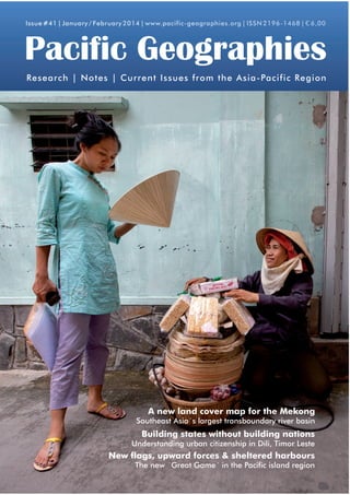
Issue #41 | January / February 2014 | www.pacific-geographies.org | ISSN 2196-1468 | € 6,00

Pacific Geographies
Research | Notes | Current Issues from the Asia-Pacific Region

The System of Rice Intensification (SRI)
Challenges the Mekong
A new land cover map for for Timor-Leste

Southeast Asia´s largest transboundary river basin

Heritage Preservation in Cambodia
Building states without Case of Battambang
The building nations

Understanding urban citizenship in Dili, Timor Leste

Whale Watching in Patagonia, Chile
New flags, upward forces &Sustainable Ecotourism?
Guaranteeing a sheltered harbours
The new ´Great Game´ in the Pacific island region
CONTENTS #41 | January/February 2014

Building states without building nations: understanding urban citizenship in Dili, Timor Leste – 15

New flags, upward forces and sheltered harbours: The new
‘Great Game’ in the Pacific Islands region – 4

04	


10	


15	


2

Green Open Spaces in Indonesian cities: schisms between
law and practice – 26

New flags, upward forces and sheltered 	 20	
Conservation, REDD+ and the struggle 	
for land in Jambi, Indonesia
harbours: The new ‘Great Game’ in the 	 	
Pacific Islands region
	
Jonas Hein & Heiko Faust
Matthias Kowasch & Peter Lindenmann
26	
Green Open Spaces in Indonesian cities: 	
A new land cover map for the Mekong: 	
	
schisms between law and practice
Cosima Werner
Southeast Asia’s largest transboundary 	 	
river basin
Patrick Leinenkugel, Natascha Oppelt & 	
32	Advertisement
	
TP Hồ Chí Minh: MEGA City Photo Book
.
Claudia Kuenzer
	
Michael Waibel & Henning Hilbert (eds.)
Building states without building nations: 	
understanding urban citizenship in Dili, 	 	
Timor Leste
Alix Valenti

Pacific Geographies #41 • January/February 2014
EDITORIAL
Dear readers,
In November 2013, typhoon Haiyan (Yolanda) caused widespread devastation in South-east
Asia. Being the second strongest typhoon since the beginning of weather recordings, Haiyan
caused several thousand deaths and displaced several million people in the Philippines alone.
We wish to express our deepest sympathy with the victims and their families.
As the disaster happened after the editorial deadline there are no related contributions in the
current issue. However, three authors address other environmental topics. Introducing a regionally specific land cover map, Patrick Leinenkugel (German Remote Sensing Data Center of
the German Aerospace Center [DLR]) and his colleagues advocate transboundary approaches
based on consistent and comparable information in the Mekong basin. Jonas Hein (German
Development Institute) and Heiko Faust (Department of Geography, Göttingen University) discuss stakeholders, coalition-building and discourses in the context of Indonesia’s first private
ecosystem restoration concession, the Hutan Harapan project in Jambi. Cosima Werner, a
graduate student of Erlangen University, discusses the impacts of a recent Indonesian national
government law that postulates that 30% of urban areas shall be occupied by so-called green
open spaces.
After much positive feedback on the last issue on environmental politics, coordinated by
our colleague Dr Jan Mosedale, we have decided to have special issues on a more regular
basis in the future. We hereby invite potentially interested scholars to submit proposals for
special issues on relevant topics of their choosing. Please contact us to propose topic areas
that require in-depth analysis and discussion. Any special issue can accommodate four to five
papers on the topic area. We thank you in advance for your interest and, as always, wish you
pleasant read.
Best regards, the editors

Pacific Geographies

Pacific Geographies (PG), ISSN 2196-1468, is a peer-reviewed semi-annual
publication published by the Association for Pacific Studies (Arbeitsgemeinschaft
für Pazifische Studien e.V., APSA) in co-operation with the Department of Human
Geography of Hamburg University, Germany. The PG provides an interdisciplinary
platform for an academic discussion of social, cultural, environmental, political and
economic issues in the Asia-Pacific region.
In order to uphold scientific standards, the PG is implementing a peer-review process.
Articles marked as „scientific papers“ have been peer-reviewed by two external reviewers. Articles marked as „research notes“ have been peer-reviewed by one external
reviewer and a member of the editorial board. All other articles have been reviewed
by the editorial board.
APSA-Members receive the Pacific Geographies at no cost as a membership benefit.

The Association for Pacific Studies (Arbeitsgemeinschaft für Pazifische Studien e.V.,
APSA) was founded in 1987 at the Department of Geography of the University of
Technology in Aachen. Activities include workshops, conferences, public lectures
and poster exhibitions. The book series Pazifik Forum was initiated in 1990. In 1992,
it was complemented by the publication of the journal Pacific Geographies. The latter
has developed into the major activity of APSA in recent years.
The APSA sees itself as one of the largest scientific networks in Germany for academics and practitioners with an interest in the Asia-Pacific region as well as ­ cademic
a
exchange.
Pacific Geographies #41 • January/February 2014

IMPRINT:
Editorial Board:
Dr. Michael Waibel (v.i.S.d.P ­
.),
University of Hamburg
Dr Julia N. Albrecht,
Victoria University of Wellington
Scientific Advisory Board:
Dr Tara Duncan, Department of
Tourism, University of Otago, NZ
Dr. Rolf Jordan, Dep. of Geography,
University of Vienna
Dr Jan Mosedale, University of
Applied Sciences HTW Chur
Prof. Dr. Jan-Peter Mund, University
of Applied Sciences, Eberswalde
External Reviewers:
Dr Julia Albrecht, Victoria University
Wellington, NZ
Leole Malama, Victoria University
of Wellington, NZ
Dr. Harald Kirsch, Chiang Mai
Anna Huebner, Gesellschaft für
Internationale Zusammenarbeit
Dr. Martin Noltze, Deutsches Evaluierungsinstitut der Entwicklungszusammenarbeit gGmbH
Prof. Dr. Jan-Peter Mund, University
of Applied Sciences, Eberswalde
Prathiwi W. Putri, Department of
Architecture, KU Leuven
Layout Print Version:
Arne Löprick
All material published in the Pacific
Geographies expresses the views
and opinions of the authors of this
material.
Please submit your manuscript to:
waibel_michael@yahoo.de or
julia.albrecht@vuw.ac.nz
Association for Pacific Studies
(APSA), in co-operation with the
Department of Geography
University of Hamburg
Bundesstrasse 55
D-20146 Hamburg, Germany.
COVER PICTURE
Street seller Nuong & customer
© Astrid Schulz 2013
The 33 years old Nuong has been working in District 8 of Ho Chi Minh City for
3 years. She is selling diverse goods in
the street and sends most of the money
she makes to her family back home. She
is making around 100,000 Vietnamese
Dong a day, in comparison to 40,000 in
her home town. For the time being she
rents a bed in shared accommodation.
This picture has been published as part of
the publication „TP Hồ Chí Minh: MEGA
.
City Photo Book“ edited by M. Waibel
and H. Hilbert in 2014.

3
New flags, upward forces and sheltered harbours:
The new ‘Great Game’ in the Pacific Islands region
Matthias Kowasch1, Peter Lindenmann2
UMR GRED, Institut de Recherche pour le Développement (IRD), Nouvelle-Calédonie1
Chercheur associé, UMR 7236, Université de Strasbourg2
Abstract: The centre of the global economy and the US-geostrategic focus seem to be shifting to the Asia-Pacific
region. The present paper deals with the role of Pacific Island states in this new ‘Great Game’ between China and
Western powers. Pacific Island states have a long tradition in building non-confrontational and open ties with rival
powers. While only four countries in the Pacific have known mineral resources, others depend mainly on tourism,
fisheries and remittances. China is interested in the vast mineral resources in the Pacific Island region, visible in
increasing investment. Nevertheless, Australia remains the principal economic and key security partner for most
of the Island states. Besides a painful colonial history, unequal distribution of mining benefits and social disparities
are reasons for independence movements. Besides a painful colonial history, unequal distribution of mining benefits and social disparities are reasons for independence movements that are another issue in Pacific Island politics.
Keywords: new Great Game, Pacific Island states, China, development aid, EEZ, mining industry, independence
movements
[Submitted as Scientific Paper: 26 September 2013, Acceptance of the revised manuscript: 17 October 2013]

Lately there has been a lot of attention to perceived strategic changes in the Pacific region.
Hayward-Jones (2013: 1) from the Lowy Institute for International Policy in Sydney starts
her paper with the analysis that “the centre of global economic gravity has moved to the
Asia-Pacific”. In early 2011, US Secretary of State Hilary Clinton declared in a statement
to the US Senate Foreign Relations Committee that China and the United States are vying for supremacy in the Pacific: “Let’s put aside the moral, humanitarian, do-good side
of what we believe in and let’s just talk straight, realpolitik. We are in a competition with
China” (http://www.reuters.com). Since Clinton’s statement Washington has become more
cautious in public statements about China’s role in the Pacific Islands. But the new ‘Great
Game’ in the Pacific Islands region recently supplied material for many studies. Most of
them deal with the interactions of the two ‘big players’, China and the United States, but
do not analyse the perspective of Pacific Island countries. So, the present article seeks to
elucidate the priorities and interests of the Pacific Island states in this ‘Great Game’. How
do they manage competing interests? Pacific Islands have “a long tradition of playing rival
suitors to get the cargo” (Christian 2012: 2). The authors refer to Chinese and Taiwanese
or American-Russian rivalries and those of different European powers. Can Pacific leaders
follow a ‘Pacific Way’ (Haas 1991), building a non-confrontational and open consensus?
What of the region’s independence movements?

4

Pacific Geographies #41 • January/February 2014
New Guinea

Economic interests in
the Pacific?
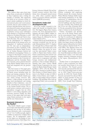
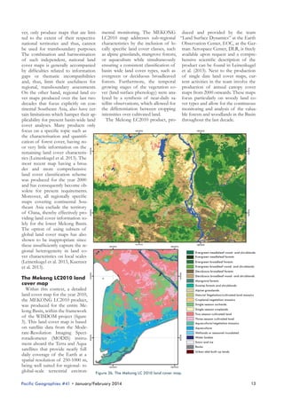
The Pacific Islands region comprises 22 states and dependent territories
dispersed over an area of 48 million
square kilometres with a total population of over 9 million people, approx.
7 million of whom live in Papua New
Guinea. All 14 independent states
of the region are developing or least
developed countries. Only Papua New

140°W

Tuvalu
Solomon Islands
Vanuatu

Tokelau
Wallis and
Futuna Samoa
American
Samoa

Fiji
New Caledonia

Niue Cook Islands

French Polynesia

Tonga
Pitcairn

A u s t r a l i a

40°

40°
0

New Zealand
140°E

180°

2000 km

140°W

Map 1: The Pacific Islands region (states and territories with their EEZ)

Pacific Geographies #41 • January/February 2014

5

Pacific Geographies Cartography: © Claus Carstens 2013

Guinea, Solomon Islands, Fiji and the velopment by awarding contracts to
Methods
The authors draw upon their expe- French overseas territory, New Cale- Chinese companies and employing
rience from several years of fieldwork donia, have substantial natural resour- Chinese citizens. By contrast, Samoan
in New Caledonia and a visiting fel- ces, while other countries depend Prime Minister Tuilaepa Sailele mentilowship in Australia. The arguments mainly on tourism, fisheries and remit- oned during celebrations of the 50th
anniversary of independence that he
are based on an extensive review of tances (MIRAB economies).
welcomed Chinese assistance to prorecent articles published in both the
vide the buildings and other infrastrucinternational press and social science Investment, trade and
ture that Australia, New Zealand and
journals, and on a great number of in- development aid
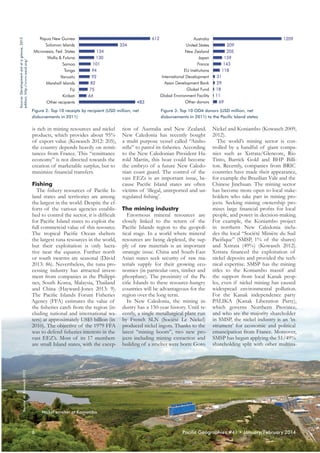
All of the smaller countries in the the US do not offer (Christian 2013:
terviews and discussions with local actors from civil society and government. region rely heavily on financial trans- 2). He also accused the US of showing
Empirical studies with qualitative and fers. The biggest, Papua New Guinea, a lack of interest in the South Pacific.
Chinese investment and developquantitative surveys were undertaken receives the most international devein the districts of Voh, Koné and Pou- lopment aid with US$612 million in ment aid in the Pacific Island states
embout in Northern Province, as well 2011 (28% of development aid to the can be overestimated. Figure 3 shows
as Noumea, Bourail and Yaté in Sou- region; Figure 2), followed by the So- the Top 10 contributors of official development assistance (ODA). With 1.2
thern Province. The surveys focussed lomon Islands (15%).
China’s trade in the South Pacific has USD billion (55% of total ODA), Auson the participation of indigenous
Kanak people in the mining sector, on increased sevenfold over the last de- tralia is the largest donor in the Pacific
integration of traditional authorities cade (Hayward-Jones 2013: 7). Impres- Islands region, followed by the United
into the state and on independence sive through this is, China’s trade with States and New Zealand (both 9% of
movements in New Caledonia. Colla- other parts in of the world, such as sub- total ODA). The diagram shows not
boration with Graeme Smith (Univer- Saharan Africa, has grown by more only state donors, but also internatisity of Sydney Business School) led over the same period. Trade is most onal funding organisations, such as
to fieldwork investigating Chinese in- visible in Papua New Guinea where the Asian Development Bank and the
vestment in this French overseas terri- China is interested in that nation’s vast Global Fund. China is far from chaltory. Discussions with researchers and mineral resources. Chinese companies lenging Australia’s dominant position
doctoral students at the University of often work in cooperation with other in the region (Hayward-Jones 2013:
Melbourne and the Australian Natio- foreign investors and multinational 11).
Another form of development aid,
nal University about general interests partners so that it remains difficult to
in the Pacific Islands region were ana- quantify their share. China’s Metall- which is often overlooked, are finanlysed and integrated into the present urgical Group Corporation has inves- cial transfers from France to its overted in the Ramu Nickel Project. Smith seas territories. The French governarticle.
The first section of the paper gives highlights (2013: 178) the Ramu Ni- ment recently announced that this was
an overview of the economic interests ckel mine, situated in northern Papua one of the only budget items to increof Pacific actors, including trade, fis- New Guinea, as China’s largest invest- ase in 2013 (http://www.outre-mer.
heries and mining extraction. The mi- ment in the Pacific to date, at US$1.4 gouv.fr). In 2010, the French Public
neral resources in Pacific Island coun- billion. Some Chinese aid is highly vi- Treasury accounted for about US$1.4
tries attract foreign investors. The sible as roads, bridges and government billion of fiscal transfers in New Caauthors – while working on state buil- buildings. Aid spending often ends up ledonia (US$5815 per capita, ISEE
ding, local development and mining supporting China’s own economic de- 2009). Even though New Caledonia
benefits in New Caledonia – were directly concerned by external interests
140°E
180°
Independent state
in the former French colony. The seUnited States
Hawaii Islands
New Zealand
cond section continues with actual inWake Island
France
Northern Mariana Islands
Johnston Atoll
dependence struggles that are often
Great Britain
Guam
Contested territory
linked to socio-ethnic disparities and
Marshall Islands
Recognizing China
economic interests. Finally, the third
Federated States
Recognizing Taiwan
Palmyra Island
Palau
of Micronesia
section of the paper deals with increTPP negotiations
Baker and Howland
0°
Independence movement
asing Chinese presence in the region 0°
Nauru Kiribati
Jarvis Island
Violent struggle
West Papua
Kiribati
and the new ‘Great Game’.
Papua
Kiribati
Source: Development aid at a glance, 2013
edition, http://www.oecd.org/

Figure 2: Top 10 receipts by recipient (USD million, net
disbursements in 2011)

is rich in mining resources and nickel
products, which provides about 95%
of export value (Kowasch 2012: 205),
the country depends heavily on remittances from France. This “remittance
economy” is not directed towards the
creation of marketable surplus, but to
maximize financial transfers.

Source: M. Kowasch 2012

Fishing
The fishery resources of Pacific Island states and territories are among
the largest in the world. Despite the efforts of the various agencies established to control the sector, it is difficult
for Pacific Island states to exploit the
full commercial value of this resource.
The tropical Pacific Ocean shelters
the largest tuna resources in the world,
but their exploitation is only lucrative near the equator. Further north
or south swarms are seasonal (David
2013: 86). Nevertheless, the tuna processing industry has attracted investment from companies in the Philippines, South Korea, Malaysia, Thailand
and China (Hayward-Jones 2013: 9).
The Pacific Islands Forum Fisheries
Agency (FFA) estimates the value of
the fisheries catch from the region (including national and international waters) at approximately US$5 billion (in
2010). The objective of the 1979 FFA
was to defend fisheries interests in the
vast EEZ’s. Most of its 17 members
are small Island states, with the excep-

Figure 3: Top 10 ODA donors (USD million, net
disbursements in 2011) to the Pacific Island states

tion of Australia and New Zealand. Nickel and Koniambo (Kowasch 2009,
New Caledonia has recently bought 2012).
The world’s mining sector is cona multi purpose vessel called “Amborella” to patrol its fisheries. According trolled by a handful of giant compato the New Caledonian President Ha- nies such as Xstrata/Glencore, Rio
rold Martin, this boat could become Tinto, Barrick Gold and BHP Billithe embryo of a future New Caledo- ton. Recently, companies from BRIC
nian coast guard. The control of the countries have made their appearance,
vast EEZs is an important issue, be- for example the Brazilian Vale and the
cause Pacific Island states are often Chinese Jinchuan. The mining sector
victims of ‘illegal, unreported and un- has become more open to local stakeholders who take part in mining proregulated fishing’.
jects. Seeking mining ownership promises large financial profits for local
The mining industry
Enormous mineral resources are people, and power in decision-making.
closely linked to the return of the For example, the Koniambo project
Pacific Islands region to the geopoli- in northern New Caledonia inclutical stage. In a world where mineral des the local “Société Minière du Sud
resources are being depleted, the sup- Pacifique” (SMSP, 1% of the shares)
ply of raw materials is an important and Xstrata (49%) (Kowasch 2012).
strategic issue. China and South-East Xstrata financed the exploitation of
Asian states seek security of raw ma- nickel deposits and provided the techterials supply for their growing eco- nical expertise. SMSP has the mining
nomies (in particular ores, timber and titles to the Koniambo massif and
phosphate). The proximity of the Pa- the support from local Kanak peopcific Islands to these resource-hungry les, even if nickel mining has caused
countries will be advantageous for the widespread environmental pollution.
For the Kanak independence party
region over the long term.
In New Caledonia, the mining in- PALIKA (Kanak Liberation Party),
dustry has a 150-year history. Until re- which governs Northern Province,
cently, a single metallurgical plant run and who are the majority shareholder
by French SLN (Société Le Nickel) in SMSP, the nickel industry is an ‘inproduced nickel ingots. Thanks to the strument’ for economic and political
latest “mining boom”, two new pro- emancipation from France. Moreover,
jects including mining extraction and SMSP has begun applying the 51/49%
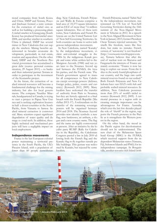
building of a smelter were born: Goro shareholding split with other multina-

Nickel smelter at Koniambo

6

Pacific Geographies #41 • January/February 2014
French Polynesia, named ‘Tahiti Nui’
tional companies from South Korea ding. New Caledonia, French Polyneand China. SMSP and Xstrata, Posco sia and Wallis & Futuna comprise a by the independence movement, was
and Jinchuan formed a joint venture land area of 23,373 square kilometres reinstated on UN List of Non-Selffor the extraction of nickel ores as and an EEZ of more than 7.6 million Governing Territories during the 16th
well as for building a processing plant. square kilometres. Two of these terri- summit of the Non-Aligned MoveA nickel smelter in Gwangyang (South tories, New Caledonia and French Po- ment in Teheran in 2012. In a speech
Korea) has produced ferronickel since lynesia are on the United Nations List to the Non-Aligned Movement in New
2008, and another smelter in southern of Non-Self-Governing Territories. In York in January 2013, former President
China is planned. SMSP has several both countries are home to active indi- Oscar Temaru rejected autonomy: “It
smells like freedom, tastes like freemines in New Caledonia that can sup- genous independence movements.
In New Caledonia, named ‘Kanaky’ dom, but make no mistake: French
ply the smelters. Mining benefits are
reinvested in broader economic de- by the independence movement, vi- version of ‘autonomy’ is not freedom.”
velopment, particularly in real estate, olent anti-colonial struggles in the (http://overseasreview.blogspot.com.
tourism and aquaculture. On the other 1980s by the indigenous Kanak peo- au). Temaru believes that after the
hand, SMSP and the Northern Pro- ple and some white settlers led to the end of nuclear tests on Mururoa and
vincial government has accumulated a Matignon Accords (1988) and ten ye- Fangataufa the interests of France are
great debt (source: personal commu- ars later to the Noumea Accord sig- mainly economic: “France is now lurnication, 29 August 2013) – to banks ned between the FLNKS, the loya- king to exploit our ocean. From the fiand their industrial partner Xstrata in list parties, and the French state. The shes to the newly found phosphates of
order to participate in the investment French government agreed to trans- our country, and the huge rare earth
fer all competences to New Caledo- mineral reserves found on our seabed.”
of the Koniambo project.
In the future, the extraction of se- nia except sovereign powers (defence, Both French Polynesia and New Caabed mineral resources will become a foreign policy, police, courts and cur- ledonia have vast EEZ’s with fish and
fundamental challenge for the mining rency) (Kowasch 2012, 2009). Many probable seabed mineral resources. In
industry, but also for local govern- loyalists have welcomed the transfer addition, New Caledonia possesses
ments. The company Nautilus Mine- of authority from Paris to Noumea, more than 25% of world’s nickel rerals, headquartered in Canada, is trying but they are fiercely opposed to a final sources (Kowasch 2012, 2009). A terto start a project in Papua New Gui- breach with the French Republic (Ma- ritorial presence in a region with innea and is seeking exploration licenses clellan 2013: 17). A referendum on the creasing strategic importance can be
in half a dozen countries in the South transfer of the remaining sovereign advantageous for France. Australia,
Pacific, from Vanuatu to Samoa. Se- powers will be organised between which over the last few decades played
abed mineral extraction is controver- 2014 and 2018. The Noumea Accord the role of ‘sheriff ’ in the region, supsial. Many scientists expect significant provides new identity symbols: a new ports the French presence in the Pacidegradation of water quality and da- flag, new banknotes, an anthem, a slo- fic as it strengthens the Western powmage to coral reefs. In addition, these gan and a new country name. The flag ers in the region.
On the other hand, the mood in
highly technical and mechanised pro- and the name are highly controversial
jects will have a negligible impact on at present. After an initiative by the lo- the Pacific region for decolonisation
yalist party RUMP (Rally for Caledo- should not be underestimated. The
local employment.
nia in the Republic), the Caledonian new chair of the Melanesian SpearCongress passed a law in July 2010 al- head Group (MSG) is the FLNKS,
Independence movements
France is the last European colonial lowing both the French flag and the which received support from the inpower maintaining a territorial pre- Kanaky flag to fly together outside pu- dependent Melanesian states (Vanuatu,
sence in the South Pacific, the UK’s blic buildings. This gesture was welco- Fiji, Solomon Islands and PNG) for its
Pitcairn Island, with a population of med by Kanaks, but rejected by some independence campaign. In Bougainville, another resource rich Island (with
fewer than 60 people notwithstan- loyalists.

Pacific Geographies #41 • January/February 2014

7
large copper resources), the peace process is nearing completion, and the decision on the final status of the Island
(autonomy status within PNG or creation of an independent state) will be
made soon. And in West Papua, with
the world’s largest gold mine, indigenous Papuan people continue to fight
for political independence from Indonesia.
The China challenge?
On November 27, 2011, U.S. President Barack Obama addressed the
Australian Parliament in Canberra to
announce a rebalancing in US foreign
politics: the political interest of the
United States is now focused more on
the Pacific Ocean than on the Middle
East. To maintain its hegemony in the
Pacific Ocean is one of its priorities.
Apart from military initiatives, economics and diplomacy will play an important role. Obama’s speech was followed by a paper published by the White
House entitled “Sustaining U.S. Global
Leadership: Priorities for 21st Century
Defence”. The document, released
in January 2012, mentions the general scarcity of natural resources in the
world. Then it elaborates on the apparent need to focus U.S. strategy on the
Asia-Pacific region. After ten years of
war against non-state actors, mainly in
Afghanistan and the Middle East, the
objective of American foreign policy
should now be focused on ‘containing’
China’s growing power. The United
States abandoned the ban on New Zealand ships docking in U.S. navy ports,

after reaching a deal with NZ ending
that country's ban on US nuclear powered vessels. Obama announced
that military aid to Indonesia will be
strengthened, a new military base in
Darwin opened, and the U.S. Navy
would increase its presence. Washington is working to extend its diplomatic relations with Indonesia, Vietnam
and the Philippines. Since 2010, negotiations have taking place between 12
states (including the US, Canada, Australia, New Zealand and Pacific Rim
states from Latin America and Asia)
for a Trans-Pacific Partnership, a proposal for a new multilateral free trade
agreement. China is excluded from the
negotiations. In summary, US strategy
seems to be focussed on South-East
Asia and the northern rim of the Pacific Islands region.
China for its part has embassies in
most of the Pacific Island states which
recognise the People’s Republic. Diplomats leverage Chinese contributions to development in the region
and expect support from Pacific Island governments for China’s international positions in return. In Tonga,
government officials rate outstanding
debt to China as nearly 30% of GDP
(IMF/World Bank Debt Sustainability Analysis 2010). From Micronesia
comes calls to relax visa requirements
for Chinese and Russians entering
these once US dominated territories
(Christian 2013: 1). Solo Mara, the
Fiji High Commissioner to the United
Kingdom, said on 6 March 2013 that
“China had filled a vacuum left when

the US and the UK withdrew and
which Australia did not adequately
fill” (http://pacificislandssociety.com).
China supports the Bainimarama regime in Fiji which is accused by Australia and the Pacific Islands Forum
of restoring democracy too slowly. It
is certain that China’s influence is rising. Crocombe (2007) suggests that
Pacific Island countries could shift allegiances from the Western Alliance
to Northeast Asia or ASEAN. On the
other hand, China has not yet sought
to project hard power into the Pacific
Islands region (Hayward-Jones 2013:
12). Rumours about China setting up
military bases in states have proven
unfounded. Its diplomatic and military
ties lag behind those of the other powers. Australia remains the key security
partner for most of the countries in
the region.
Prior to 2008, China’s interests in
the Pacific Islands were driven by its
competition with Taiwan for diplomatic recognition. Taiwan is recognized
by six states in the region: Kiribati,
Marshall Islands, Nauru, Palau, Solomon Islands and Tuvalu (see figure
1). So-called “chequebook diplomacy”
ended when Taiwanese President Ma
Ying-jeou proposed a diplomatic truce
in 2008. Both Taiwan and China promised they would no longer seek to
persuade states that already recognised
the other to switch their recognition
(Hayward-Jones 2013: 6).
China’s increasing presence in the
Pacific has involved expanding trade,
investment and aid. China is an eco-

ASEAS

Österreichische Zeitschrift für Südostasienwissenschaften
Austrian Journal of South-East Asian Studies

An interdisciplinary peer-reviewed journal, covering cultural, social, economic, and political
aspects of South-East Asia from a contemporary and/or historical perspective.
Current Issues
ASEAS 6(1) Focus Social Movements
ASEAS 6(2) Focus Mobilities
Find more information
on www.seas.at

8

Upcoming Issues
ASEAS 7(1) Focus Conflict Dynamics & Transformations
ASEAS 7(2) Focus Imagining Indonesia
ISSN 1999-2521 (print)
1999-253X (online)

Pacific Geographies #41 • January/February 2014
nomic actor, but the Chinese govern- its investment more as cooperation.
ment has always been careful to say The proximity of the region to the rethat it is in competition. Chinese Vice- source-hungry Asian countries will be
Minister for Foreign Affairs, Cui Ti- advantageous over the long term for
ankai, tells journalists at the Pacific the Pacific Island states. Besides mineIslands Forum in Roratonga in 2012: ral resources, the great powers are ge“We are here in this region not to seek aring up to exploit the vast EEZs that
any particular influence, still less domi- shelter fish stocks and probable deep
nance. (…) China’s assistance to other sea resources. These may be the subdeveloping countries is in the frame- ject of frontier conflicts.
The question remains open whether
work of south-south cooperation so
our origin, our policy approach and the independent Pacific Island states
our practice are very different from may pursue a typical ‘Pacific Way’ in
those of the traditional donor coun- the new ‘Great Game’, which is based
tries” (http://news.xinhuanet.com). on consensus and open to all. In a peAccording to research conducted by riod of budget austerity, shifting alliBrant (2012), between 2006 and 2011 ances and partial commitments, PaciChina disbursed approx. US$850 mil- fic Island states want to play a bigger
lion in bilateral aid to the eight Paci- role on the international scene and defic Island states that recognise the termine their own economic partnerPeople’s Republic (not including scho- ships and political alliances. Pacific Islarships or technical assistance, which land states are no longer automatically
are delivered by separate government in the backyard of the former colonial states and several are still seeking
agencies in China).
political emancipation. Independence
movements, that are often forged by
Conclusion
Australia remains the principal eco- painful colonial histories, socio-econonomic partner for the Pacific Island mic disparities, and heteronymous restates. Nonetheless China’s increasing source exploitation, harness this drive
influence in the Pacific Islands region for emancipation. The desire for poliis driven by economic interests; the tical sovereignty is alive, and is likely to
country looks for security of supply be made by referendums rather than
of minerals and timber for its gro- violent struggles.
wing economy. Chinese investment in
the Pacific Islands region – where it is Acknowledgement
The authors are deeply grateful to
mostly welcomed – is most visible in
resource-rich Papua New Guinea. The Simon Batterbury, John Burton and
Chinese government does not aim for Graeme Smith for advice, assistance
supremacy in the region, and defines and comments.

References
Brant, P. (2012). No strings attached? Chinese
foreign aid and its implications for the international
aid regime, PhD, The University of Melbourne
Callick, R. (2009). China and Taiwan end war
over Pacific aid. The Australian, 10 August 2009.
Christian, P. (2012). Patriot Games: Island voices
in a sea of contest. Pacific Institute of Public Policy,
Paper Discussion 21, June 2012
Crocombe, R. (2007). Asia in the Pacific Islands:
Replacing the West, Suva, University of the South
Pacific, IPS Publications
David, G. (2013). In Larcher, S.: La France dans
le Pacifique: Quelle vision pour le 21ième siècle?
Colloque du 17 janvier 2013, Délégation Sénatoriale à l’Outre-Mer, N° 293, 83-88
Garnaut, J. (2013). China muscles US in Pacific.
The Age, 16 February 2013
Haas, M. (1991). The Pacific Way: Regional Cooperation in the South Pacific. Pacific Studies, Vol.
14, No. 2, 194-196
Hayward-Jones, J. (2013). Big enough for all of us:
Geo-strategic competition in the Pacific Islands. Low
Institute for International Policy, May 2013
IMF/World Bank Debt Sustainability Analysis 2010, http://imf.org/external/pubs/ft/dsa/pdf/
dsacr10112.pdf
Kowasch, M. (2012). Le développement de
l'industrie du nickel et la transformation de la
valeur de l'environnement en Nouvelle Calédonie.
Journal of Political Ecology 19, 202-220. http://jpe.
library.arizona.edu/volume_19/Kowasch.pdf
Kowasch, M. (2009). Neukaledonien zwischen
Staatenbildung und Ressourcenaus-beutung – Neue
Nickelprojekte als Hebel für einen politischen Emanzipierungsprozess und zum Abbau von Disparitäten?
Pacific News, Jul-Aug: 8-11, http://www.pacificnews.de/pn32/pn32_kowasch.pdf
Maclellan, N. (2013). Politics heats up in New
Caledonia. Islands Business, February 2013, 17-20
Smith, G. (2013). Nupela Masta? Local and
Expatriate Labour in a Chinese-Run Nickel Mine
in Papua New Guinea. Asian Studies Review, 37:2,
178-195

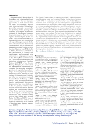
Source: M. Kowasch 2013

Corresponding author: Dr. Matthias Kowasch [matthias.kowasch@ird.fr] is currently a postdoctoral
researcher at the French Institute of Research for Development (IRD), based in Northern Province
of New Caledonia.

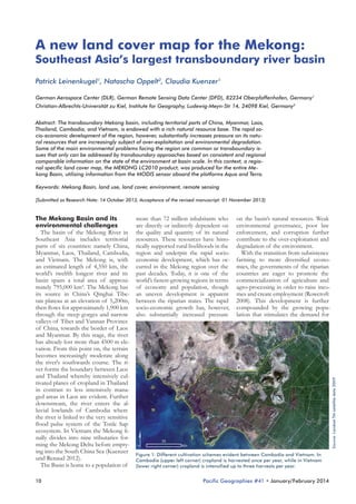
Poro Nickel Mine (New Caledonia)

Pacific Geographies #41 • January/February 2014

9
A new land cover map for the Mekong:

Southeast Asia’s largest transboundary river basin
Patrick Leinenkugel1, Natascha Oppelt2, Claudia Kuenzer1
German Aerospace Center (DLR), German Remote Sensing Data Center (DFD), 82234 Oberpfaffenhofen, Germany1
Christian-Albrechts-Universität zu Kiel, Institute for Geography, Ludewig-Meyn-Str 14, 24098 Kiel, Germany2
Abstract: The transboundary Mekong basin, including territorial parts of China, Myanmar, Laos,
Thailand, Cambodia, and Vietnam, is endowed with a rich natural resource base. The rapid socio-economic development of the region, however, substantially increases pressure on its natural resources that are increasingly subject of over-exploitation and environmental degradation.
Some of the main environmental problems facing the region are common or transboundary issues that only can be addressed by transboundary approaches based on consistent and regional
comparable information on the state of the environment at basin scale. In this context, a regional specific land cover map, the MEKONG LC2010 product, was produced for the entire Mekong Basin, utilising information from the MODIS sensor aboard the platforms Aqua and Terra.
Keywords: Mekong Basin, land use, land cover, environment, remote sensing
[Submitted as Research Note: 14 October 2013, Acceptance of the revised manuscript: 01 November 2013]

10

more than 72 million inhabitants who
are directly or indirectly dependent on
the quality and quantity of its natural
resources. These resources have historically supported rural livelihoods in the
region and underpin the rapid socioeconomic development, which has occurred in the Mekong region over the
past decades. Today, it is one of the
world’s fastest-growing regions in terms
of economy and population, though
an uneven development is apparent
between the riparian states. The rapid
socio-economic growth has, however,
also substantially increased pressure

on the basin’s natural resources. Weak
environmental governance, poor law
enforcement, and corruption further
contribute to the over-exploitation and
degradation of the environment.
With the transition from subsistence
farming to more diversified economies, the governments of the riparian
countries are eager to promote the
commercialization of agriculture and
agro-processing in order to raise incomes and create employment (Rowcroft
2008). This development is further
compounded by the growing population that stimulates the demand for

Source: Landsat TM satellite data 2009

The Mekong Basin and its
environmental challenges
The basin of the Mekong River in
Southeast Asia includes territorial
parts of six countries: namely China,
Myanmar, Laos, Thailand, Cambodia,
and Vietnam. The Mekong is, with
an estimated length of 4,350 km, the
world’s twelfth longest river and its
basin spans a total area of approximately 795,000 km². The Mekong has
its source in China’s Qinghai Tibetan plateau at an elevation of 5,200m,
then flows for approximately 1,900 km
through the steep gorges and narrow
valleys of Tibet and Yunnan Province
of China, towards the border of Laos
and Myanmar. By this stage, the river
has already lost more than 4500 m elevation. From this point on, the terrain
becomes increasingly moderate along
the river's southwards course. The river forms the boundary between Laos
and Thailand whereby intensively cultivated planes of cropland in Thailand
in contrast to less intensively managed areas in Laos are evident. Further
downstream, the river enters the alluvial lowlands of Cambodia where
the river is linked to the very sensitive
flood pulse system of the Tonle Sap
ecosystem. In Vietnam the Mekong finally divides into nine tributaries forming the Mekong Delta before emptying into the South China Sea (Kuenzer
und Renaud 2012).
The Basin is home to a population of

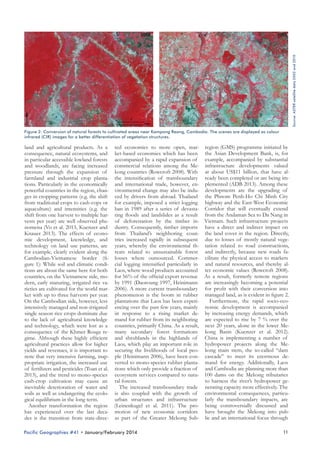
Figure 1: Different cultivation schemes evident between Cambodia and Vietnam. In
Cambodia (upper left corner) cropland is harvested once per year, while in Vietnam
(lower right corner) cropland is intensified up to three harvests per year.

Pacific Geographies #41 • January/February 2014
Source: ASTER satellite data 2002 and 2010

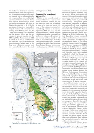
Figure 2: Conversion of natural forests to cultivated areas near Kampong Reang, Cambodia. The scenes are displayed as colour
infrared (CIR) images for a better differentiation of vegetation structures.

land and agricultural products. As a ted economies to more open, mar- region (GMS) programme initiated by
consequence, natural ecosystems, and ket-based economies which has been the Asian Development Bank, is, for
in particular accessible lowland forests accompanied by a rapid expansion of example, accompanied by substantial
and woodlands, are facing increased commercial relations among the Me- infrastructure developments valued
pressure through the expansion of kong countries (Rowcroft 2008). With at about US$11 billion, that have alfarmland and industrial crop planta- the intensification of transboundary ready been completed or are being imtions. Particularly in the economically and international trade, however, en- plemented (ADB 2013). Among these
powerful countries in the region, chan- vironmental change may also be indu- developments are the upgrading of
ges in cropping patterns (e.g. the shift ced by drivers from abroad. Thailand the Phnom Penh-Ho Chi Minh City
from traditional crops to cash-cops or for example, imposed a strict logging highway and the East-West Economic
aquaculture) and intensities (e.g. the ban in 1989 after a series of devasta- Corridor that will eventually extend
shift from one harvest to multiple har- ting floods and landslides as a result from the Andaman Sea to Da Nang in
vests per year) are well observed phe- of deforestation by the timber in- Vietnam. Such infrastructure projects
nomena (Vo et al. 2013, Kuenzer and dustry. Consequently, timber imports have a direct and indirect impact on
Knauer 2013). The effects of econo- from Thailand’s neighboring coun- the land cover in the region. Directly,
mic development, knowledge, and tries increased rapidly in subsequent due to losses of mostly natural vegetechnology on land use patterns, are years, whereby the environmental th- tation related to road constructions,
for example, clearly evident along the reats related to unsustainable forest and indirectly, because new roads faCambodian-Vietnamese border (fi- losses where outsourced. Commer- cilitate the physical access to markets
gure 1): While soil and climatic condi- cial logging intensified particularly in and natural resources, and thereby altions are about the same here for both Laos, where wood products accounted ter economic values (Rowcroft 2008).
countries, on the Vietnamese side, mo- for 56% of the official export revenue As a result, formerly remote regions
dern, early maturing, irrigated rice va- by 1991 (Daoroung 1997, Heinimann are increasingly becoming a potential
rieties are cultivated for the world mar- 2006). A more current transboundary for profit with their conversion into
ket with up to three harvests per year. phenomenon is the boom in rubber managed land, as is evident in figure 2.
Furthermore, the rapid socio-ecoOn the Cambodian side, however, less plantations that Laos has been experiintensively managed and non-irrigated encing over the past few years, mainly nomic development is accompanied
single season rice crops dominate due in response to a rising market de- by increasing energy demands, which
to the lack of agricultural knowledge mand for rubber from its neighboring are expected to rise by 7 % over the
and technology, which were lost as a countries, primarily China. As a result, next 20 years, alone in the lower Meconsequence of the Khmer Rouge re- many secondary forest formations kong Basin (Kuenzer et al. 2012).
gime. Although these highly efficient and shrublands in the highlands of China is implementing a number of
agricultural practices allow for higher Laos, which play an important role in hydropower projects along the Meyields and revenues, it is important to securing the livelihoods of local peo- kong main stem, the so-called “dam
note that very intensive farming, inap- ple (Heinimann 2006), have been con- cascade” to meet its enormous depropriate irrigation, the increased use verted to mono-species rubber planta- mand for energy. Additionally, Laos
of fertilizers and pesticides (Toan et al. tions which only provide a fraction of and Cambodia are planning more than
2013), and the trend to mono-species ecosystem services compared to natu- 100 dams on the Mekong tributaries
to harness the river’s hydropower gecash-crop cultivation may cause an ral forests.
The increased transboundary trade nerating capacity more effectively. The
inevitable deterioration of water and
soils as well as endangering the ecolo- is also coupled with the growth of environmental consequences, particuurban structures and infrastructure larly the transboundary impacts, are
gical equilibrium in the long term.
Another transformation the region (Leinenkugel et al. 2011). The pro- being controversially discussed and
has experienced over the last deca- motion of new economic corridors have brought the Mekong into pubdes is the transition from state-direc- as part of the Greater Mekong Sub- lic and an international focus through
Pacific Geographies #41 • January/February 2014

11
the media. The downstream countries,
believe that the dams are responsible
for the alteration to the overall flow of
the Mekong and its sedimentation. In
the long-term, these may result in high
environmental and social costs due to
bank erosion, water shortage, increased irrigation challenges, and shifts in
biodiversity (Kuenzer et al. 2012). In
particular, the dams are expected to
impede nutrient-rich sediment from
settling in the Mekong delta and the
Tonle Sap floodplain, which are essential for farming, fishery, and the prevention of saltwater intrusion into the
Mekong Delta (Kuenzer et al. 2012,
Kuenzer et al. 2013a). Furthermore,
the dams are expected to block fish
migration routes, which again, in the
long term, will increase pressure both
on cropland and areas for livestock

farming (Kuenzer 2013).
The need for a regional
perspective
Thanks to the shared natural resources and increased social and economic interactions between the riparian states, the basin can increasingly
be seen as an integrated region with
some of the main environmental problems being common or transboundary issues (UNEP and TEI). The Thai
logging ban or the Chinese dam cascade illustrate to what extent shifts in
land cover policies and practices in
one country, can lead directly or indirectly to profound changes in another
country’s natural resources, economic
conditions, or political and economic
dependencies. Notably, however, the
very heterogenic political, economic,

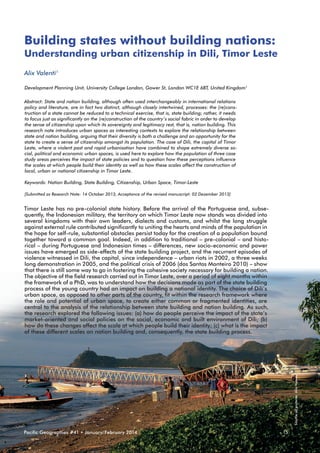
Figure 3a. The Mekong LC 2010 land cover map.

12

institutional, and cultural conditions
between the riparian countries have
led to very diverse perceptions and
practices in terms of natural resource
exploitation and conservation (Heiniman 2006). Therefore, coordinated,
trans-boundary management plans
that not only correspond to specific
environmental and social conditions
on local or national scales but also contribute towards a sustainable development of the entire Mekong region are
essential (Renaud and Kuenzer 2012,
Moder et al. 2012). Furthermore, the
inter-dependency between water, land,
and other related natural resources requires a perspective encompassing all
environmental aspects of the basin
following the principles of Integrated
Water Resource Management (IWRM)
(Moder et al. 2012). This is exemplified by the WISDOM Project, a bilateral research project between Germany
and Vietnam (http://www.wisdom.
eoc.dlr.de/), which has brought together more than 60 scientists from
the fields of hydrology, sociology, information technology, and earth observation aiming at the analysis of
socio-environmental issues in the Mekong Basin and the Mekong Delta, in
particular. The WISDOM project also
initiated the first transboundary conference on the Mekong Region- the
Mekong Environmental Symposium,
held in Ho Chi Minh City in March
2013, which highlighted the need for
consistent and regionally comparable
information on the state of the environment across all riparian countries.
A crucial information base that is
used to characterize the state of the
environment is provided by so-called
land cover maps which categorize and
quantify the environment according
to the discernible vegetation (e.g. forest, grassland), hydrologic (e.g. wetlands, water bodies) or anthropogenic
features (e.g. cropland, urban areas) on
the land surface. Generally, these land
cover maps are derived by the use of
satellite imagery and are essential to
many geo-scientific applications as
seen in the fields of agriculture, ecosystems, biodiversity, climate, health,
or energy. Furthermore, stakeholders,
decision makers, international organizations, research networks, donor
agencies, and others, require regional
land cover and land use maps as essential baseline information for reporting
and monitoring purposes.
Most government agencies, howe-

Pacific Geographies #41 • January/February 2014
ver, only produce maps that are limited to the extent of their respective
national territories and thus, cannot
be used for transboundary purposes.
The combination and harmonisation
of such independent, national land
cover maps is generally accompanied
by difficulties related to information
gaps or thematic incompatibilities
and, thus, limit their usefulness for
regional, transboundary assessments.
On the other hand, regional land cover maps produced over the last two
decades that focus explicitly on continental Southeast Asia, also have certain limitations which hamper their applicability for present basin-wide land
cover analyses. Many products only
focus on a specific topic such as
the characterisation and quantification of forest cover, having no
or very little information on the
remaining land cover characteristics (Leinenkugel et al. 2013). The
most recent map having a broader and more comprehensive
land cover classification scheme
was produced for the year 2000
and has consequently become obsolete for present requirements.
Moreover, all regionally specific
maps covering continental Southeast Asia exclude the territory
of China, thereby effectively providing land cover information solely for the lower Mekong Basin.
The option of using subsets of
global land cover maps has also
shown to be inappropriate since
these insufficiently capture the regional heterogeneity in land cover characteristics on local scales
(Leinenkugel et al. 2013, Kuenzer
et al. 2013).
The Mekong LC2010 land
cover map
Within this context, a detailed
land cover map for the year 2010,
the MEKONG LC2010 product,
was produced for the entire Mekong Basin, within the framework
of the WISDOM project (figure
3). This land cover map is based
on satellite data from the Moderate-Resolution Imaging Spectroradiometer (MODIS) instrument aboard the Terra and Aqua
satellites that provide nearly full
daily coverage of the Earth at a
spatial resolution of 250-1000 m,
being well suited for regional- to
global-scale terrestrial environ-

mental monitoring. The MEKONG duced and provided by the team
LC2010 map addresses sub-regional “Land Surface Dynamics” at the Earth
characteristics by the inclusion of lo- Observation Center, EOC, at the Gercally specific land cover classes, such man Aerospace Center, DLR, is freely
as alpine grasslands, mangrove forests, available upon request and a compreor aquaculture while simultaneously hensive scientific description of the
ensuring a consistent classification of product can be found in Leinenkugel
basin wide land cover types, such as et al. (2013). Next to the production
evergreen or deciduous broadleaved of single date land cover maps, curforests. Furthermore, the temporal rent activities in the team involve the
growing stages of the vegetation co- production of annual canopy cover
ver (land surface phenology) were ana- maps from 2000 onwards. These maps
lysed by a synthesis of near-daily sa- focus particularly on woody land cotellite observations, which allowed for ver types and allow for the continuous
the differentiation between cropping monitoring and analysis of the valuaintensities over cultivated land.
ble forests and woodlands in the Basin
The Mekong LC2010 product, pro- throughout the last decade.

Evergreen needleleaf wood- and shrublands
Evergreen needleleaf forests
Evergreen broadleaf forests
Evergreen broadleaf wood- and shrublands
Deciduous broadleaf forests
Deciduous broadleaf wood- and shrublands
Mangrove forests
Swamp forests and shrublands
Alpine grasslands
Natural Vegetation/cultivated land mosaics
Cropland/vegetation mosaics
Single season orchards
Single season croplands
Two season cultivated land
Three season cultivated land
Aquaculture/vegetation mosaics
Aquaculture
Wetlands or seasonel inundated
Water bodies
Snow and ice
Rocks
Urban abd built-up lands

Figure 3b. The Mekong LC 2010 land cover map.

Pacific Geographies #41 • January/February 2014

13
Conclusion
The transboundary Mekong Basin in
South East Asia is endowed with rich
natural resources that are increasingly subjected to much pressure from
the rapid socio-economic development within the region. Although geographically, culturally, economically
and politically diverse, growing transboundary trade and the increased exploitation of shared natural resources
have transformed the Basin into an integrated economic region. In this respect, it is inevitable that the Mekong riparian countries are keen to promote a
sub-regional dialog to maintain the balance between economic development
on the one hand, and the need for ecological protection and conservation on
the other (Kuenezer et al. 2012, Moder
et al 2012, Renaud and Kuenzer 2012).
The establishment of regional and
transboundary environmentally related institutions and programmes, such
as the Mekong River Commission or
the Core Environment Program and
Biodiversity Conservation Corridors
Initiative (CEP-BCI) of the Greater
Mekong Subregion, has shown that
the significance of transboundary cooperation for promoting sustainable
growth in the region has been acknowledged. However, regionally consistent
information on the state of the environment for the entire basin is still rare,
and either not accessible or outdated.
In view of this, the Mekong LC2010
product, being the only current basinspecific transboundary information
data set on the land cover distribution
in the area, provides scientists, stakeholders, and decision-makers with an
updated and comprehensive picture
of the diverse land cover characteristics of the region. As the first regional
specific land cover product covering
both the lower and the upper Mekong
Basin, the Mekong LC2010 map is
also of particular value for basin-wide
hydrological modeling in the context
of integrated water resource management (IWRM).

The Tibetan Plateau, where the Mekong originates, is predominantly covered by alpine grass- and rangeland. Below the tree line, at approximately 4000 m, needleleaved forest formations and shrubland become
dominant which increasingly give way to broadleaved evergreen forests
and woodlands, from elevations at 2000-2500m downwards. Particularly
in the more densely populated southern part of Yunnan province and northern Laos, however, large extents of these evergreen forests have been
degraded by small scale shifting cultivation practices, resulting in very heterogenic patterns forests and forest regrowth interspersed with patches of
shrub-, grass-, and cropland. The land cover distribution in the lowlands
of Laos and Cambodia shows lower proportions of evergreen vegetation
but higher distributions of cropland, cropland/vegetation mosaics, and
dry-deciduous broadleaved wood- and scrublands. Intensive cultivated
areas, mainly rice cultivation, are concentrated in the Mekong Delta, in
the lowlands surrounding Tonle Sap Lake, and in the extensive plains of
the Khorat Plateau in Thailand. In the Mekong Delta double- and tripleseason rice paddies, orchard cultivation, aquaculture, coastal mangrove
forests, and mixtures of the latter, known as integrated shrimp-mangrove
farming systems dominate.
Box 1: Land cover distribution in the Mekong Basin

References
ADB. (2013). Asian Development Bank. Greater Mekong Subregion website. http://www.adb.org/
countries/gms/sector-activities Accessed 06.09.2013
Daoroung, P. (1997). “Community Forests in Lao
PDR: The New Era of Participation?” Watershed 3
(1): 1–8.
Heinimann, A. (2006). “Patterns of Land Cover
Change in the Lower Mekong Basin.”
Kuenzer, C., Campbell, I., Roch, M., Leinenkugel,
P., Vo Quoc, T., & Dech, S. (2012). Understanding the impact of hydropower developments in the
context of upstream– downstream relations in the
Mekong River Basin. Sustainability Science.
Kuenzer, C., Guo, H., Huth, J., Leinenkugel, P.,
Li, X., & Dech, S. (2013a). Flood mapping and
flood dynamics of the Mekong Delta: ENVISAT–
ASAR–WSM based time series analyses. Remote
Sensing, 5, 687–715.
Kuenzer, C., Leinenkugel, P., Vollmuth, M., and
Dech, S. (2013b) Comparing Global Land Cover
Products – Implications for Geoscience Applications:
An Investigation for the trans-boundary Mekong
Basin. International Journal of Remote Sensing (in
review).
Kuenzer, C., & Knauer, K. (2013). Remote sensing of rice crop areas. International Journal of
Remote Sensing, 34, 2101–2139.
Kuenzer, C. (2013). Field Note: Threatening
Tonle Sap: Challenges for Southeast-Asia’s largest
Freshwater Lake, The Pacific Geographies, 29-31.
Leinenkugel, P., Esch, T., & Kuenzer, C. (2011).

Settlement detection and impervious surface estimation in the Mekong delta using optical and SAR data.
Remote Sensing of Environment, 115, 3007–3019.
Leinenkugel, P., Kuenzer, C., Oppelt N., & Dech,
S. (2013). Characterisation of Land Surface Phenology and Land Cover Based on Moderate Resolution
Satellite Data in Cloud Prone Areas — A Novel
Product for the Mekong Basin. Remote Sensing of
Environment, 136, 180–198.
Moder, F., Kuenzer, C., Xu, Z., Leinenkugel, P., &
Bui Van, Q. (2012). IWRMfor theMekong Basin.
In: F. Renaud, & C. Kuenzer (Eds.), The Mekong
Delta system — Interdisciplinary analyses of a river
delta, pp. 133–166, Springer.
Rowcroft, P. (2008). Frontiers of Change: The Reasons Behind Land-use Change in the Mekong Basin.
AMBIO, 37, 213–218.
Toan, P.V., Sebesvari, Z., Bläsing, M., Rosendahl,
I., & Renaud, F.G. (2013). Pesticide management
and their residues in sediments and surface and
drinking water in the Mekong Delta, Vietnam. In:
Science of the Total Environment, 452–453, 28-39.
UNEP and TEI , United Nations Environment
Programme and Thailand Environment Institute. (2007). Greater Mekong Environment Outlook
2007. Bangkok.
Vo, Q. T., Oppelt, N., Leinenkugel, P., Kuenzer
C. (2013). Remote Sensing in Mapping Mangrove
Ecosystems — An Object-Based Approach. Remote
Sensing, 5, 183-201.
Renaud, F. & Kuenzer, C. (2012): The Mekong
Delta System - Interdisciplinary Analyses of a River
Delta. Springe.

Corresponding author: Patrick Leinenkugel [patrick.leinenkugel@dlr.de] has received his Master in
Applied Geoinformatics from the University of Salzburg in 2010. Currently, he is working on his PhD
at the Earth Observation Center (EOC) at the German Aerospace Center (DLR), focusing on the
analysis of land cover dynamics in the Mekong Basin by remote sensing methodologies.

14

Pacific Geographies #41 • January/February 2014
Building states without building nations:
Understanding urban citizenship in Dili, Timor Leste
Alix Valenti1
Development Planning Unit, University College London, Gower St, London WC1E 6BT, United Kingdom1
Abstract: State and nation building, although often used interchangeably in international relations
policy and literature, are in fact two distinct, although closely intertwined, processes: the (re)construction of a state cannot be reduced to a technical exercise, that is, state building; rather, it needs
to focus just as significantly on the (re)construction of the country’s social fabric in order to develop
the sense of citizenship upon which its sovereignty and legitimacy rest, that is, nation building. This
research note introduces urban spaces as interesting contexts to explore the relationship between
state and nation building, arguing that their diversity is both a challenge and an opportunity for the
state to create a sense of citizenship amongst its population. The case of Dili, the capital of Timor
Leste, where a violent past and rapid urbanisation have combined to shape extremely diverse social, political and economic urban spaces, is used here to explore how the population of three case
study areas perceives the impact of state policies and to question how these perceptions influence
the scales at which people build their identity as well as how these scales affect the construction of
local, urban or national citizenship in Timor Leste.
Keywords: Nation Building, State Building, Citizenship, Urban Space, Timor-Leste
[Submitted as Research Note: 14 October 2013, Acceptance of the revised manuscript: 02 Dezember 2013]

Source all pictures: Alix Valenti

Timor Leste has no pre-colonial state history. Before the arrival of the Portuguese and, subsequently, the Indonesian military, the territory on which Timor Leste now stands was divided into
several kingdoms with their own leaders, dialects and customs, and whilst the long struggle
against external rule contributed significantly to uniting the hearts and minds of the population in
the hope for self-rule, substantial obstacles persist today for the creation of a population bound
together toward a common goal. Indeed, in addition to traditional – pre-colonial – and historical – during Portuguese and Indonesian times – differences, new socio-economic and power
issues have emerged as side-effects of the state building project, and the recurrent episodes of
violence witnessed in Dili, the capital, since independence – urban riots in 2002, a three weeks
long demonstration in 2005, and the political crisis of 2006 (dos Santos Monteiro 2010) – show
that there is still some way to go in fostering the cohesive society necessary for building a nation.
The objective of the field research carried out in Timor Leste, over a period of eight months within
the framework of a PhD, was to understand how the decisions made as part of the state building
process of the young country had an impact on building a national identity. The choice of Dili’s
urban space, as opposed to other parts of the country, fit within the research framework where
the role and potential of urban space, to create either common or fragmented identities, are
central to the analysis of the relationship between state building and nation building. As such,
the research explored the following issues: (a) how do people perceive the impact of the state’s
market-oriented and social policies on the social, economic and built environment of Dili; (b)
how do these changes affect the scale at which people build their identity; (c) what is the impact
of these different scales on nation building and, consequently, the state building process.

Pacific Geographies #41 • January/February 2014

15
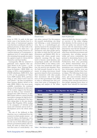
Source: Census Atlas, 2004, p. 31. Cartography: © Arne Löprick 2013

ted through the lens of social contract
The relationship between
theory, is underpinned by the notion
state and nation building
Although international relations li- of citizenship – both relational and
terature and policies often use the juridico-legal. Indeed, citizenship in
terms ‘state building’ and ‘nation buil- its relational sense is ‘linked to various
ding’ interchangeably, an overview of notions of identity, attained through
the relationship between ‘state’ and action, not only vis-à-vis the state, but
‘nation’ demonstrates that they are, in in other sites of politics as well, be
reality, two distinct though intercon- they in the home, acts of cultural resisnected processes. The use of social tance or social movements’ (Gaventa
contract theory is very useful here to 2006), and is at the heart of how the
understand that states do not emerge nation is formed. Nonetheless, as noin a vacuum; rather, states are the pro- ted above, the ability to maintain these
duct of a group of people, within relations lies within the state and is
a given space, that choose to form ensured through the fair implementaa body politic where the protection tion of rights – protection – and duof a community’s interests is consi- ties – common values and civic culture
dered more just than everyone pro- – that is through juridico-legal citizentecting their personal interests, and ship. Consequently, a state’s sustainabiwhere these interests are protected lity resides in the quality of its citizens’
by a government, the form of which interaction on a daily basis, and whilst
is chosen by the community (Locke these interactions take place at the lo1952; Rousseau 1923). The emergence cal level within a variety of spaces, it is
of the body politic, commonly refer- the capacity of the state to foster good
red to as the nation, is therefore at relations between these spaces, where
the basis of state sovereignty and re- communities emerge, that enables it to
quires a constant negotiation of diffe- create a wider national social identity,
rent identities and interests in order to extending state sovereignty and legitiform one common social identity. As macy over a wider territory.
In the context of state and nation
such, the ability of the state to remain
in power, once formed, resides in its building, however, the relationship decapacity to build adequate institutions scribed above has been undermined
that facilitate the dialogue necessary by the introduction of an external elefor these negotiations, for if the state ment: international assistance for (re)
is perceived as promoting unjustly building “functioning and durable stasome interests over others, common tes capable of fulfilling the essential atwill to be governed by this state is un- tributes of modern statehood” (Dindermined and a new body politic can nen 2007). State building has implied
emerge. This capacity is what is com- that sovereignty is now conferred to
the state by international organisamonly referred to as state legitimacy.
The relationship between state so- tions through the fulfilment of certain
vereignty and legitimacy, as articula- priorities, whilst legitimacy is gained

Dili
Liquica

Aileu

Baucau
Manatuto

Ermera
Bobonaro

Lautem

Viqueque

Manufahi

Anaro

Net Migration, Lifetime
Oecusse

Covalima

Net Lifetime Migration to Dili
12.000
6.000
2.000

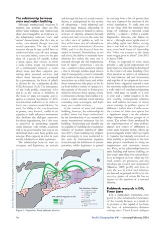
Figure 1: Population flows between districts

16

-10.218 to -7.631
-7.630 to -3.440
-3.439 to 0
1 to 586
71.480
District Boundary
Indonesia
Major Urban Center
Road

by electing from a list of parties that
may not represent the interests of the
whole population. As such, new states are faced with the immense challenge of building a national social
identity – a nation – within a socially
fragmented citizenry, and failure to
do so – through unjust application of
citizenship rights and duties, corruption – can lead to the emergence of
new, more local forms of citizenship
that “often run counter to the dominant images given to them” (Isin 2002
in Secor 2004).
Cities, as opposed to rural areas,
provide a very good opportunity for
analysing how citizenship is developed
in the context of state building. First,
their position as centres of attraction
for international aid and investment,
and as poles of development for a new
labour force organised around a market economy, makes them attractive to
a wide variety of population migrating
from rural areas in search of a role
to play and a better situation in the
new country. Consequently, urbanisation and sudden increases in investment converge to produce spaces of
difference within cities. Furthermore,
the creation of these new spaces has
a significant impact on the relationships between different groups of citizens. The urban fabric produced by
the implementation of state policies
creates new spaces of difference as
some areas become richer, others appear to stagnate whilst others yet seem
to become increasingly ostracised as
their inability to participate to the new
state project contributes to rising unemployment and economic insecurity. Thus, in the relationship between
state building and nation building, urban spaces articulate how state policies
have an impact on how ‘ideas are formed, actions are produced, and relationships are created and maintained’
(Marston, 2005; p.427) and how, in
turn, the way in which such relations
are framed, organised and lived in the
everyday spaces of urban life has an
impact on the creation of a national
identity.
Fieldwork research in Dili,
Timor Leste
Dili is particularly interesting compared to other urbanised or rural areas
of the country because, as a result of
its position as the capital, it has been
the heart of administrative decisionmaking since Timor Leste’s indepen-

Pacific Geographies #41 • January/February 2014
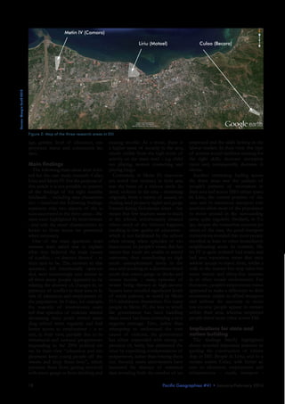
Church in Liriu

Metin IV police post

dence in 1999. As such, in the past cal, urban, national. For this purpose, spaces in which they interact, to gather
twelve years it has become host to a the research methodology was desig- an overview of the milieu shaping
wide variety of international organisa- ned following a social constructivist their identities. In this context, no spetions that have contributed, with the si- view, that is, a methodological per- cific state policy was selected for disgnificant presence of their staff, to the spective based on the assumption that cussion with the interviewees; rather,
development of the urban area – e.g. people’s identities are shaped by their interviewees were left the freedom to
infrastructure, housing, businesses, etc interactions with other people and by highlight what they believed to be the
– and has attracted, as a consequence, a the milieu in which they live and work main issues with their government and
significant level of rural-urban migra- (Finnemore and Sikkink 2001). By in- community, thus revealing patterns
tion stemming from people moving to teracting with others, people create within and across communities that
the capital in search of a better life for subjective meanings that are negot- pointed to determining factors in the
iated to become social identities, and construction of their social identity.
themselves and their families.
Consequently, Dili has attracted si- renegotiated socially and historically Furthermore, three areas presenting
gnificantly more migrants than any (Creswell 2009) as new milieux come very distinct characteristics were seother district in the country – as the to create new interactions and, there- lected in order to ensure that people’s
2004 statistics show (National Direc- fore, the need for new identities. Thus, perceptions were constructed in diffetorate for Statistics – DNE 2004) – re- the field research focused on two ele- rent environments and, by cross anaaching, in 2010, a total population of ments: (a) asking interviewees broad lysing, investigate whether these have
234,026 inhabitants (NDS 2013), that questions related to their environment, an impact. The following criteria were
is 21% of the population of Timor their interactions with other people, chosen: history of violence, developLeste (NDS website 2013), and beco- their movements and their percep- ment, and socio-economic characteming, as such, Timor Leste’s most di- tions of their governments since 2002, ristics. Finally, the research aimed at
verse district – the data on population in order to understand how they con- ensuring variety amongst interviewees,
flows between districts shown in the struct their sense of belonging; (b) a thus people spanning across these catable (DNE 2004) is the most recent mapping and analysis of the urban tegories were selected for interviews:
available, nonetheless the continued
absence of development in other areas
% Living in
of the country suggests that these patDistrict
In- Migration Out- Migration Net- Migration
District of Birth
terns are likely to have remained unchanged since 2004. However, to date
Baucau
5,692
15,91
-10,218
94
Dili remains without a master developViqueque
3,727
12,845
-9,118
94
ment plan to manage the high levels of
migration and urbanisation that have
Bobonaro
4,853
12,484
-7,631
94
been taking place in the past decade
Lautem
1,726
6,515
-4,789
97
(Soares Reis Pequinho 2010), leading
Manatuto
2,92
7,113
-4,193
92
to the emergence of informal settlements and extremely uneven levels of
Ainaro
4,137
8,111
-3,974
89
development across the whole urban
Ermera
6,223
9,663
-3,44
94
area.
Liquiçà
3,879
5,505
-1,626
93
The aim of the fieldwork in Dili,
therefore, was to understand how the
Aileu
6,117
7,452
-1,335
84
contexts in which people interact – afManufahi
4,975
5,324
-349
89
fected by history, development, socioCovalima
4,942
4,785
157
91
economic differences and conflict – afOecusse
3,094
2,508
586
95
fect the way in which different groups
perceive government policies and, as a
Dili
79,757
8,277
71,48
54
result, the scales at which they construct their sense of social identity – lo- Table 1: Net lifetime migration, by District
Pacific Geographies #41 • January/February 2014

17

Source: Census Atlas, 2004; p.30

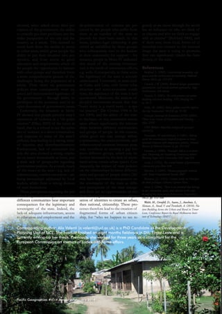
Culao
Metin IV (Comoro)
Culao (Becora)

Source: Google Earth 2013

Liriu (Motael)

Figure 2: Map of the three research areas in Dili

age, gender, level of education, employment status and community leaders.
Main findings
The following three areas were selected for the case study research: Culao,
Liriu and Metin IV. For the purpose of
this article it is not possible to present
all the findings of the eight months
fieldwork – including area characteristics – therefore the following findings
represent only two aspects of the issues uncovered in the three areas – the
ones most highlighted by interviewees
– and only the areas’ characteristics relevant to those issues are presented
when necessary.
One of the main questions interviewees were asked was to explain
what they believed the main causes
of conflict – or absence thereof – in
their area to be. The answers to this
question, left intentionally open-ended, were interestingly very similar in
all three areas: people appeared to be
relating the absence of, changes in, or
presence of conflict in their area to levels of education and employment of
the population. In Culao, for example,
the majority of interviewees asserted that episodes of violence started
decreasing since youth started attending school more regularly and had
better access to employment – a result, in their view, partially due to international and national programmes
responding to the 2006 political crisis. In their view “education and employment keep young people off the
streets and keep them busy”, which
prevents them from getting involved
with street gangs or from drinking and
18

causing trouble. As a result, there is employed and the skills lacking in the
a higher sense of security in the area, labour market. In their view, this type
clearly visible from the high levels of of actions would facilitate training for
activity on the main road – e.g. child- the right skills, decrease unemployren playing, women interacting and ment and, consequently, decrease violence.
playing bingo.
Another interesting finding across
Conversely, in Metin IV, interviewees noted that violence in their area the three areas was the analysis of
was the heart of a vicious circle. In- people’s patterns of movement in
deed, violence in the area – stemming their area and across Dili’s urban space.
originally from a variety of causes, in- In Liriu, the central position of the
cluding land property rights and gangs area and its numerous transport conformed during Indonesian times – has nections allow most of the population
meant that few teachers want to teach to move around in the surrounding
in the school, unfortunately situated areas quite regularly. Similarly, in Cuwhere much of the violence happens, lao, despite the somewhat external poresulting in low quality of education – sition of the area, the good transport
which is not facilitated by the school connections revealed that most people
often closing when episodes of vio- travelled at least to other immediately
lence occur. In people’s views, this has neighbouring areas. In contrast, Memeant that youth are unable to attend tin IV is quite isolated: bad roads and
university, thus contributing to high bad area reputation mean that taxis
youth unemployment levels in the seldom accept to travel there, whilst a
area and resulting in a disenfranchised walk to the nearest bus stop takes betyouth that enters gangs or drinks and ween twenty and thirty-five minutes
causes trouble – many episodes of in an often unsafe environment. Furstones being thrown at high-income thermore, people’s employment status
houses have revealed significant levels appeared to make a difference to their
of social jealousy, as noted by Metin movement: unable to afford transport,
IV’s inhabitants themselves. For many and without the necessity to move,
people in Metin IV, the way in which low-income people appear to remain
the government has been handling within their area, whereas employed
these issues has been conveying a very people travel more often across Dili.
negative message. First, rather than
attempting to understand the root Implications for state and
causes of violence, the government nation building
The findings briefly highlighted
has either responded with strong repression or, lately, has addressed the above revealed important patterns reissue by expediting condemnations of garding the construction of citizenperpetrators, rather than hearing them ship in Dili. People in Liriu, and to a
out. Second, many interviewees have certain extent Culao, with better aclamented the absence of statistical cess to education, employment and
data revealing both the number of un- infrastructure – roads, transport –
Pacific Geographies #41 • January/February 2014
showed, when asked about their per- de-politicisation of violence are perception of the government, the ability ceived by the people who suffer from
to critically put their problems into the them as an inability of the state to
wider perspective of the city and the provide for their basic needs. In this
country as a whole. This seemed to sense, juridico-legal citizenship is perresult both from the facility to move ceived as unfulfilled by these groups,
to other areas, which gives people the who subsequently turn to the leaders
ability to put their situation into per- in their community for support – for
spective, and from access to good instance, people in Metin IV indicated
education and employment, which of- that much of the existing infrastrucfer people the opportunity to interact ture is the result of community efforts,
with other groups and therefore form e.g. wells. Consequently, in these areas
a more comprehensive picture of the the legitimacy of the state is severely
challenges facing the population as a undermined. Conversely, in areas such
whole. Their views on government as Culao and Liriu, with better infrapolicies were consequently more nu- structure and socio-economic condianced and demonstrated legitimacy of tions, the legitimacy of the state is less
the government – through ability to questioned. Moreover, the analysis of
participate in the economy and/or in people’s movements reveals that that
open discussion of government issues. “every story is a travel story – a spaConversely, the situation in Metin tial practice” (De Certeau 1984 in SeIV showed that people perceive state’s cor 2004), and the ability of the state
repression of violence as a “de-politi- to facilitate, or not, movement across
cisation” (Dikeç 2002) of the issues at areas affects significantly the relationhand, that is, a refusal to see the episo- ships between different communities
des of violence as a direct contestation and groups of people. In this context,
and response to some of the state’s whilst good ties may emerge within
policies, thus leading to a strong sense communities, the socio-economic and
of injustice and disenfranchisement. infrastructural contrasts between areas
Furthermore, lack of movement out- may contribute to creating a gap betside the area showed a strong empha- ween different groups, which may be
sis on issues immediately at hand, and further increased by the lack of movea stark lack of perspective regarding ment across certain urban spaces. Congovernment policies. As a result, much sequently, the impact of state policies
of the issues in the area – e.g. lack of on the relationships between different
infrastructure, conflict resolution – are areas and groups of people within Dili
being increasingly addressed by local may have important consequences on
leaders, whilst there is strong distrust the sovereignty of the state as different perceptions of the state emerge
of state institutions.
These perceptions regarding the per- and there are no opportunities or meceived impact of state policies within chanisms in place to foster a renegotdifferent communities bear important iation of identities to create an urban,
consequences for the legitimacy and then national, citizenship. These prosovereignty of the state. Indeed, the cesses therefore lead to the creation of
lack of adequate infrastructure, access fragmented forms of urban citizento education and employment and the ship, for “who we happen to see re-

gularly as we move through the world
has an influence on who we think of
as citizens and who we think to engage
with as citizens” (Bickford 2000); and
if these new, more local, forms of citizenship run counter to the national
image the state is trying to promote,
they can significantly hinder the functioning of the state.
References
Bickford, S. (2000), Constructing inequality: city
spaces and the architecture of citizenship, Political
Theory, 28(3), pp. 355-376
Creswell, J.W. (2009), Research design: qualitative,
quantitative, and mixed methods approaches, Sage
Publications, 3rd edition
Dinnen, S. (2007), The twin processes of nation
building and state building, ANU Briefing Note, No.1
Dikeç, M. (2002), Police, politics and the right to
the city, GeoJournal, 58(2/3), pp. 91-98
Direcção Nacional de Estatística (DNE) (2004),
Timor Leste Census of Population and Housing –
Altas, DNE
DNE Website: http://dne.mof.gov.tl/ (accessed
14/10/13)
Finnemore, M. and Kathryn, S. (2001), Taking
stock: the constructivist research program in international relations and comparative politics, Annual
Review of Political Science, 4, pp. 391-416
Gaventa, J. (2006), ‘Triumph, deficit or contestation? Deepening the Deepening Democracy debate’,
Working Paper 264, Citizenship DRC and IDS
Locke, J. (1952), The second treatise of government,
Liberal arts press New York
Marston, S. (2005), ‘Human geography without
scale’, Royal Geographical Society, 2005
Rousseau, J.J. (1923), Contrat social, ou Principes
du droit politique, Editions Garnier Paris
Secor, A. (2004), ‘There is an Istanbul that belongs
to me: citizenship, space, and identity in the city’,
Annals of the Association of American Geographers,
94(2), pp. 352-368
Walsh, M., Grenfell, D., Soares, J., Anselmie, S.,
Sloman, A., Stead, V. and Trembath, A. (2010), Nation Building Across the Urban and Rural in Timor
Leste, Conference Report by Royal Melbourne Institute of Technology (RMIT)

Corresponding author: Alix Valenti [a.valenti@ucl.ac.uk] is a PhD Candidate at the Development
Planning Unit of UCL. She has just finished an eight months fieldwork in Dili, Timor-Leste and is
currently writing-up her thesis. Previously, she worked for three years as a consultant for the
European Commission on matters of justice and home affairs.

Pacific Geographies #41 • January/February 2014

19
Conservation, REDD+ and the struggle for
land in Jambi, Indonesia
Jonas Hein1, Heiko Faust2
German Development Institute, Tulpenfeld 6, 53113 Bonn, Germany1
University of Göttingen, Division of Human Geography, Goldschmidtstr. 5, 37077 Göttingen, Germany2

Abstract: The Hutan Harapan project in Jambi is implemented within Indonesia’s first private ecosystem
restoration concession. Ongoing disputes over land access and control challenge the project implementation. Drawing on field work conducted in 2012 and 2013 this paper analyses how smallholder access
land and how different authorities and discourses are used by smallholders to legitimate land claims.
We argue that the Harapan case shows that marginalized smallholders and indigenous groups are able
to establish powerful actor coalitions across scales. Actor coalitions provide smallholders the ability to
maintain land claims within the protected Hutan Harapan. La Via Campesina and its Indonesian branch
Serikat Petani Indonesia use the Hutan Harapan conflict as a showcase to criticize REDD+ at global
venues such as UN climate change conferences.
Keywords: Land conflicts, Forest Conservation, Peasant movement, REDD+, Indonesia

Source: Jonas Hein 2013

[Submitted as Research Note: 31 October 2013, Acceptance of the revised manuscript: 4 December 2013]

Picture 1: Slash and burn farming within Hutan Harapan conservation project

20

Pacific Geographies #41 • January/February 2014
Interviews on forest governance, land
tenure and Indonesia’s emerging
REDD+ governance framework were
held on the national and sub-national
level with representatives of the Indonesian government and various NGOs.
In the village of Tanjung Lebar semistructured interviews with farmers and
village elites and participatory observations were conducted. Interview guides
with open and closed questions were
used to identify historical and current
modes of land access and land use and
to assess the local population’s knowledge of existing forest and conservation regulations. Tanjung Lebar partly
overlaps with the project area of Hutan
Harapan. Interviews have been recorded, transcribed (partly by Indonesian
assistants) and coded with Atlas Ti.
Furthermore, this paper builds on the
review of Indonesian land tenure and
forest regulations.
The research note starts with a conceptualization of access to land drawing on Jesse Ribot and Nancy Peluso’s
Theory of Access (2003) followed
by a description of key aspects of
Indonesia’s forest and land governance
systems. We proceed with the introduction of the main actors struggling for
access and control of land within the
Hutan Harapan. In the section “the
local conflict arena” we analyze historical roots of the conflict, actors strategies to gain access to land and their
specific strategies to legitimate their
land claims.
Conceptualizing access to land
Ribot and Peluso (2003, p. 155)
define access as “[…] the ability to
benefit from things”. Access refers to

de jure and de facto options to benefit from given opportunities of any
kind or in this specific case from land.
Any analysis of access has to consider
power relations. Power rather emerges from people and is performed
through networks or “webs of power”
(Ribot and Peluso, 2003, p. 156). Different actors have differing positions
within “webs of power” and consequently have uneven abilities to access
land or to prevent access of others.
Right-based access refers to property
arrangements which are backed up by
formal or customary authorities (Sikor
and Lund, 2009). Societies with plural
land tenure systems are characterized
by nested and plural legal authority
arrangements with unequal ranges of
validity and unequal abilities to enforce
claims. Claims backed by high-level
administrative authorities may have a
higher legitimacy than claims backed
by a village official or vice versa.
Influential actors with access to political institutions on different political
scales may have the ability to actively
choose specific political scales to
achieve their objectives (Lebel, Garden
& Imamura, 2005). Access to specific
institutions on different scales is an
important factor in explaining socially
differentiated abilities to benefit from
resources (Leach et al., 1999: 233). In
the context of private conservation
and REDD+, new actors and transnational sources of authority emerge.
REDD+ establishes a transnational
layer of forest governance through
decisions taken at conferences of the
framework convention on climate
change (UNFCCC), donor safeguards
and certification schemes developed

Figure 1: The research area Jambi, Sumatra

Pacific Geographies #41 • January/February 2014

21

Source: Center for International Forestry Research, Peta Ruba Bumi Indonesia (Bakosurtanal),
own village survey. Cartography: Niklas Rehkopp, Institute of Geography, University of Goettingen

Introduction
Indonesia has the third largest tropical forest cover in the world. Its rich
biodiversity makes Indonesia a key
country of concern for donors and
international conservation NGOs. Due
to recent debates on Reducing Emissions from Deforestation and Forest
Degradation (REDD+) the attention
towards Indonesia’s tropical forests
further increased. In 2008 the conservation company PT. Restorasi Ekosistem
Indonesia (REKI) received the first ecosystem restoration concession (ERC)
from the Ministry of Forestry (MOF)
and established the Hutan Harapan
Project. REKI was founded by three
NGOs namely Burung Indonesia, Birdlife International and the Royal Society
for the Protection of Birds (RSPB).
The project area covers 100,000 ha
in the provinces of Jambi and South
Sumatra (see Fig. 1 and Fig. 2). It aims
to protect one of the last remaining patches of tropical dry land rainforest. The
German International Climate Initiative
(ICI), the Danish International Development Agency DANIDA and private
donors such as Singapore Airlines provide funding for the project.
This article analyses how smallholders gain access to land and how different authorities are used by different
actors to legitimate land claims within
the Hutan Harapan. Ongoing disputes
over land access and control challenge
the project implementation. Mainly
because parts of the project area are
claimed by local indigenous groups and
smallholders supported by non-governmental organizations (NGOs) and
peasant associations. Multiple partly
blurred conflict lines exist between
REKI and the transnational peasant
movement claiming land but also between sub-national governments and
the Ministry of Forestry. Indonesia has
a long history of land conflicts caused
by weak community rights, overlapping
authorities, inconsistent regulations
and incomplete land reforms. Hutan
Harapan, literally “Forest of Hope” is a
space of friction, a space where conservation movements encounter peasant
movements and a space where different stakeholders have uneven abilities
to engage with authorities holding the
power or the legitimacy to enforce land
claims (Tsing, 2005, p. 4; Pye, 2013, p.
457; Sikor and Lund, 2009).
This article is based on multi-sighted
qualitative research conducted in 2012
and 2013 in Jakarta, Bogor and Jambi.
Source: Jonas Hein 2012

Forest governance and land
tenure in Indonesia
Indonesia has two main land tenure
categories which are governed by different laws. The Basic Agrarian Law
(BAL) regulates non-forest land while
the Forest Law 41/1999 governs
forest land (Bachriadi and Wiradi,
2011, p. 3, Indrarto et al., 2012). All
forest land belongs to the state (with
a few exceptions). Private and formal
property exists only on land classified
as non-forest. Formal access to forest
land for economic and conservation
purposes (ERCs) are provided by the
MOF through a concession system
(Indrarto et al., 2012; Peluso and Vandergeest, 2001). Conservation concessions date back to forest management
reforms in 2004. For the first time they
provide the opportunity for private
actors to implement forest conservation and ecosystem restoration activities within state forest land (Walsh
et al., 2012, p. 35; Hein, 2013). ResPicture 2: Reforestation efforts of the Hutan Harapan project
ponsibilities previously exercised by
dependent and determines affiliation the central government such as enviby NGOs.
In frontier regions with confusing to groups with specific customary ronmental protection, environmental
and dynamic institutional landscapes, arrangements permitting access for monitoring and even the allocation of
access to authority and social identity its members (Wimmer, 2008). Dis- land use permits can be exercised by
are outstanding determining factors courses about meanings and values the conservation companies holding
shaping the ability to benefit from of nature also structure access to land an ERC concession.
Forest and agricultural regulations
resources (McCarthy and Cramb, and forest resources in an important
2009; Rhee, 2009). Ethnicity and way. Discourses of specific “natures” and legislation only give limited recokinship shape patron-client linkages such as conservation or environmen- gnition to customary land rights or
and permit privileged access to state tal justice discourses are in some cases adat land rights (Moeliono and Derofficials and consequently to formal used to legitimate state control over mawan, 2006, p. 109f). In many cases,
or semi-formal processes which faci- forest resources or to legitimate access forest concessions, plantation permits
litate resource access (McCarthy, 2005; to land designated for conservation and protected areas overlap with land
claimed by local communities. Local
Rhee, 2009). Ethnicity is context- (Ribot and Peluso, 2003, p. 169).
and indigenous communities have the
Non- state actors
Description
Role within the conflict
opportunity to apply for various comHolds the concession for the Hutan
munity or village forest concessions
Conservation
Harapan project
while it is usually difficult for these
company founded Negotiates conservation agreements with
communities to gain access to these
REKI
by NGO
smallholders
concessions (hutan desa). Experts
consortium
Seeks to push illegal loggers and oil palm
from academia and NGOs interviefarmers out of the concession
wed in July 2012 mentioned that requiSerikat Petani
Peasant movement, Actively occupies land within the concession
rements such as the preparation of
Indonesia (SPI)/ La
promotes agrarian (Hutan Harapan) and distributes land to
management plans and performance
Via Campesina
reform
smallholders
of forest inventories, and the levying
Enabled land access for rural migrants and
of administrative charges represent
Customary leader SPI
Customary authorities
significant barriers to local commuof Batin Sembilan Claim parts of the Hutan Harapan project
nities which cannot be overcome witas their Wilayah Adat (customary land)
hout external support.
State actors
Description
Role within the conflict
Ministry of Forestry

Responsible
ministry

Village government
of Tanjung Lebar

Village head and
sub village heads

Table 1: The main actors

22

Legal authority over forest land
Issued the private conservation concession
(ERC) for REKI
Issues IDs for settlers
Accepts the informal settlements as official
sub-villages (dusuns) and neighborhoods
(RT, rukun tetangga)

The struggle for land:
the main actors
Crucial actors within the local conflict arena claiming forest land either
for conservation, subsistence agriculture or cash crop cultivation are the
conservation company REKI (the

Pacific Geographies #41 • January/February 2014
The local conflict arena
Tanjung Lebar with officially 2,876
inhabitants is located in the district of
Muaro Jambi at the northern edge of
Hutan Harapan. Main ethnic groups
are Javanese, Batak and Melayu Jambi
(Polsek Sungai Bahar, 2011). The village dates back to the pre-colonial era
and was founded by the indigenous
Batin Sembilan (sub-group of Melayu
Jambi). Under Suharto’s presidency
transmigration settlements were established in this area in 1986 forming

enclaves within the village territory of prices on condition that they settle
Tanjung Lebar and became indepen- permanently, invest in village devedent villages later on. Batin Sembilan lopment, and deliver agricultural techfrom Tanjung Lebar state that the niques to the Batin Sembilan.
SPI members claim that their settland located between Bahar River and
Lalan River tributaries is part of their lements and land conversion activities
Wilayah Adat (customary land). The were approved by Batin Sembilan and
concession of Hutan Harapan is loca- members of the village government of
ted south of the main village of Tan- Tanjung Lebar. The first members of
jung Lebar. It was used as a logging SPI affirm that live within the project
concession by PT Asialog until the territory since 2007. At the same time,
early 2000s. The project area overlaps the conservation company claims that
with the Wilayah Adat of the Batin SPI members only started to settle
Sembilan. Since logging activities did within the project area after the connot require the permanent use of the servation project started in 2010 and
whole concession area, the Batin Sem- accuses SPI members for destroying
bilan were still able to practice dry rice the most valuable forest of the project
farming and to collect NTFPs such as area. Today SPI occupies more than
latex, rattan and fruits within the log- 2,000 ha of land within the Hutan
Harapan project. SPI members menging concession.
After PT Asialog stopped logging tioned that farmers have to meet two
but before REKI started the conserva- criteria to obtain land use rights for up
tion project in 2010 the situation chan- to 6 ha land per household from SPI.
ged fundamentally. Political turmoil First, they have to be poor thus unable
and decentralization policies after the to buy land on the formal land marfall of Suharto led to the reemergence ket. Secondly, they have to agree to
of adat rights as a means to claim land not planting oil palms. REKI, however,
and natural resources within the for- accuses SPI members for growing oil
mer Wilayah Adat (Benda-Beckmann palms as well as for illegal logging.
To legitimize their land claims SPI
and Benda-Beckmann, 2001, p. 34).
Customary leaders and individuals refers to Basic Agrarian Law (BAL),
pretending to be customary leaders of transnational anti REDD+ discourthe Batin Sembilan started to engage ses and global environmental justice
in informal land trade. Rural migrants discourses. SPI members cite the
received land from Batin Sembilan clauses of the BAL which states that
families; in most cases below market “land has a social function and that

Figure 2: Detailed map of the conflict arena

Pacific Geographies #41 • January/February 2014

23

Source: Center for International Forestry Research, Peta Ruba Bumi Indonesia (Bakosurtanal), AMAN,
own village survey. Cartography: Niklas Rehkopp, Institute of Geography, University of Goettingen

company implementing the Hutan
Harapan project), the peasant movement Serikat Petani Indonesia (SPI)
member of La Via Campesina, the
Ministry of Forestry, and village
governments (see Table 1). REKI
seeks to generate income through
non-timber forest products (NTFP),
eco-tourism, ecosystem services and
potentially REDD+ (see Picture 2).
Overall goal of the Hutan Harapan
project is to protect patches of lowland rainforest which have the potential to sequester 10-15 million tons of
CO2e within 30 years (International
Climate Initiative [ICI], 2013) and to
establish conservation agreements
with local communities to incentive
environmental friendly land-use. With
the local ethnic group Batin Sembilan,
living in neighbouring Bungku village,
REKI sucessfully negotiated conservation agreements (Hein, 2013). The
agreements will allow smallholders
to use a parcel of land and to collect
non-timber forest products (NTFP)
within the Hutan Harapan project, in
accordance with guidelines developed
by REKI (e.g. no oil palm cultivation
and no slash and burn). In addition
REKI provides healthcare and school
service free of charge.
The main opponent of REKI is
SPI, founded in 1998 in North Sumatra with currentlly 20.000 members
in Jambi Province. SPI argues for a
pro-poor land reform supported by
their main slogan “Land for Peasants”
(Serikat Petani Indonesia, 2013). SPI is
not only a lobby and advocacy group
for smallholders but promotes land
occupations and informal settlement
projects of landless farmers. The
umbrella organization of SPI, La Via
Campesina, represents 200 million
famers in 70 countries. The main
objective of the organization is to
achieve food and land sovereignty for
smallholders (La Via Campesia, 2011).
Source: Jonas Hein 2013

Picture 3: Informal SPI Settlement within Hutan Harapan

Picture 4: SPI Members at a Mosque construction site within
Hutan Harapan

every Indonesian citizen has equal of the land claims by migrants and SPI Conclusion
The aim of this paper was to anarights to obtain land rights (unofficial members as illegitimate as well as illetranslation)” (Ministry for Agriculture gal and seeks to relocate in particular lyse how smallholders access land and
of the Republic of Indonesia, 1960). those groups involved in logging, land how different authorities are used by
In regard to REDD+, SPI members trade and oil palm cultivation. Land smallholders to legitimate land claims
and SPI leaders in Jakarta argue that claims by Batin Sembilan and those within the Hutan Harapan project
industrialized countries should reduce of local communities living perma- area. The contested land claims of
their emissions domestically instead nently in the area are regarded as more the Hutan Harapan case show that
of “offsetting” them in Indonesia. SPI or less legitimate by REKI. Lines REDD+ implementation and conserargues that REDD+ and private con- between actor categories as used by vation is embedded in existing formal
servation projects should not put the REKI are fluid. As forest conversion and informal struggles for political
rights of smallholders at risk. SPI, with activities, smallholders and SPI mem- power and resource access linking
support of La Via Campesina, takes bers (both groups stigmatized as enc- different scales of decision-making
local land conflicts related to conser- roachers) were approved by customary (McGregor 2010). Smallholders typivation and REDD+ to the transnati- authorities while Batin Sembilan are cally draw on regional authorities to
onal scale. They use the Hutan Hara- converting forests for oil palms inside legitimize their claims. Yet the Harapan
pan conflict as a showcase to criticize the project area as well. Most of the case shows that marginalized smallholREDD+ at UN Climate Change Con- settlements inside the project territory ders are able to establish strong actor
ferences and other global venues (La are ethnically diverse and recognized coalitions within networks or “webs
Via Campesina, 2012). Furthermore, as official RTs or dusuns by the village of power” (Ribot and Peluso, 2003, p.
156). Smallholders in Tanjung Lebar
they use the high attention towards government of Tanjung Lebar.
Apart from seeking the support of who became members of SPI draw
Indonesia’s forests to highlight inequalities within the Indonesian land and legal forces to tackle encroachment on at least three sources of authorities
forest governance system and link activities REKI tries to dissociate its- linked to different discourses to legitithem to transnational environmental elf from REDD+ to avoid REDD+- mize their land claims. These sources
justice discourses related to forest car- offset related controversies and of authority provide smallholders in
bon offsets (Hein and Garrelts, 2013, attempts to display the project as bio- Tanjung Lebar with the opportunity
p. 441). Active scale jumping or in diversity project instead of a climate to resist powerful claims of the conother words active scale choices and change project. This is demonstrated servation company REKI.
First, they draw on the re-emerenvironmental justice discourses are by the new project homepage which
used to legitimize land claims within neither refers to REDD+ nor carbon gence of adat law as institutional
the Hutan Harapan Project (Pye 2013, sequestration. Neverthesless, the main arrangements mediating access to land
donors DANIDA and ICI still list and natural resources. Adat provip. 433, Lebel et al., 2005).
REKI responded by stressing that carbon sequestration or REDD+ as des additional transnational “bundles
its’ ERC permit issued by the MOF objectives of the Harapan project on of power” (Ribot and Peluso, 2003).
is the only legal claim in place. Conse- their web pages (Ministry of Foreign Adat as place-based, ethnic-group
quently, the company considers most Affairs of Denmark, 2012; ICI, 2013). specific arrangements of indigenous

24

Pacific Geographies #41 • January/February 2014
groups are recognized by international REKI provides through the conseragreements such as ILO Convention vation agreements are not sufficient
169, UN Declaration on the Rights to meet the opportunity costs of oil
of Indigenous Peoples and by the palm cultivation and illegal logging (c.f.
Cancun Safeguards (1/CP.16). These Hein 2013). Since SPI claims that their
agreements provide the opportunity members are not cultivating oil palms
to advocacy groups to initiate cam- anyway a possible first step for conpaigns at transnational venues. The flict resolution might be to accept land
second source of authority is the BAL. claims of SPI members which are not
The BAL, still in use but today only growing oil palm and to start negotiaapplicable to non-forest land, was ting conservation agreements.
formulated during the presidency of
Soekarno as a comprehensive land law References
Bachriadi, D., Wiradi, G. (2011). Six Decades of In(Bakker and Moniaga, 2010, p. 188).
equality, Land Tenure Problems in Indoensia. Bandung,
Indonesian agrarian reform activists
Indonesia: Agrarian Resource Centre (ARC), Bina Desa,
argue that the BAL is the only Indo- Konsortium Pembaruan Agraria (KPA).
nesian land-related law recognizing the
Bakker, L., & Moniaga, S. (2010). The space betsocial function of land and limiting ween: Land claims and the law in Indonesia. Asian
the maximum land size of individuals Journal of Social Science, 38(2), 187-203.
and companies. Indonesian Agrarian
Benda-Beckmann, F., Benda-Beckmann, K. (2001).
reform activists and the Indonesian Actualising history for binding the future. In P. Hebink&
peasant movements quote the law to G. Verschoor (Eds.), Resonances and Dissonances in
underpin their campaigns as it reflects Development: Actors, Networks and Cultural Repertoires
(pp. 33-46), Assen, The Netherlands: Royal Van Gorcum.
the more socialist oriented Soekarno
Hein, J. & Garrelts, H. (2013). Verstrickung und
era. SPI even uses the BAL in a more Korrektiv. Zivilgesellschaftliche Akteure und marktbaconcrete way, as the organization sierte Klimaschutzinstrumente–das Beispiel der Forest
claims to actively redistribute land to Carbon Offsets. In M. Dietz & H. Garrelts (Eds.), Die
landless farmers within Hutan Hara- internationale Klimabewegung (pp. 429-448). Wiesbapan. The third source of authority den, Germany: Springer VS.
Hein, J. (2013). Reducing Emissions from Deforestaare discourses linked to environmention and Forest Degradation (REDD+), Transnational
tal justice. SPI and La Via Campesina Conservation and Access to Land in Jambi, Indonesia.
refer to anti REDD+ discourses to Goettingen: University of Goettingen, Collaborative Relegitimate their actions and to attract search Center 990, Efforts Discussion Paper No. 2.
global attention for the concerns of
Indrarto, G.B., Murharjanti, P Khatarina, J., Pu.,
lungan, I., Ivalerina, F., Rahman, J., Prana, M.N.,
smallholders.
The case study shows that Resosudarmo, I.A.P. and Muharrom, E. (2012). The
Indonesia’s last frontiers are a space context of REDD+ in Indonesia. Bogor, Indonesia:
Center for International Forestry Research (CIFOR).
of friction (Tsing 2005, p.4). OverlapInternational Climate Initiative (2013).
ping and competing authorities are a rapan Rainforest” – Pilothafte Restauration“Haeines
major challenge for conservation and degradaierten Waldökosystems auf Sumatra, from
REDD+ implementation. Conflicts http://www.international-climate-initiative.com/
over land access and control within de/nc/projekte/weltkarte-und-projektliste/?tx_wiHutan Harapan are rather initiated by minnoprojektkarte_pi1[pro]=272&tx_wiminnohistorical inequalities caused by the projektkarte_pi1[iV]=4,2,0,0,0,0&tx_wiminnoprojektkarte_pi1[page]=1&tx_wiminnoprojektkarnon-recognition of community rights te_pi1[tGlobal]=false&tx_wiminnoprojektkarte_
within state forest than by the project pi1[kW]=, retrieved 23.10.2013.
intervention itself. REKI seeks to estaLa Via Campesina (2012). Bangkok, UN Cliblish new land use regulations (con- mate negotiations move towards burning the planet,
servation agreements) providing land from http://www.viacampesina.org/en/index.php/
use rights for biodiversity friendly and actions-and-events-mainmenu-26/-climate-change-and-agrofuels-mainmenu-75/1296-bangkok-un-climate-negotiationsfor low carbon land-use practices. So move-towards-burning-the-planet, retrieved 23.10.2013.
far, REKI has only negotiated agreeLeach, M., Mearns, R. and Scoones, I., 1999. Enviments with indigenous Batin Sembilan ronmental entitlements: dynamics and institutions in
groups in Bungku village. A general community-based natural resource management. World
problem however is that the benefits development, 27(2), 225-247.

Lebel, L., Garden, P & Imamura, M. (2005). The
.,
politics of scale, position, and place in the governance
of water resources in the Mekong region. Ecology and
Society, 10(2), 18.
McCarthy, J. F. (2005). Between adat and state:
institutional arrangements on Sumatra’s forest frontier.
Human Ecology, 33(1), 57-82.
McCarthy, J. F. and R. Cramb, R. (2009). Policy narratives, landholder engagement, and oil palm
expansion on the Malaysian and Indonesian frontiers.
Geographical Journal, 175(2), 112-123.
McGregor, A., 2010. Green and REDD? Towards a
political ecology of deforestation in Aceh, Indonesia. Human Geography, 3(2), 21-34.
Ministry for Agriculture of the Republic of Indonesia
(1960). The Basic Agrarian Law. Jakarta.
Ministry of Foreign Affairs of Denmark (2012). Danida support to Hutan Harapan, from http://indonesien.
um.dk/en/danida-en/environmental-support-program/
harapan-rain-forest, retrieved 29.10.2013.
Moeliono, M. and Dermawan, A. (2006). The Impacts of Decentralization on Tenure and Livelihoods. In
C. Barr, I., A., P Resosudarmo, A. Dermawan and J.
.,
McCarthy (Eds.), Decentralization of forest administration in Indonesia (pp. 108-120). Bogor, Indonesia:
Center for International Forestry Research (CIFOR).
Peluso, N.L. and Vandergeest, P. (2001). Genealogies
of the political forest and customary rights in Indonesia,
Malaysia, and Thailand. The Journal of Asian Studies,
60(3), 761-812.
Polsek Sungai Bahar (2011). Data Profil Desa Dalam Wilayah Polsek Sungai Bahar, Desa Tanjung Lebar,
Kec. Bahar Selatan.
Pye, O. (2013). Migration, Netzwerke und
Alltagswiderstand: Die umkämpften Räume der Palmölindustrie. Peripherie, 132(32), 446-473.
Rhee, S. (2009). The cultural politics of collaboration
to control and access forest resources in Malinau, East
Kalimantan. In M. Moeliono, E. Wollenberg and G.
Limberg (Eds.), The decentralization of forest governance - politics, economics and the fight for control of
forests in Indonesian Borneo (pp. 43-59). London, UK:
Earthscan.
Ribot, J.C. and Peluso, N. L. (2003). A Theory of
Access. Rural Sociology, 68(2), 153-181.
Serikat Petani Indonesia (2013). Sikilas Tentang
SPI, from http://www.spi.or.id/?page_id=2, retrieved
23.10.2013.
Sikor, T. and Lund, C. (2009). Access and property:
a question of power and authority. Development and
Change, 40(1), 1-22.
Tsing, A. L. (2005). Friction: An ethnography of
global connection. Princeton and Oxford: Princeton
University Press.
Walsh, T. A., Asmui, Y. H. and Utomo, A. B. (2012).
Ecosystem restoration in Indonesia's production forests: towards financial feasibility. ETFRN News, (54), 35-41.
Wimmer, A. (2008). The making and unmaking of
ethnic boundaries: a multilevel process theory. American
Journal of Sociology, 113(4), 970-1022.

Corresponding author: Jonas Hein [jonas.hein@die-gdi.de] is researcher at the Department
Environmental Policy and Management of Natural Resources, German Development Institute,
and PhD candidate at the University of Göttingen. His PhD project is on forest and land tenure
regimes in REDD+ target areas in Jambi, Indonesia.

Pacific Geographies #41 • January/February 2014

25
Green Open Spaces in Indonesian cities:
schisms between law and practice
Cosima Werner1
Department of Geography, Friedrich-Alexander-University, Kochstraße 4, 91054 Erlangen, Germany1

Abstract: International organizations consider Green Open Spaces (GOSs) to be an indispensable asset
for the health of urban inhabitants. Indonesian cities consist of about 9% of these spaces, even though
the Law of Spatial Planning (SPL) 2007 of the Republic of Indonesia stipulates 30%. Massive cleavages
are obvious between the international target of min. 9 m²/capita GOS, the adaptation and translation
of it into the SPL 2007, and finally the real practice on the local level of increasing the amount of GOSs.
The question follows: what are the challenges facing the realization of GOSs? Eighteen interviews have
been conducted with representatives from the national government, local governments and NGOs in
Jakarta, Yogyakarta and Semarang. In planning GOSs, a long-term is necessary but contrary to business
interests and the short-term consumer preferences of the powerful modern middle-class. Nevertheless,
examples of reducing the oppositions to the mandated regulations and requirements do exist.
Key words: Green Open Spaces, Law of Spatial Planning 2007, Indonesia
[Submitted as Field Note: 7 September 2013, Acceptance of the revised manuscript: 17 November 2013]

Source of all pictures: Werner 2013

Whenever one thinks of Indonesian cities, one rarely associates them with
vast amounts of open spaces, even less so with green open spaces (GOSs).
Surprisingly, the Indonesian Law of Spatial Planning (SPL) 26/2007 stipulates
that 30% of urban areas must consist of GOS. But where are they?

A former army base is getting converted into a city park: The case of Wonosari, Gunung Kidul (Province Yogyakarta)

26

Pacific Geographies #41 • January/February 2014
Introduction
Urban areas have become the focal
spatial entities of emerging economies, not only regarding innovations
but also rising ecological footprints. In
Indonesia, the percentage of the urban population increased from 12.4%
(1950) to 48.1% (2005). It is expected
that in the year 2050, 58.5% will live
in urban spaces (Vorlaufer, 2011: 86).
Due to massive urbanization, questions of healthy living in urban areas
have become more crucial for urban
planning and management, especially
for the 10 million (2012) urban poor
(Badan Pusat Statistik, 2013). People
with little access to basic resources will
be the first to experience the negative
effects of urbanization (UN Habitat,
2010: 17).
International organizations like the
United Nations (UN) and the World
Health Organization (WHO) are focusing on healthy living conditions in urban areas (WHO 2008). Green Open
Spaces include major features which
contribute to the improvement of aesthetic conditions and numerous bioclimatic functions: reducing CO2 emissions and urban heat islands, serving
as water regeneration and noise attenuator, acting as wind breakers, and
also doubling as a habitat for animals.
These possible functions have resulted
in the mandate of min. 9 m²/capita or
optimal 10 to 15 m²/capita GOS.
Those interviewed doubt that the
Indonesian government would have
become active without the involvement and pressure from international
institutions. The Indonesian government adopted these policies and adapted them to the Indonesian case
(DJPR, 2008; Arianti, 2010). The most
ascribed function of GOSs in Indonesia is the provision of a decentralized
flood system as conservation areas for
hydrological sustainability and water
control in runoff areas. Undoubtedly
this can be regarded as one of the
strongest pro-GOS arguments (Dewi,
2011). For example, the flood 2007 in
Jakarta was “the greatest flood in the
last three centuries, inundated about
40% of the city, killed 80 people and
forced about 340.000 to flee” (Brinkmann & Hartmann, 2009: 2). The damage caused by natural disasters like
floods, which occur with great frequency and severity, also cause more
transformations of GOSs into commercial areas and soil-sealing.
Arguments for social benefits like

Flower pots to increase the aesthetics, Kebon Kacang, Jakarta

recreation or the importance of pubThe main question of this research
lic spaces in democratic societies are
less prominent (DJPR, 2008; Arianti, note focuses on discussing what pro2010). However, in many Indonesian blems can arise in realizing this amcities, the current situation of GOSs bitious goal. To understand the comis alarming: “In the big cities like Ja- plexity of this topic, we look at the
karta, Surabaya, Bandung, and Me- institutional framework related to
dan, GOS have decreased from 35 GOSs. Furthermore eighteen semipercent on average into less than 10 structured interviews were arranged
percent of today’s condition” (Kir- with representatives from the Minismanto et al., 2012: 4). Jakarta has only try of Public Works, the local govern7.1 m² GOS per capita. Indonesian ci- ment of the City Wonosari, the Badan
ties fall far below the worldwide ave- Lingkungan Hidup (BLH) Yogyakarta
rage of 11 m² to 34 m²/capita (ibid.). and several NGOs in Yogyakarta, SeJakarta’s official population numbers marang and Jakarta. The interview
9.6 mil. people (2010) who live in an partners belonged to the educated and
area of 661.52 km² (Badan Pusat Sta- politically active middle-class or hold
tistik, 2013). If everyone were to get official government positions and are
the requested min. of 9 m²/capita, Ja- consequently more reticent to express
karta would have to establish 2693 ha critical opinions to a foreigner. With
of additional green spaces. 30% GOS this method, differences between law
and real practice were revealed. The
means min. 20 m²/capita in Jakarta.
In addition to measurable indicators, research was conducted between Fesoft parameters like place, distribution bruary and April 2013 while working
and access should be considered. For for United Cities Local Government
example the 87 ha of Bogor’s Botani- Asia Pacific (UCLG ASPAC), located
cal Garden in the city center bars many in Jakarta.
from access through an entrance fee.
Distribution is also highly unequal, The Institutional Framework
There have been various attempts to
because barely any green areas exist
in certain other neighborhoods. Also, amend GOSs to adhere to the stipuGOSs in the urban periphery have al- lations of the SPL 2007. The law clamost no impact on living conditions in rifies how one of the most powerful
the inner city. Access depends on mo- instruments for implementing GOSs
is designed: the institutional framebility and its costs.
Thus, several reasons have caused work is mainly determined in the SPL
the national government to extend re- 2007 and PEDOMAN (Penyediaan
gulations for city development in 2007. dan Pemanfaatan Ruang Terbuka HiThey added a new section to the Indo- jau di Kawasan Perkotaan = Preparanesian Law of Spatial Planning, estab- tion and Utilization of Green Open
lishing a target of achieving 30% GOS Space in Urban Areas). The goals of
share of the total urban administrative SPL 2007 must be fulfilled twenty years after the approval. Article 29 menarea (Kirmanto et al., 2012).

Pacific Geographies #41 • January/February 2014

27
tions that the 30% GOS in urban areas spatial management. In contrast, the
consist of properties which are 20% hierarchical system indicates that dispublic and 10% private (DJPR, 2007). trict spatial planning is considered an
It was not stated how the amount of elaboration of higher ranking spatial
planning” (Moelino, 2011: 180). The
30% was determined.
Open Spaces are defined as spaces framework used from spatial planning
in the city or the wider region that to implementing GOSs involves seveare either an elongated spot or lanes ral steps. Aside from PEDOMAN, the
which are free of buildings and where agencies involved in spatial planning at
use is more open. Open spaces con- the national, provincial, regency, and
sist of green open space (GOS) and city levels have to determine the spanon-green open space. Non-green tial plan in accordance with their abiliOpen Spaces are open spaces in urban ties. The Spatial Plan has to give inforareas which are not included in the ca- mation about the minimum size of the
tegory of green spaces; they are paved area, the type and location for GOSs,
areas and water bodies. Private GOSs the stages of implementation for the
are owned by a particular institution or provision of GOSs, and its intended
individuals and access to them is limi- use more generally.
Furthermore, the Detailed Plan,
ted to others. It can be a garden or the
courtyard of a house, public building created by the urban regions and cities,
or private planted land. Public GOSs, includes information about specific
such as parks, streets, and areas such GOS provisions by type, location and
as riverbank greenery are owned and dimension on a smaller scale (1:5000).
managed by local cities or counties for The Detailed Plan determines tools
the benefit of everyone. The so-called and measurements for a five year plan,
Coefficient of Basic Buildings (CBB), including the acquisition of existing
defined as the percentage of first floor GOSs, creating local strategies for
buildings to land area (DJPR, 2008), long- and short-term objectives, and
should be low to allow a high percen- the evaluation of priority GOS areas.
tage of GOS. The land-use targets It indicates how to realize concepts in
shall be related to the spatial distribu- each area and city district and provides
the zoning regulations (ibid.) (Fig. 2).
tion of the urban population (Fig. 1).
Experts judge the clause as a miSPL encourages decentralization
and more opportunities on the level lestone because, compared to former
of local governments (Dewi, 2011). In laws, SPL 2007 includes the empowIndonesia, SPL 2007 follows a dual sys- erment of people and gives citizens
tem of hierarchy and parallel planning. more rights to participate in the de“A parallel system refers to the fact that cision-making process. Spatial plans
each government unit possesses more and construction projects must be
or less similar authorities in spatial ma- published, so local people can obnagement, which creates the impres- ject more easily if abuse is suspected.
sion that districts have autonomy in The people’s point of view is reflecUrban Space

Source: Own display based on DJPR, 2008: 64

Close Areas

Occupied 40%

Open Areas

Non- Occupied
40%

Park 12,5%

Street 20%

Other 7,5%

CCB 80%

CCB 90%

CCB 0%

CCB 70%

CCB 80%

GOS 8%

GOS 2%

GOS 12,5%

GOS 6%

GOS 1,5%

GOS Private
10%

Fig. 1: Land-use targets in Indonesian cities according to SPL 2007
(CCB = Coefficient Basic Buildings)

28

GOS Public
20%

ted more than in former laws. The law
takes GOSs into consideration, which
has never been done before. Sanctions
will (theoretically) be enacted if the
guidelines of the detailed plan are not
implemented. Within the former legal framework, GOSs could easily be
transformed into commercial or residential areas with no consequences.
Challenges in the
Implementation
The next step is to look in to the practice
of realizing GOSs. Several cities have
achieved 30% of green space, but as
mentioned in an interview, the practical
definition of GOS is sometimes disparate from the official one in the law. Zoning separates GOSs from other green
spaces like agricultural areas or roof top
gardens. The law requires action, especially from the local governments. Sanctions in form of administrative fines
threaten the local government as well
as allegations from the civil population
of failed city management policy. As
mentioned in an interview, mayors are
judged by their performance in the last
legislative period, especially in context
of economic stability, more so than by
how they have kept up with long-term
environmental standards. Consequently,
most city governments lag behind the
target increase of the share of GOS.
However, these spaces are in competition with the interests of investors
and land acquisition by city developers,
who have built new towns like Kebayoran Baru in Jakarta. Such complexes
of hotels, office buildings and other
facilities are in competition with other
new towns. The boost of mega projects
since the 1980s (Rimmer&Dick, 2009)
ends up courting customers and results
in the transformation and decline of
green areas. The interview partners expressed that local governments are not
prevailing enough against the economic powers that force their hands. The
government will ultimately define any
green area as GOS.
An interviewee from the Ministry of
Public Works affirms that since the new
law has come into force, land transformation does not happen anymore, but
“many local governments are in euphoria
in claiming their resources with less consideration of public good” where GOS
is included (Dewi, 2011: 24). The risk
of being prosecuted rose with the legal
empowerment of the people, however,
instruments of control and sanctions
are quite weak or nearly nonexistent.

Pacific Geographies #41 • January/February 2014
City Park Taman Langsat with Wi-Fi, jogging trail and a cleaned-up canal

Pacific Geographies #41 • January/February 2014

rural areas, connected to agrarian production and does not fit into people’s
images of cities, which offer new lifestyle opportunities. Urban inhabitants
do not use green spaces for recreational activities. They often participate in
recreation in air-conditioned private
sports parks located within their gated
communities. These may be reasons why
local urban political decision-makers, as
a part of the modern middle-class, lack
the desire to implement GOS. They also
associate GOS with a rural lifestyle. At
the same time, they are probably the
people who are most concerned about
it. As long as they get elected, they have
to handle ecological topics to ensure the
health of urban inhabitants. The mayor
of Surabaya, a rare exception, is known
for her green city policy. She has established several parks in the last few years.
Despite this, actions in several cities
have expressed an ongoing debate about
public spaces in general. Yogyakarta’s
huge street art community, for instance,
has made public and private property a
topic of mayoral debates. Many cities

Source: Own display based on DJPR, 2008: 4

Corruption was named as a major re- class can live in gated communities and
ason for why transformations and the purchase “green” within them, but it
decline of GOSs are still happening.
does not lead to the required equal disQuestions of responsibilities regar- tribution of GOS and public accessiding planning, controlling and mana- bility. The number of people who are
ging GOSs are an additional challenge. really able to participate in the middleIn Jakarta, for example, three agencies class lifestyle did not actually take part
charged with planning, managing and in consumerism; they did “lifestyling”
controlling exist side-by-side: the Park, (ibid.). This means that people who exForest, and Agricultural Service. The hibit a middle-class lifestyle project symfact that Jakarta is divided in six muni- bols of wealth, and consume virtually
cipalities with their own agencies, visi- instead of physically. As expressed in
ons and needs adds to the institutional interviews, increasingly higher incomes,
fragmentation of human resources and which can be seen as driver of cultural
coordination between institutions and and political changes, are strictly disfunds (Hakim, 2007). Pacione (2009) couraging the adaptation of rural values
calls this “absence of unified or coordi- and customs. If the rural is opposed to
nated governance structures” (ibid. 113) the urban lifestyle, then rural citizens
a typical attribute of Asian mega-urban and their manner of food production
are associated with low education, preregions like Jakarta.
modern routine, traditional values and
GOS as a Non-urban Life
less known for personal self-fulfillment.
Pattern
The Indonesian principle of Gotong
Interview partners expressed that ha- Royong – mutual help – is an element
ving a green city is not actually sought of everyday rural life, combined with
after by urban inhabitants, who do not familiarity, a lack of individuality, and
expect green in cities. It seems that mo- traditions. Greenery is mostly located in
dern Indonesian society does not associate greenery with the patterns of
modern life. Scientists have identified
the consumer society in Asian cities and
also how its “promotion of lifestyles of
leisure has become […] defining characteristics in Indonesia” (Gerke 2002: 136).
“They are consumers par excellence in
pursuit of new lifestyles; they 'consume'
media products, housing, cars, electrical
and electronic ware, fashion and luxury
goods, cuisine, entertainment, tourism
and educational services” (King, 2008:
74). For the buying-class, consumption
is part of everyday life, an element of
status, a way of image construction and
identity (ibid.). It thus seems as though
there is no desire for more ‘nature’ in
their lives. This consumerism symbolizes ‘modernity’ and urban lifestyles
(Gerke, 2002: 136). The urban middleFig. 2 Framework from the idea to GOS

29
like Bogor, Bandung or Jakarta have also
implemented car-free Sundays, when
main roads are temporarily closed and the
middle-class is encouraged to participate
in recreation and spend time relaxing.

them. Out of 491 regencies and munici- will be explored as it represents one way
palities, 112 (2013) have decided to join that the requirements have been fulfilled.
the program on a voluntary basis thereby fulfilling three previously defined 2. Kampung Badran, Yogyakarta
criteria: strong leadership by the mayor,
Yogyakarta has already achieved 43.4%
good performance in spatial planning, GOS (Brontowiyono et al., 2011). Of
Flicker of Hope
design and management, and a strong this, 17% is public and the rest is priWhile the awareness of GOSs and commitment to local environmental vate, but the GOSs by definition contheir benefits is low, some examples quality, which includes sharing the local sist of only 11.2% (ibid.). One project
show ways that Indonesians have esta- budget, acquiring land for pilot projects by Badan Lingkungan Hidup (BLH)
blished GOSs anyway.
and public participation (Kirmanto et Yogyakarta, which began just recently
al., 2012: 7). The budget of the program in 2012, particularly addresses the kam1. National Governments´s
increased in recent years to 200 million pung (lit.: village) directly. BLH proviGreen City Program
USD in 2013 without any international des material valued at 1,000 USD for
The national government started pro- donors. In the case of GOS, the parti- projects that consider environmental
jects that speak to the government’s cipants have created a master plan that issues and integrate into the commuincreasing awareness of green issues. defines the amount of GOS. A GOS nity. Kampung Badran, one participant,
The Ministry of Public Works wants should have a minimum size of 5,000 proposed project of “Green Kampung”
to create a park culture including an an- m², be located in a strategic location, to the BLH that includes waste managenual Park Festival. They collected first and function as a City Park. In 2015, it ment, GOS, and education programs.
experiences with the Taman Langsat will be decided how the program conThe people in Badran have also plan(5.000 m2), Jakarta, where artists installed tinues. Then cities will be evaluated on ted trees in flower pots and planned an
sculptures and art, Wi-Fi was accessible their performance in various ways: the open space with a pool along the river
and children could join various actions. value of the GOS location, and how to bank. This has led to activities like garAnother program, which started in replace the Ministry in financial respon- bage collection along the river. Before,
2011, applies a comprehensive approach sibility through the inclusion of other the people did not face the river and
to promote urban sustainability by me- stakeholders and budget sources. De- used the current as waste disposal. The
ans of the so-called „eco-friendly city“ pending on the result of the evaluation, community is able to generate money
initiative (Kirmanto et al., 2012: 6). A the cancelation of the program can ne- with the harvest from planted fruit trees
balance of economy, efficiency, ecologi- gatively affect local governments. With and this money can be reinvested in the
cal preservation and social justice are in- such pressure and limited financial re- expansion of the area and community
cluded in the “Program Pengembangan sources, it is necessary to be responsive needs. If projects take economic issues
Kota Hijau” (P2KH 2011). It is based on to the suggestions of the private sector. into consideration, they are able to gain
eight interlocked attributes but focuses The program tries to protect the existing more acceptance at the stakeholder level,
only on three: green community, green public GOSs and find new possible lo- because while arguments regarding poplanning and design, and GOS. The cations in public areas. The success on tential climate change are not pressing
Ministry is not responsible for others the local levels cannot be assessed now, for the local people, higher incomes
things like waste and water manage- but budget and the number of partici- would have an immediate effect. This
ment. Since spatial planning is part of pants grew during the first period. In example particularly involves the partithe responsibility of local governments, the following section, a project in Yo- cipatory and community development
such programs have to collaborate with gyakarta, a participant of the program, components of the SPL. Within the
program, equal distribution of GOS and
low barriers of access are encouraged.

Badran's attractive surroundings further enhanced by the project "Green Kampung"

30

3. Taman Kota Kebun Palem, Wonosari
The City Park Taman Kota Kebun
Palem (1.7 ha) of Wonosari, Gunung
Kidul (Prov. Yogyakarta) is an example
of the local government implementing
a GOS regardless of the costs for services, patrolling, or waste management.
The NGO Javlec was involved in the
process to convert the idle military site
into a city park. They had to manage the
negotiations between the stakeholders
and to raise external funding. Finally, the
Bank Negara Indonesia (BNI) committed itself to finance the project for the
next five years. Thereby BNI voluntarily followed the governmental call for
Corporate Social Responsibility (CSR),
which postulates that the richest Indo-

Pacific Geographies #41 • January/February 2014
nesian companies should spend a certain
amount of their revenue to social projects. This shall relieve financial pressure
from local governments. In this case, a
new GOS was added and made accessible
to the public. However, CSR and the development of new green spaces might be
controversially discussed (Cheung, 2012).
For BNI presumed advantages are better
public image and better relations to the
local government.
Conclusion
International organizations and standards demand healthier living conditions
for urban inhabitants. Health for urban
inhabitants can be improved through various means, such as the implementation
of GOSs with an optimum 15 m²/capita. Indonesia followed this mandate by
encouraging GOS development in the
SPL clause 26/2007, which clearly states that 30% of total urban area should
be green. Only a few Indonesian cities
have reached this share of green space,
but this discrepancy reveals the schism
between the ideal prospect established
in the law and reality. The private sector, which can be included in establishing GOS, is powerful in Asian cities
and exerts a strong influence in the
globalized economy. Interest conflicts
with the private sector inhibit changes
for a greener city; their ventures often
result in the transformation of GOS
into mega-projects. Furthermore, corruption and a weak capacity to control,

regulate and manage the city and enforce
laws must also be considered. For effectual urban planning, responsibilities
must be consolidated among agencies
and mayors. Additionally, control and
sanctions have to be realized. As long
as GOS is seen as an element of rural
lifestyle, broader society will have no
demand for it. This means that GOS
will not become valued by the Indonesians and the implementation of the
SPL will remain limited to the current
level. Indonesian society is also learning
what it means to have public areas that
everyone can access, although the areas
are not green at all. Everyone can benefit from Green Open Space, but that
issue has to be emphasized n Indonesia
overall and on every single level.
References
Arianti, I. (2010): Ruang Terbuka Hijau (Green
Open Spaces). Jurnal Ilmu Pengetahuan dan Rekayasa (1), 1-7.
Badan Pusat Statistik (2013). http://www.bps.go.id/
eng/tab_sub/view.php?kat=1&tabel=1&daftar=1&id_
subyek=23&notab=1 (15.5.2013).
Brinkmann, J. J. & Hartman, M. (2009): Jakarta Hazard Mapping Framework. http://www.hkv.
nl/documenten/Jakarta_Flood_Hazard_Mapping_
Framework_MH.pdf (23.7.2013).
Brontowiyono, W.; Lupiyanto, R.; Wijaya, D. &
Hamidin, J. (2011). Urban Heat Islands Mitigation
by Green Open Space (GOS) Canopy Improvement:
A Case of Yogyakarta Urban Area, http://widodo.staff.
uii.ac.id/files/2011/06/widodo-gos-uii-yogyakartaijtech.pdf, Indonesia. (24.6.2013)
Cheung, D. M., (2012). From privately managed
public space to Private Open Space: A case study of a

Private Residential Complex in Hong Kong. Pacific
News (37), 10–14.
Dewi, A. K. (2011). Inter-Governmental Cooperation in Metropolitan Regions. Master thesis,
University Groningen, Netherlands.
Direktorat Jenderal Penataan Ruang (DJPR)
(2007). The Law of Spatial Planning http://www.
penataanruang.net/taru/upload/peraturan_perundangan/uu/The_law_of_spatial_planning.pdf
(26.4.2013)
Direktorat Jenderal Penataan Ruang (DJPR)
(2008). PEDOMAN – Penyediaan Dan Pemanfaatan Ruang Terbuka Hijau Di Kawasan Perkotaan:
http://www.penataanruang.com/pedoman-ruang-terbuka-hijau.html (26.4.2013).
Gerke, S. (2002). Global Lifestyles under Local
Conditions: the New Indonesian Middle Class. In C.
Beng-Huat (Ed.), Consumption in Asia – Lifestyles
and Identities (pp. 135–158) Routledge, London.
Hakim, R. (2007). The Alternative of Green Open
Space Management in Jakarta City, Indonesia. http://
eprints.utm.my/1630/ (26.4.2013)
Moeliono, T. P. (2011). Spatial Planning in Indonesia: From Planning to Implementation. University
Leiden, Leiden, Netherlands.
King, V. T. (2008). The Middle-calls in Southeast
Asia: Diversities, Identities, Comparisons and the Vietnamese Case, IJAPS 4 (2), 73–109.
Kirmanto, D., Ernawi, I. S. & Djajapermana, R.
D. (2012). Indonesian Green City Development Program: an Urban Reform. http://www.isocarp.net/data/
case_studies/2124.pdf (26.4.2013)
Pacione, M. (2009). Urban Geography – A Global
Perspective. Routledge, London/New York.
Rimmer, P. J. & Dick, H. (2009). The City in Southeast Asia. NUS Press, Singapore.
UN‐Habitat (2010).The State of Asia Cities
2010/2011. Japan.
Vorlaufer, K. (2011). Südostasien (Southeast Asia).
2nd Ed. Darmstadt.
WHO (2008). Our cities, our health, our future.
Japan.

Corresponding author: Cosima Werner [cosima.werner@fau.de] is student in the Cultural
Geography Master's Degree Programme at the University of Erlangen-Nuremberg. She has
worked for United Cites Local Government Asia Pacific (UCLG ASPAC) in Jakarta, where she
was assigned to do research about GOSs in Indonesia. She was awarded the ‘Anke-ReeseStipendium’-scholarship in 2013, which supported the realization of this project.

Car-free Sunday on one of Jakarta's
main avenues between Thamrin
Place and the National Monument

Pacific Geographies #41 • January/February 2014

31
Time Publishing House

Due to publication in January 2014

Waibel, M. & H. Hilbert (eds.) (2014) TP. Hồ Chí Minh: MEGA City Photobook. Time Publishing House, HCMC, 300 pages.
This photo book aims to illustrate the recent urban development of Ho Chi Minh City, Vietnam’s biggest and most globalised urban
agglomeration. Recently, Ho Chi Minh City has emerged as first mega city of Vietnam with a population exceeding more than 10
million in the greater metropolitan region. Through this photo book the editors would like to document the various aspects of
this bustling metropolis from a holistic perspective. Thereby the editors explicitly avoid aestheticizing, but instead highlight the
diversity of the urban landscape, the diversity of housing and last but not least, the diversity of the people. It is precisely this
immense range of contrasts found within the mega city and its constantly shifting dynamics that make it a fascinating object of
observation and documentation. The hard cover photo book has a format of 30 x 30 cm and is published in three languagues:
Vietnamese, English and German.
Officially endorsed by: the Department of Construction, the Ho Chi Minh City University of Architecture, the Southern
Sub-Institute for Urban and Rural Planning, the Vietnamese-German University, the Association of Pacific Studies (APSA)
Supported by:

Brendel
& Associates