Submit Search
Upload
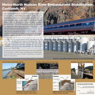
GeoDesign Metro-North Hudson River Embankment Stabilization_ACECNY Platinum
•
0 likes
•
98 views
T
Theresa Casey, FSMPS, CPSM
Follow
Report
Share
Report
Share
1 of 1
Download now
Download to read offline
Recommended
GeoDesign
GeoDesign
Serge Bachinsky
GeoDesign Report
GeoDesign Report
Serge Bachinsky
Slidashare herrera
Slidashare herrera
emysara
Digital Delta presentation connection the water data sharing concept in the Netherlandse with developments in geo data infrastructure, Inspire and geo design.
Digital delta & geodesign sept2014: connection water data with geo data infra...
Digital delta & geodesign sept2014: connection water data with geo data infra...
Raymond Feron
[This keynote lecture was part of the Digital Landscape Architecture conference, delivered 5 June 2015, at the Bauhaus, Dessau, Germany.] Humans have never been more capable of identifying their individualized location upon the surface of the Earth. A dazzling mesh of wired and wireless infrastructure permeates the planet and reaches far into the atmosphere. These materials are most recent manifestations within a long continuum of retentional techniques for the reproduction of humanity itself. The map stretches the lengths of this continuum, albeit with differing rhythms and volumes of use. Beyond identifying with the land, humanity inscribes upon the land with the broadest and most minute forces and movements -- all resolved through the machinic assembly of our location-aware society. The map is therefore both a guide for and record of these processes of inscription. However, if the map is not simply understood as a window onto spatial phenomena, as over a century of radical engagements with and upon the map have made evident, then what might be the benefit of treating the map instead as an agar, that material of microbiological inquiry -- a substance upon and within which cultures and acculturation is produced? Perhaps the map is more an artifact of the times and spaces of map-use than a clarified vision of reality. Thought in this way, the map becomes an externalization of human culture, memory, and action, and we can register the reverberations of the power geometries that produced such maps and allowed them to persist.
Location-aware futures and the map
Location-aware futures and the map
Matthew Wilson
3D Urban Design simulation
Urban Design Simulation with utilizing CityEngine and SiteOps
Urban Design Simulation with utilizing CityEngine and SiteOps
Tatianna Swenda, LEED Green Associate
Presentation on GeoDesign given at the International Symposium on Digital Earth / WALIS Forum 25th August 2011- Perth
GeoDesign for Sustainable Development
GeoDesign for Sustainable Development
Tom Gardner
GIS is a system of record and as such incredably valuable basis for design. In the Geodesign process, (3D) GIS technology is incredably powerful for visualizing and analyzing urban designs. Procedural modellng in CityEngine allows city planners and designers generate flexible designs that allow for manipulation of all design parameters. 3D GIS technology connects the real world as it is stored in a realistic model with the virtual worlds of the future designed with procedural modelling.
How 3D GIS connects the real world with virtual worlds
How 3D GIS connects the real world with virtual worlds
Niels van der Vaart
Story_2_Mid_Coast_Trolley_Extension
Story_2_Mid_Coast_Trolley_Extension
Theresa Casey, FSMPS, CPSM
Story_2_Kosciuszko_Bridge
Story_2_Kosciuszko_Bridge
Theresa Casey, FSMPS, CPSM
Story_1_Apple_Campus_2
Story_1_Apple_Campus_2
Theresa Casey, FSMPS, CPSM
2016-January Marketer_Announcing Markendium BOK article
2016-January Marketer_Announcing Markendium BOK article
Theresa Casey, FSMPS, CPSM
360 Facility Life Cycle-Weitz_Print
360 Facility Life Cycle-Weitz_Print
Theresa Casey, FSMPS, CPSM
SnyderCPA_BusCard_front-back
SnyderCPA_BusCard_front-back
Theresa Casey, FSMPS, CPSM
More Related Content
More from Theresa Casey, FSMPS, CPSM
Story_2_Mid_Coast_Trolley_Extension
Story_2_Mid_Coast_Trolley_Extension
Theresa Casey, FSMPS, CPSM
Story_2_Kosciuszko_Bridge
Story_2_Kosciuszko_Bridge
Theresa Casey, FSMPS, CPSM
Story_1_Apple_Campus_2
Story_1_Apple_Campus_2
Theresa Casey, FSMPS, CPSM
2016-January Marketer_Announcing Markendium BOK article
2016-January Marketer_Announcing Markendium BOK article
Theresa Casey, FSMPS, CPSM
360 Facility Life Cycle-Weitz_Print
360 Facility Life Cycle-Weitz_Print
Theresa Casey, FSMPS, CPSM
SnyderCPA_BusCard_front-back
SnyderCPA_BusCard_front-back
Theresa Casey, FSMPS, CPSM
More from Theresa Casey, FSMPS, CPSM
(6)
Story_2_Mid_Coast_Trolley_Extension
Story_2_Mid_Coast_Trolley_Extension
Story_2_Kosciuszko_Bridge
Story_2_Kosciuszko_Bridge
Story_1_Apple_Campus_2
Story_1_Apple_Campus_2
2016-January Marketer_Announcing Markendium BOK article
2016-January Marketer_Announcing Markendium BOK article
360 Facility Life Cycle-Weitz_Print
360 Facility Life Cycle-Weitz_Print
SnyderCPA_BusCard_front-back
SnyderCPA_BusCard_front-back
Download now