A Walk through Devon - Day 5 - Bondleigh Bridge to Morchard Bishop
•Download as PPTX, PDF•
0 likes•41 views

Day 5 of an 8-day walk through Devon. An 8-mile walk from Bondleigh Bridge to Morchard Bishop on a route that could be used by Lands End to John O'Groats long distance walkers passing through the county

Recommended
Recommended
More Related Content
What's hot
What's hot (17)
Similar to A Walk through Devon - Day 5 - Bondleigh Bridge to Morchard Bishop
Similar to A Walk through Devon - Day 5 - Bondleigh Bridge to Morchard Bishop (20)
More from John Downs
More from John Downs (18)
Recently uploaded
Recently uploaded (16)
A Walk through Devon - Day 5 - Bondleigh Bridge to Morchard Bishop
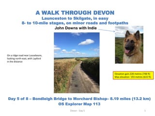
- 1. A WALK THROUGH DEVON Launceston to Skilgate, in easy 8- to 10-mile stages, on minor roads and footpaths John Downs with Indie Day 5 of 8 – Bondleigh Bridge to Morchard Bishop– 8.19 miles (13.2 km) OS Explorer Map 113 Devon - Day 5 1 Elevation gain 228 metres (748 ft) Max elevation 193 metres (633 ft) On a ridge road near Loosebeare, looking north-east, with Lapford in the distance
- 2. Day 5 - Bondleigh Bridge to Morchard Bishop My pre-walk Plan Devon - Day 5 2 Distance (miles) Directions (OS 113 ) Bondleigh to Morchard Bishop 8 miles 2 Take road east out of Bondleigh on minor road, bearing left at Lowton to Titterton’s Cross, Farley’s Grave and Newton Cross 2 Take left at Newton Cross on minor road to Blackditch Cross 4 Straight across at Blackditch Cross to Kiellands Cross and then right to Bury Cross. Cross River Yeo and then on eastwards to Rudge, Upcott and Morchard Bishop. Join Two Moors Way - END
- 3. Day 5 - Bondleigh Bridge to Morchard Bishop OS map detail for Bondleigh Bridge to East Leigh area Devon - Day 5 3
- 4. Day 5 - Bondleigh Bridge to Morchard Bishop OS map detail for East Leigh area to Morchard Bishop Devon - Day 5 4
- 5. Day 5 - Bondleigh Bridge to Morchard Bishop A fine country walk, all on quiet minor roads, memorable for wonderful views of rural Devon on both sides of the roads for much of the route. Also memorable for not passing through/by any villages, hamlets, shops or pubs – so all/any walking supplies need to be carried from start. An initial climb up to high ground at Farley’s Grave and then two descents into valleys to cross first the B3220 and then the River Yeo and the A377. A final 2.4 mile walk on a minor road up from the A377 to Morchard Bishop situated on a hill. Devon - Day 5 5
- 6. Day 5 - Bondleigh Bridge to Morchard Bishop - Overview of route A quiet scenic walk, mostly along barely-used ridge roads, with fine views either side. Starting with a walk uphill from Bondleigh Bridge to Farley’s Grave crossroads at 192 metres, and then some level ridge walking before dipping down to Newtons Cross. Another short ascent to Southdown, passing Loosebeare, and then down again to Blackditch Cross (B3220). Another climb to Edgerley Cross and Kelland Cross follows before descending to Bury Cross (A377). A final walk uphill to Morchard Bishop at 167 metres altitude. General Directions : 1st leg – 2.8 miles Head east on a minor road to Leigh Cross 2nd leg – 2.8 miles Continue on minor road to Blackditch Cross and on to Bury Cross (A377). 3rd leg -2.4 miles Pass Bugford Mill on minor road after A377 and proceed east to Morchard Bishop. Devon - Day 5 6
- 7. Set off from Bondleigh Bridge at 11.38 on a dry sunny day, 16oC. Starting altitude: 101metres. Headed east straight uphill on a minor road past Lowton (on the right), to Titterton Cross and up to Farley’s Grave @ 1.63 miles and 193 metres altitude – the high point of the day’s walk. Carried on straight ahead across Farley’s Grave crossroads (signposted Newton 1) to Newton Cross @ 2.28 miles, elapsed time 1 hour 9 minutes, altitude 176 metres. Large open fields, with many horses either side on this section (Elite Stallions UK establishment nearby). Followed the road left at Newton Cross (signed Lapford and Morchard Rd) and continued, descending gradually, to Leigh Cross with cluster of white cottages @ 2.82 miles, elapsed time 1 hour 23 minutes, altitude 159 metres. Great open views of this part of Devon in all directions. Highly recommended walk. Day 5 - Bondleigh Bridge to Morchard Bishop - First leg to Leigh Cross – 2.8 miles Devon - Day 5 7
- 8. Day 5 - Bondleigh Bridge to Morchard Bishop - First leg to Leigh Cross – 2.8 miles Clockwise from left: Field on left near top of hill coming up from Bondleigh Bridge ; looking back downhill towards Bondleigh from near to Titterton Cross; View on the left just before Titterton Cross Devon - Day 5 8
- 9. Day 5 - Bondleigh Bridge to Morchard Bishop - First leg to Leigh Cross – 2.8 miles Left to right: View left (northwards) from Tittertons Cross; the signpost at Farley’s Grave Devon - Day 5 9
- 10. First a wonderful ridge walk from Leigh Cross on a minor road for 1.4 miles with fantastic views to the left and ahead before descending to Blackditch Cross @ 4.23 miles, altitude 114 metres and elapsed time 2 hour 7 minutes. Cross the B3220 and climb minor road (signed Lapford) up to high point of 155 meters near Pennycotts (4.73 miles) and then down to Edgerley Cross and Kelland Cross. Take a right at Kelland Cross down to Bury Barton (note old barn by roadside) and then Bury Cross and the A377. Altitude here: 82 metres. Distance travelled since start: 5.83 miles in 2 hours 54 minutes. Day 5 - Bondleigh Bridge to Morchard Bishop - Second leg from Leigh Cross to Bury Cross– 2.8 miles Devon - Day 5 10
- 11. Day 5 - Bondleigh Bridge to Morchard Bishop - Second leg from Leigh Cross to Bury Cross– 2.8 miles Looking to the left (north) from around Newton Cross and Man’s Newton Devon - Day 5 11
- 12. Day 5 - Bondleigh Bridge to Morchard Bishop - Second leg from Leigh Cross to Bury Cross– 2.8 miles The ridge road running east towards Lapford after Leigh Cross (left) and the view left (northwards) from the road Devon - Day 5 12
- 13. Day 5 - Bondleigh Bridge to Morchard Bishop - Second leg from Leigh Cross to Bury Cross– 2.8 miles Left to right : On the ridge road near Loosebeare descending towards Blackditch Cross; a view north (left) a few minutes later; Blackditch Cross , the B3220 and the road to Bury Cross (signed Lapford) on the other side. Devon - Day 5 13
- 14. Day 5 - Bondleigh Bridge to Morchard Bishop - Second leg from Leigh Cross to Bury Cross– 2.8 miles Left to right : Old barn by roadside at Bury Barton; aerial view of Bury Barton farm ( site of a Roman fort), Bury Cross and the A377, and the start of the minor road up to Morchard Bishop Link to Roman Fort details: https://ancientmonuments.uk/100941-a-roman-fort-and-roman-camp-at-bury-barton- lapford#.YB788-j7SUk Devon - Day 5 14
- 15. Turn right onto the A377 and then take the minor road on the left over the River Yeo - climbing up past Bugford Mill, then on to Rudge and over Colt’s Hill. Continue on past Upcott and Turning Ways, climbing up the main street of Morchard Bishop to the pub at the top of the hill. Total elapsed walking time was 3 hours 59 minutes, and distance travelled from Bondleigh Bridge was 8.19 miles. Altitude at destination in Morchard Bishop: 167 metres. Morchard Bishop has the longest row of terraced thatched cottages in England, and many buildings that were built in the l4th and 15th centuries. Day 5 – Bondleigh Bridge to Morchard Bishop– Third leg from Bury Cross to Morchard Bishop – 2.5 miles Devon - Day 5 15
- 16. Day 5 – Bondleigh Bridge to Morchard Bishop– Third leg from Bury Cross to Morchard Bishop – 2.5 miles Left to right: After Bury Cross, looking back to the bridge of the River Yeo; views ahead on the road up to Morchard Bishop Devon - Day 5 16
- 17. Day 5 – Bondleigh Bridge to Morchard Bishop– Third leg from Bury Cross to Morchard Bishop – 2.5 miles Scenes walking up through Morchard Bishop. Destination for the day’s walk was the 16th Century “The London Inn” pub at the top of hill Devon - Day 5 17
- 18. Day 5 – Bondleigh Bridge to Morchard Bishop Walk statistics (Garmin) Devon - Day 5 18