2. 2380 J. C. Home et al
teristics commonly are associated with this name; CRITERIA FOR RECOGNITION OF
and (3) coal beds (and adjoining rocks) common- DEPOSITIONAL ENVIRONMENTS
ly are folded into broad anticlines and synclines
and, in places, are displaced by faults. The principal criteria for the delineation of de-
Basically, the thickest, most persistent, and best positional environments are readily illustrated in
quality coal seams were found to follow these the coal-bearing parts of the Carboniferous of
concepts reasonably well. However, thickening, eastern Kentucky and southern West Virginia
thinning, pinchouts, and changes in coal quality (Table 1). The identification of these various pa-
did occur, but these occurrences appeared to be leoenvironments in the Carboniferous strati-
random. In addition, when unexpected problems graphic section is based on the recognition of var-
were encountered, ingenious and often expensive ious counterparts m modern fluvial, deltaic, and
engineering techniques provided solutions to barrier systems. Figure 1 shows all the compo-
most of them. nents of these depositional systems but is not
Today, in many areas, the easily mined, high- meant to imply thai they are actually contempo-
quality coals are nearing exhaustion, and the in- raneous. This figure is based mainly on studies of
creased demand for clean, nonpolluting, safe en- modern environments of deposition, but includes
ergy brings a need for new approaches to explora- data from mine maps where coal has been
tion and mining that will make development of worked out, as well as from maps developed from
formerly unminable seams a profitable venture. borehole and outcrop information. The lower
Hence, the coal explorationist now must consider part of the figure shows a cross section through
such matters as roof and floor control, methane these environments with particular emphasis giv-
problems, and sulfur and trace-element distribu- en to the thickness and extent of peat (coal) units.
tions as well as problems of continuity and thick- This cross section was derived mostly from strip-
ness of coal seams. Because most practical appli- mine highwalls, large highway cuts, and closely
cations occur in relatively small areas of spaced borehole cross sections, as well as from
approximately 15,000 acres (6,100 ha.) or less, all borehole cross sections from modern coastal ar-
of the preceding factors require a high level of eas.
precision. On the left of Figure 1 is the barrier environ-
Investigations in the Appalachian region by the ment. In the Appalachian Carboniferous, barrier
Carolina Coal Group of the University of South environments (Fig. 2) are not important in terms
Carolina have shown that one of the most critical of minable coals and are not discussed in detail in
determinants of seam character at this level of this paper. However, this environment is impor-
investigation is the depositional environment of tant because barrier sands seal off the oxidizing
the coal and enclosing strata. These studies indi- effects of seawater and promote peat formation
cate that the topographic surface on which the landward.
coal swamp developed was a major factor in con- The principal criteria for recognizing barrier
trolling its thickness and extent, whereas the envi- environments are the lateral and vertical relations
ronments of deposition of the sediments that cov- of sedimentary structures and textural sequences
ered the peat strongly influenced both roof as well as the mineralogy of the sandstones. In a
conditions in mines and many aspects of coal seaward direction, the sandstones become finer
quaUty. grained and intercalate with red and green calcar-
Contemporaneous tectonic influences are su- eous shales and carbonate rocks with marine fau-
perposed on changes in seam character attributed nas whereas, landward, they grade into dark-gray
to variations in environments of deposition. lagoonal shales with brackish-water faunas. Be-
Rapid subsidence during sedimentation results cause of wave and udal reworking, sandstones of
generally in abrupt variations in coal-seam geom- the barrier system are more quartzose and better
etry and petrography but may favor lower sulfur sorted than those of the surrounding environ-
and trace-element contents, whereas slower subsi- ments even though both types had the same
dence rates favor greater lateral continuity but source area.
higher contents of sulfur and other chemically Landward, the barrier environments grade into
precipitated material. the lagoonal back-barrier environments (Fig. 3).
Thus, the principal objectives of this paper are The characteristics of this setting have been de-
to show the manner in which the depositional en- scribed by Home et al (1974). The principal com-
vironment influences the thickness, extent, qual- ponents of this environment are sequences of or-
ity, and potential minability of coal seams, and ganic-rich dark-gray shales and siltstones which
also, how the tectonic setting modifies these vari- are directly overlain by thin laterally discontinu-
ations. ous coals or burrowed sideritic zones. These la-
3. Deposltional Models In Coal Exploration 2381
Table 1. Criteria for Recognition of Depositional Environments*
Recognition F l u v i a l and Transitional Lower Delta Back-Barrier Barrier
Characteristics Upper Delta Lower Delta Plain
Plain Plain
I. Coarsening Upward
A. Shale and S l l t s t o n e 2-3 2 1 2-1 3-2
sequences
1. Greater than 50 f e e t 4 3-4 2-1 2-1 3-2
2. 5 t o 25 f e e t 2-3 2-1 2-1 2-1 3-2
B. Sandstone sequences 3-4 3-2 2-1 2 2-1
1. Greater than 50 f e e t 4 4 2-1 3 2-1
2. 5 t o 25 f e e t 3 3-2 2-1 2 2
II. Channel Deposits
A. Fine-grained abandoned 3 2-3 1-2 2 3-2
fill
1. Clay and s i l t 3 2-3 1-2 2 3-2
2. Organic debris 3 2-3 1-2 2-3 3
B. Active sandstone fill 1 2 2-3 2-3 2
1. Fine-grained 2 2 2-3 2-3 2
2. Medium- and coarse- 1 2-3 3 3 2-3
grained
3. Pebble lags 1 1 2 2-3 3-2
4. Coal spars 1 1 2 2-3 3-2
III. Contacts
A. Abrupt (scour) 1 1 2 2 2-1
B. Gradational 2-3 2 2-1 2 2
IV. Bedding
A. Cross-beds 1 1 1 1-2 1-2
1. Ripples 2 2-1 1 i 1
2. Ripple d r i f t 2-1 2 2-3 3-2 3-2
3. Trough cross-beds 1 1-2 2-1 2 2-1
4. Graded beds 3 3 2-1 3-2 3-2
5. Point-bar accretion 1 2 3-4 3-4 3-4
6. I r r e g u l a r bedding 1 2 3-2 3-2 3-2
V. Levee Deposits
A. Irregularly interbedded 1 1-2 3-2
sandstones and shales,
rooted
Mineralogy of Sandstones
A. Lithic graywacke 1 1 1-2 3 3
B. Orthoquartzites 4 4 4-3 1-2 1
VII. Fossils
A. Marine 4 3-2 2-1 1-2 1-2
B. Brackish 3 2 2 2-3 2-3
C. Fresh 2-3 3-2 3-4 4 4
D. Burrow 3 2 1 1 1
*Explanation: 1. Abundant 2. Common 3. Rare 4. Not Present
4. 2382 J. C. Home et al
AREA INFLUENCED BY AREA INFLUENCED
.MARINE TO BRACKISH WATER. BY FRESH WATER-
UPPER
BAR-1 BACK- I LOWER ITRANSITIONALi DELTA PLAIN-
RIER I BARRIER I DELTA PLAIN I LOWER I FLUVIAL,
DELTA
ORTHOQUARTZITE
SANDSTONE
GRAYWACKE COAL
SANDSTONE
0 10
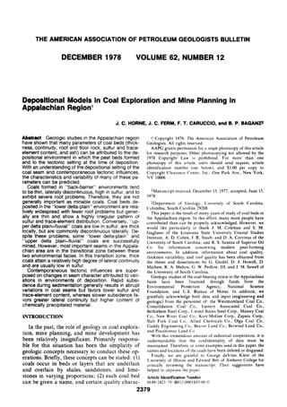
KILOMETERS MILES
FIG. 1—Depositional model for peat-forming (coal) environments in coastal regions. Upper part of figure is plan
view showing sites of peat formation in modern environments; lower part is cross section (AA) showing, in relative
terms, thickness and extent of coal beds and their relations to sandstones and shales in different environments
(modified from Perm, 1976).
goonal to bay-fill sequences (Fig. 4) become coar- tally in a landward direction for up to 3 mi (5 km;
ser upward, are extensively burrowed, and com- Fig. 3). Near the main body of orthoquartzite,
monly contain marine to brackish faunas. Sea- they are up to 20 ft (6 m) thick but thin abruptly
ward, they intertongue with orthoquartzitic and continue as nearly horizontal thin sheets 2 to
sandstones of barrier origin; in a landward direc- 3 ft (1 m) thick. In the thicker parts of the deposit,
tion, they intercalate with subgraywacke sand- bedding consists predominantly of planar to fes-
stone of fluvial-deltaic origin. The lagoonal de- toon cross-beds with amplitudes of 18 to 24 in.
posits are 25 to 80 ft (7.5 to 24 m) thick and 3 to (45 to 60 cm) and landward dip directions. Simi-
15 mi (5 to 25 km) wide. lar features have been observed in flood-tidal del-
The orthoquartzitic sandstones which inter- tas in modern lagoons (Hubbard and Barwis,
tongue with the dark-gray lagoonal bay fill are of 1976).
three general types. The first type consists of ex- The third type of orthoquartzite intertonguing
tensive sheets of plane-bedded orthoquartzites with the dark lagoonal shales is tidal-channel de-
with rippled and burrowed upper surfaces. These posits that may scour up to 40 ft (12 m) into un-
beds dip gently (2 to 12°) in a landward direction derlying strata (Fig. 3B). These deposits common-
(Fig. 3A). Similar features are present in modern ly are associated with the inclined sheet sands or
barrier washovers into open-water lagoons the wedge-shaped bodies; in addition they occur
(Schwartz, 1975). The second type consists of as isolated units. Associated levee deposits are ab-
wedge-shaped bodies that extend nearly horizon- sent or inconspicuous. Near the main sandstone
5. Depositional Models in Coal Exploration 2383
EXPLANATION
P T v i J ^ l SANDSTONE
I~Z^ SILTSTONE F> * ! * i W I > H GRAVEL [:-:-:-:-:j SHALE U^"^ *
:,,^ BlPPttO OK FLASEH- PENECONTEMPOSANEOUS
SANDSTONE COAL
1 BEOOEO SILTSTONE DEFORMATION STRUCTURES
SANDSTONE, RIPPLED ^ 7 7 ROOTED ZONE J^ MARINE FOSSILS
FIG. 2—Barrier model. Depositional composite of exposures near Monteagle, Tennessee, showing shoreface, bar-
rier, and back-barrier environments (Ferm et al, 1972).
bodies, the orthoquartzites contain herringbone, ganisms reworked the subaqueous subsurface,
festoon cross-bedding; grain size decreases up- and burrowed, sideritic cemented sandstones
ward in the unit. However, not all channels are were formed.
filled with sandstone; many are filled with dark- This general coarsening-upward pattern of in-
gray shales, siltstones, coal, or slump blocks. terdistributary bays is broken in many places by
Carboniferous lower delta-plain deposits of tongues of coarse-grained detritus introduced by
eastern Kentucky have been described by Baganz crevasse splays (Fig. 5B). Chemically precipitated
et al (1975). These deposits are dominated by iron carbonate is common in persistent bands or
thick coarsening-upward sequences of shale and as large concretions (up to 3 ft or 1 m in diame-
siltstone (Fig. 5A) which range in thickness from ter) along bedding surfaces. Undoubtedly, these
50 to 180 ft (15 to 55 m) and in lateral extent from secondary siderite concretions formed and Hthi-
5 to 70 mi (8 to 110 km). Recent counterparts of fied early as evidenced by the compaction of en-
these sequences are forming in interdistributary closing shales and siltstones around them.
bays and prodeltas of modern lower delta plains Commonly, the bay-fill sequences contain ma-
(Coleman et al, 1969). rine and/or brackish water fossils and burrow
In the lower part of these bay-fill sequences, structures. These fossils usually are most abun-
dark-gray to black clay shales are the dominant dant in the basal clay shales but also may be pres-
lithologies; some irregularly distributed lime- ent throughout the sequence.
stones and siderites are present also. In the upper Overlying and laterally equivalent to the bay-
part of these sequences, sandstones with ripples fill sequences are lithic graywacke sandstone bod-
and other current-related structures are common, ies 1 to 3 mi (1.5 to 5 km) wide and 50 to 90 ft (15
reflecting the increasing energy of the shallower to 25 m) thick. Recent counterparts of these de-
water as the bay fills with sediment. Where the posits are forming at the mouths of distributaries
bays filled sufficiently to form a surface upon in modern lower delta plains (Saxena and Ferm,
which plants could take root, coals formed. How- 1976). These distributary-mouth bar sandstones
ever, where the bays did not fill completely, or- (Fig. 6) are widest at the base and have gradation-
6. 2384 J. C. Home et al
lOOi
SCALES
ORTHOQUARTZITE TTT ROOTING
SANDSTOME
->./- BURROW STRUCTURE
DARK-GRAY SHALE
• AND SILTSTONE Mjr- CROSS - BEDS
RED A N D GREEN ^— RIPPLES ISO
SHALE FEET
WAVE TRAINS MARSH
BARRIER
ISLAND
EBB-TIDAL
DELTA
FLOOD-TIDAL
DELTA SANDSTONE
OFFSHORE] LAGOONAL
TIDAL CHANNEL
SHALE SANDSTONE SHALE
SHORE FACE
SANDSTONE FESTOON CROSS-BEDS
ORTHOQUARTZITE
PLANAR CROSS-BEDS
GRAY SHALE
RIPPLES
ggjj RED A N D GREEN SHALE
METERS
g ^ LIMESTONE
— COAL
TTTT ROOTING KILOMETERS
-^^ BURROW STRUCTURE
FIG. 3—A, Back-barrier deposits including storm washovers, tidal channels, and flood-tidal delta exposed in clay
pit along Interstate 64 west of Olive Hill, Kentucky. Side panels based on greater than 95% exposure (Home and
Ferm, 1976). B, Barrier and back-barrier environments including tidal channels and flood-tidal deltas exposed in
Carter Caves State Park region near Olive Hill, Kentucky (Home and Ferm, 1976).
7. Depositional Models in Coal Exploration 2385
COAL SEAT ROCK. CLAYEY
WAMP
BANDONED
SILTSTONE WITH QUARTZOSE SANDTONE FLASERS TIDAL CHANNEL
^ ^ n ^ ^ l D A L FLAT
CLAY SHALE WITH SIDERITE BANDS,BURROWED, FOSSILIFEROUS
— LAGOON
COAL SEATROCK.CLAYEY
SANDSTONE,QUARTZOSE PLANAR ACCRETION BEDS STORM
WASHOVERS
SHALE AND SILTSTONE.COARSENING UPWARD, BURROWED
^LAGOON
CLAY SHALE, SIDERITE BANDS, LIMESTONE, BURROWED,
FOSSILIFEROUS
COAL SEAT ROCK,CLAYEY SWAMP
SANDSTONE, QUARTZOSE, FINING UPWARD,
RIPPLED AND CROSS-BEDDED TIDAL CHANNEL
SILTSTONE WITH SANDSTONE FLASERS TIDAL FLAT
BURROWED SIDERITIC SANDSTONE
SANDSTONE QUARTZOSE, CROSS-BEDDED FLOOD-TIDAL
- DELTA
SHALE AND SILTSTONE,COARSENING UPWARD, BURROWED
LAGOON
CLAY SHALE, SIDERITE BANDS, BURROWED, FOSSILIFERO
FIG. 4—Generalized vertical sequence through back-barrier deposits in Carboniferous of eastern Ken-
tucky and southern West Virginia.
al lower and lateral contacts. Grain size increases 1,000 ft (300 m) wide and grade upward from
upward in the sequence and toward the center of coarse to fine with trough cross-beds in the lower
the bar. Laterally persistent fining-upward graded part and ripple drift in the upper. The basal con-
beds are common on the flanks of the bars as are tact, which is scoured along an undulating or
oscillation and current-rippled surfaces, whereas wavy surface, in many places truncates the under-
multidirectional festoon cross-beds are prevalent lying distributary-mouth bar and bay deposits.
in the central part of the bar. In the central area, Commonly, pebble-lag conglomerates are present
there is little lateral continuity of beds owing to at the base of the channel deposits as are coal
multiple scouring by flood currents. Slumps and "spars" which represent compressed pieces of
flow rolls are associated with the flanks and front wood or bark.
of the mouth bar where the sediment interface Because of the rapid abandonment of distribu-
steepened beyond the angle of repose. Fossils and taries, fine-grained clay plugs are the predomi-
burrow structures are generally absent within the nant type of channel fill in the Carboniferous
bar deposits but, where subaerial levees are con- lower delta-plain deposits of eastern Kentucky.
structed protecting the interdistributary areas These abandoned fills (Fig. 7) are comprised of
from the rapid influx of detrital sediments, organ- clay shales, siltstones, and organic debris which
isms returned and burrowed the flanks of the bar. settled from suspension in the ponded water of
Distributary channels in the lower delta plain the abandoned distributary. In some places, thick
are characterized by two types of sedimentary organic accumulations (now coal) filled these
fill: active and abandoned. Because channels in holes. The clay shales commonly are root pene-
the lower delta plain are straight with little ten- trated or burrowed. The only coarse-grained sedi-
dency to migrate laterally, active channel-fill de- ments present in the abandoned channels are
posits containing point-bar accretion beds are not thin-rippled and small-scale cross-bedded sands
common. Where present, these deposits consist of and silts which probably were deposited during
sandy sequences up to 60 ft (18 m) thick and floods or at sites near the distributary cutoff.
8. 2386 J. C. Home et al
Coal
Seat rock, clayey
Sandstone, fn. to rned.-grained, multi- Distributary-
directional planar and festoon cross-beds Mouth Bar
Sandstone, fine-grained, rippled
Sandstone, fine-grained, graded beds
Sandstone, flow rolIs
Sandstone, fine-grained, flaser-bedded L Distal Bar
and siltstone
Silty Shale and Siltstone with calcareous Interdistributary
concretions thin-bedded, burrowed, Bay
occasional fossil Or
Prodelta
Clay Shale with siderite bands, burrowed,
fossiliferous
SAND 1 SILT CLAY
Coal
Rooted Sandstone Channel
Sandstone, f i n e - g r a i n e d , climbing r i p p l e s
Sandstone, f i n e to medium-grained
Sandstone, med.-grained, festoon cross-beds Distributary-
Congl. Lag, siderite pebble, coal spar Mouth Bar
Sandstone, Siltstone, graded beds
Sandstone, flow rolls
Distal Bar
Sandstone, S i l t s t o n e , flaser-bedded
S i l t s t o n e and S i l t y Shale thin-bedded, nterdistributary
burrowed
Burrowed s i d e r i t i c Sandstone
Sandstone, f i n e - g r a i n e d Crevasse Splay
Sandstone, f i n e - g r a i n e d , r i p p l e d
S i l t y Shale and S i l t s t o n e w i t h calcareous Interdistributary
c o n c r e t i o n s , t h i n - b e d d e d , burrowed Bay
Or
Clay Shale w i t h s i d e r i t e bands burrowed, Prodelta
f o s s i l iferous
FIG. 5—Generalized vertical sequences through lower delta-plain deposits in eastern Kentucky. A, Typical
coarsening-upward sequence. B, Same sequence interrupted by splay deposit (Baganz et al, 1975).
In the Carboniferous lower delta-plain deposits those associated with abandoned fills, are thin
of eastern Kentucky, levees are thin and poorly but relatively widespread parallel with distribu-
developed, the largest being about 5 ft (1.5 m) tary trends.
thick and 500 ft (150 m) wide. Levees consist of The final major component of the lower delta
poorly sorted, irregularly bedded, partially rooted plain is the crevasse splay (Fig. 8). These deposits
siltstones and sandstones. These beds display a contain all the characteristics of coarsening-up-
pronounced dip (about 10°) away from the asso- ward minideltas. They become gradationally finer
ciated channel (Fig. 7). Coal beds, other than grained away from the breached levee to where
9. Depositional Models in Coal Exploration 2387
DISTRIBUTARY CHANNEL
LEVEE
CREVASSE
SPLAY
MUDS
DISTRIBUTARY-MOUTH BAR SANDS
200
SANDSTONE
BEDDING
100 300
^SHALE AND RIPPLES
SI ITS TONE
CROSS-BEDS
f " T T ROOT STRUCTURES
FLOW ROLLS
T^ BURROW STRUCTURES
FIG. 6—Distributary-mouth bar sandstone exposed in interval below lower Elkhorn coals along U.S. Highway 23
north of Pikeville, Kentucky. Side panels of block diagram based on greater than 90% exposure (Baganz et al, 1975).
FIG. 7—Abandoned channel fill with thin levees near Ivel, Kentucky. Levee dips away
from channel.
10. 2388 J. C. Home et al
LEVEE
DISTRIBUTARY
CHANNEL
CREVASSE
123 SANDSTONE
SCALES
• SPtAY SItTSTONE AND SHALE
l^yj BAYFILL SHALE
• i COAL
5• IN FEET
FIG. 8—Crevasse-splay deposits exposed in interval above upper Elkhorn Nos. 1 and 2 coals along U.S. Highway
) 250 5C
23 near Betsy Layne, Kentucky. Side panels of block diagram based on greater than 80% exposure (Baganz et al,
1975).
they grade laterally into interdistributary bay-fill lower part. Bedding in these sandstone bodies is
sequences. Commonly, an abandoned channel fill massive, with thick festoon cross-beds in the low-
occurs in a splay which formed as a result of the er part; upward, these massive beds merge into
closing of the crevasse in the levee. Carboniferous point-bar accretion beds (average dip of 17°) con-
splays vary in size with thicknesses up to 40 ft (12 taining smaller scale festoon cross-beds. These
m) and horizontal extents ranging from 100 ft (30 beds are overlain by partially rooted sandstones
m) to 5 mi (8 km). and siltstones with climbing ripples. All of these
In contrast to the thick fine-grained bay-fill se- characteristics, in addition to the lateral relations,
quences of the lower delta-plain deposits, the suggest a high-energy channel flanked by
eastern Kentucky Carboniferous upper delta swamps, small ponds, and lakes (Fig. 11). The up-
plain-fluvial deposits are dominated by linear, ward-widening cross-sectional shape of the sand-
lenticular bodies of sandstone which, in cross sec- stone bodies and the point-bar accretion beds in-
tion (Fig. 9), are 50 to 80 ft (15 to 25 m) thick and dicate that meandering was important in the
1 to 7 mi (1.5 to 11 km) wide. These sandstone development of these deposits. These sandstone
bodies contain scoured bases, sharply truncating bodies show an en echelon arrangement suggest-
the surface upon which they lie, but laterally, in ing episodes of lateral jumping of channels into
the upper part, they intertongue with gray shales, adjoining backswamps.
siltstones, and coal beds (Fig. 10). The sandstone Backswamp deposits consist of sequences
mineralogy varies from lithic graywackes to ar- which, from base up, are comprised of seat earth,
koses; grain sizes are predominantly medium to coal, shale with abundant plant fossils and rare
coarse. Above the scoured base, grain size dimin- freshwater pelecypods, siltstone, sandstone, seat
ishes upward within these sandstones; abundant earth, and coal. The sandstone thickens laterally
pebble lags and coal "spars" are present in the and merges with the major sandstone bodies. The
11. NORTH SOUTH
1000 2000
D
(D
-rIO M
5"
3
m
500M
i5»
LEGEND I
Em SANDSTONE O
o
Lin SANDSTONE A N D SILTSTONE S.
m
£13 SHALE A N D SILTSTONE X
•o
^ SIDERITE SANDSTONE
o"
5'
^a BLACK SHALE 3
F^ PLANT SHALE
M~2 BONE SHALE
^m COAL
FIG. 9—Upper delta plain-fluvial deposits exposed along U.S. Highway 23 south of Louisa, Kentucky. Cross section is based on more than 60%
00
exposure along highway (Home and Baganz, 1974).
12. 2390 J. C. Horne et al
COAL W I T H CLAY SPLIT
SEAT ROCK, CLAYEY BACKSWAMP
SANDSTONE A N D SILTSTONE, LEVEE
CLIAABING RIPPLES,ROOTED
SANDSTONE,MEDIUM TO COARSE
GRAINED, FESTOON CROSS-BEDDED CHANNEL
FLOOD PLAIN
COAL WITH SEAT-ROCK SPLITS BACKSWAMP
SEAT ROCK, SILTY
SANDSTONE A N D SILTSTONE,
CLIMBING RIPPLES, ROOTED
LEVEE
SANDSTONE M E D I U M TO COARSE
GRAINED FESTOON CROSS-BEDDED
CHANNEL
CONGLOMERATE LAGSIDERITE PEBBLES
SLUMPS ^^rr LAKE
SILTSTONE, THIN-BEDDED
FLOOD PLAIN
COAL WITH CLAY SPLITS BACKSWAMP
FIG. 10—Generalized vertical sequence through upper delta plain-fluvial deposits of
eastern Kentucky and southern West Virginia.
SWAMP POINT BAR
LEVEE
SCALES
1.; i SANDSTONE 301 lOOn
5^ SILTSTONE AND SHALE
METERS FEET 50
o.c. PEBBLE LAG
—
^^''
-^^-
:/5
COAL
ROOTING
TROUGH CROSS-BEDS
BEDDING PLANES
L=_ L.
METERS
300 500
FEET
1000
FIG. 11—Reconstruction of upper delta plain-fluvial environments as exposed in interval around Haz-
ard No. 6 coal along Daniel Boone Parkway and Kentucky Route 15 northeast of Hazard, Kentucky.
Side panels of diagram based on greater than 65% exposure.
13. Depositional iModels in Coal Exploration 2391
thin (5 to 15 ft; 1.5 to 4.5 m), fine-grained, up- between depositional environments are those ef-
ward-coarsening sequences are typical deposits of fects that arise from broad-scale contemporane-
open-water bodies, probably shallow ponds or ous tectonic influences. This point is illustrated
lakes. The lateral extent of these deposits is only 1 by a generalized regional cross section of the Car-
to 5 mi (1.5 to 8 km). boniferous from Bluefield in southern West Vir-
Levee deposits consist of poorly sorted, irregu- ginia to Pittsburgh, Pennsylvania (Fig. 16). South
larly bedded sandstones and siltstones that are of the Paint Creek fault zone, the section thickens
extensively root penetrated. They are thickest (up greatly in response to an increased rate of subsi-
to 25 ft; 8 m) near active channels, and decrease dence (Ferm, 1976).
both in grain size and thickness away from the This large differential rate of subsidence from
channels. The levee deposits also display a promi- south to north produced very pronounced effects
nent dip (up to 10°) away from the channel. on depositional environments and, consequently,
Coals in the upper delta plain-fluvial deposits are on the characteristics of distribution and quality
locally thick (up to 32 ft; 10 m) but are laterally of the enclosed coal seams. In the southern area
discontinuous (sometimes pinching out within of more rapid subsidence, the depositional facies
500 ft; 150 m). are stacked on each other and exhibit slow rates
Between the lower and upper delta-plain de- of progradation, whereas in the more stable (less
posits of the eastern Kentucky Carboniferous is a rapid subsidence) platform area on the north the
transitional zone that exhibits characteristics of depositional facies prograde very abruptly over
both the lower and upper delta-plain sequences this shelf. The transition from upper delta-plain
(Figs. 12, 13). The fine-grained bay-fill sequences to barrier environments occurs in a distance of
are thinner (5 to 25 ft; 1.5 to 7.5 m) than those of approximately 10 to 15 mi (16 to 24 km) in the
the lower delta plain. However, unlike the thin south, whereas on the more stable platform on
bay-fill sequences of the upper delta plain, they the north the same environmental transition oc-
contain marine to brackish faunas and are exten- curs very gradually over a distance greater than
sively burrowed (Fig. 14). 60 mi (96 km). The net effect of this change is
Channel deposits (Fig. 15) exhibit features of that, generally, the minable coals of southern
lateral migration such as point-bar accretion beds West Virginia display a much more restricted
similar to the channels of the upper delta plain, lateral distribution than those of western Pennsyl-
but these transitional delta-plain channels are fin- vania.
er grained than those of the upper delta plain. An equally important consequence of differen-
These channel deposits are single-storied se- tial regional subsidence is the sulfur content of
quences having one direction of lateral migration, coals. Coals of southern West Virginia, like those
whereas upper delta-plain channel sandstones are of western Pennsylvania, show an increase in to-
multistoried units with many directions of lateral tal sulfur (and reactive pyrite) as they pass from
migration. The levees associated with these chan- upper delta-plain to back-barrier environments.
nels are thicker (5 to 15 ft; 1.5 to 4.5 m) and more However, in the south, the effect is muted by the
extensively root penetrated than those of the low- rapid rate of sedimentation; the coals from south-
er delta plain. Thin (5 to 15 ft; 1.5 to 4.5 m) splay em West Virginia are well known for their low
sandstones are common in these deposits but are sulfur content. In contrast, the coals of the Pitts-
less numerous than in the lower delta plain, yet burgh area, which were deposited on a stable
they are more abundant than those of the upper platform where the rates of sedimentation were
delta plain. lower and chemical activity was higher than in
Because many of the interdistributary bays southern West Virginia, generally have a higher
filled with sediment in the transitional zone be- sulfur content. The same effect may be expected
tween the lower and upper delta plains, a wide- with the minor trace elements.
spread platform developed upon which peat In addition to the regional influences of con-
(coal) swamps formed. The resultant coals are temporaneous tectonism on depositional facies,
thicker and more widespread than the coals of the detailed local sedimentary responses to move-
lower delta plain. Most of the economically im- ments of basement features can be identified. Al-
portant coal seams of the Appalachian region are though most of the basement faults in eastern
in this transitional zone between lower and upper Kentucky do not offset the deposits of the coal
delta-plain environments. measures, there is ample evidence of sedimentary
responses to these contemporaneously active
INTERACTION OF DEPOSITIONAL structures. Figure 17 is a regional cross section
ENVIRONMENT AND TECTONIC SETTING (constructed from over 400 highway roadcuts) of
Superposed on changes in lithologic character the coal measures exposed along U.S. Highway
which can be attributed to variations within and 23 between Pikeville, Kentucky, on the south and
15. Depositional Models in Coal Exploration 2393
COAL.SEAT ROCK CLAYEY
S A N D S T O N E . F I N E - G R A I N E D , RIPPLED
CREVASSE SPLAY
SHALE AND SILTSTONE, COARSENING UPWARD
SIDERITE BANDS, BURROWED INTERDISTRIBUTARY BAY
COAL SEAT ROCK SILTY
SANDSTONE A N D SILTSTONE,CLIMBING
LEVEE
RIPPLES, ROOTED
SANDSTONE FINE TO M E D I U M - G R A I N E D CHANNEL
FESTOON CROSS-BEDOED
CONGLOMERATE LAG,SIDERITE PEBBLES
COAL.SEAT ROCK
SHALE AND SILTSTONE, COARSENING UPWARD :^?^?7Z^tREVASSE SPLAY
BURROWED INTERDISTRIBUTARY BAY
COAL.SEAT ROCK CLAYEY
SANDSTONE F I N E G R A I N E D RIPPLED fREVASSE SPLAY
SHALE A N D SILTSTONE COARSENING UPWARD INTERDISTRIBUTARY BAY
SIDERITE BANDS. BURROWED
COAL WITH SEAT ROCK SPLITS
LEVEE
SANDSTONE AND SILTSTONE,
CLIMBING RIPPLES, ROOTED
CHANNEL
SANDSTONE, FINE TO MEDIUM-GRAINED
FESTOON CROSS-BEDDED
CLAY SHALE, BURROWED
COAL
FIG. 13—Generalized vertical sequence through transitional lower delta-plain deposits of eastern Ken-
tucky and southern West Virginia.
Louisa, Kentucky, on the north. Although this di- are of economic significance in coal exploration
agram has been generalized, many relations be- and mine planning.
tween the basement structures and lithologic vari-
ations can be observed. Terrigenous clastic Variations in Thiciiness and Extent
wedges thin or pinch out, and coal beds may thin The three-dimensional shape (thickness and
or merge over these flexures. In addition, the in- lateral extent) of coal bodies is affected directly
tensity of root penetration also may increase over by the depositional setting in which they accumu-
the structural highs indicating longer exposure lated. The depositional environments that pre-
and deeper soil development. cede, coexist with, or are postdepositional modify
Finally, the most obvious feature is the "stack- the shape of the coal bodies, as do the internal
ing" or localization of channeling along the processes active within the coal swamps. The sed-
flanks of these flexures, which is emphasized on imentary environments that immediately precede
Figure 18, a block diagram of the area near the the coal swamp shape the topography on which
Blaine-Woodward fault. This fault is also shown the swamp develops. This topography affects
at the north end of the regional cross section (Fig. most directly variations in coal thickness, al-
17) in the area 3 mi (5 km) south of Louisa, Ken- though to a lesser extent it also affects the lateral
tucky. Regional paleocurrent analyses indicate continuity of the seam. Those environments that
the channels shown on Figure 18 were carrying coexist laterally with the peat (coal) swamp, as
sediment from southeast to northwest. However, well as internal processes within the swamp such
just south of the Blaine-Woodward fault, the pa- as the plant growth, plant decay, fires, and water
leocurrent directions indicate the channels were flow, directly affect the lateral continuity of the
deflected to the west. Thus, the channels were lo- coal-forming deposits and, to a lesser extent,
calized on the downthrown (southern) side of the thickness variations of the seams. Following
fault. This area should be avoided from the stand- burial of peat (coal) beds, the processes of postde-
point of coal exploration because the coals have positional environments, such as channeling, may
been removed by the channeling. impinge downward and modify the upper surface
of the deposits. These processes cause local thin-
APPLICATION OF DEPOSITIONAL MODELS ning and the interruption of the lateral continuity
The deUneation of depositional environments of seams by channel "washouts" (the removal of
can be applied to produce predictive models that coal by channel scouring).
16. 2394 J. C. Home et al
CREVASSE SWAMP
SPLAY
LEVEE
POINT BAR
~~] SANDSTONE 100
I ] SANDSTONE AND SILTSTONE
3 0Ia F E 5ol
ET
FEET 50 SCALES
^ ^ SHALE
L
— COAL
r7Tf ROOTING METERS
0 1000 2000
~-^ BURROW STRUCTURE
FEET
^ MARINE FOSSIL
^5?? BEDDING PLANES
V>^ TROUGH CROSS-BEDS
FIG. 14—Reconstruction of transitional lower delta-plain environments as exposed along U.S. Highway 23 near
Sitka, Kentucky. Side panels based on greater than 70% exposure (Home and Perm, 1976).
On a regional scale, depositional models can be By contrast, in river-dominated lower delta-
used to predict the trends of coal bodies. These plain deposits of the Appalachian Carboniferous,
models are useful in an initial phase of coal explo- the coal bodies are elongate parallel with deposi-
ration. Moreover, locally, they permit a detailed tional dip. This trend exists because the only sites
understanding of variations in coal thickness and where peat swamps can develop are on the nar-
lateral continuity that can aid in mine planning row, poorly developed levees along the distribu-
and development. tary channels. These river-dominated lower delta-
Regionally, back-barrier coal bodies formed plain channels generally are straight and rapidly
landward of contemporaneous or preexisting bar- prograde seaward in the direction of depositional
rier systems. The coal swamps developed on plat- dip. For this reason, the coals that develop in this
forms that evolved as the result of infilling of the environment are continuous laterally in the direc-
lagoons behind the barriers. Coexisting and post- tion of depositional dip but discontinuous parallel
depositional tidal channels may modify the back- with depositional strike, being interrupted by in-
barrier coals into pod-shaped bodies. However, terdistributary bay-fill deposits. These seams
the trend of these pod-shaped seams parallels the commonly are relatively thin and contain numer-
trend of the associated barrier systems, and bar- ous splits caused by crevasse splays that breached
riers, most commonly, are elongate parallel with the poorly developed levees along the distributary
depositional strike. channels.
17. Depositional Models in Coal Exploration 2395
ms^Mi^^^
)CXZ3EX3dCSZ3dCCZZaSDDCZ3X3SE
^^'TrTTTTTTT-T-T-^rT-T-T—T-T—7—r-T—?—r-?—f t- ^ , -r f
» -t—7—-< • < <•'•!. f v '^ " "^^ >".<"<
• SANDSTONE o.o* PEBBLE LAG
lOOn 20n
• SANDSTONE
AND SIITSTONE
SHALE AND
SILTSTONE
——
jrr
COAL
ROOTING
BURROWED <2l^ SLUMP STRUCTURE 600
SIDERITE SANDSTONE
1000 2000
FIG. 15—Fine-grained point-bar, channel, and backswamp deposits exposed along Interstate 64, 4 mi west of Rush,
Kentucky (Home and Ferm, 1976).
Upper delta plain-fluvial coals also tend to coeval channels, and in some places, they contain
parallel depositional dip. However, they are not "washouts" where later periods of channeling
so laterally continuous in that direction as the have scoured through the coals. Although the
coals of the lower delta plain. These seams occur other depositional settings contain many econom-
in pod-shaped bodies that accumulated on flood ic coals, most of the important widespread coals
plains adjacent to coexisting meandering chan- of the Appalachian region have accumulated in
nels. As a result, coals formed in this setting dis- this transition zone between the lower and upper
play abrupt variations in thickness over short delta plains.
lateral distances with numerous splits occurring Thus, in an initial exploration phase, an under-
in the coals near the levees of the contemporane- standing of the controls depositional environ-
ously active channels. In addition, postdeposi- ments exert on the shape of coal bodies is impor-
tional channeling may interrupt further the lateral tant in designing a drilling program that can trace
continuity of these seams by causing "washouts." the trends of coal bodies. However, at the stage of
Within the transition zone between the lower mine planning and development, a detailed
and upper delta plains, many of the large interdis- knowledge of the influence of depositional envi-
tributary bays have filled with sediment providing ronments on variations in coal thickness is most
a broad platform upon which widespread coal critical.
swamps can develop. In this depositional setting, The Beckley coal of southern West Virginia il-
the resultant coal bodies are extensive laterally lustrates these characteristics. Figure 19 is a pa-
with an inclination to be slightly elongate parallel leogeographic reconstruction of the depositional
with depositional strike. Similar to the upper delta setting of the Beckley coal. This reconstruction is
plain-fluvial coals, these transitional lower delta- based on data from 1,000 core holes in a 400 sq
plain seams develop splits adjacent to levees of mi (1,000 sq km) area. Regionally, this coal accu-
18. POCAHONTAS BASIN DUNKARP BASIN 0>
AUfCHCNT
POTTS VIILI
MISSlSSIfPlAN
o
3
(D
<5.
BLUEFIELD
c * * r o w c i KM ot cicx
0 50
SCALES KILOMETERS
F I G . 16—Cross section of Pottsville a n d Allegheny Formations from vicinity of Bluefield, West Virginia, to Pittsburgh, Pennsylvania, showing general arrangement of
coal beds a n d depositional environments in which they formed (after Ferm a n d Cavaroc, 1969).
19. REGIONAL CROSS SECTION
ALONG U.S. 23
PIKEVILLE TO LOUISA, KENTUCKY
f
O
BtAINE
a
WAIBRIDGE
SYSTEM • f f T y v » ^ < t < t '>i.yT y >
LEGEND
'_ Q ORTHOOUARTZITE I
, SANnSIONE , ——^..^-y—-f'•-•: " J ^ * ^ m
- ^ r-^'-r-'-i''^'^'^,—-^ V ^ X
t 1 bHAlE ANO SIlISTONf ,» ?^ •o
'—•—J I ^' » ; ••• < • »' A • r f , > ^ . ) < ^ . ^ ^
f^^£^ BURROWED SIOEKIIE o"
PAINT CREEK Q>
~=H IIMESTCINE
IRVINE
^ 1 COAl SYSTEM
["^'^ ROOTS
0 KIIOMETERS 10
SCALES
FIG. 17—Regional cross section of lateral relations of coal beds and enclosing lithologies exposed along U.S. Highway 23 between Louisa, Kentucky, u
on north and Pikeville, Kentucky, on south. Cross section is constructed from over 400 highway roadcuts (Home et al, 1976a).
20. 2398 J. C. Home et al
LEGEND
CZ] SANDSTONE
SHALE AND SILTSTONE
COAL
TTf ROOTS 360 0 500 1000
< ^ DIRECTION OF PALEOCURRENTS
FIG. 18—Localization and deflection of channeling along Blaine-Walbridge fault south of Louisa, Kentucky.
Side panels based on greater than 60% exposure (Home et al, 1976a).
mulated landward (south) of a barrier system ting (Fig. 19). The coarsening-upward sequence
trending from east-northeast to west-southwest that was deposited over the preexisting coal (front
(Galloway, 1972; Robinson, 1975). The trend of panels. Fig. 20) formed as a result of the infilling
this back-barrier coal body parallels closely that of the lagoonal area landward of the associated
of the associated barrier system, although it is ab- barrier system. As the lagoonal area filled with
sent in places owing to concomitant and later sediment, tidal flats (flasered siltstone and sand-
tidal channels that produced "want areas" (areas stone) and salt marshes became established be-
of little or no coal). Thus, the Beckley coal be- tween intervening tidal channels (upper surface,
haves as other back-barrier coals with respect to Fig. 20A). This setting provided the topography
coal-body shape and regional trend, and present upon which the subsequent coal swamp formed.
and future exploration programs should be de- Initially a freshwater marsh and/or swamp de-
signed to take advantage of these characteristics. veloped on the high areas over the previous salt-
At the lease-tract level (15,000 acres; 6,000 ha., marsh surface and eventually spread over most of
or less), an understanding of coal-thickness varia- the area. As plant growth continued, the smaller
tions is important economically. To depict the in- channels and the upper parts of the larger chan-
fluence depositional environments exert in con- nels became clogged with organic material, and
trolling coal-thickness variations, the details of a only the major tidal channels continued to re-
mined-out area of the Beckley coal were used main open (Fig. 20B). Consequently, the thick-
(Fig. 20). ness variations in the resultant coal deposit reflect
Regionally, this mined-out area of the Beckley very closely the influence of the preexisting depo-
coal is situated in a back-barrier depositional set- sitional topography, with the thicker coal occur-
21. Depositional Models in Coal Exploration 2399
r ^ ORTHOQUARTZITIC SCALES
L 2 J SANDSTONE 0 5
1 1
FIASERED KILOMETERS
SILTSTONE
0 3.5
tfVKLl COAL < 2' '1 1
MILES
AREA
COAL>2' DETAILED
BLOCK DIAGRAM
FIG. 19—Regional depositional setting of Beckley coal and surrounding lithologies. Re-
construction is based on data from 1,000 core holes in 400 sq mi (1,000 sq km) area. Area
enclosed by heavy lines is detailed on Figure 26.
22. COAL
SWAMP
X' COAL
THICKNESS
5-lOft
SANDSTONE
F ~ n FLASER-BEDDED SILTSTONE
b ^ AND SANDSTONE
p S i l SHALE AND SILTSTONE
2000 0 600
FIG. 20—Block diagrams showing detailed relations of depositional topography and coal thickness. Front panels of
block diagrams are reconstructed from core-hole (average spacing, one record per 500 ft or 150 m) and mine data,
whereas plan views are reconstructed from mine maps. Depositional topography shown on surface of diagram A is
residual topography after regional dip has been removed by trend-surface program. On block diagram B, coal
thicknesses were contoured from thicknesses recorded on mine maps; within mine, elevations of base of coal and
thickness were recorded by engineers approximately every 75 ft (25 m). Regional setting of these detailed diagrams
of Beckley is shown on Figure 19.
ring in the former lows and the thinner coals over grained platy masses (cleats) occupying joints in
the highs. The coal is absent or badly split in the strata, and framboidal pyrite (Fig. 21; Caruc-
places where a few contemporaneous tidal chan- cio et al, 1977). The last is in clusters of spherical
nels remained active. agglomerates comprised of 0.25/1 grains of iron
As observed in this example, at the lease-tract disulfide and is disseminated finely throughout
level, coal-thickness variations are closely related the coal and associated strata. Of these four basic
to the preexisting depositional topography. This types, only the framboidal form decomposes
topography is the result of the depositional envi- rapidly enough to produce severe acid mine
ronments that existed prior to coal formation. In drainage in the absence of carbonate material
addition, the shape of the coal body is modified (Caruccio, 1970) and is so disseminated through
by coexisting and postdepositional environments the coal that it cannot be removed in the 1.50-
such as channels. If these factors are considered density sink fraction in washability tests.
during mine planning, the main tunnels of the Research by Love (1957). Love and Amstutz
mine could be designed to maximize economi- (1966), Cohen (1968), Rickard (1970), Berner
cally the recovery of the thicker bodies of coal (1971, Chap. 10), and Javor and Mountjoy (1976)
while avoiding the "want areas." suggests that the framboidal form of pyritic sulfur
is produced by sulfur-reducing microbial organ-
COAL QUALITY: SULFUR PROBLEMS isms which are found in marine to brackish wa-
Iron disulfides (FeSi) are present in coals either ters but not fresh water. Mansfield and Spack-
as marcasite or pyrite. They occur as euhedral man (1965), working with selected bituminous
grains, coarse-grained masses (greater than 25ft) coals from western Pennsylvania, have shown
which replace original plant material, coarse- petrographically that coals formed under the in-
23. Depositlonai Models in Coal Exploration 2401
SECONDARY REPLACEMENT
CLEAT COATS
EUHEDRA FRAMBOIDAL
PRIMARY
FIG. 21—Forms of pyrite that occur in coals.
fluence of marine water contained more sulfur along the South Carolina coast (Corvinus and
than those formed in fresh water. Similar sulfur Cohen, 1977), it has been documented that peats
variations were reported by Cohen (1968) and with high sulfur contents in the form of framboi-
Cohen et al (1971) in the modern peats of the dal pyrite are formed where the marshes are being
Everglades. transgressed by marine to brackish-water envi-
Among Carboniferous coal-bearing rocks in ronments. The only exception occurs where a suf-
western Pennsylvania, Williams and Keith (1963) ficient thickness of sediment is introduced early
demonstrated statistically that coals having roof enough to shield the peat from the marine to
rocks of marine or brackish-water origin contain brackish waters.
more sulfur than those with roof rocks of fresh- Thus, the environments of deposition of the
water origin. On the basis of research in the Car- sediments that overlie the coal are more impor-
boniferous of eastern Kentucky and southern tant to the distribution of the type and amount of
West Virginia, Ferm et al (1976) and Caruccio et sulfur in the coal than the environments of depo-
al (1977) have established that sulfur present in sition of the sediment on which the coal devel-
the framboidal form of iron disulfide is most oped. Consequently, coals that accumulated in
strongly associated with roof rocks deposited in areas under marine influence such as back-barrier
marine to brackish-water environments. Sim and lower delta-plain environments are likely to
larly, in the Everglades (Cohen et al, 1971) and be overlain by marine to brackish sediments and
24. 2402 J. C. Home et al
contain high amounts of disseminated pyritic sul- distribution of the amount of sulfur and the type
fur in the reactive framboidal form. of pyrite can permit the exploration for low-sulfur
Coals that amassed in the transitional lower coals in areas where the sulfur content is usually
delta-plain environment were farther from marine high. This strategy can be illustrated by an exam-
influences and, generally, contain less framboidal ple from the Carboniferous of the eastern United
pyritic sulfur. However, some of these coals are States. In this example, based on 450 core holes in
overlain by sediments that were deposited in shal- a 200 sq mi (500 sq km) area, the coal accumulat-
low-marine to brackish-water bays. That these ed in a lower delta plain environment. Where ov-
bays were open to marine influences is shown by erlain by marine to brackish roof rock, coals
the marine to brackish faunas preserved in the formed in this depositional setting commonly dis-
strata. Where this marine to brackish roof rock is play a propensity toward high (greater than 2%)
present, the pyritic sulfur in the underlying coal sulfur contents with most of the sulfur (greater
increases greatly, most of it being present as than 75%) in the form of framboidal pyrite (Ca-
framboidal pyrite. For this reason, the distribu- ruccio et al, 1977). However, when splay deposits
tion of disseminated pyritic sulfur is highly varia- are introduced early and are of sufficient thick-
ble in the transitional lower delta plain, although, ness, they shield the coal from the sulfur-reducing
overall, deposits in this environment are lower in bacteria, and the sulfur content remains low (less
pyritic sulfur than those in the more marginal ma- than 1%; Home et al, 1976b).
rine environments. An east-west cross section (Fig. 22) through the
Upper delta-plain to fluvial environments sel- exploration area shows a fossiliferous hmestone
dom are transgressed by marine to brackish wa- and black shale that he directly on coal X in the
ters, and almost all coals formed in these deposi- eastern part of the cross section. However, the
tional settings are low in pyritic sulfur. In limestone and black shale rise stratigraphically
addition, most of the iron disulfide present is of above the coal to the west, being separated by an
secondary origin in the forms of massive plant intervening wedge of terrigenous clastic sediment.
replacements and cleat fillings. The distribution and thickness of this detrital
At the lease-tract level, an understanding of the wedge, as well as the area where the limestone
controls that the depositional setting exerts on the and black shale directly overlie the coal, are
EAST-WEST GEOLOGIC CROSS SECTION
I00|
L L_
SANDSTONE pg5^ LIMESTONE
FEET 30|
SHALE AND B l COAL 50|
• SILTSTONE
BLACK SHALE ^TT ROOTING
000 0 3
FEET SCALES KILOMETERS
FIG. 22—Cross section showing distribution of lithologies overlying coal X. Location of cross section shown on
Figure 23.
25. Depositional Models in Coal Exploration 2403
shown in Figure 23. That the detrital sediment nous clastic sediment, the sulfur content decreas-
was introduced early and shielded the coal from es to less than 1%.
the marine to brackish waters is demonstrated by This example demonstrates the importance of
the fact that the deposits of these waters (the splay deposits in the formation of pockets of low-
limestone and black shale) overlie the terrigenous sulfur coal of sufficient areal extent to be eco-
clastic rocks. This configuration indicates that the nomic in the lower delta-plain setting, normally a
detrital influx occurred before or during marine high-sulfur coal realm. Because splay deposits
inundation. form adjacent to the distributary channels in this
Figure 24 is a reconstruction of the deposi- depositional setting, drilling programs should be
tional setting immediately after the formation of devised to define these features. In this manner,
coal X. It is based on data related to lithologic the areas of the lower delta plain with the greatest
and sediment-thickness variations. These data potential for low-sulfur coal can be delineated.
suggest that the levees of a distributary channel in The relations shown in this example illustrate
the southwestern part of the area were breached the closely parallel distributions of coals with dis-
several times forming large splay deposits in the seminated pyritic sulfur and roof rock of marine
north and east over the coal and into the inter- to brackish origin. Moreover, when terrigenous
vening interdistributary bay. In areas removed clastic sediment is introduced early and is of suf-
from this detrital influx, fossiUferous limestone ficient thickness, the sulfur content in the under-
and black shale were deposited from the marine lying coal remains low. With a knowledge of
to brackish waters of the bay. these characteristics and an understanding of the
Figure 25 illustrates the distribution of the sul- depositional setting, exploration programs can be
fur in coal X that cannot be removed in the 1.50- designed to outline areas of low-sulfur coal in
density sink fraction of washability tests. As ex- what is most commonly a high-sulfur coal prov-
pected, the coal in the eastern part of the area, ince.
where it is overlain by roof rock of marine to
brackish origin, is high in sulfur (greater than 2%) ROOF CONDITIONS
with most of the pyritic sulfur in the form of In the mines of southern West Virginia and
disseminated framboids. On the west and south eastern Kentucky, roof quality is dependent on
where the coal is overlain by the wedge of terrige- the interrelations of rock types, syndepositional
SCALES
1 T
miles
0 5
kilometers
pnqq LIMESTONE AND
^ 3 BLACK SHALE
^ ^ Otf-IOft
I I lOft-20Jt
[ ] greater than 20 ft
—^— line of cross section
FIG. 23—Thickness of terrigenous clastic wedge of sediment between coal X and overlying marine limestone and
black shale. Location of cross section in Figure 22 shown by heavy line.
26. 2404 J. C. Home et al
SCALES
0 5
kilomalars
DEPOSITIONAL
ENVIRONMENTS
OF ROOF ROCK
(
N
FIG. 24—Reconstruction of depositional setting immediately after formation of coal X. Diagram is based on data
related to lithologic and sediment-thickness variations.
SCALE
0 1 2 3
milM N
0 S
kilomatars
SULFUR PERCENT
1 1 iMslhanl
E '2
S 2 3
ma 4
[•*'] gr«al«r than 4
FIG. 25—Distribution of sulfur in coal X that cannot be removed in 1.50-density sink fraction of washability tests.
27. Depositional Models in Coal Exploration 2405
structures, early postdepositional compactional roof-support problems. However, separations at
traits, and later tectonic features (Ferm and Mel- sandstone-shale bedding planes can produce roof
ton, 1975). Because most of the deposits of the falls. Hence, roof bolting is an essential precau-
coal measures in this region are terrigenous clas- tion. Coarsening-upward rock sequences are
tic rocks, rock types are contingent upon grain characteristic of bay-fill deposits. Thick wide-
size and degree of cementation. Most commonly, spread bay-fill units dominate the lower delta-
the syndepositional features are burrow and root plain depositional setting, but they are also abun-
structures, bedding, and slickensided surfaces in dant in lagoonal bay fills of the back-barrier set-
clayey rooted zones. Where less compactible ting. To a lesser extent, they are present in the
rocks such as sandstone are surrounded by more thin bay fills of the transitional lower delta plain.
compactible types such as shales and siltstones, In some places, the coals are overlain by a brit-
differential compactional features occur. Super- tle, nonbedded, carbonaceous black claystone
posed on these characteristics are later tectonic that is jointed (called "cube rock" by miners).
structures such as jointing and fracturing. Blocks of this "cube rock" may come loose sud-
The best quality roof conditions in this region denly from the roof causing dangerous falls.
of the Appalachians occur in hard graywacke Thus, this lithology always should be bolted and,
sandstones that are more than 10 ft (3 m) thick in places, it may have to be removed to prevent
and extend horizontally more than 2,000 ft (600 dangerous roof conditions. These carbonaceous
m). These sandstones were deposited in active, black shales are the result of the low-energy re-
laterally migrating channels. This type of channel working of the upper surface of peats during the
is predominantly in upper delta plain-fluvial and drowning phase of coal swamps. They are pres-
transitional lower delta-plain depositional set- ent, to a limited degree, in all the coal-forming
tings. Lag deposits, composed of shale and coal environments. However, carbonaceous shales are
pebbles, commonly formed near the base of the developed most extensively in the transitional
channels. These lags can weaken the sandstone lower delta-plain setting, and they may also be
and cause roof problems. abundant in lower delta-plain deposits.
Unjointed, well-cemented, orthoquartzitic Another roof problem occurs where fine-
sandstones, with similar thickness and areal ex- grained rocks such as shales, siltstones, and shales
tent such as the graywacke sandstones, also may with sandstone streaks are extensively burrowed.
provide excellent roof conditions. Unfortunately, The burrow structures can reduce significantly
they usually are jointed and fractured, and in this the strength of these fine-grained rocks and cause
state, the resulting blocks come loose causing se- roof falls. Bolting is a necessity but often is insuf-
vere roof falls. These quartzose sandstones nor- ficient to prevent falls and, in some places, the
mally are most abundant in back-barrier deposi- underlying coal must be abandoned. Extensively
tional settings in close proximity to the associated burrowed fine-grained rocks are formed where
barrier system. sedimentation rates are low and/or infaunal ac-
In flat-bedded sandstones and interbedded tivity is intensive. The environments that are open
sandstones and shales, the roof quality is depen- to marine or brackish waters, such as the back-
dent on bed thickness. If the beds are less than 2 barrier, lower delta plain, and transitional lower
ft (0.6 m) thick, parting separations can occur delta plain are most likely to fulfill these criteria.
along bedding planes, making bolting necessary. Some of the poorest roof conditions occur
Where the beds are 2 to 10 ft (0.6 to 3 m) thick, where the coal is overlain by seat earths (silty
the roof conditions are excellent because bridging clays that are extensively root penetrated). These
strengths are sufficient to prevent falls. However, root-penetrated, fine-grained rocks are crosscut
where bed thicknesses exceed 10 ft (3 m), slicken- by slickensided planes which commonly intersect
sided surfaces may develop owing to differential at angles ranging between 90 and 120° and may
compaction, and failure may occur along these display pronounced local vectoral attributes
surfaces. Flat-bedded sandstones and interbed- (Ferm and Melton, 1975). However, any regional
ded sandstones and shales are most common in orientation of the slicked surfaces is lacking. Be-
the flanks of distributary-mouth bars and in splay cause of the slickensided surfaces and the exten-
deposits. Predominantly, these features are devel- sive rooting, such fine-grained seat earths possess
oped best in lower delta-plain sequences, but they little strength. So, when they are present above
also may be present in the transitional lower del- coals, no amount of bolting will prevent roof falls.
ta-plain setting. Either this material must be removed, or the coal
Coarsening-upward rock sequences that grade beneath has to be abandoned.
from shale upward through shales with thin sand- Although the origin of these slickensided sur-
stone streaks (flasers) to interbedded sandstone faces is not known, similar features are reported
and shale, capped by sandstones, provide few in the root-penetrated swamp soils of the Missis-
28. 2406 J. C. Home et al
sippi delta (Coleman et al, 1969). Rooting is Finally, some of the most severe roof problems
abundant in areas that are more continually ex- arise where rider coals have formed within 20 ft (6
posed. Thus, the upper delta plain-fluvial envi- m) above the main seam, and the intervening
ronment and transitional lower delta-plain envi- rock type is dominantly fine-grained material
roimient have the largest potential for seat earths such as shale or siltstone. Because the rider coals
to develop over coals. and underlying root-penetrated clays have little
Frequently, upright stumps of trees remained strength, they provide zones of weakness along
when a coal swamp was buried by fine-grained which separations can occur. When these separa-
terrigenous clastic deposits. Ultimately, the cores tions develop, severe roof falls evolve and encom-
of these stumps filled with sediment and, with pass all the material up to the rider seam. Such
time, the bark surrounding the sediment altered areas should be circumvented wherever possible.
to a thin film of coal. When the underlying coal is The rider seams developed in areas where the
removed, the stumps (called "kettles" by miners) levees of sediment-laden channels were crevassed
remain in the roof of the mine. Because the thin and detritus splayed over the adjoining coal
film of coal has little strength and, like most trees, swamps. After the floodwaters subsided, the
the diameter of the stumps increases downward, swamps reestablished themselves, and peat, from
these "kettles" may fall suddenly of their own which the rider coals formed, accumulated. This
weight. As they usually weigh several hundred situation is common in any of the delta-plain en-
pounds, they can easily kill or severely injure a vironments.
worker. For this reason, they should be bolted or As shown previously, most of the features of
removed immediately when they are encountered. roof conditions can be related to depositional or
Although these buried stumps are present in all early-stage compactional processes. It appears
the coal-forming environments, they are most probable that later tectonic events may have ac-
abundant in the upper delta plain-fluvial and centuated these early traits, but the basic charac-
transitional lower delta-plain settings owing to teristics seem to have been established during or
the broad flood-plain platforms for plant growth shortly after the sediments were deposited. Thus,
and the rapid rates of sedimentation during by depicting the depositional setting, much can
floods. be predicted about the lateral distribution of roof
In areas where less compactible coarse-grained types, and potential roof problems can be antici-
rocks (principally sandstones) are present as dis- pated (Table 2).
crete bodies in more compactible fine-grained To demonstrate how depositional environ-
sediments, slickensided surfaces form at the con- ments can affect roof conditions in underground
tact between the lithologies. Zones of weakness mines, a case history of a roof problem is illus-
are developed along these surfaces, and separa- trated for a mine in the Cedar Grove coal of
tions may cause severe roof falls. This situation southern West Virginia. On the basis of regional
occurs only in environments with high shale-to- exploration data, the depositional setting in which
sandstone ratios, such as the lower delta-plain the Cedar Grove formed was the transitional low-
and back-barrier depositional settings. er delta plain (Fig. 27). In this area, peat (coal)
Another place where severe roof problems may accumulation was interrupted at many localities
develop is where channel-bank slump blocks by terrigenous clastic sediment that splayed over
form the roof over the coal. The slickensided the coal swamp. The sediment for these splays
planes present with these disturbed blocks are originated from the waters of the distributary
analogous to slicked surfaces associated with channel located in the northern part of the area.
modern channel-bank slumps. Because of the After the periods of splaying, the swamp reestab-
numerous slickensided surfaces and the size of lished itself, and a thin rider coal developed over
the blocks, severe roof problems can be antici- the splay deposits (Fig. 28A).
pated wherever these slumps are encountered. Between the splays, peat accumulation contin-
Roof bolting and bracing are of little use, and the ued uninterrupted, and economically thick bodies
area of the slump blocks should be avoided. of coal were amassed. In the area of exploration,
Channel-bank slump blocks (Fig. 26) develop there were two bodies of thick coal. Separating
normally on the cutbank side of laterally migrat- these two bodies of thick coal is a zone where the
ing, meandering, stream channels. This type of coal has been split into two thinner seams by a
channel is most common in the upper delta plain- splay deposit (Fig. 28A). On the basis of detailed
fluvial and transitional lower delta-plain environ- exploratory drilling, a company developed a mine
ments. In addition, cutbanks and slump blocks in the western pocket of thick coal. In addition,
may be present in the meandering tidal channels the company's property encompassed a sizable
of the back-barrier setting. part of the eastern body of thick coal and, ulti-