2. Oasis in Abu Dhabi emirate of the United Arab Emirates. There are no statistical
data for inhabitants in Liwa available, but judging from satellite images, the extent
of the region, and the distribution between some 50 villages, there may be
between 50,000 and 150,000 inhabitants.
South of Liwa Oasis, the empty desert of Rub al-Khali stretches out.
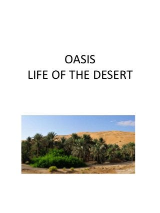
The economy of Liwa Oasis rests on agriculture producing mainly dates, and
some tourism. Infrastructure is excellent, with well-maintained farms. Green
houses are used extensively, as well as fibreglass matting tunnels and drip
irrigation for outdoor crops. Around the farms, high sand dunes rise.
Abu Dhabi city is 200 km northeast, along a first-class highway.
Liwa Oasis is shaped as a perfect arc, 120 km long, with the road to the rest
of the country right at its middle.
The central, and largest settlement is Mizaira'a. The easternmost settlement
is Hamim, the westernmost is Arada.
Traditionally, men from Liwa were pearl divers on the coast during the
summer months.
Liwa Oasis is the ancestral home of the rulers of Abu Dhabi, the an-Nahyan
family.
Liwa Oasis
Arabic: wāha līwā
4. GEOGRAPHY
• Liwa Oasis is about 100 km south of the Persian Gulf coast and 150 km
SSW of the city of Abu Dhabi, on the northern edge of Rub' al Khali
desert.
• 23°08′N 53°46′E/ 23.133°N 53.767°E/ 23.133; 53.767 and stretches
about 100 km east-west, along an arch curved to the north. It consists of
some 50 villages. The geographic and economic center of the oasis is
Muzayri`, where the highway from Abu Dhabi enters the oasis and then
divides to the east (65 km to the easternmost village, Mahdar Bin
`Usayyan) and west (45 km to the westernmost village, `Aradah).
• There are no statistical data available, but judging from satellite
images, the population is estimated at 50,000 to 150,000.[1]
• The villages of Liwa Oasis are the southernmost settlements of Abu
Dhabi and of the United Arab Emirates. The southern border of Abu
Dhabi with Saudi Arabia, which runs at a distance between 16 and 35 km
to the Oasis, is a straight line in the Rub al Khali desert, which is largely
uninhabited. Mahdar Bin `Usayyan is the southermost village of the
Emirates, and also the easternmost of the oasis. 10 km south of the
border, and 40 km south of the eastern part of the oasis is the Saudi oil
facility Shaybah. However, there is no road linking Liwa Oasis and
Shaybah, and no border crossing.
• A modern, multilane highway connects the oasis area to the capital, Abu
Dhabi.[citation needed]
5. ECONOMY
• An important traditional branch of the economy
is date farming. There is a widespread use of drip
irrigation and greenhouses. The importance of
tourism is on the rise. Liwa Hotel in Muzayri`
boasts four stars. Liwa Rest House, in the same
village and run by the government of Abu
Dhabi, is the second establishment in the oasis. It
is primarily aimed at minor officials and
businessmen. Construction has begun on a
third, 5 star, resourt (named Qasr Al Sarab). The
nearby Moreeb duneWikiMiniAtlas
• 22°59′N 53°47′E/ 22.983°N 53.783°E/
22.983; 53.783, 22 km south of Muzayri` on a
small road (15 km as the crow flies), with 300
meter height one of the largest dunes in the
world, attracts every year during the Liwa festival
a large number of international and local visitors
coming to see the offroad and camel racing
events.
6. HISTORY
• The oasis is the place of birth of the ruling
families of Abu Dhabi and Dubai.
• The arc of the villages of Liwa were the focus
of economic and social activity of the Bani
Yas Tribe.
• In 1793, the ruling family Al Nahyan moved
their residence from Liwa to the city of Abu
Dhabi.
• Traditionally, men from Liwa (Bani Yas tribe)
were pearl divers on the coast during the
summer months. Pearl diving offered an
additional source of income
7. • An aquifer system in the Liwa Crescent/ Bu Hasa area of the Emirate of Abu
• Dhabi on the southeastern edge of the Rub al Khali, Arabian sub-
continent, provides insight into the timing
• of ground-water recharge and the origin and evolution of solutes in a
representative hyperarid area. Groundwater
• flow in the aquifer system is radially outward from the center of two ground-water
mounds,
• corresponding to two 110 m-thick sand deposits. The isotopic data from ancient
ground waters from the
• Liwa Oasis with its unusual “d” (deuterium excess) of approximately -15 indicate
that Holocene moisture
• derived from previously evaporated water on the surface of the Indian Ocean rather
than from the
• Mediterranean/Arabian Gulf. Such a source is consistent with a summer monsoonal
circulation. an aquifer system in the Liwa Crescent/ Bu Hasa area of the Emirate of
Abu
• Dhabi on the southeastern edge of the Rub al Khali, Arabian sub-
continent, provides insight into the timing
• of ground-water recharge and the origin and evolution of solutes in a
representative hyperarid area. Groundwater
• flow in the aquifer system is radially outward from the center of two ground-water
mounds,
• corresponding to two 110 m-thick sand deposits. The isotopic data from ancient
ground waters from the
• Liwa Oasis with its unusual “d” (deuterium excess) of approximately -15 indicate
that Holocene moisture
• derived from previously evaporated water on the surface of the Indian Ocean rather
than from the
• Mediterranean/Arabian Gulf. Such a source is consistent with a summer monsoonal
circulation.