Submit Search
Upload
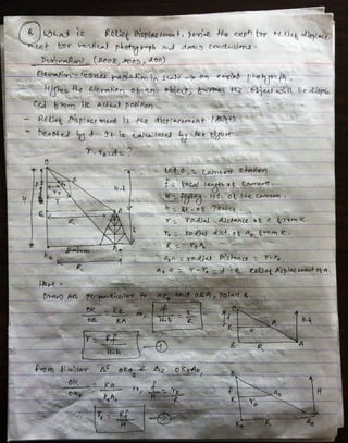
Numerical from-photogrammetry-and-relief-displacement-derivation
•
6 likes
•
3,024 views
Gokul Saud
Follow
Report
Share
Report
Share
1 of 10
Download now
Download to read offline
Recommended
Lecture 1-aerial photogrammetry
Lecture 1-aerial photogrammetry
Vidhi Khokhani
Relief displacement
Relief displacement
Mr Amol Ghogare
Topic stereoscopy, Parallax, Relief displacement
Topic stereoscopy, Parallax, Relief displacement
srinivas2036
Triangulation and Trilateration
Triangulation and Trilateration
Pramesh Hada
Total Station & GPS
Total Station & GPS
Akshay Krishna K R
Gis application in civil engineering
Gis application in civil engineering
Amal C Varghese
traversing of survey
traversing of survey
Self-employed
DIFFERENTIAL GPS (DGPS)
DIFFERENTIAL GPS (DGPS)
KU Leuven
Surveying with gps
Surveying with gps
engr jafar
Lecture 6 vertical photographs
Lecture 6 vertical photographs
Sarhat Adam
Global positioning system_Surveying, Civil Engineering
Global positioning system_Surveying, Civil Engineering
A Makwana
Aerial Photogrammetry
Aerial Photogrammetry
Mujeeb Muji
Dgps
Dgps
baljinder5590
Distortions and displacement on aerial photograph
Distortions and displacement on aerial photograph
chandan00781
GPS Surveying
GPS Surveying
Malla Reddy University
Lecture 08 tilted photograph
Lecture 08 tilted photograph
Sarhat Adam
Total station Surveying
Total station Surveying
Kiran M
Introduction to aerial photography and photogrammetry.ppt
Introduction to aerial photography and photogrammetry.ppt
srinivas2036
Vertical aerial photographs
Vertical aerial photographs
Collation Soft Solutions Pvt.Ltd
Remote Sensing Platforms and Sensors
Remote Sensing Platforms and Sensors
Uday kumar Devalla
Gps surveying
Gps surveying
gayathrysatheesan1
Tacheometry ppt
Tacheometry ppt
Vilas Nikam
Basic of gis concept and theories
Basic of gis concept and theories
Mohsin Siddique
Lecture 7 setero parllax
Lecture 7 setero parllax
Sarhat Adam
Photogrammetry- Surveying
Photogrammetry- Surveying
Gokul Saud
Scale of photograph (Aerial Photogrammetry)
Scale of photograph (Aerial Photogrammetry)
Mr Amol Ghogare
Gps and its application
Gps and its application
shubham paliwal
Geometry of Aerial photograph
Geometry of Aerial photograph
Apoorva Mathur
Surveying ii module iii class 3
Surveying ii module iii class 3
SHAMJITH KM
Orthorectification and triangulation
Orthorectification and triangulation
Mesfin Yeshitla
More Related Content
What's hot
Surveying with gps
Surveying with gps
engr jafar
Lecture 6 vertical photographs
Lecture 6 vertical photographs
Sarhat Adam
Global positioning system_Surveying, Civil Engineering
Global positioning system_Surveying, Civil Engineering
A Makwana
Aerial Photogrammetry
Aerial Photogrammetry
Mujeeb Muji
Dgps
Dgps
baljinder5590
Distortions and displacement on aerial photograph
Distortions and displacement on aerial photograph
chandan00781
GPS Surveying
GPS Surveying
Malla Reddy University
Lecture 08 tilted photograph
Lecture 08 tilted photograph
Sarhat Adam
Total station Surveying
Total station Surveying
Kiran M
Introduction to aerial photography and photogrammetry.ppt
Introduction to aerial photography and photogrammetry.ppt
srinivas2036
Vertical aerial photographs
Vertical aerial photographs
Collation Soft Solutions Pvt.Ltd
Remote Sensing Platforms and Sensors
Remote Sensing Platforms and Sensors
Uday kumar Devalla
Gps surveying
Gps surveying
gayathrysatheesan1
Tacheometry ppt
Tacheometry ppt
Vilas Nikam
Basic of gis concept and theories
Basic of gis concept and theories
Mohsin Siddique
Lecture 7 setero parllax
Lecture 7 setero parllax
Sarhat Adam
Photogrammetry- Surveying
Photogrammetry- Surveying
Gokul Saud
Scale of photograph (Aerial Photogrammetry)
Scale of photograph (Aerial Photogrammetry)
Mr Amol Ghogare
Gps and its application
Gps and its application
shubham paliwal
Geometry of Aerial photograph
Geometry of Aerial photograph
Apoorva Mathur
What's hot
(20)
Surveying with gps
Surveying with gps
Lecture 6 vertical photographs
Lecture 6 vertical photographs
Global positioning system_Surveying, Civil Engineering
Global positioning system_Surveying, Civil Engineering
Aerial Photogrammetry
Aerial Photogrammetry
Dgps
Dgps
Distortions and displacement on aerial photograph
Distortions and displacement on aerial photograph
GPS Surveying
GPS Surveying
Lecture 08 tilted photograph
Lecture 08 tilted photograph
Total station Surveying
Total station Surveying
Introduction to aerial photography and photogrammetry.ppt
Introduction to aerial photography and photogrammetry.ppt
Vertical aerial photographs
Vertical aerial photographs
Remote Sensing Platforms and Sensors
Remote Sensing Platforms and Sensors
Gps surveying
Gps surveying
Tacheometry ppt
Tacheometry ppt
Basic of gis concept and theories
Basic of gis concept and theories
Lecture 7 setero parllax
Lecture 7 setero parllax
Photogrammetry- Surveying
Photogrammetry- Surveying
Scale of photograph (Aerial Photogrammetry)
Scale of photograph (Aerial Photogrammetry)
Gps and its application
Gps and its application
Geometry of Aerial photograph
Geometry of Aerial photograph
Viewers also liked
Surveying ii module iii class 3
Surveying ii module iii class 3
SHAMJITH KM
Orthorectification and triangulation
Orthorectification and triangulation
Mesfin Yeshitla
Intersection designs ppt
Intersection designs ppt
Sowjanya Gannoju
Types of intersection of road and design parameters of road intersection
Types of intersection of road and design parameters of road intersection
waiseee
Photogrammetry 1.
Photogrammetry 1.
Naveen Kumar
Lecture on photogrammetry
Lecture on photogrammetry
Waleed Liaqat
Viewers also liked
(6)
Surveying ii module iii class 3
Surveying ii module iii class 3
Orthorectification and triangulation
Orthorectification and triangulation
Intersection designs ppt
Intersection designs ppt
Types of intersection of road and design parameters of road intersection
Types of intersection of road and design parameters of road intersection
Photogrammetry 1.
Photogrammetry 1.
Lecture on photogrammetry
Lecture on photogrammetry
More from Gokul Saud
Cementing Materials
Cementing Materials
Gokul Saud
Water Induced Disaster Risk Management
Water Induced Disaster Risk Management
Gokul Saud
Contouring pdf
Contouring pdf
Gokul Saud
Chapter 3 classification
Chapter 3 classification
Gokul Saud
Global positioning system (gps)
Global positioning system (gps)
Gokul Saud
Consolidation nec
Consolidation nec
Gokul Saud
Chapter one gis
Chapter one gis
Gokul Saud
Microsoft power point distribution systems [read-only]
Microsoft power point distribution systems [read-only]
Gokul Saud
Membrane filtration
Membrane filtration
Gokul Saud
Last day note
Last day note
Gokul Saud
Water treatment
Water treatment
Gokul Saud
Hydrographic survey for std not print
Hydrographic survey for std not print
Gokul Saud
Pipe appuretenances, valves and fittings
Pipe appuretenances, valves and fittings
Gokul Saud
Remote sensing
Remote sensing
Gokul Saud
Soil mecahnics ka notes
Soil mecahnics ka notes
Gokul Saud
Chapter 9 gravity flow water supply system
Chapter 9 gravity flow water supply system
Gokul Saud
Chapter 7 conveyance of water
Chapter 7 conveyance of water
Gokul Saud
Triangulation and trilateration pdf...
Triangulation and trilateration pdf...
Gokul Saud
More from Gokul Saud
(18)
Cementing Materials
Cementing Materials
Water Induced Disaster Risk Management
Water Induced Disaster Risk Management
Contouring pdf
Contouring pdf
Chapter 3 classification
Chapter 3 classification
Global positioning system (gps)
Global positioning system (gps)
Consolidation nec
Consolidation nec
Chapter one gis
Chapter one gis
Microsoft power point distribution systems [read-only]
Microsoft power point distribution systems [read-only]
Membrane filtration
Membrane filtration
Last day note
Last day note
Water treatment
Water treatment
Hydrographic survey for std not print
Hydrographic survey for std not print
Pipe appuretenances, valves and fittings
Pipe appuretenances, valves and fittings
Remote sensing
Remote sensing
Soil mecahnics ka notes
Soil mecahnics ka notes
Chapter 9 gravity flow water supply system
Chapter 9 gravity flow water supply system
Chapter 7 conveyance of water
Chapter 7 conveyance of water
Triangulation and trilateration pdf...
Triangulation and trilateration pdf...
Download now